

A buried submarine canyon in the northwest South China Sea: architecture, development processes and implications for hydrocarbon exploration
-
Abstract: High-resolution multichannel seismic data enables the discovery of a previous, undocumented submarine canyon (Huaguang Canyon) in the Qiongdongnan Basin, northwest South China Sea. The Huaguang Canyon with a NW orientation is 140 km in length, and 2.5 km to 5 km in width in its upper reach and 4.6 km to 9.5 km in width in its lower reach. The head of the Huaguang Canyon is close to the Xisha carbonate platform and its tail is adjacent to the central canyon. This buried submarine canyon is formed by gravity flows from the Xisha carbonate platform when the sea level dropped in the early stage of the late Miocene (~10.5 Ma). The internal architecture of the Huaguang Canyon is mainly characterized by high amplitude reflections, indicating that this ancient submarine canyon was filled with coarse-grained sediments. The sediment was principally scourced from the Xisha carbonate platform. In contrast to other buried large-scale submarine canyons (central canyon and Zhongjian Canyon) in the Qiongdongnan Basin, the Huaguang Canyon displays later formation time, smaller width and length, and single sediment supply. The coarse-grained deposits within Huaguang Canyon provide a good environment for reserving oil and gas, and the muddy fillings in Huaguang Canyon have been identified as regional caps. Therefore, Huaguang Canyon is potential area for future hydrocarbon exploration in the northwest South China Sea. Our results may contribute to a better understanding of the evolution of submarine canyons formed in carbonate environment.
-
Key words:
- South China Sea /
- Qiongdongnan Basin /
- submarine canyon /
- evolution
-
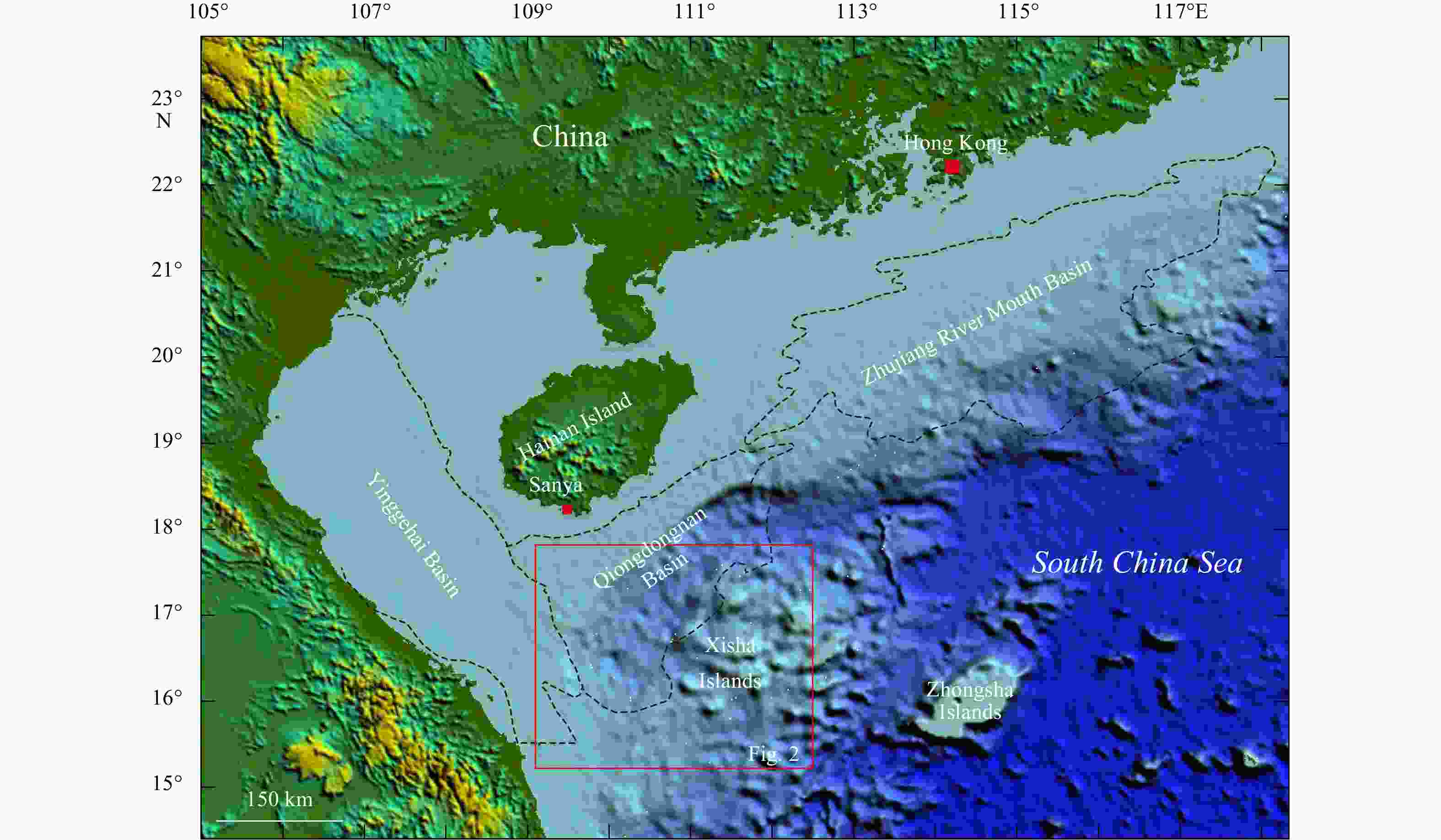
Figure 1. Location map of the study area in the Qiongdongnan Basin on the northwestern South China Sea margin. The black dotted lines present the boundaries of the Zhujiang River Mouth Basin, the Qiongdongnan Basin and the Yinggehai Basin. The red box indicates the location of Fig. 2. Major topographical features, including Hainan Island, Xisha Islands and Zhongsha Islands are marked.


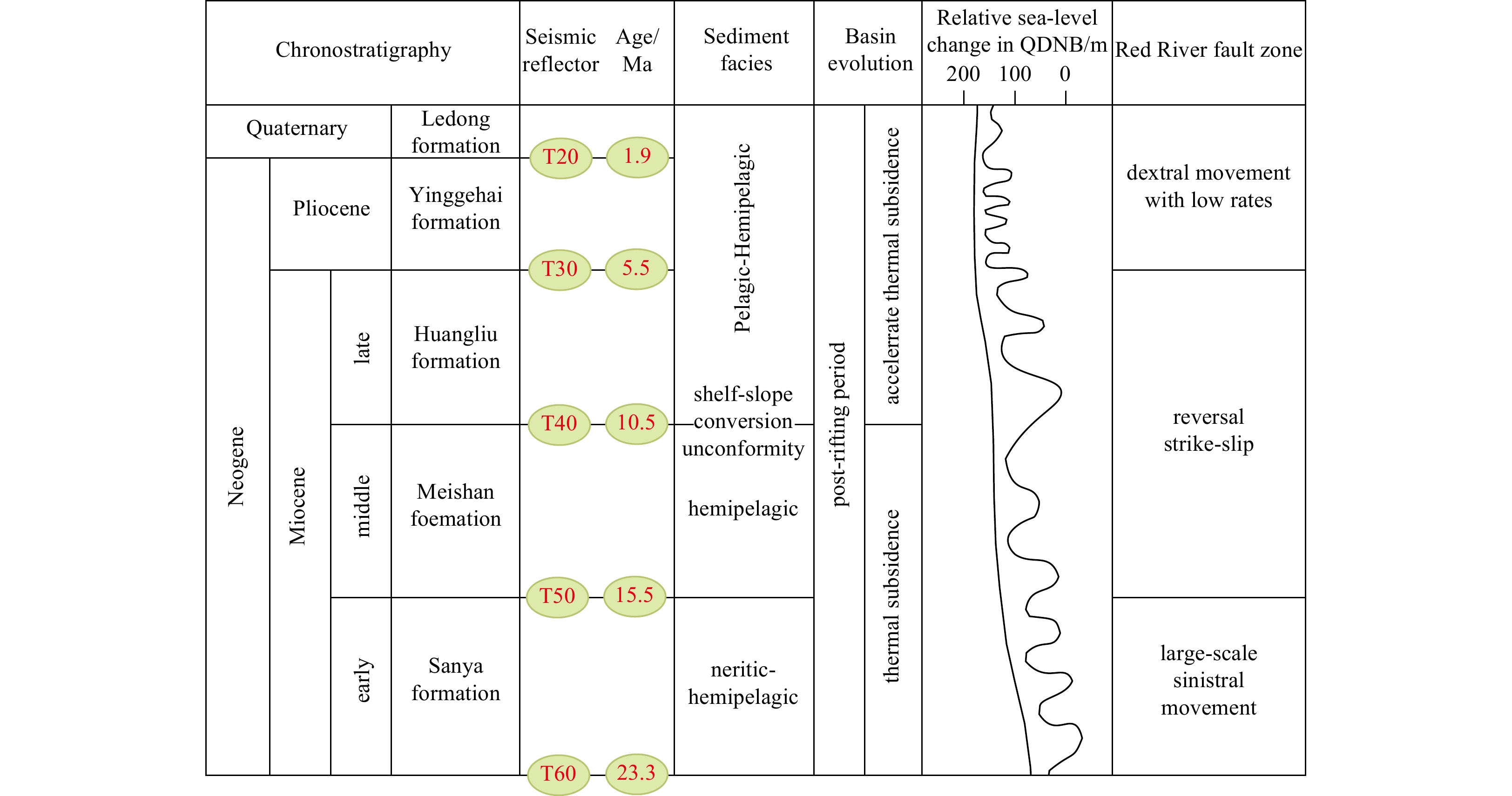
Figure 3. The Chronostratigraphy profile of the Qiongdongnan Basin from Neogene to Quaternary. The sea level change of Qiongdongnan Basin (QDNB) and global eustatic were adopted from Haq et al. (1987).
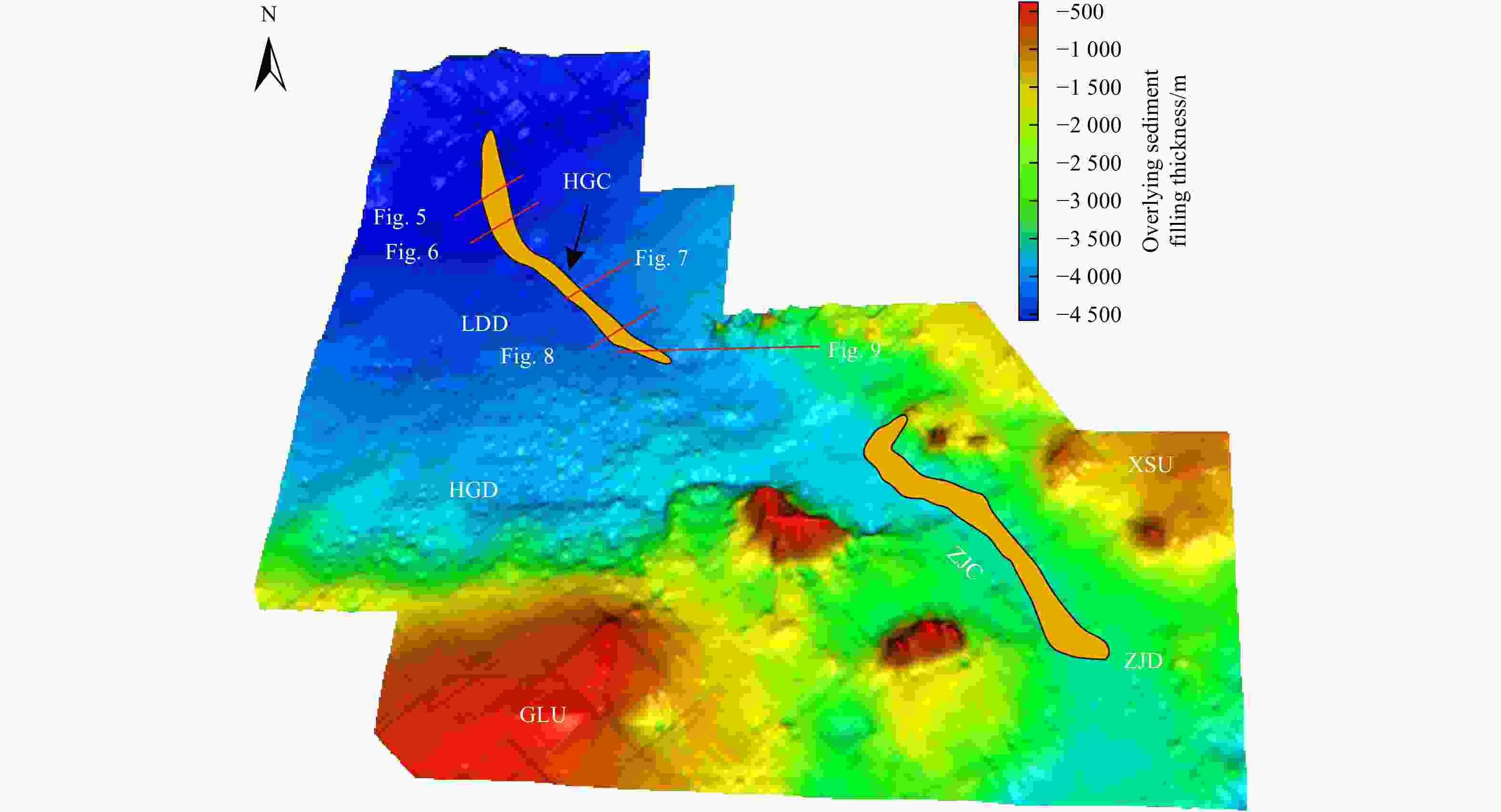
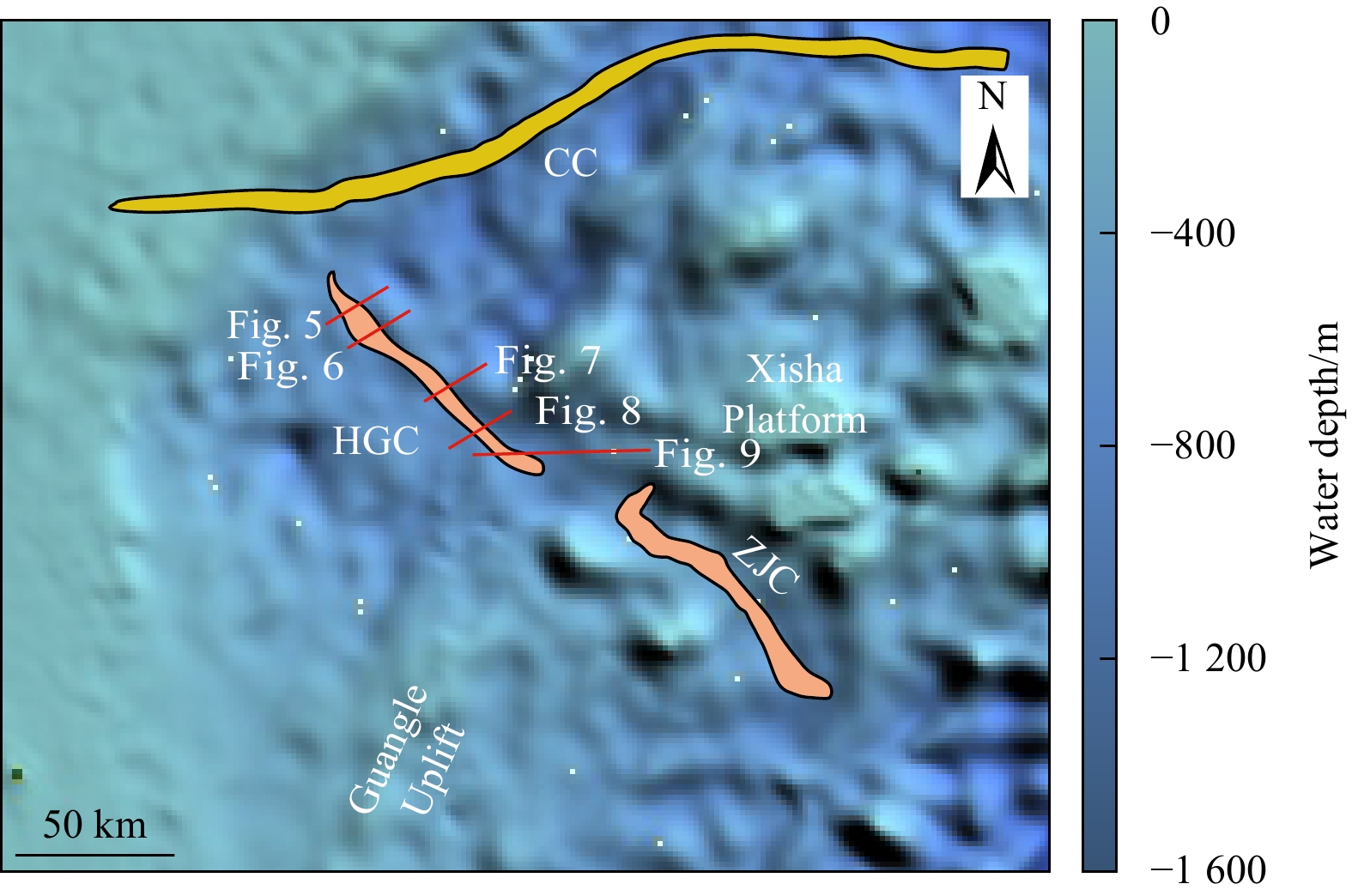
Figure 4. The paleogeomorphic map of study area in later Miocene with overlying sediment filling thickness ranging from –4 500 m to –500 m. The red lines indicate the seismic profiles in Figs 5, 6, 7, 8 and 9. The orange area in the northwestern of the map denotes the Huaguang Canyon (HGC), and the orange regions in the southeastern of the map indicate the Zhongjian Canyon (ZJC). HGD: Huaguang depression, XSU: Xisha uplift, ZJD: Zhongjian depression, GLU: Guangle uplift, LDD: Ledong depression, and ZJC: Zhongjian Canyon.
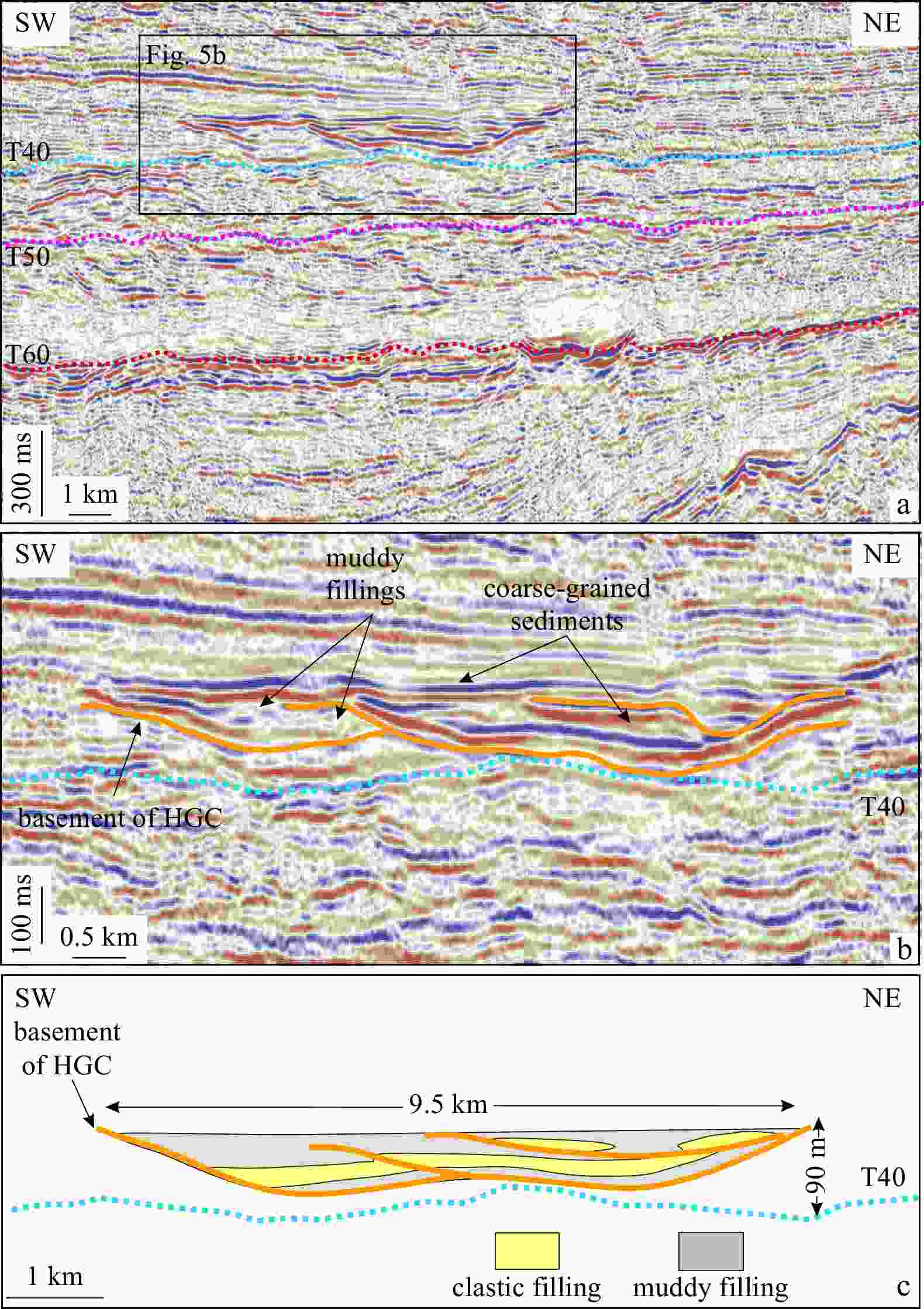
Figure 5. Cross-sectional seismic profiles across the lower reach of Huaguang Channel (HGC) (a), the buried channels lies in the middle area of the seismic profile (b), and the sketch profile shows deposits buried in the Huaguang Channel (c). Locations of seismic profiles are shown in Fig. 2. The Huaguang Channel is 9.5 km in width and 90 m in depth. The black box in a indicates the buried channels in b, the orange line in b indicates the basement of Huaguang Channel, the yellow section in c indicates the clastic fillings and grey indicates the muddy fillings.
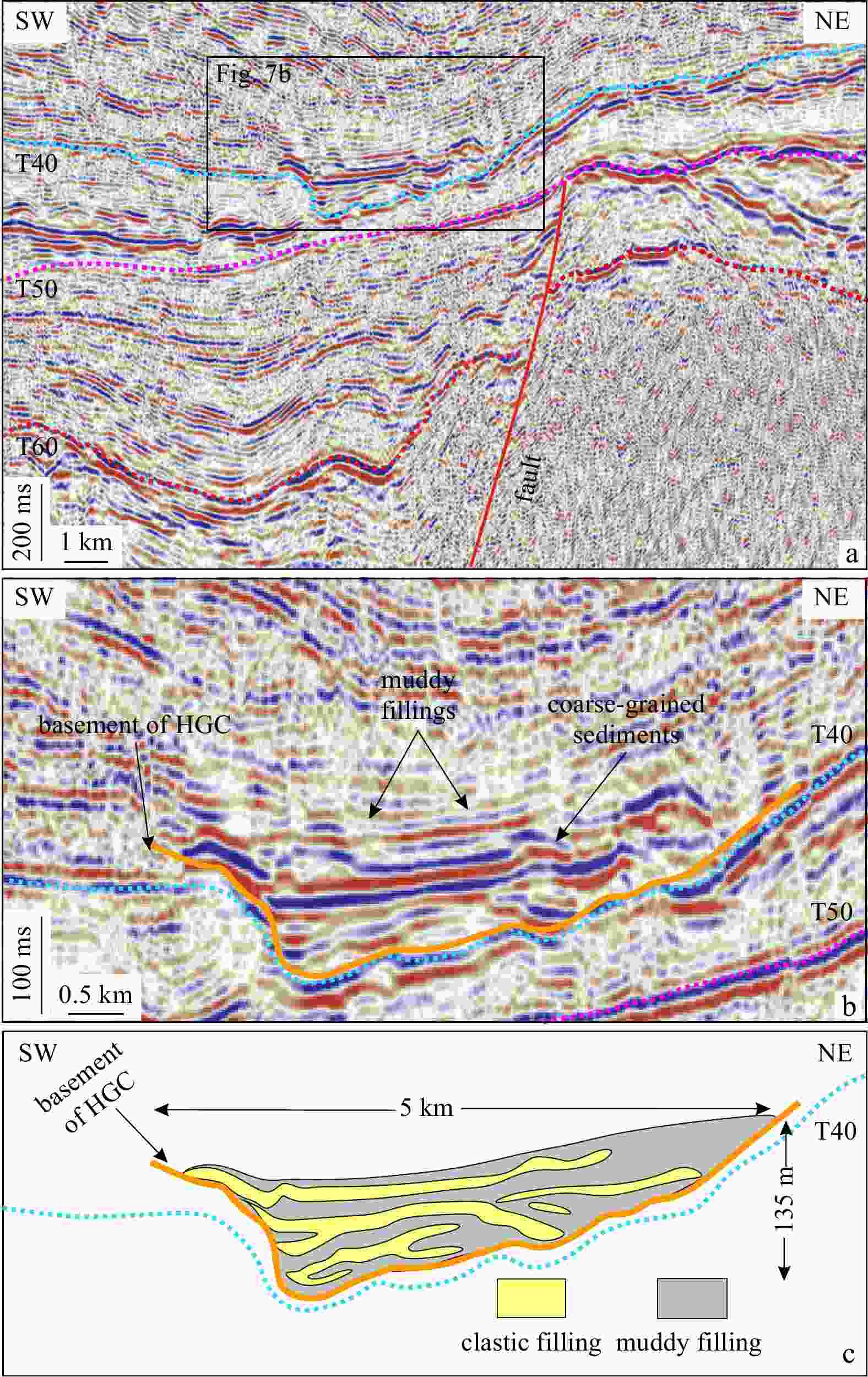
Figure 7. Cross-sectional seismic profiles across the upper reach of HuaGuang Channel (HGC) (a), the seismic profile shows that the buried channels are distributed near the upper reach (b), and the sketch profile show deposits buried in the Huaguang Channel (c). Locations of seismic profiles are shown in Fig. 2. The Huaguang Channel is 5 km in width and 135 m in depth. The black box in a indicates the buried channels in Fig. 7b, the orange line in b indicates the basement of Huaguang Channel, the yellow section in c indicates the clastic fillings and grey indicates the muddy fillings.

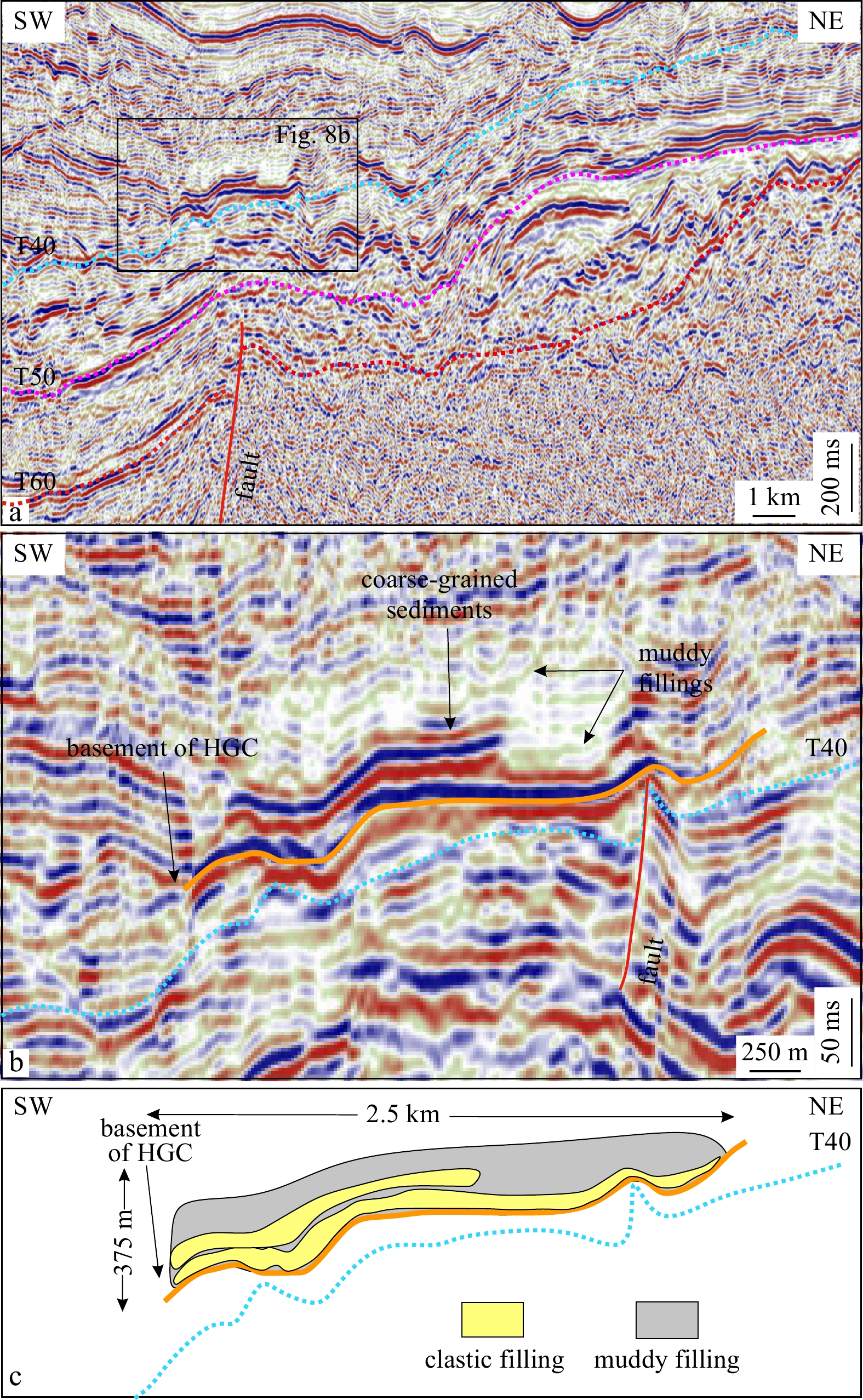
Figure 8. Cross-sectional seismic profiles across the upper reach of HuaGuang Channel (HGC) (a), the buried channels are closed to the southwestern area of the seismic profile (b), and the sketch profile show deposits buried in the Huaguang Channel (c). Locations of seismic profiles are shown in Fig. 2. The Huaguang Channel is 2.5 km in width and 375 m in depth. The black box in a indicates the buried channels in Fig. 8b, the orange line in b indicates the basement of Huaguang Channel, the yellow section in c indicates the clastic fillings and grey indicates the muddy fillings.
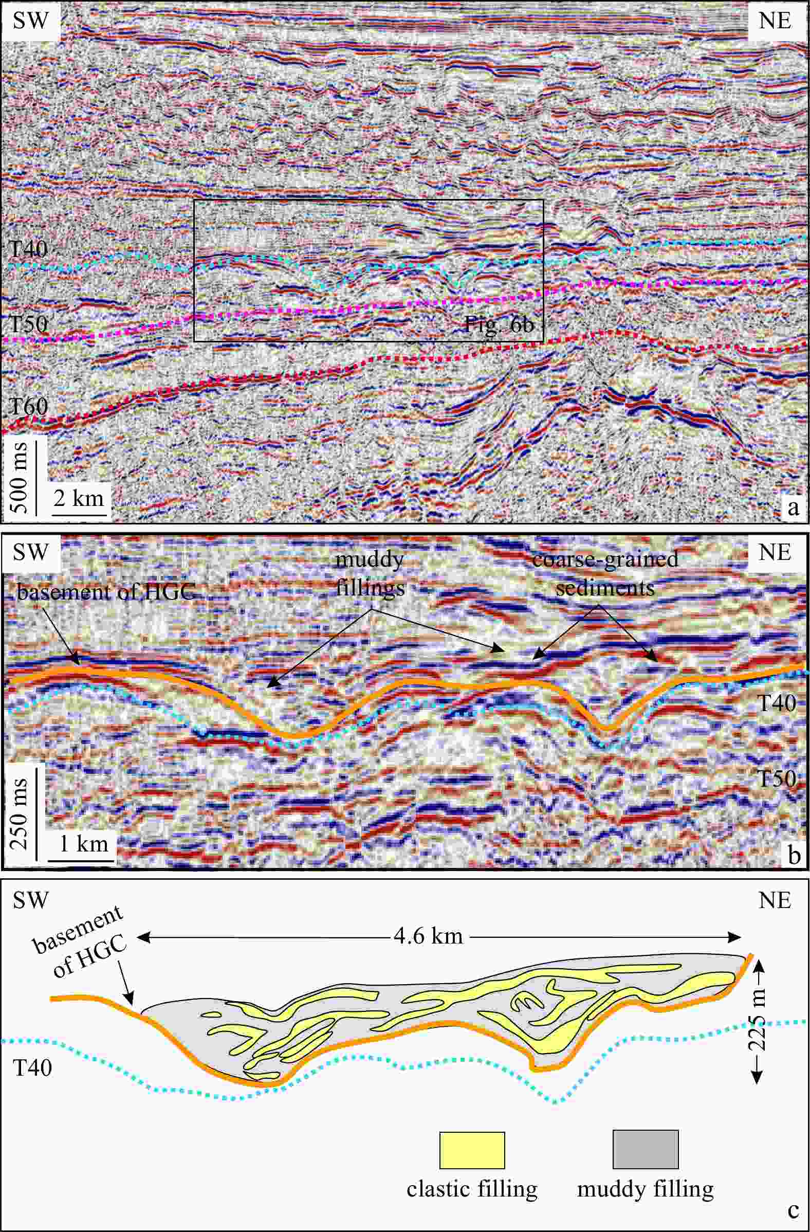
Figure 6. Cross-sectional seismic profiles across the middle reach of Huaguang Channel (HGC) (a), the buried channels are located in the upper region of the seismic profile (b), and the sketch profile shows deposits buried in the Huaguang Channel (c). Locations of seismic profiles are shown in Fig. 2. The Huaguang Channel is 4.6 km in width and 225 m in depth. The black box in a indicates the buried channels in Fig. 6b, the orange line in b indicates the basement of Huaguang Channel, the yellow section in c indicates the clastic fillings and grey indicates the muddy fillings.
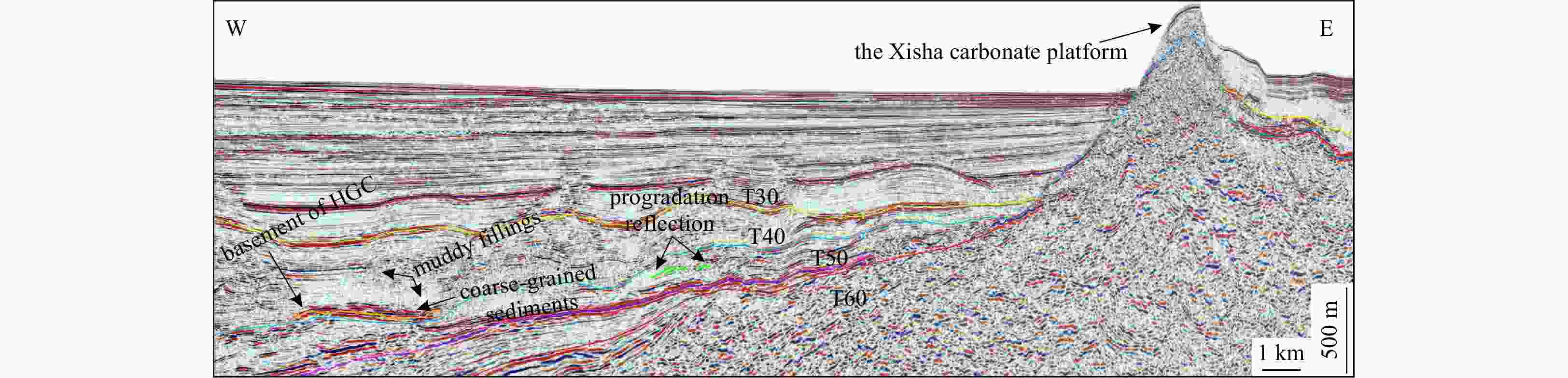
Figure 9. The seismic profile is shown in Figs 2 and 4. The Xisha carbonate platform and the Huaguang Channel (HGC) are shown in the cross-sectional seismic profile. The orange line indicates the basement of the Huaguang Channel. The green lines represent the progradation reflection. The high-amplitude reflection indicates the clastic fillings and the strong and high reflections indicate the muddy fillings.
-
[1] Anderson K S, Graham S A, Hubbard S M. 2006. Facies, architecture, and origin of a reservoir-scale sand-rich succession within submarine canyon fill: insights from wagon caves rock (paleocene), Santa Lucia range, California, U.S.A. Journal of Sedimentary Research, 76(5): 819–838. doi: 10.2110/jsr.2006.066 [2] Baztan J, Berné S, Olivet J L, et al. 2005. Axial incision: the key to understand submarine canyon evolution (in the western Gulf of Lion). Marine and Petroleum Geology, 22(6–7): 805–826 [3] Bouma A H. 2004. Key controls on the characteristics of turbidite systems. Geological Society, London, Special Publications, 222(1): 9–22. doi: 10.1144/GSL.SP.2004.222.01.02 [4] Clark J D, Pickering K T. 1996. Architectural elements and growth patterns of submarine channels: application to hydrocarbon exploration. AAPG Bulletin, 80(2): 194–221 [5] Clift P D, Giosan L, Henstock T J, et al. 2014. Sediment storage and reworking on the shelf and in the Canyon of the Indus River-Fan System since the last glacial maximum. Basin Research, 26(1): 183–202 [6] Clift P D, Sun Zhen. 2006. The sedimentary and tectonic evolution of the Yinggehai-Song Hong Basin and the southern Hainan margin, South China Sea: implications for Tibetan uplift and monsoon intensification. Journal of Geophysical Research: Solid Earth, 111(B6): B06405 [7] Cossu R, Wells M G. 2013. The evolution of submarine channels under the influence of Coriolis forces: experimental observations of flow structures. Terra Nova, 25(1): 65–71 [8] Crossey L J, Fischer T P, Patchett P J, et al. 2006. Dissected hydrologic system at the Grand Canyon: Interaction between deeply derived fluids and plateau aquifer waters in modern springs and travertine. Geology, 34(1): 25–28. doi: 10.1130/G22057.1 [9] de Leeuw J, Eggenhuisen J T, Cartigny M J B. 2016. Morphodynamics of submarine channel inception revealed by new experimental approach. Nature Communications, 7: 10886 [10] Ding Weiwei, Li Jiabiao, Li Jun, et al. 2013. Morphotectonics and evolutionary controls on the Pearl River Canyon system, South China Sea. Marine Geophysical Research, 34(3–4): 221–238 [11] Feng Jingchun, Wang Yi, Li Xiaosen, et al. 2015. Production performance of gas hydrate accumulation at the GMGS2-Site 16 of the Pearl River Mouth Basin in the South China Sea. Journal of Natural Gas Science and Engineering, 27: 306–320. doi: 10.1016/j.jngse.2015.08.071 [12] Fyhn M B W, Nielsen L H, Boldreel L O, et al. 2009. Geological evolution, regional perspectives and hydrocarbon potential of the northwest Phu Khanh Basin, offshore Central Vietnam. Marine and Petroleum Geology, 26(1): 1–24. doi: 10.1016/j.marpetgeo.2007.07.014 [13] Gong Chenglin, Wang Yingmin, Zhu Weilin, et al. 2011. The Central Submarine Canyon in the Qiongdongnan Basin, northwestern South China Sea: architecture, sequence stratigraphy, and depositional processes. Marine and Petroleum Geology, 28(9): 1690–1702. doi: 10.1016/j.marpetgeo.2011.06.005 [14] Green A, Uken R. 2008. Submarine landsliding and canyon evolution on the northern KwaZulu-Natal continental shelf, South Africa, SW Indian Ocean. Marine Geology, 254(3–4): 152–170 [15] Haq B U, Hardenbol J A N, Vail P R. 1987. Chronology of fluctuating sea levels since the Triassic. Science, 235(4793): 1156–1167. doi: 10.1126/science.235.4793.1156 [16] Harris P T, Whiteway T. 2011. Global distribution of large submarine canyons: geomorphic differences between active and passive continental margins. Marine Geology, 285(1–4): 69–86 [17] Kolla V. 2007. A review of sinuous channel avulsion patterns in some major deep-sea fans and factors controlling them. Marine and Petroleum Geology, 24(6–9): 450–469 [18] Kuang Zenggui, Zhong Guangfa, Wang Liaoliang, et al. 2014. Channel-related sediment waves on the eastern slope offshore Dongsha Islands, northern South China Sea. Journal of Asian Earth Sciences, 79: 540–551. doi: 10.1016/j.jseaes.2012.09.025 [19] Lüdmann T, Wong H K, Wang Pinxian. 2001. Plio–Quaternary sedimentation processes and neotectonics of the northern continental margin of the South China Sea. Marine Geology, 172(3–4): 331–358 [20] Lamb M A, Anderson K S, Graham S A. 2003. Stratigraphic Architecture of A Sand-Rich, Deep-Sea Depositional System: the Stevens Sandstone, San Joaquin Basin, California. California: Pacific Seciton AAPG Publication [21] Leach A S, Wallace M W. 2001. Cenozoic submarine canyon systems in cool water carbonates from the Otway Basin, Victoria, Australia. In: Hill K C, Bernecker T, eds. Eastern Australasian Basins Symposium, A Refocused Energy Perspective for the Future. Petroleum Exploration Society of Australia Special Publication, 1: 465–473 [22] Li Xiangquan, Fairweather L, Wu Shiguo, et al. 2013. Morphology, sedimentary features and evolution of a large palaeo submarine canyon in Qiongdongnan Basin, northern South China Sea. Journal of Asian Earth Sciences, 62: 685–696. doi: 10.1016/j.jseaes.2012.11.019 [23] Li Chunfeng, Li Jiabiao, Ding Weiwei, et al. 2015. Seismic stratigraphy of the central South China Sea basin and implications for neotectonics. Journal of Geophysical Research: Solid Earth, 120(3): 1377–1399. doi: 10.1002/2014JB011686 [24] Lofi J, Berné S. 2008. Evidence for pre-Messinian submarine canyons on the Gulf of Lions slope (Western Mediterranean). Marine and Petroleum Geology, 25(8): 804–817. doi: 10.1016/j.marpetgeo.2008.04.006 [25] Lu Yintao, Li Wei, Wu Shiguo, et al. 2018. Morphology, architecture, and evolutionary processes of the Zhongjian Canyon between two carbonate platforms, South China Sea. Interpretation, 6(4): SO1–SO15 [26] Mayall M, Jones E, Casey M. 2006. Turbidite channel reservoirs—Key elements in facies prediction and effective development. Marine and Petroleum Geology, 23(8): 821–841 [27] McHargue T, Pyrcz M J, Sullivan M D, et al. 2011. Architecture of turbidite channel systems on the continental slope: patterns and predictions. Marine and Petroleum Geology, 28(3): 728–743. doi: 10.1016/j.marpetgeo.2010.07.008 [28] Mondziel S, Grindlay N, Mann P, et al. 2010. Morphology, structure, and tectonic evolution of the Mona canyon (northern Mona passage) from multibeam bathymetry, side-scan sonar, and seismic reflection profiles. Tectonics, 29(2): TC2003 [29] Normark W R, Carlson P R. 2003. Giant submarine canyons: Is size any clue to their importance in the rock record?. In: Chan M A, Archer A W, eds. Extreme Depositional Environments: Mega end Members in Geologic Time. Boulder: Geological Society of America, 370: 175–190 [30] Ortiz-Karpf A, Hodgson D M, Mccaffrey W D. 2015. The role of mass-transport complexes in controlling channel avulsion and the subsequent sediment dispersal patterns on an active margin: the Magdalena Fan, offshore Colombia. Marine and Petroleum Geology, 64: 58–75. doi: 10.1016/j.marpetgeo.2015.01.005 [31] Peakall J, Kane I A, Masson D G, et al. 2012. Global (latitudinal) variation in submarine channel sinuosity. Geology, 40(1): 11–14. doi: 10.1130/G32295.1 [32] Piper D J W, Normark W R. 1983. Turbidite depositional patterns and flow characteristics, Navy Submarine Fan, California Borderland. Sedimentology, 30(5): 681–694. doi: 10.1111/j.1365-3091.1983.tb00702.x [33] Posamentier H W, Kolla V. 2003. Seismic geomorphology and stratigraphy of depositional elements in deep-water settings. Journal of Sedimentary Research, 73(3): 367–388. doi: 10.1306/111302730367 [34] Pratson L F, Coakley B J. 1996. A model for the headward erosion of submarine canyons induced by downslope-eroding sediment flows. GSA Bulletin, 108(2): 225–234. doi: 10.1130/0016-7606(1996)108<0225:AMFTHE>2.3.CO;2 [35] Puga-Bernabéu A, Martín J M, Braga J C. 2008. Sedimentary processes in a submarine canyon excavated into a temperate-carbonate ramp (Granada Basin, southern Spain). Sedimentology, 55(5): 1449–1466. doi: 10.1111/j.1365-3091.2008.00952.x [36] Richards M, Bowman M, Reading H. 1998. Submarine-fan systems i: characterization and stratigraphic prediction. Marine and Petroleum Geology, 15(7): 689–717. doi: 10.1016/S0264-8172(98)00036-1 [37] Ru Ke, Pigott J D. 1986. Episodic rifting and subsidence in the South China Sea. AAPG Bull, 70(9): 1136–1155 [38] Scholle P A. 1977. Chalk diagenesis and its relation to petroleum exploration: oil from chalks, a modern miracle?. AAPG Bulletin, 61(7): 982–1009 [39] Shao Lei, Cui Yuchi, Qiao Peijun, et al. 2017a. Sea-level changes and carbonate platform evolution of the Xisha Islands (South China Sea) since the Early Miocene. Palaeogeography, Palaeoclimatology, Palaeoecology, 485: 504–516. doi: 10.1016/j.palaeo.2017.07.006 [40] Shao Lei, Li Qianyu, Zhu Weilin, et al. 2017b. Neogene carbonate platform development in the NW South China Sea: litho-, bio- and chemo-stratigraphic evidence. Marine Geology, 385: 233–243 [41] Shepard F P. 1981. Submarine canyons: multiple causes and long-time persistence. AAPG Bulletin, 65(6): 1062–1077 [42] Shepard F P, Dill R F. 1966. Marine Geology. (Book Reviews: Submarine Canyons and Other Sea Valleys). Science, 154(3755): 1433–1434, doi: 10.1126/science.154.3755.1433 [43] Sibuet J C, Yeh Y C, Lee C S. 2016. Geodynamics of the South China Sea. Tectonophysics, 692: 98–119 [44] Su Ming, Xie Xinong, Xie Yuhong, et al. 2014. The segmentations and the significances of the Central Canyon System in the Qiongdongnan Basin, northern South China Sea. Journal of Asian Earth Sciences, 79: 552–563. doi: 10.1016/j.jseaes.2012.12.038 [45] Sun Qiliang, Wu Shiguo, Hovland M, et al. 2011. The morphologies and genesis of mega-pockmarks near the Xisha Uplift, South China Sea. Marine & Petroleum Geology, 28(6): 1146–1156 [46] Sun Qiliang, Wu Shiguo, Lü Fuliang, et al. 2010. Polygonal faults and their implications for hydrocarbon reservoirs in the southern Qiongdongnan Basin, South China Sea. Journal of Asian Earth Sciences, 39(5): 470–479. doi: 10.1016/j.jseaes.2010.04.002 [47] Twichell D C, Roberts D G. 1982. Morphology, distribution, and development of submarine canyons on the United States Atlantic continental slope between Hudson arid Baltimore Canyons. Geology, 10(8): 408–412. doi: 10.1130/0091-7613(1982)10<408:MDADOS>2.0.CO;2 [48] Van Hoang L, Clift P D, Schwab A M, et al. 2010. Large-scale erosional response of SE Asia to monsoon evolution reconstructed from sedimentary records of the Song Hong-Yinggehai and Qiongdongnan Basins, South China Sea. Geological Society, London, Special Publications, 342(1): 219–244. doi: 10.1144/SP342.13 [49] Wang Zhenfeng. 2012. Important deepwater hydrocarbon reservoirs: the central canyon system in the Qiongdongnan Basin. Acta Sedimentologica Sinica (in Chinese), 30(4): 646–653 [50] Wang Xiujuan, Collett T S, Lee M W, et al. 2014. Geological controls on the occurrence of gas hydrate from core, downhole log, and seismic data in the Shenhu area, South China Sea. Marine Geology, 357: 272–292 [51] Wang Ce, Liang Xinquan, Foster D A, et al. 2016. Zircon U-Pb geochronology and heavy mineral composition constraints on the provenance of the middle Miocene deep-water reservoir sedimentary rocks in the Yinggehai-Song Hong Basin, South China Sea. Marine and Petroleum Geology, 77: 819–834. doi: 10.1016/j.marpetgeo.2016.05.009 [52] Wu Shiguo, Yang Zhen, Wang Dawei, et al. 2014. Architecture, development and geological control of the Xisha carbonate platforms, northwestern South China Sea. Marine Geology, 350: 71–83. doi: 10.1016/j.margeo.2013.12.016 [53] Wu Shiguo, Yuan Shengqiang, Zhang Gongcheng, et al. 2009. Seismic characteristics of a reef carbonate reservoir and implications for hydrocarbon exploration in deepwater of the Qiongdongnan Basin, northern South China Sea. Marine and Petroleum Geology, 26(6): 817–823. doi: 10.1016/j.marpetgeo.2008.04.008 [54] Wynn R B, Cronin B T, Peakall J. 2007. Sinuous deep-water channels: genesis, geometry and architecture. Marine and Petroleum Geology, 24(6–9): 341–387 [55] Xie Xinong, Müller R D, Li Sitian, et al. 2006. Origin of anomalous subsidence along the Northern South China Sea margin and its relationship to dynamic topography. Marine and Petroleum Geology, 23(7): 745–765. doi: 10.1016/j.marpetgeo.2006.03.004 [56] Yan Pin, Deng Hui, Liu Hailing, et al. 2006. The temporal and spatial distribution of volcanism in the South China Sea region. Journal of Asian Earth Sciences, 27(5): 647–659 [57] Yao Genshun, Yuan Shengqiang, Wu Shiguo, et al. 2008. Double provenance depositional model and exploration prospect in the deep-water area of Qiongdongnan Basin. Petroleum Exploration and Development, 35(6): 685–691. doi: 10.1016/S1876-3804(09)60101-4 [58] Yuan Shengqiang, Wu Shiguo, Thomas L, et al. 2009. Fine-grained Pleistocene deepwater turbidite channel system on the slope of Qiongdongnan Basin, northern South China Sea. Marine and Petroleum Geology, 26(8): 1441–1451 [59] Zhang Guangxue, Liang Jinqiang, Lu Jingan, et al. 2015. Geological features, controlling factors and potential prospects of the gas hydrate occurrence in the east part of the Pearl River Mouth Basin, South China Sea. Marine and Petroleum Geology, 67: 356–367 [60] Zhang Cuimei, Wang Zhenfeng, Sun Zhipeng, et al. 2013. Structural differences between the western and eastern Qiongdongnan Basin: evidence of Indochina block extrusion and South China Sea seafloor spreading. Marine Geophysical Research, 34(3–4): 309–323 [61] Zhao Zhongxian, Sun Zhen, Sun Longtao, et al. 2018. Cenozoic tectonic subsidence in the Qiongdongnan Basin, northern South China Sea. Basin Research, 30(S1): 269–288 [62] Zhao Yanyan, Zheng Yongfei. 2010. Stable isotope evidence for involvement of deglacial meltwater in Ediacaran carbonates in South China. Chemical Geology, 271(1–2): 86–100 [63] Zhou Di, Ru Ke, Chen Hanzong. 1995. Kinematics of Cenozoic extension on the South China Sea continental margin and its implications for the tectonic evolution of the region. Tectonophysics, 251(1–4): 161–177 [64] Zhu Weilin, Huang Baojia, Mi Lijun, et al. 2009. Geochemistry, origin, and deep-water exploration potential of natural gases in the Pearl River Mouth and Qiongdongnan Basins, South China Sea. AAPG Bulletin, 93(6): 741–761. doi: 10.1306/02170908099 -

 下载:
下载:


 点击查看大图

计量
- 文章访问数: 1316
- HTML全文浏览量: 458
- PDF下载量: 64
- 被引次数: 0

