

Characteristics and origins of middle Miocene mounds and channels in the northern South China Sea
-
Abstract: Numerous elongated mounds and channels were found at the top of the middle Miocene strata using 2D/3D seismic data in the Liwan Sag of Zhujiang River Mouth Basin (ZRMB) and the Beijiao Sag of Qiongdongnan Basin (QDNB). They occur at intervals and are rarely revealed by drilling wells in the deepwater areas. Origins of the mounds and channels are controversial and poorly understood. Based on an integrated analysis of the seismic attribute, palaeotectonics and palaeogeography, and drilling well encountering a mound, research results show that these mounds are dominantly distributed on the depression centres and/or slopes of the Liwan and Beijiao sags and developed in a bathyal sedimentary environment. In the Liwan and Beijiao sags, the mounds between channels (sub) parallel to one another are 1.0–1.5 km and 1.5–2.0 km wide, 150–300 m and 150–200 m high, and extend straightly from west to east for 5–15 km and 8–20 km, respectively. Mounds and channels in the Liwan Sag are parallel with the regional slope. Mounds and channels in the Beijiao Sag, however, are at a small angle to the regional slope. According to internal geometry, texture and external morphology of mounds, the mounds in Beijiao Sag are divided into weak amplitude parallel reflections (mound type I), blank or chaotic reflections (mound type II), and internal mounded reflections (mound type III). The mounds in Liwan Sag, however, have the sole type, i.e., mound type I. Mound type I originates from the incision of bottom currents and/or gravity flows. Mound type II results from gravity-driven sediments such as turbidite. Mound type III is a result of deposition and incision of bottom currents simultaneously. The channels with high amplitude between mounds in the Beijiao and Liwan sags are a result of gravity-flow sediments and it is suggested they are filled by sandstone. Whereas channels with low-mediate amplitudes are filled by bottom-current sediments only in the Beijiao Sag, where they are dominantly composed of mudstone. This study provides new insights into the origins of the mounds and channels worldwide.
-
Key words:
- South China Sea /
- middle Miocene /
- channels and mounds /
- contour currents
-

Figure 1. Bathymetric map from the northern South China Sea (SCS). The yellow solid arrows are the inferred intermediate water circulation (modified from Zhu et al. (2010); Chen et al. (2014) and Sun et al. (2017)); the pink solid arrows represent the assumed deep water circulation pathways in the northern SCS (modified from Shao et al. (2007), Zhu et al., (2010) and Chen et al., (2014)); the jacinth solid arrows are pathways for the Northern Pacific Deep Water Current into the SCS via the Bashi Channel and the Luzon Strait (modified from Gong et al. (2012) and Tian et al. (2015)). QDNB means Qiongdongnan Basin; ZRMB means Zhujiang River Mouth Basin.
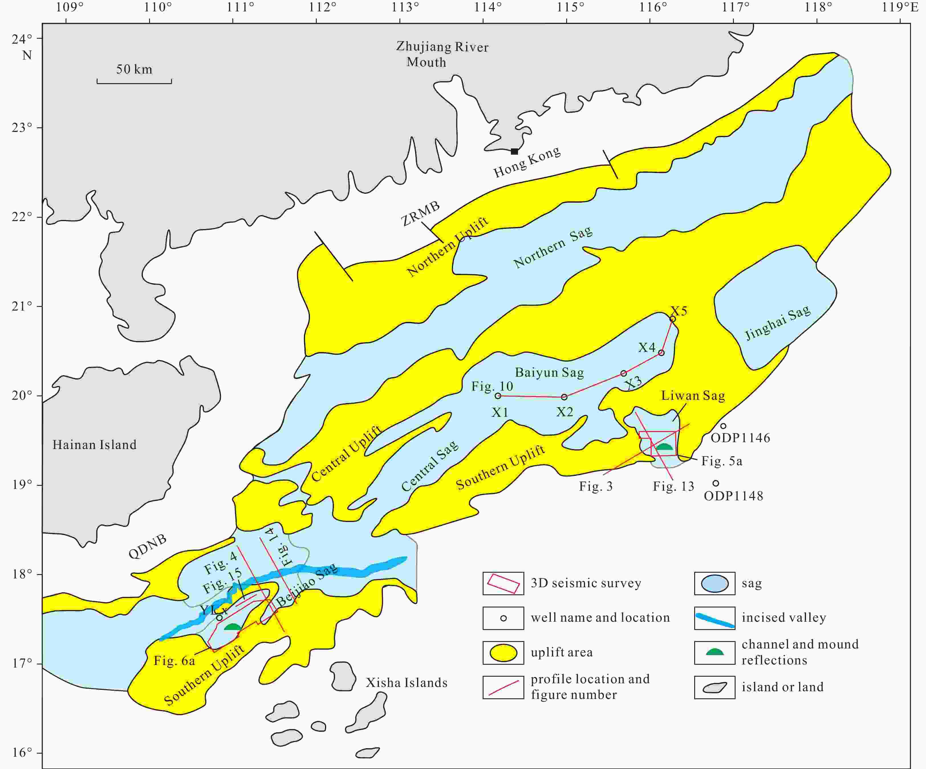
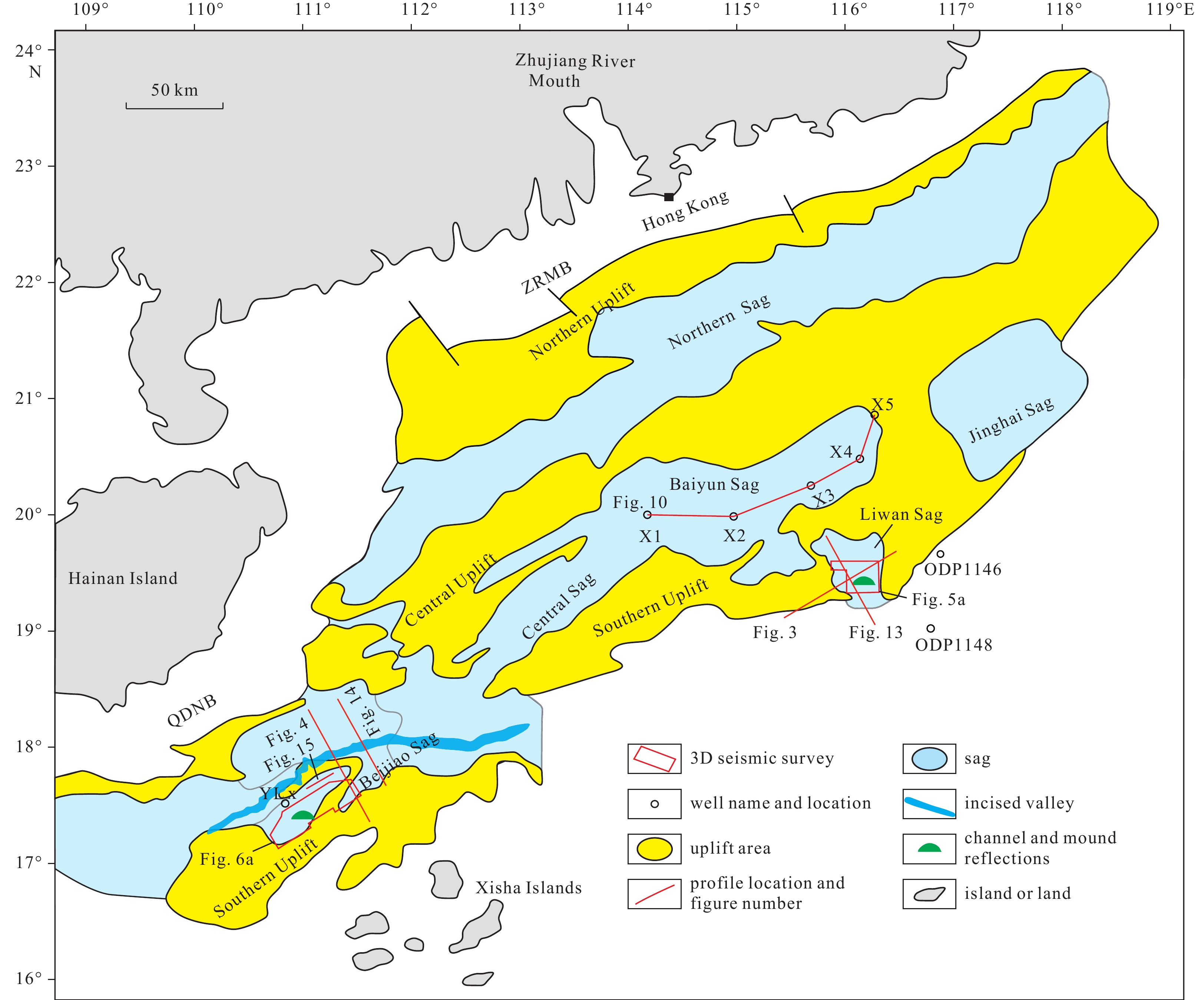
Figure 2. Tectonic units in the ZRMB-QDNB and the locations of the middle Miocene channel and mound reflections.
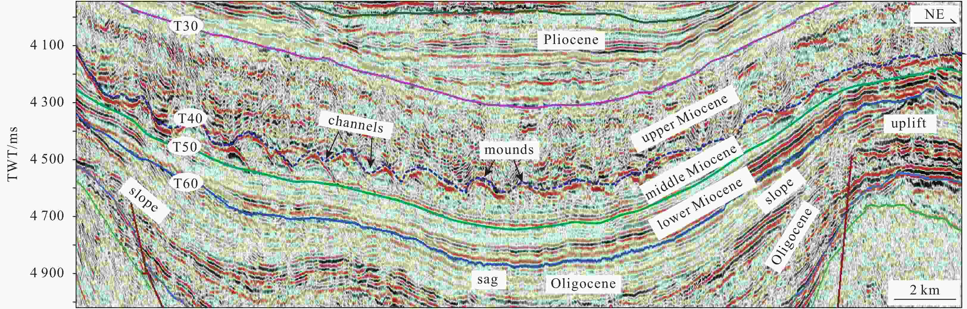
Figure 3. Characteristics of the mounds at the top of the middle Miocene in the Liwan Sag, ZRMB. The mounds are distributed on the slope and central sag. The bottom of channels between mounds exhibits relatively high amplitudes. The profile location is shown in Fig. 2. TWT: two-way-travel time.
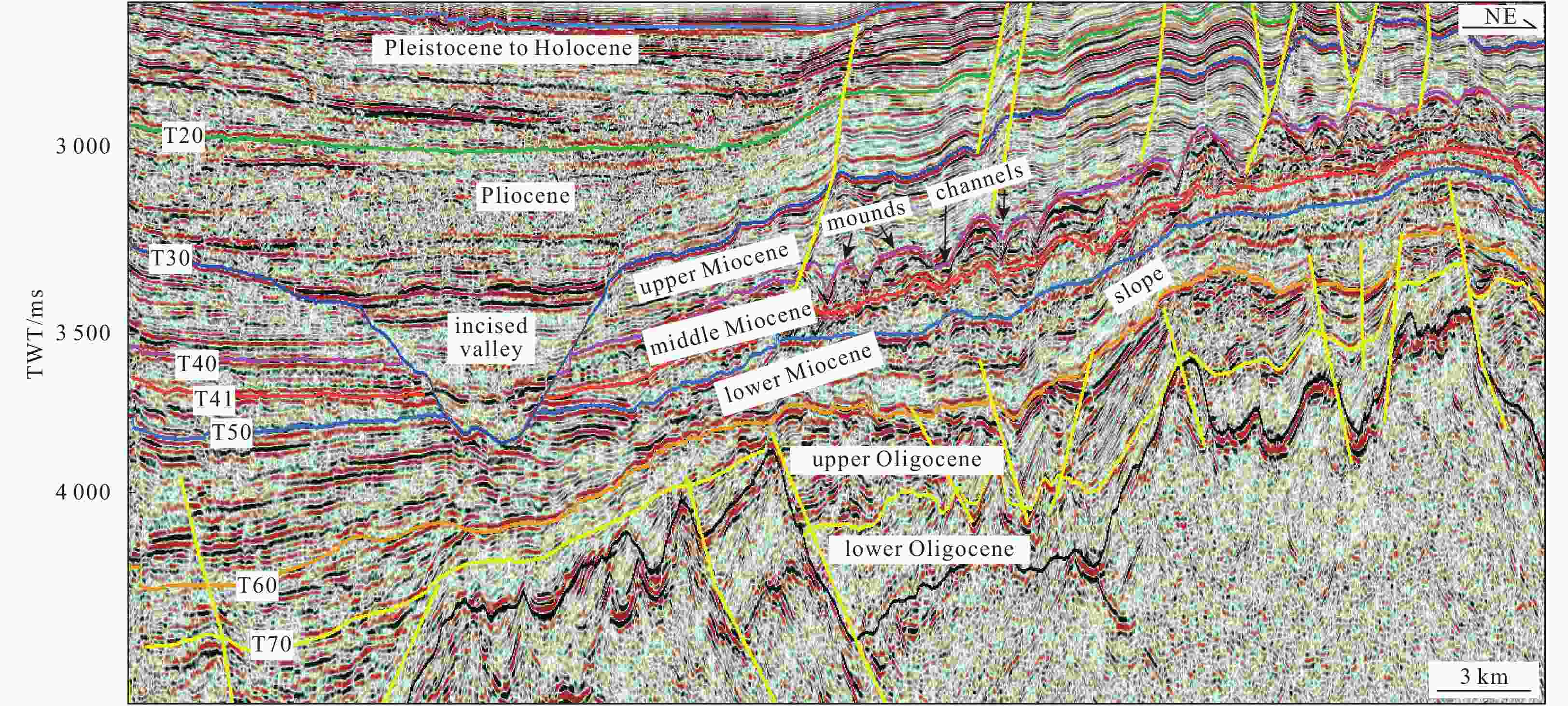
Figure 4. The middle Miocene mounds are distributed in the slope of the Beijiao Sag, QDNB. The profile location is shown in Fig. 2.

Figure 5. The characteristics of Miocene channels and mounds in the 3D seismic survey in the Liwan Sag, ZRMB. a. The isochronous map of the remnant mounds (T40−T41); b. the mean-square-root (RMS) amplitude map of time window from the channel bottom T40 to 30 ms upward; c. a north-south 3D seismic profile perpendicular to the channels; d. a near east-west seismic profile along the channels.
6. The characteristics of RMS amplitude maps for channels (a) and mounds (b), the time thickness map (c) and profile of mounds (d, e) in the Beijiao 3D seismic survey. The amplitude of upper Miocene channels is high to mediate-low from the southwestern to northeastern Qiongdongnan Basin, respectively; the mounds between channels are characterized by low amplitudes.
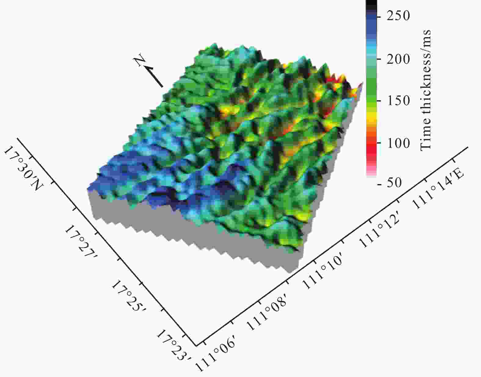
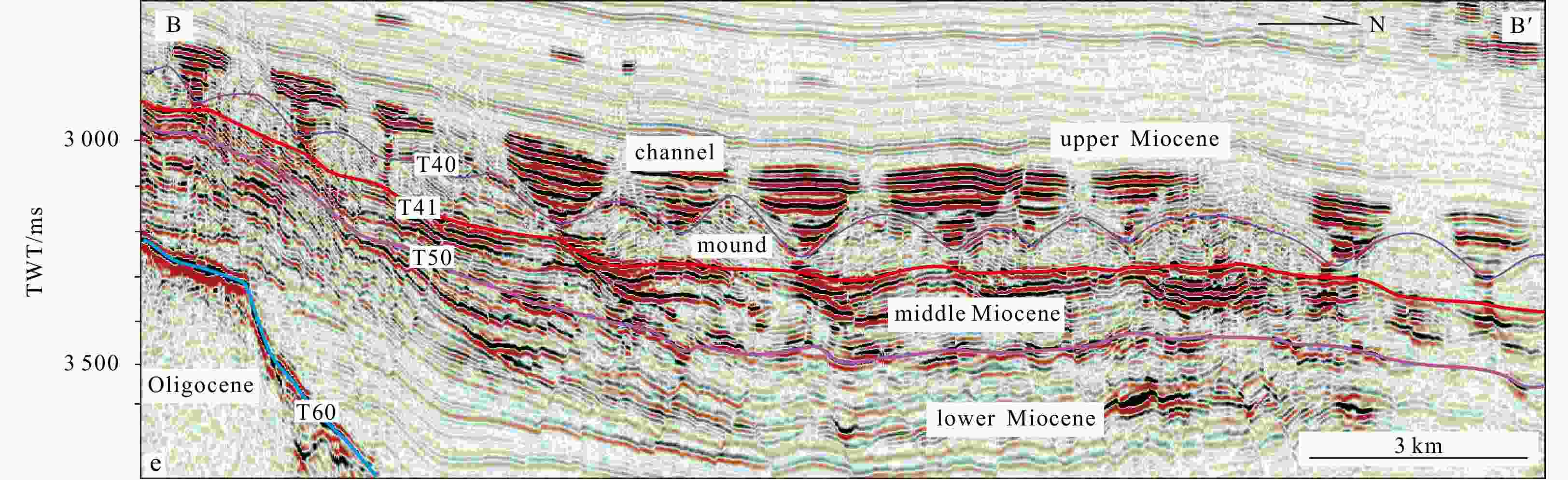
Figure 7. Time thickness map at the centre of the Beijiao Sag (T40–T41), showing the middle Miocene mounded reflections extending in a near east-west direction as parallel lines. See Fig. 6c for the location.

Figure 8. Horizontal distribution (a) and three types (b and c) of internal structures of mound reflections in the Beijiao Sag. Polygonal faults are developed within the mounds (Li et al., 2017a), to some extent, which disturb the discipline of the three types mounds and make seismic reflections within mounds unclear.
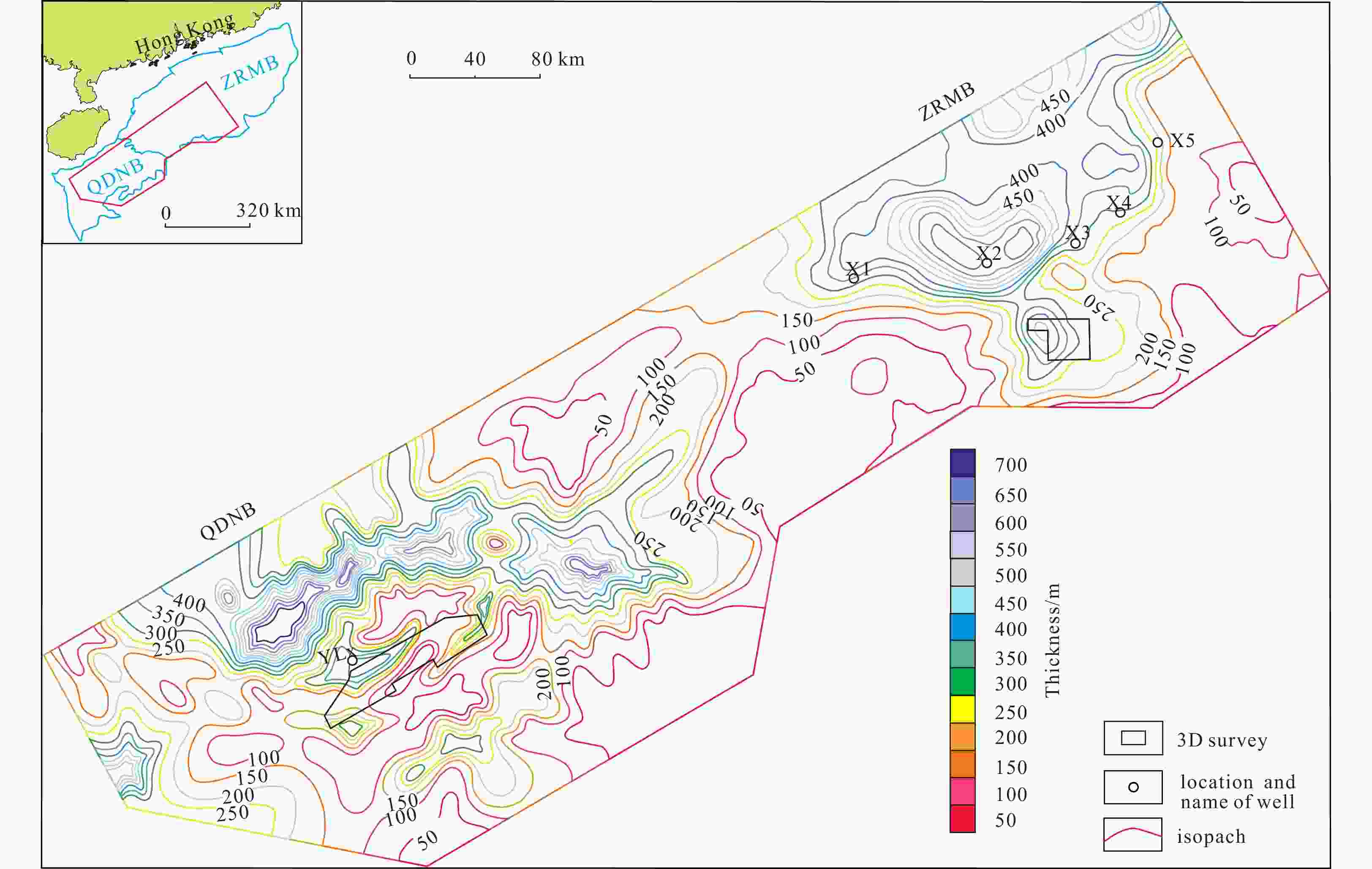
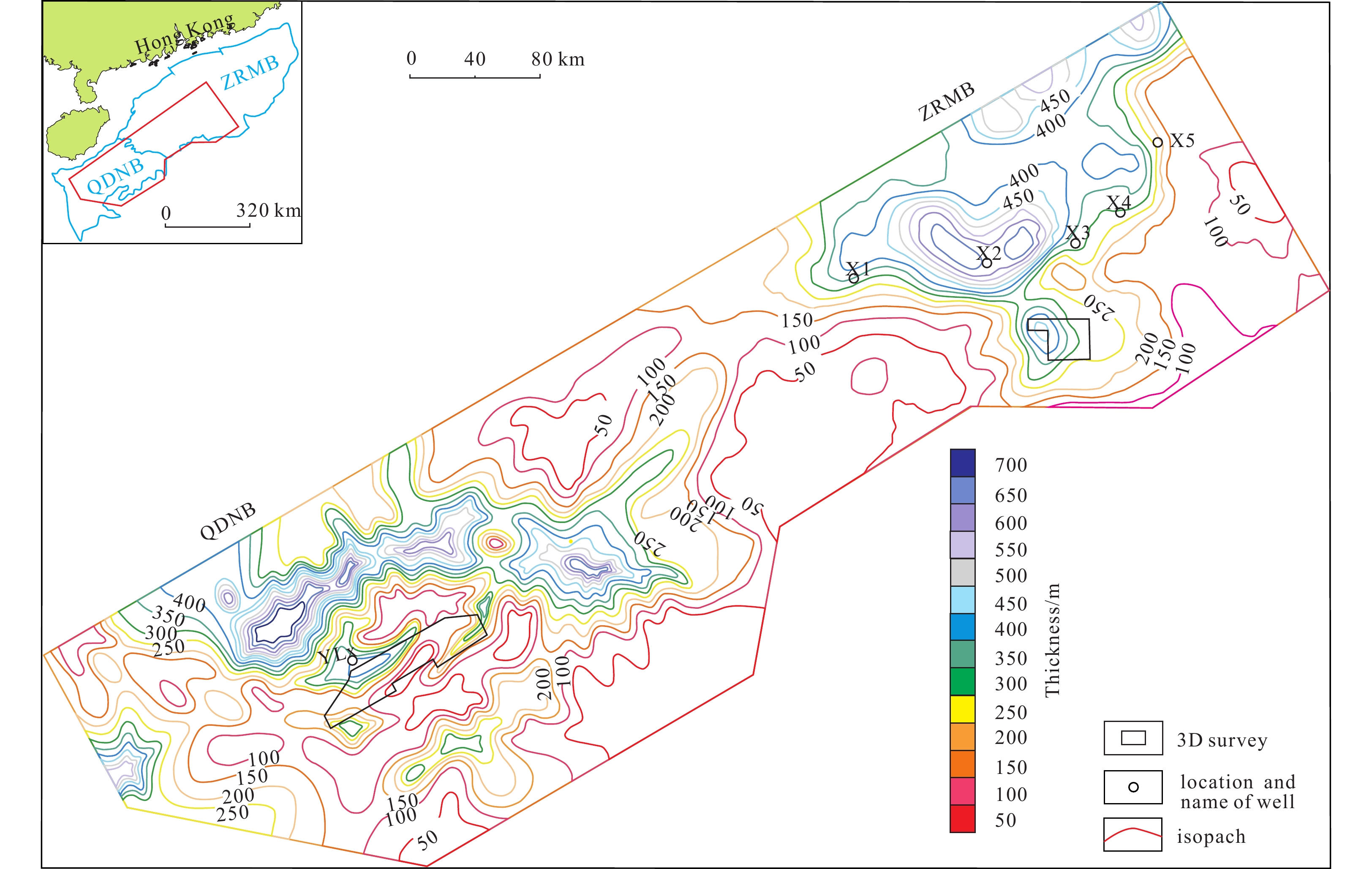
Figure 9. Isopach map of the ZRMB-QDNB (T50−T40), indicating that both Beijiao Sag and Liwan Sag with channels and mounds reflections are located in the tectonic depression with relatively thick sediments.

Figure 10. The comparative section of sedimentary facies for connecting wells of the middle and lower Miocene in the ZRMB. The section location is shown in Figs 2 and 11. GR: natural gamma ray, RILD: resistivity of deep investigate induction log, SP: spontaneous potential, AC: acoustic, RT: true formation resistivity, RD: deep investigate double lateral resistivity log.
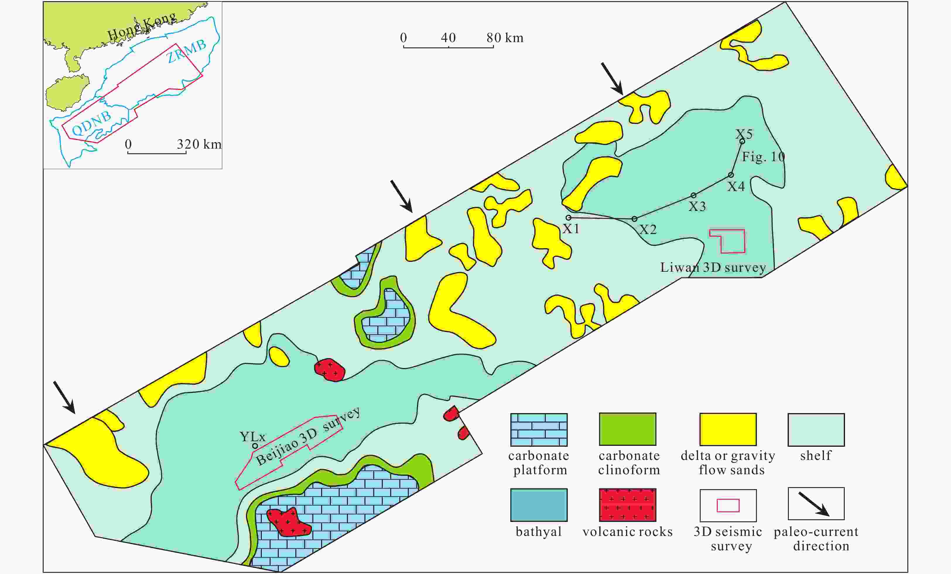
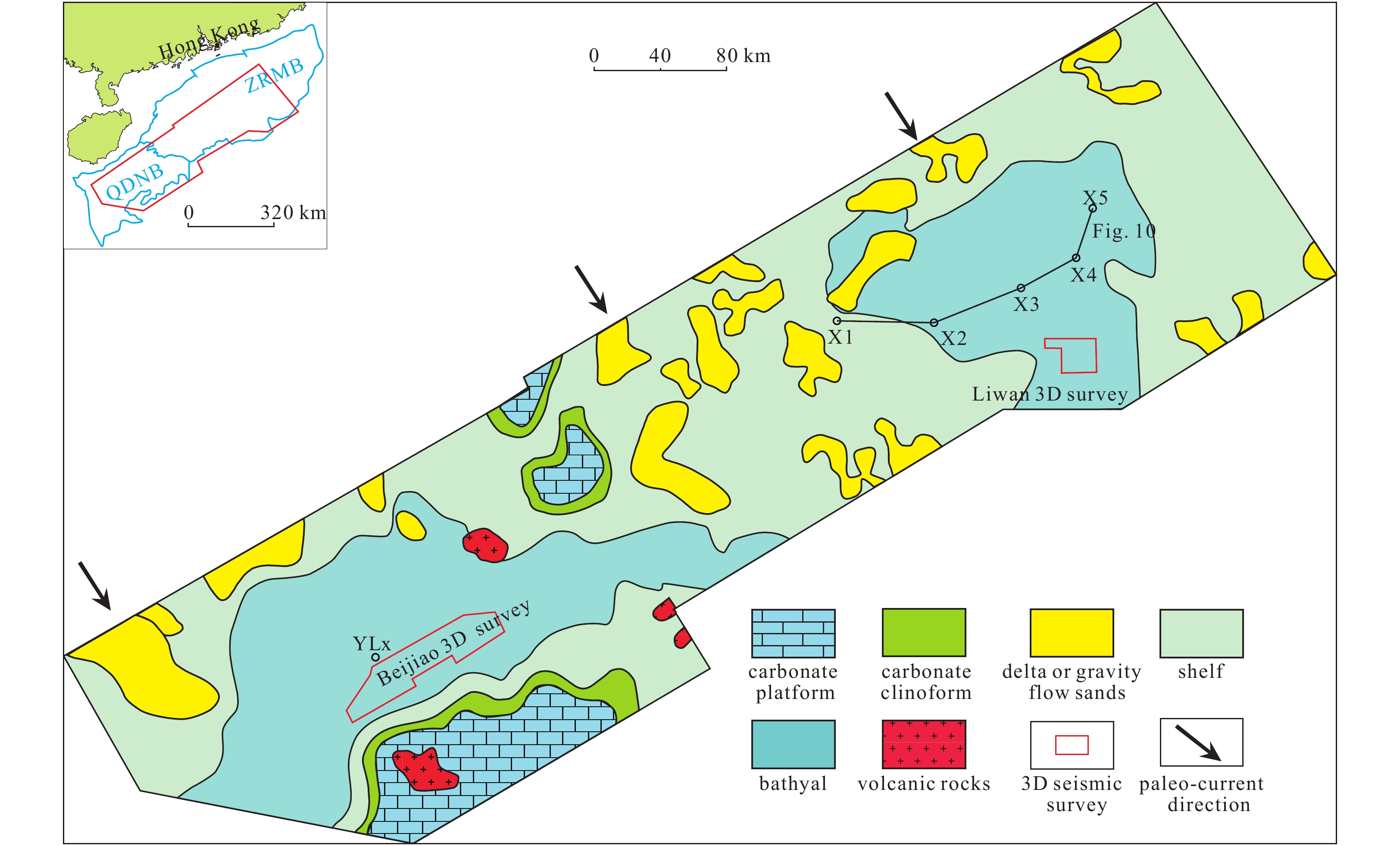
Figure 11. Middle Miocene (T50−T40) sedimentary facies map of the ZRMB and QDNB, indicating that the channels and mounds are developed in the bathyal environment.
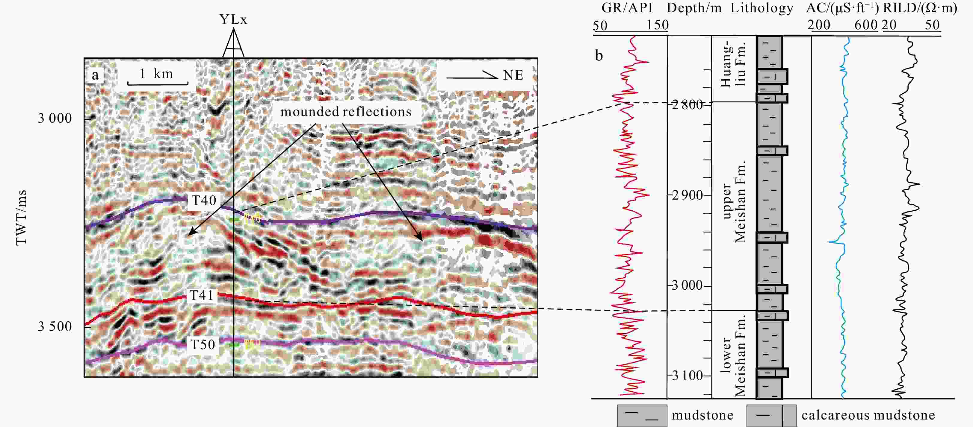
Figure 12. Well YLx logging and lithology profiles corresponding to the mound reflections in the Meishan Fm. in the Beijiao Sag of the Qiongdongnan Basin. Fm.: represents formation.
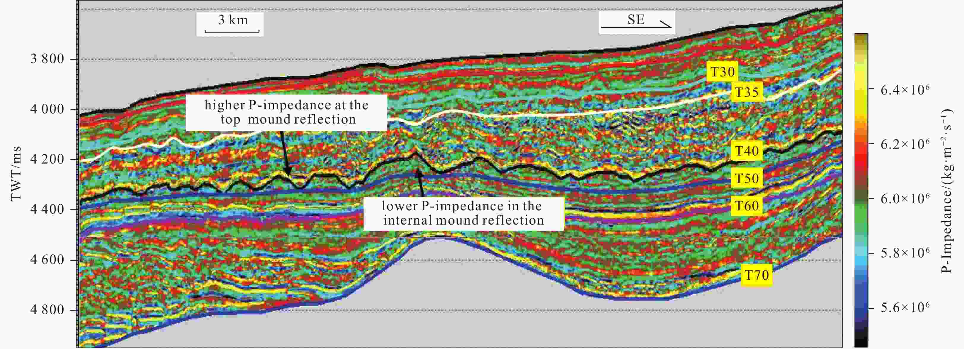
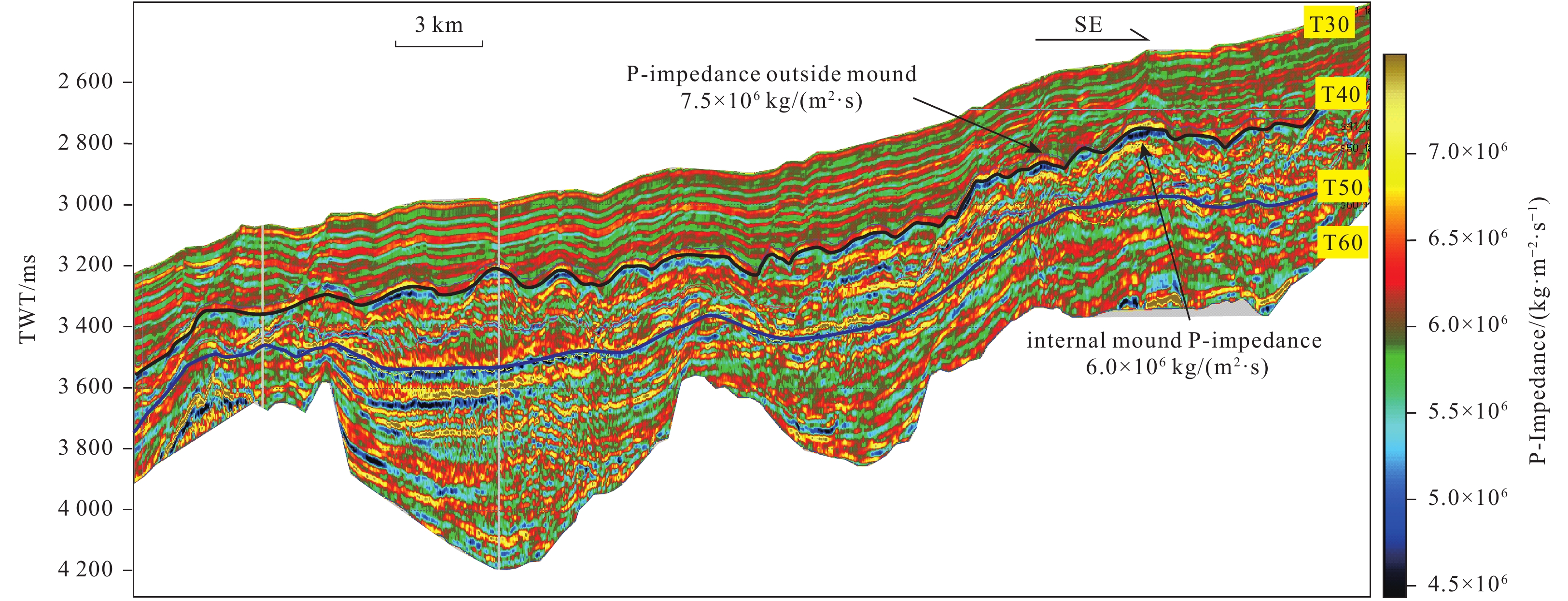
Figure 13. The wave impedance profile for the Liwan Sag. The average value for the wave impedance of mounds is less than 6.5×10⁶ kg/(m2∙s). Location is shown in Fig. 2.

Figure 14. The wave impedance profile for the Beijiao Sag. The average value for the wave impedance of mounds is less than 6.0×10⁶ kg/(m2∙s). Location is shown in Fig. 2.

Figure 15. The migration characteristics of bottom-current sediment waves. It shows crests and troughs of sediment waves have migrated southwestward since the early late Miocene, which suggests that bottom currents persistently move northeastwards in the early late Miocene. Green and blue solid arrows represent unidirectional migration of crests and troughs of sediment waves, respectively. See location in Fig. 2.

Figure 16. Seismic profile showing seismic contact characteristics among mounds, channels and polygonal faults. Blue and dark blue dots stand for truncations and onlaps, respectively. See locations in Fig. 6a.
Table 1. Absolute ages and basin evolution stages corresponding to the Miocene channels and mounds in the deep-water area in the ZRMB-QDNB (modified from Zhang et al. (2009) and Zhang (2010))
Stratigraphy Lithological stratigraphy
of QDNBLithological stratigraphy
of ZRMBAge
/MaSeismic
horizonErathem era System period Series epoch Cenozoic Quaternary Pleistocene Ledong Fm. Wanshan Fm. 1.9 T20 Pliocene Yinggehai Fm. Aohai Fm. 5.5 T30 Neogene Miocene upper Huangliu Fm. Hanjiang Fm. 11.6 T40 middle Meishan Fm. Zhujiang Fm. 13.8 T41 lower Sanya Fm. Zhuhai Fm. 15.5 T50 Oligocene upper Lingshui Fm. Enping Fm. 23.3 T60 lower Yacheng Fm. Wenchang Fm. 29.3 T70 Paleogene Eocene Lingtou Fm. Shenhu Fm. 32.0 T80 pre-Cenozoic – – – 53.5 Tg Note: – represents no data.  下载: 导出CSV
-
[1] Andresen K J, Clausen O R, Huuse M. 2009. A giant (5.3×10⁷ m3) middle Miocene (c. 15 Ma) sediment mound (M1) above the Siri Canyon, Norwegian–Danish Basin: Origin and significance. Marine and Petroleum Geology, 26(8): 1640–1655. doi: 10.1016/j.marpetgeo.2009.02.005 [2] Bull S, Cartwright J, Huuse M. 2009. A review of kinematic indicators from mass-transport complexes using 3D seismic data. Marine and Petroleum Geology, 26(7): 1132–1151. doi: 10.1016/j.marpetgeo.2008.09.011 [3] Chen C T A, Wang Shulun. 1998. Influence of intermediate water in the western Okinawa Trough by the outflow from the South China Sea. Journal of Geophysical Research, 103(C6): 12683–12688. doi: 10.1029/98JC00366 [4] Chen Hui, Xie Xinong, Van Rooij D, et al. 2013. Depositional characteristics and spatial distribution of deep-water sedimentary systems on the northwestern middle-lower slope of the Northwest Sub-Basin, South China Sea. Marine Geophysical Research, 34(3–4): 239–257. doi: 10.1007/s11001-013-9191-7 [5] Chen Hui, Xie Xinong, Van Rooij D, et al. 2014. Depositional characteristics and processes of alongslope currents related to a seamount on the northwestern margin of the Northwest Sub-Basin, South China Sea. Marine Geology, 355: 36–53. doi: 10.1016/j.margeo.2014.05.008 [6] Chen Hui, Xie Xinong, Zhang Wenyan, et al. 2016. Deep-water sedimentary systems and their relationship with bottom currents at the intersection of Xisha trough and Northwest Sub-Basin, South China Sea. Marine Geology, 378: 101–113. doi: 10.1016/j.margeo.2015.11.002 [7] Chen Jiangxin, Song Haibin, Guan Yongxian, et al. 2015. Morphologies, classification and genesis of pockmarks, mud volcanoes and associated fluid escape features in the northern Zhongjiannan Basin, South China Sea. Deep Sea Research Part Ⅱ: Topical Studies in Oceanography, 122: 106–117. doi: 10.1016/j.dsr2.2015.11.007 [8] Chen Lei, Lu Yongchao, Wang Zhenfeng, et al. 2011. Structure of carbonate platform margin and characteristics of reef and their controlling factors in western deep-water region of South China Sea. Petroleum Geology and Experiment (in Chinese), 33(6): 607–612 [9] Dercourt J, Gaetani M, Vrielynck B, et al. 2000. Atlas Peri-Tethys: Palaeogeographical Maps. Paris, France: Commission for the Geological Map of the World, 268. [10] Duque-Caro H. 1990. Neogene stratigraphy, paleoceanography and paleobiogeography in Northwest South America and the evolution of the Panama Seaway. Palaeogeography, Palaeoclimatology, Palaeoecology, 77(3–4): 203–234. doi: 10.1016/0031-0182(90)90178-A [11] Flood R D. 1988. A lee wave model for deep-sea mudwave activity. Deep Sea Research, 35(6): 973–983. doi: 10.1016/0198-0149(88)90071-4 [12] Flood R D, Giosan L. 2002. Migration history of a fine-grained abyssal sediment wave on the Bahama Outer Ridge. Marine Geology, 192(1-3): 259–273. doi: 10.1016/S0025-3227(02)00558-3 [13] Gong Chenglin, Wang Yingmin, Peng Xuechao, et al. 2012. Sediment waves on the South China Sea Slope off southwestern Taiwan: Implications for the intrusion of the Northern Pacific Deep Water into the South China Sea. Marine and Petroleum Geology, 32(1): 95–109. doi: 10.1016/j.marpetgeo.2011.12.005 [14] Gong Chenglin, Wang Yingmin, Zheng Rongcai, et al. 2016. Middle Miocene reworked turbidites in the Baiyun Sag of the Pearl River Mouth Basin, northern South China Sea margin: Flow processes, genesis, and implications. Journal of Asian Earth Sciences, 128: 116–129. doi: 10.1016/j.jseaes.2016.06.025 [15] He Yunlong, Xie Xinong, Kneller B C, et al. 2013. Architecture and controlling factors of canyon fills on the shelf margin in the Qiongdongnan Basin, northern South China Sea. Marine and Petroleum Geology, 41: 264–276. doi: 10.1016/j.marpetgeo.2012.03.002 [16] Hernández-Molina F J, Campbell S, Badalini G, et al. 2017. Large bedforms on contourite terraces: Sedimentary and conceptual implications. Geology, 46(1): 27–30 [17] Huang Hongguang, Lu Yongchao, Zou Zhuochao. 2012. Application of seismic sedimentology in platform edge reef, Songnan 3D area, Qiongdongnan Basin. Petroleum Geology & Experiment (in Chinese), 34(1): 25–29 [18] Jiang Tao, Xie Xinong, Wang Zhenfeng, et al. 2013. Seismic features and origin of sediment waves in the Qiongdongnan Basin, northern South China Sea. Marine Geophysical Research, 34(3-4): 281–294. doi: 10.1007/s11001-013-9198-0 [19] Keigwin L. 1982. Isotopic paleoceanography of the Caribbean and east Pacific: Role of Panama uplift in late Neogene time. Science, 217(4557): 350–352. doi: 10.1126/science.217.4557.350 [20] Kuhnt W, Holbourn A, Hall R, et al. 2004. Neogene history of the Indonesian throughflow. In: Clift P, Kuhnt W, Wang Pinxian, Hayes D, eds. Continent-Ocean Interactions within East Asian Marginal Seas. Washington, DC, USA: American Geophysical Union, 299–320. [21] Li Hu, Wang Yingmin, Zhu Weilin, et al. 2013. Seismic characteristics and processes of the Plio-Quaternary unidirectionally migrating channels and contourites in the northern slope of the South China Sea. Marine and Petroleum Geology, 43: 370–380. doi: 10.1016/j.marpetgeo.2012.12.010 [22] Li Yufeng, Pu Renhai, Fan Xiaowei, et al. 2017a. Characteristics and genesis of the polygonal fault system in Beijiao Sag of the Qiongdongnan Basin, the Northern South China Sea. Geotectonica et Metallogenia (in Chinese), 41(5): 817–828 [23] Li Yufeng, Pu Renhai, Qu Hongjun, et al. 2017b. The characteristics and genesis analysis of the mound at the top of Meishan Formation in the Beijiao Sag of the Qiongdongnan Basin. Haiyang Xuebao (in Chinese), 39(5): 89–102 [24] Li Yufeng, Pu Renhai, Qu Hongjun, et al. 2018. Distribution of bottom current channels and mounds controlled by Paleo-Morphology in Mid-Miocene in Beijiao Sag of Qiongdongnan Basin. Geological Science and Technology Information (in Chinese), 37(2): 1–8 [25] Liao Jihua, Xu Qiang, Chen Ying, et al. 2016. Sedimentary characteristics and genesis of the deepwater channel system in Zhujiang Formation of Baiyun-Liwan Sag. Earth Science (in Chinese), 41(6): 1041–1054 [26] Liu Siqing, Zhang Cuimei, Sun Zhen, et al. 2016. Characteristics and significances of the geological boundary SB21 in the Zhujiang Formation of the Liwan Sag, Pearl River Mouth Basin. Earth Science (in Chinese), 41(3): 475–486 [27] Ma Yubo, Wu Shiguo, Gu Mingfeng, et al. 2010. Seismic reflection characteristics and depositional model of carbonate platforms in Xisha sea area. Haiyang Xuebao (in Chinese), 32(4): 118–128 [28] Masson D G, Harbitz C B, Wynn R B, et al. 2006. Submarine landslides: processes, triggers and hazard prediction. Philosophical Transactions of the Royal Society A Mathematical Physical and Engineering Sciences, 364(1845): 2009–2039. doi: 10.1098/rsta.2006.1810 [29] Meng Xiangjun, Zhang Xunhua, Han Bo, et al. 2012. The geophysical characteristics of submarine mud volcano. Marine Geology Frontiers (in Chinese), 28(12): 6–9, 45 [30] Pu Renhai, Zhong Hongli, Zhang Yunlong. 2013. Preliminary study on the effects of Permian volcanism on the Tahe Ordovician oil pools in Tarim Basin. Marine and Petroleum Geology, 44: 13–20. doi: 10.1016/j.marpetgeo.2013.03.003 [31] Ru K, Pigott J D. 1986. Episodic rifting and subsidence in the South China Sea. AAPG Bulletin, 70(9): 1136–1155 [32] Shao Lei, Cui Yuchi, Qiao Peijun, et al. 2017. Sea-level changes and carbonate platform evolution of the Xisha Islands (South China Sea) since the early Miocene. Palaeogeography, Palaeoclimatology, Palaeoecology, 485: 504–516. doi: 10.1016/j.palaeo.2017.07.006 [33] Shao Lei, Li Xuejie, Geng Jianhua, et al. 2007. Deep water bottom current deposition in the northern South China Sea. Science in China Series D: Earth Sciences, 50(7): 1060–1066. doi: 10.1007/s11430-007-0015-y [34] Stow Dorrik A V, Armishaw Julie E, Holmes Richard. 2002. Holocene contourite sand sheet on the Barra Fan slope, NW Hebridean margin. Geological Society London Memoirs, 22(1): 99–119. doi: 10.1144/GSL.MEM.2002.022.01.09 [35] Stuart J Y, Huuse M. 2012. 3D seismic geomorphology of a large Plio-Pleistocene delta—‘Bright spots’ and contourites in the Southern North Sea. Marine and Petroleum Geology, 38(1): 143–157. doi: 10.1016/j.marpetgeo.2012.06.003 [36] Sun Qiliang, Cartwright J, Lüdmann T, et al. 2017. Three-dimensional seismic characterization of a complex sediment drift in the South China Sea: Evidence for unsteady flow regime. Sedimentology, 64(3): 832–853. doi: 10.1111/sed.12330 [37] Sun Qiliang, Cartwright J, Wu Shiguo, et al. 2016. Submarine erosional troughs in the northern South China Sea: Evidence for Early Miocene deepwater circulation and paleoceanographic change. Marine and Petroleum Geology, 77: 75–91. doi: 10.1016/j.marpetgeo.2016.06.005 [38] Tian Jie, Wu Shiguo, Lv Fuliang, et al. 2015. Middle Miocene mound-shaped sediment packages on the slope of the Xisha carbonate platforms, South China Sea: Combined result of gravity flow and bottom current. Deep Sea Research Part Ⅱ: Topical Studies in Oceanography, 122(2015): 172–184 [39] Tsuchi R. 1997. Marine climatic responses to Neogene tectonics of the Pacific Ocean seaways. Tectonophysics, 281(1–2): 113–124. doi: 10.1016/S0040-1951(97)00163-7 [40] Wang Chao, Lu Yongchao, Du Xuebin, et al. 2015. Developmental pattern and genetic background of carbonate platform margin reef complexes in deep-water area in western South China Sea. Oil Geophysical Prospecting (in Chinese), 50(6): 1179–1189 [41] Wilson J L. 1975. Carbonate Facies in Geologic History. New York: Springer-Verlag Press, 451–471. [42] Wu Shiguo, Yang Zhen, Wang Dawei, et al. 2014. Architecture, development and geological control of the Xisha carbonate platforms, northwestern South China Sea. Marine Geology, 350: 71–83. doi: 10.1016/j.margeo.2013.12.016 [43] Wu Shiguo, Yuan Shengqiang, Zhang Gongcheng, et al. 2009. Seismic characteristics of a reef carbonate reservoir and implications for hydrocarbon exploration in deepwater of the Qiongdongnan Basin, northern South China Sea. Marine and Petroleum Geology, 26(6): 817–823. doi: 10.1016/j.marpetgeo.2008.04.008 [44] Xie Xinong, Müller R D, Li Sitian, et al. 2006. Origin of anomalous subsidence along the northern south china sea margin and its relationship to dynamic topography. Marine and Petroleum Geology, 23(7): 745–765. doi: 10.1016/j.marpetgeo.2006.03.004 [45] Xue Huijie, Chai Fei, Neal Pettigrew, et al. 2004. Kuroshio intrusion and the circulation in the South China Sea. Journal of Geophysical Research, 109(C2): C02017 [46] Yang Bo, Zhang Changmin, Li Shaohua, et al. 2014. Seismic facies analysis and geological interpretation of large-scale mounds in Pearl River Mouth Basin. Acta Petrolei Sinica (in Chinese), 35(1): 37–49 [47] Yi Wanshun, Deng Yantao, Di Bangrang. 2012. Discussion on the genesis of domal reflections at the uplift zone of the southern Qiongdongnan Basin. Geophysical Prospecting for Petroleum (in Chinese), 51(2): 199–203 [48] Zhang Bin, Wang Pujun, Zhang Gongcheng, et al. 2013. Cenozoic volcanic rocks in the Pearl River Mouth and Southeast Hainan Basins of South China Sea and their implications for petroleum geology. Petroleum Exploration and Development, 40(6): 704–713. doi: 10.1016/S1876-3804(13)60095-6 [49] Zhang Gongcheng. 2010. Tectonic evolution of deepwater area of northern continental margin in South China Sea. Acta Petrolei Sinica (in Chinese), 31(4): 528–533, 541 [50] Zhang Gongcheng, Liu Zhen, Mi Lijun, et al. 2009. Sedimentary evolution of Paleogene series in deep water area of Zhujiangkou and Qiongdongnan Basin. Acta Sedimentologica Sinica (in Chinese), 27(4): 632–641 [51] Zhang Yonggui, Song Zaichao, Zhou Xiaojin, et al. 2011. Identification of reef in Miocene, South of Qiongdongnan Basin. Petroleum Geology & Experiment (in Chinese), 33(3): 307–309, 313 [52] Zhao Tianliang, Pu Renhai, Qu Hongjun, et al. 2013. An origin discussion of mound-shaped reflections in Miocene, southern Qiongdongnan Basin. Haiyang Xuebao (in Chinese), 35(4): 112–120 [53] Zhu Mangzheng, Graham S, Pang Xiong, et al. 2010. Characteristics of migrating submarine canyons from the middle Miocene to present: Implications for paleoceanographic circulation, northern South China Sea. Marine and Petroleum Geology, 27(1): 307–319. doi: 10.1016/j.marpetgeo.2009.05.005 -


 点击查看大图

计量
- 文章访问数: 528
- HTML全文浏览量: 198
- PDF下载量: 31
- 被引次数: 0

