

Automated multi-scale classification of the terrain units of the Jiaxie Guyots and their mineral resource characteristics
-
Abstract: Given the advances in satellite altimetry and multibeam bathymetry, benthic terrain classification based on digital bathymetric models (DBMs) has been widely used for the mapping of benthic topographies. For instance, cobalt-rich crusts (CRCs) are important mineral resources found on seamounts and guyots in the western Pacific Ocean. Thick, plate-like CRCs are known to form on the summit and slopes of seamounts at the 1 000–3 000 m depth, while the relationship between seamount topography and spatial distribution of CRCs remains unclear. The benthic terrain classification of seamounts can solve this problem, thereby, facilitating the rapid exploration of seamount CRCs. Our study used an EM122 multibeam echosounder to retrieve high-resolution bathymetry data in the CRCs contract license area of China, i.e., the Jiaxie Guyots in 2015 and 2016. Based on the DBM construted by bathymetirc data, broad- and fine-scale bathymetric position indices were utilized for quantitative classification of the terrain units of the Jiaxie Guyots on multiple scales. The classification revealed four first-order terrain units (e.g., flat, crest, slope, and depression) and eleven second-order terrain units (e.g., local crests, depressions on crests, gentle slopes, crests on slopes, and local depressions, etc.). Furthermore, the classification of the terrain and geological analysis indicated that the Weijia Guyot has a large flat summit, with local crests at the southern summit, whereas most of the guyot flanks were covered by gentle slopes. “Radial” mountain ridges have developed on the eastern side, while large-scale gravitational landslides have developed on the western and southern flanks. Additionally, landslide masses can be observed at the bottom of these slopes. The coverage of local crests on the seamount is ~1 000 km2, and the local crests on the peak and flanks of the guyots may be the areas where thick and continuous plate-like CRCs are likely to occur.
-
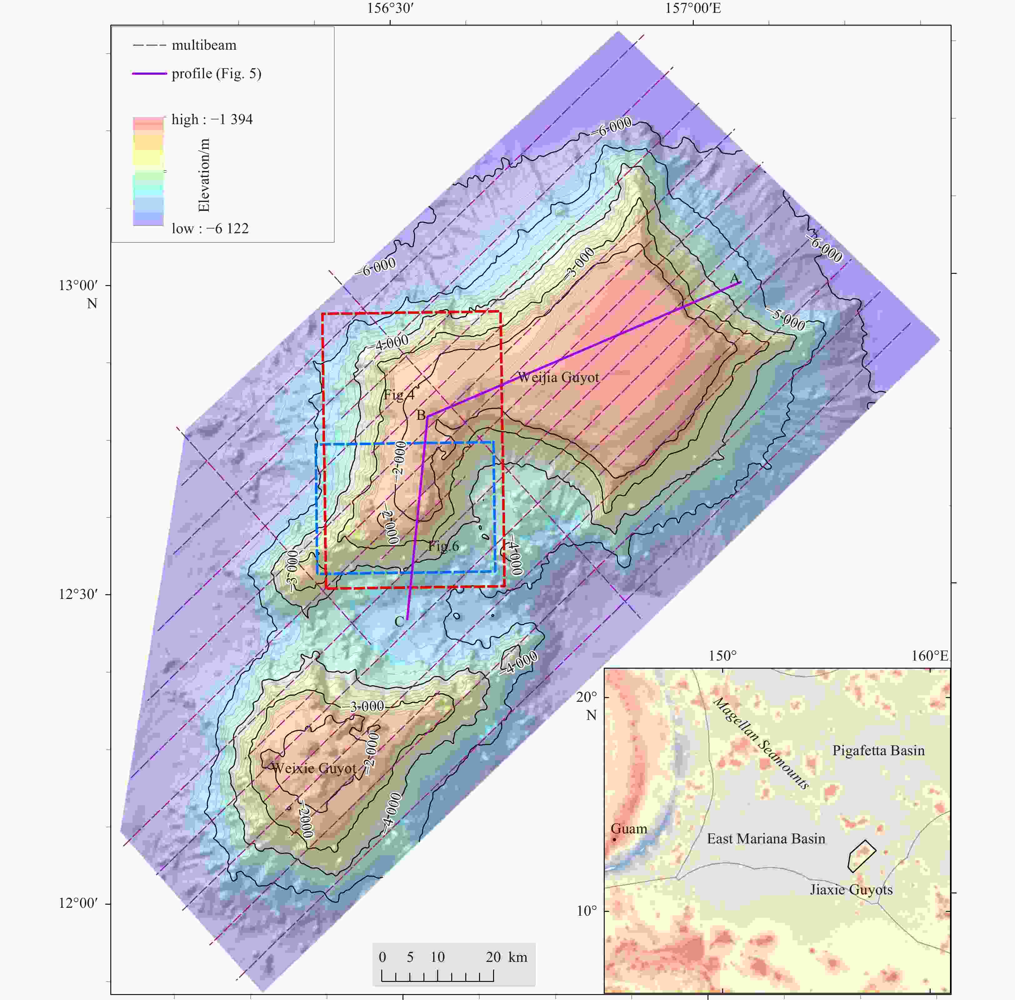
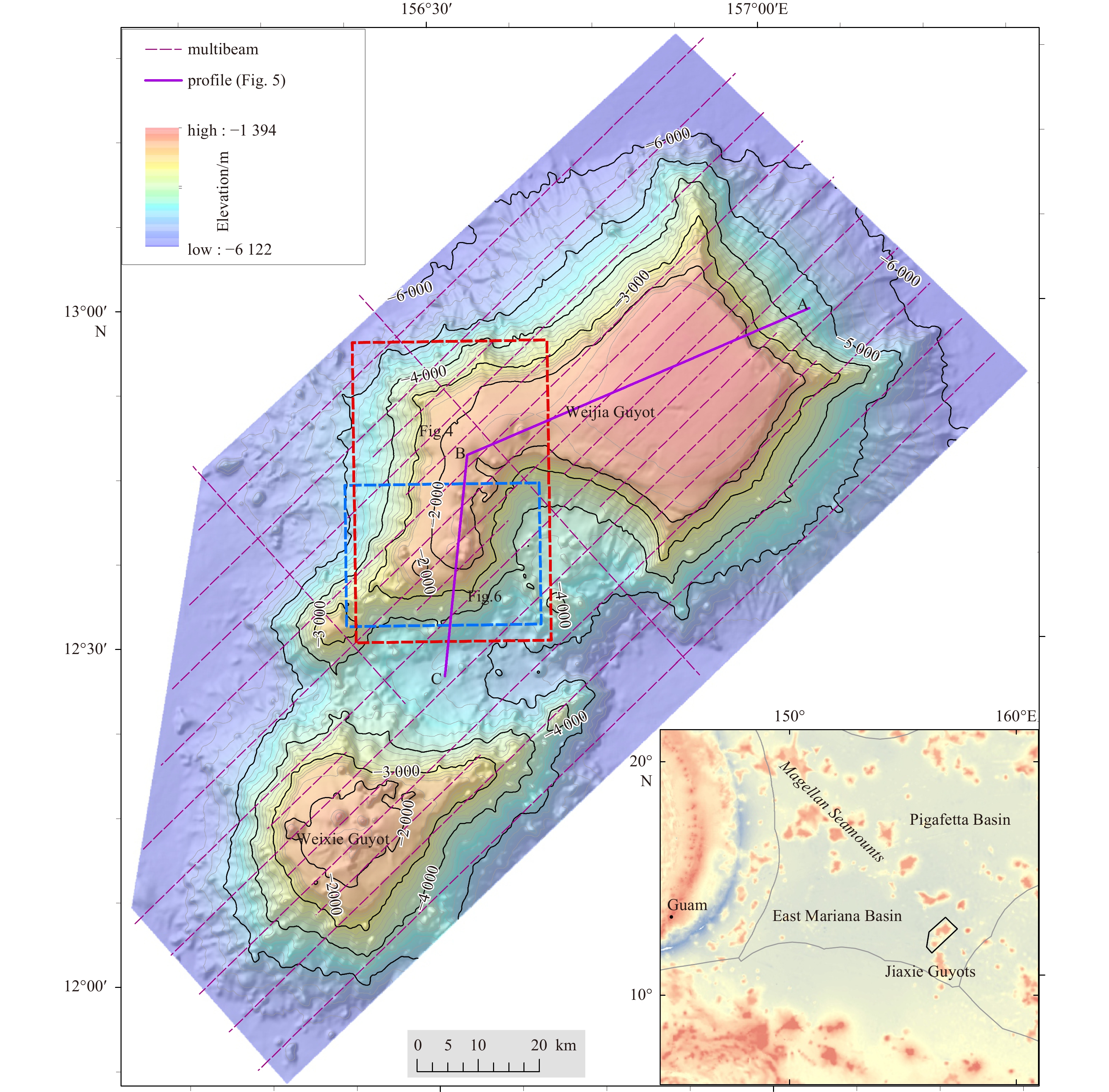
Figure 1. Seafloor terrain map of Jiaxie Guyots. The red and blue dashed boxes are ranges of Fig. 4 and Fig. 6, respectively.
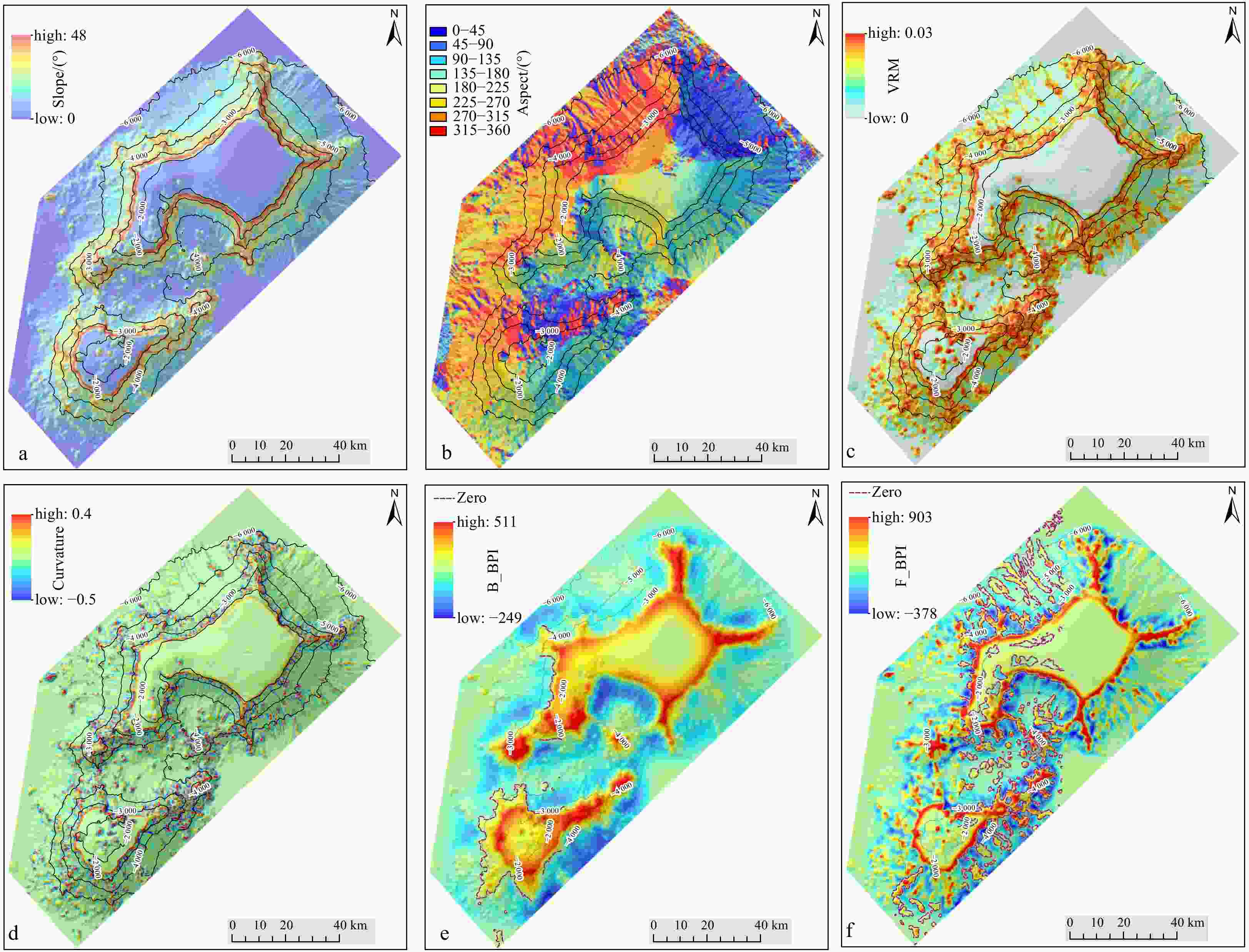
Figure 2. Terrain factors. a. Slope; b. aspect; c. vector ruggedness measure (VRM); d. curvature; e. broad-scale bathymetric position index (B_BPI); f. fine-scale bathymetric position index (F_BPI). The contour line is elevation.
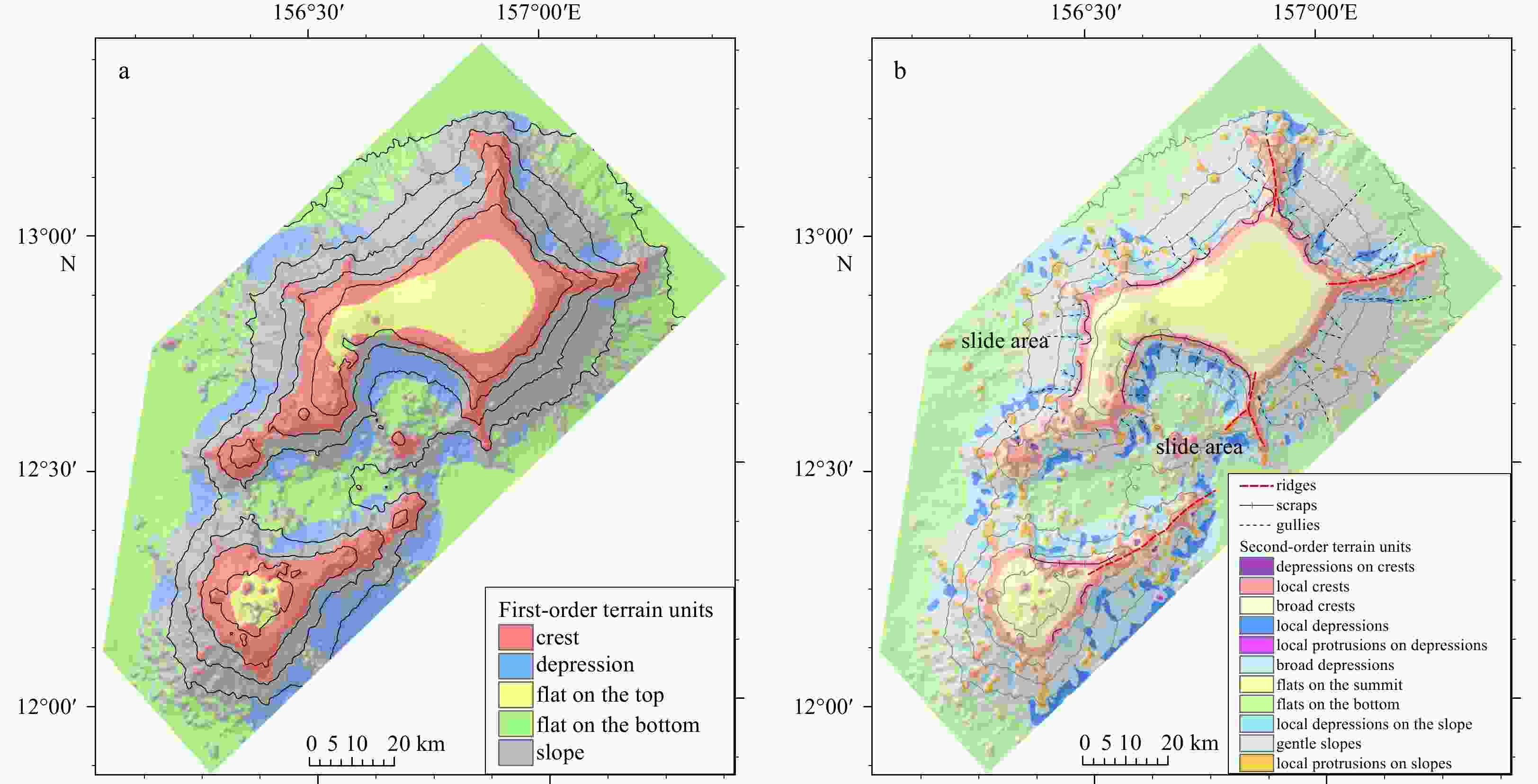
Figure 3. Result of seamount terrain units. a. First-order units; b. second-order units.
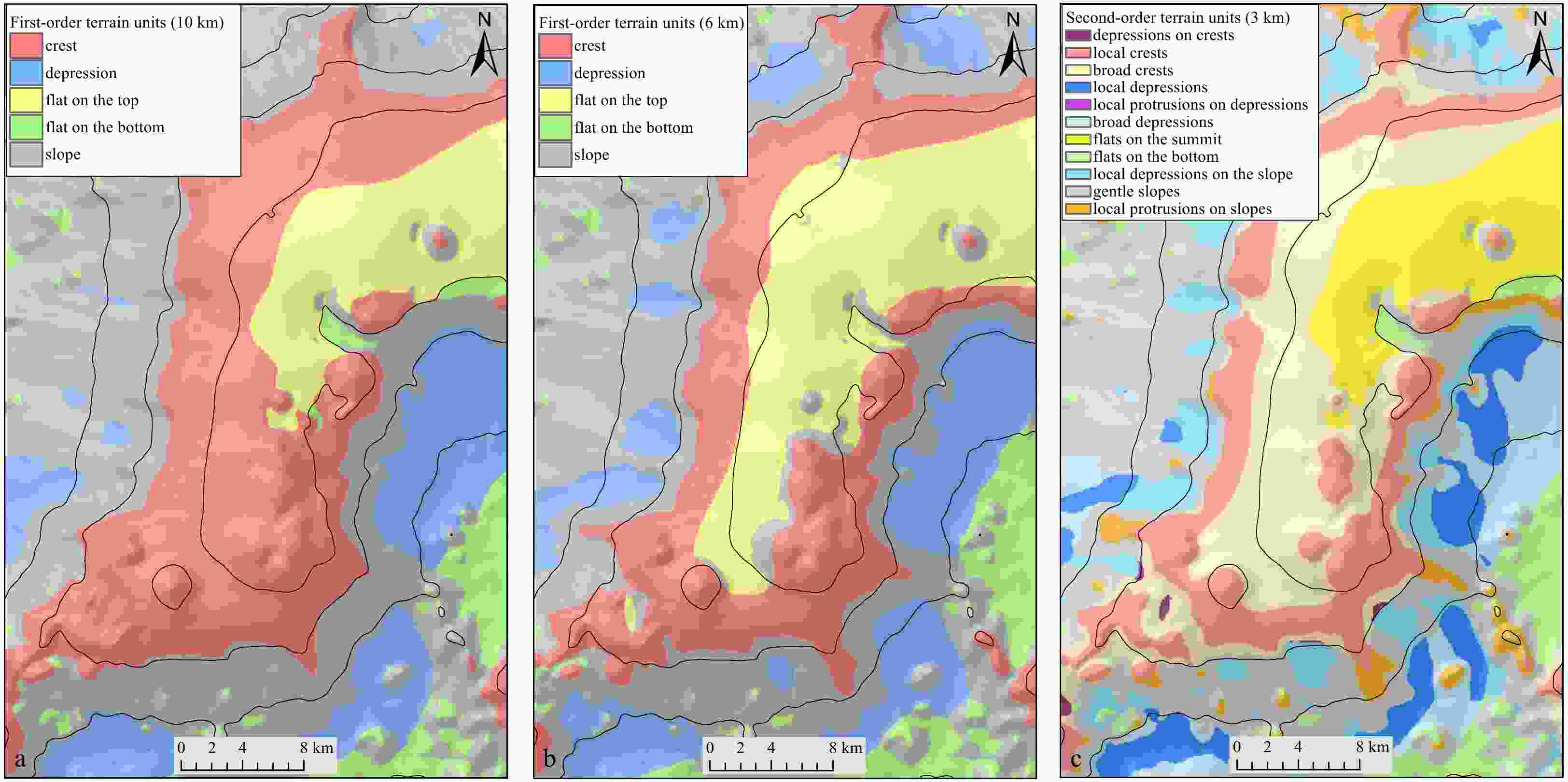
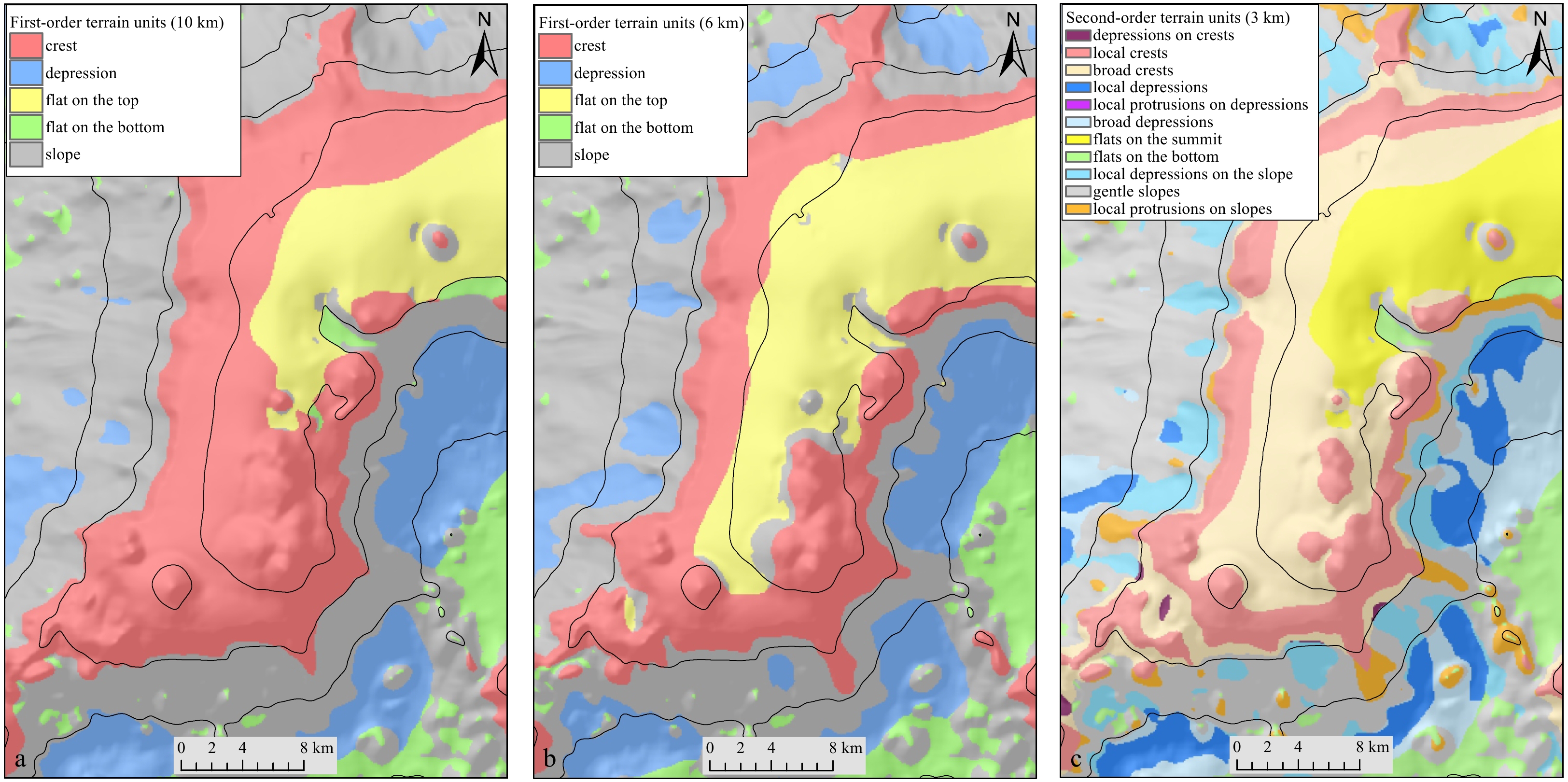
Figure 4. Multi-scale terrain analysis. a. First-order units (10 km); b. first-order units (6 km); c. second-order units (3 km).
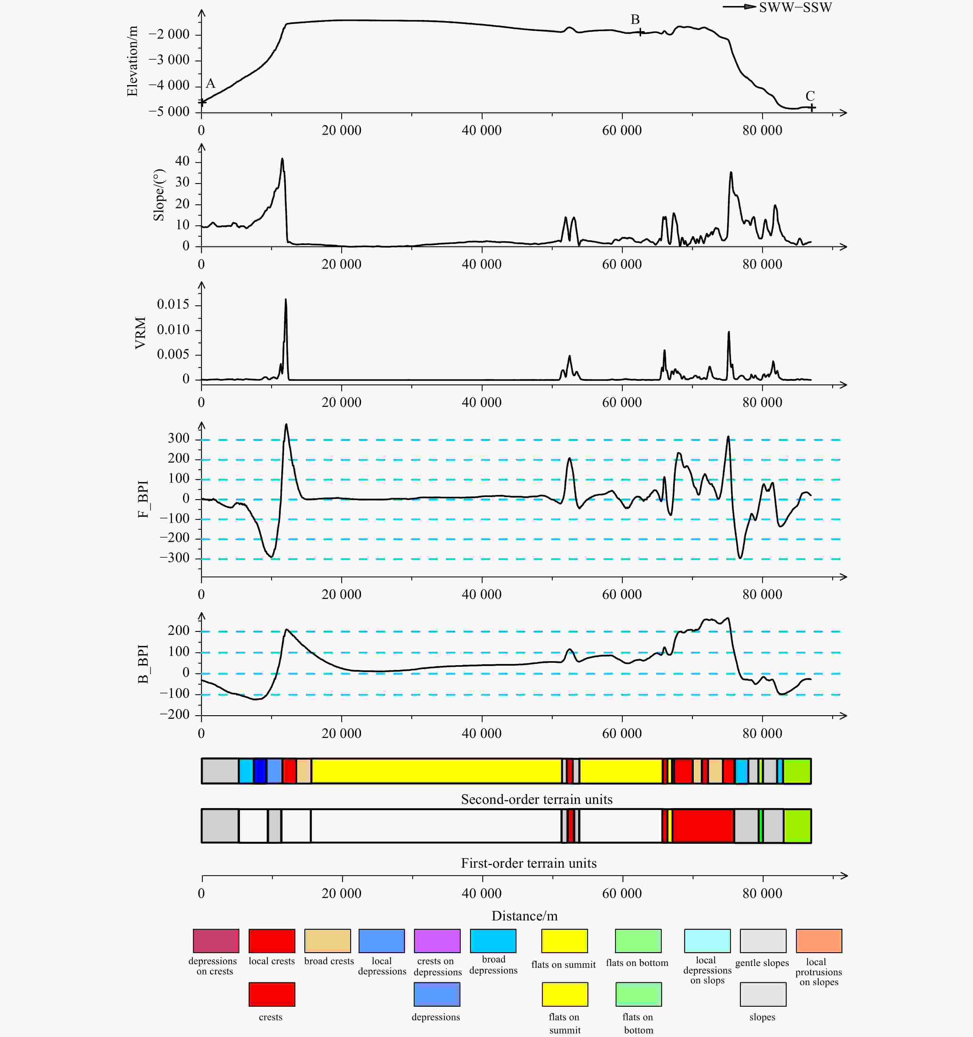
Figure 5. Synthesis profile of guyots terrain. VRM: vector ruggedness measure; B_BPI: broad-scale bathymetric position index; F_BPI: fine-scale bathymetric position index.
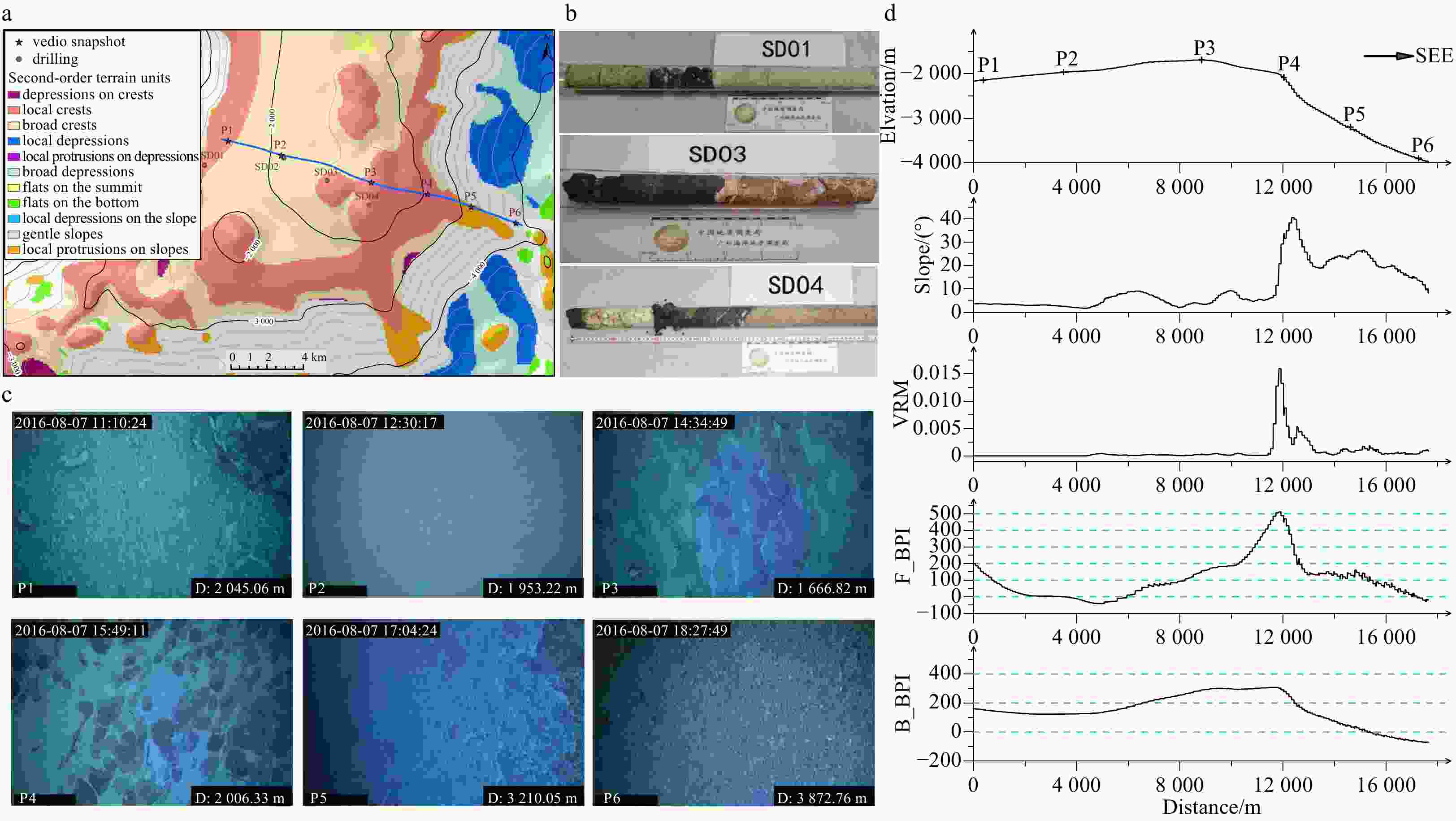
Figure 6. Geological analysis of different terrain units on the guyots. a. Second-order units; b. drilling samples; c. snapshots of vedio obtained by ROV; d. synthesis profile of terrain factors. VRM: vector ruggedness measure; B_BPI: broad-scale bathymetric position index; F_BPI: fine-scale bathymetric position index.
Table 1. Terrain factors
Terrain factors Formulation Description Reference Slope $S = \arctan \sqrt { { {\left(\dfrac{ { {{\rm{d}} }z} }{ { { {{\rm{d}}} }x} }\right)}^2} + { {\left(\dfrac{ { { {{\rm{d}}} }z} }{ { { {{\rm{d}}} }y} }\right)}^2} }$ − Horn (1981) Aspect $A = 57.295\;78 \times \arctan 2\left(\dfrac{ { { {{\rm{d}}} }z} }{ { { {{\rm{d}}} }y} } + \dfrac{ { { {{\rm{d}}} }z} }{ { { {{\rm{d}}} }x} }\right)$
${A_{\rm{N}}} = \cos A,{A_{\rm{E}}} = \sin A$AN-North, AE-East. Zevenbergen and Thorne (1987) SAPA ${ {{\rm{SAPA}}} } = \dfrac{ { { {{\rm{Are}}{{\rm{a}}_{{\rm{surface}}} } } } } }{ { { {{\rm{Are}}{{\rm{a}}_{{\rm{planer}}} } } } } }$ Areasurface: terrain surface area; Areaplaner: terrain project-planer area Jenness (2004) VRM ${ {{\rm{VRM}}} } = 1 - \dfrac{ { { {{\rm{Abs}}} }({{r}})} }{{{n}}}$, ${ {{\rm{Abs}}} }(r) = \sqrt { { {\left( {\displaystyle\sum x } \right)}^2} + { {\left( {\displaystyle\sum y } \right)}^2} + { {\left( {\displaystyle\sum z } \right)}^2} }$
$xy = 1 \times \sin \alpha $, $ z = 1 \times \cos \alpha $, $ x = xy \times \sin \beta $, $ y = xy \times \cos \beta $
Sappington et al. (2007) BPI ${ { {\rm{BPI} }({\rm{Scale factor} })} } = { { { {\rm{int} } } } } { {({\rm{Depth} } - {\rm{Dept} }{ {\rm{h} }_{ {\rm{Focal\,mean} } } }({\rm{Circle} },{\rm{Rad} }) + 0.5) } }$
${\rm{BPI} }({\rm{Scale factor} }) = { {\rm{int} } } ({\rm{Depth} } - {\rm{Dept} }{ {\rm{h} }_{ {\rm{Focal\,mean} } } }({\rm{Annulus} },{\rm{IRad} },{\rm{ORad} }) + 0.5)$− Lundblad et al. (2006) Note: − represents no description; r represents the resultant vector; Annulus, Circle: the elevation differences between a focal point and the mean elevation of the surrounding cells within a user defined annulus, or circle; Rad: Radius; IRad: inner radius of annulus in cells; ORad: outer radius of annulus in cells.  下载: 导出CSV
Table 2. Parameters of seamount terrain classification
First-order terrain units ID First-order units B_BPI_bottom B_BPI_top F_BPI_bottom F_BPI_top Slope_bottom Slope_top Depth_bottom Depth_top 1 crest 100 − − − − − − − 2 depression − −100 − − − − − − 3 flat on summit −100 100 − − − 5 −2 000 − 4 flat on slope −100 100 − − − 5 − −2 000 5 slope −100 100 − − 5 − − − Second-order terrain units ID Second-order units B_BPI_bottom B_BPI_top F_BPI_bottom F_BPI_top Slope_bottom Slope_top Depth_bottom Depth_top 11 local depressions on crests 100 −100 12 local crests 100 − 100 − − − − − 13 broad crests 100 − −100 100 − − − − 21 local depressions − −100 − −100 − − − − 22 local protrusions
on depressions− −100 100 − − − − − 23 broad depressions − −100 −100 100 − − − − 31 flats on summit −100 100 − − − 5 −2 000 − 41 flats on bottom −100 100 − − − 5 − −2 000 51 local depressions on slope −100 100 − −100 5 − − − 52 gentle slopes −100 100 −100 100 5 − − − 53 local protrusions on slopes −100 100 100 − 5 − − − Note: − represents no data.
下载: 导出CSV
-
[1] Anderson J T, Van Holliday D, Kloser R, et al. 2008. Acoustic seabed classification: current practice and future directions. ICES Journal of Marine Science, 65(6): 1004–1011. doi: 10.1093/icesjms/fsn061 [2] Asavin A M, Kubrakova I V, Mel’nikov M E, et al. 2010. Geochemical zoning in ferromanganese crusts of Ita-MaiTai Guyot. Geochemistry International, 48(5): 423–445. doi: 10.1134/S0016702910050010 [3] Bishop M P, James L A, Shroder J F Jr, et al. 2012. Geospatial technologies and digital geomorphological mapping: Concepts, issues and research. Geomorphology, 137(1): 5–26. doi: 10.1016/j.geomorph.2011.06.027 [4] Calder B R, Mayer L A. 2003. Automatic processing of high-rate, high-density multibeam echosounder data. Geochemistry, Geophysics, Geosystems, 4(6): 1048, [5] Casalbore D. 2017. Volcanic Islands and Seamounts. In: Micallef A, Krastel S, Savini A, eds. Submarine Geomorphology. Cham: Springer, 333–347 [6] Czarnecki M F, Bergin J M. 1986. Characteristics of the two-dimensional spectrum of roughness on a seamount. Washington, DC: Naval Research Laboratory, 483–488 [7] Du Preez C. 2015. A new arc-chord ratio (ACR) rugosity index for quantifying three-dimensional landscape structural complexity. Landscape Ecology, 30(1): 181–192, [8] Galparsoro I, Connor D W, Borja Á, et al. 2012. Using EUNIS Habitat classification for benthic mapping in European seas: Present concerns and future needs. Marine Pollution Bulletin, 64(12): 2630–2638. doi: 10.1016/j.marpolbul.2012.10.010 [9] Harris P T, Macmillan-Lawler M, Rupp J, et al. 2014. Geomorphology of the oceans. Marine Geology, 352: 4–24. doi: 10.1016/j.margeo.2014.01.011 [10] Hein J R, Koschinsk A, Bau M, et al. 2000. Chapter9-Cobalt-rich ferromanganese crusts in the Pacific. In: Cronan D S, ed. Handbook of Marine Mineral Deposits. New York: CRC Press, 239–279 [11] Hein J R, Koschinsky A. 2013. Deep-ocean ferromanganese crusts and nodules. In: Heinrich D, Karl K T, eds. Treatise on Geochemistry. 2nd ed. Amsterdam: Elsevier, 273–291 [12] Horn B K P. 1981. Hill shading and the reflectance map. Proceedings of the IEEE, 69(1): 14–47. doi: 10.1109/PROC.1981.11918 [13] Jasiewicz J, Stepinski T F. 2013. Geomorphons—a pattern recognition approach to classification and mapping of landforms. Geomorphology, 182: 147–156. doi: 10.1016/j.geomorph.2012.11.005 [14] Jenness J S. 2004. Calculating landscape surface area from digital elevation models. Wildlife Society bulletin, 32(3): 829–839. doi: 10.2193/0091-7648(2004)032[0829:CLSAFD]2.0.CO;2 [15] Kågesten G, Fiorentino D, Baumgartner F, et al. 2019. How do continuous high-resolution models of patchy seabed habitats enhance classification schemes?. Geosciences, 9(5): 237, [16] Kim S S, Wessel P. 2011. New global seamount census from altimetry-derived gravity data. Geophysical Journal International, 186(2): 615–631. doi: 10.1111/j.1365-246X.2011.05076.x [17] Lecours V, Dolan M F J, Micallef A, et al. 2016. A review of marine geomorphometry, the quantitative study of the seafloor. Hydrology and Earth System Sciences, 20(8): 3207–3244. doi: 10.5194/hess-20-3207-2016 [18] Ligas M, Banasik P. 2011. Conversion between Cartesian and geodetic coordinates on a rotational ellipsoid by solving a system of nonlinear equations. Geodesy and Cartography, 60(2): 145–159. doi: 10.2478/v10277-012-0013-x [19] Lundblad E R, Wright D J, Miller J, et al. 2006. A benthic terrain classification scheme for American Samoa. Marine Geodesy, 29(2): 89–111. doi: 10.1080/01490410600738021 [20] Masson D G, Watts A B, Gee M J R, et al. 2002. Slope failures on the flanks of the western Canary Islands. Earth-Science Reviews, 57(1–2): 1–35. doi: 10.1016/S0012-8252(01)00069-1 [21] Mitchell N C. 2001. Transition from circular to stellate forms of submarine volcanoes. Journal of Geophysical Research: Solid Earth, 106(B2): 1987–2003. doi: 10.1029/2000JB900263 [22] Na Jieying, Chen Wanying, Zhang Dongsheng, et al. 2021. Morphological description and population structure of an ophiuroid species from cobalt-rich crust seamounts in the Northwest Pacific: implications for marine protection under deep-sea mining. Acta Oceanologica Sinica, 40(12): 79–89. doi: 10.1007/s13131-020-1666-1 [23] Palomino D, Vázquez J T, Somoza L, et al. 2016. Geomorphological features in the southern Canary Island Volcanic Province: The importance of volcanic processes and massive slope instabilities associated with seamounts. Geomorphology, 255: 125–139. doi: 10.1016/j.geomorph.2015.12.016 [24] Petersen S, Krätschell A, Augustin N, et al. 2016. News from the seabed-Geological characteristics and resource potential of deep-sea mineral resources. Marine Policy, 70: 175–187. doi: 10.1016/j.marpol.2016.03.012 [25] Sappington J M, Longshore K M, Thompson D B. 2007. Quantifying landscape ruggedness for animal habitat analysis: a case study using Bighorn Sheep in the Mojave Desert. Journal of Wildlife Management, 71(5): 1419–1426. doi: 10.2193/2005-723 [26] Sisavath E, Babonneau N, Saint-Ange F, et al. 2011. Morphology and sedimentary architecture of a modern volcaniclastic turbidite system: the Cilaos fan, offshore La Réunion Island. Marine Geology, 288(1–4): 1–17. doi: 10.1016/j.margeo.2011.06.011 [27] Staudigel H, Koppers A A P. 2015. Chapter 22-Seamounts and island building. In: Sigurdsson H, ed. The Encyclopedia of Volcanoes. 2nd ed. Amsterdam: Elsevier, 405–421 [28] Strong J A, Clements A, Lillis H, et al. 2019. A review of the influence of marine habitat classification schemes on mapping studies: Inherent assumptions, influence on end products, and suggestions for future developments. ICES Journal of Marine Science, 76(1): 10–22. doi: 10.1093/icesjms/fsy161 [29] Tang Guoan. 2014. Progress of DEM and digital terrain analysis in China. Acta Geographica Sinica, 69(9): 1305–1325 [30] Tang Guoan, Na Jiaming, Cheng Weiming. 2017. Progress of digital terrain analysis on regional geomorphology in China. Acta Geodaetica et Cartographica Sinica, 46(10): 1570–1591 [31] Tozer B, Sandwell D T, Smith W H F, et al. 2019. Global bathymetry and topography at 15 Arc Sec: SRTM15+. Earth and Space Science, 6(10): 1847–1864. doi: 10.1029/2019EA000658 [32] Utkin V P. 2006. Role of strike-slip faulting of the oceanic lithosphere in the formation of Pacific volcanic belts. Doklady Earth Sciences, 409(1): 692–696. doi: 10.1134/S1028334X06050023 [33] Walbridge S, Slocum N, Pobuda M, et al. 2018. Unified geomorphological analysis workflows with Benthic Terrain modeler. Geosciences, 8(3): 94. doi: 10.3390/geosciences8030094 [34] Watt S F L, Talling P J, Vardy M E, et al. 2012. Widespread and progressive seafloor-sediment failure following volcanic debris avalanche emplacement: Landslide dynamics and timing offshore Montserrat, Lesser Antilles. Marine Geology, 323–325: 69–94, [35] Weiss A D. 2001. Topographic position and landforms analysis. San Diego, CA: ESRI User Conference [36] Wright D, Pendleton M, Boulware J, et al. 2018. ArcGIS Benthic Terrain Modeler (BTM), v. 3.0. https://esriurl.com/5754[2018-02-27] [37] Xu Jian, Zheng Yulong, Bao Gengsheng, et al. 2011. Research of seamount micro-topography based on acoustic deep-tow system investigation: A case from the Marcus-Wake Ridge area. Journal of Marine Sciences, 29(1): 17–24 [38] Yang Yong, He Gaowen, Liu Fanglan, et al. 2016a. Gravity and magnetic anomalies of Jiaxie Guyots and their structural and sedimentary characteristics. Marine Geology & Quaternary Geology, 36(1): 107–113 [39] Yang Yong, He Gaowen, Ma Jinfeng, et al. 2020. Acoustic quantitative analysis of ferromanganese nodules and cobalt-rich crusts distribution areas using EM122 multibeam backscatter data from deep-sea basin to seamount in western Pacific Ocean. Deep-Sea Research Part I: Oceanographic Research Papers, 161: 103281. doi: 10.1016/j.dsr.2020.103281 [40] Yang Yong, He Gaowen, Zhu Kechao, et al. 2016b. Classification of seafloor geological types of Qianyu seamount from mid-Pacific seamounts using multibeam backscatter intensity data. Earth Science, 41(4): 718–728 [41] Zevenbergen L W, Thorne C R. 1987. Quantitative analysis of land surface topography. Earth Surface Processes and Landforms, 12(1): 47–56. doi: 10.1002/esp.3290120107 [42] Zhang Huodai, Yao Huiqiang, Yang Yong, et al. 2018. Origin of multiple flat tables on Caiwei Guyots in West Pacific. Marine Geology & Quaternary Geology, 38(6): 91–97 [43] Zhang Weiyan, Zhang Fuyuan, Zhu Kechao, et al. 2009. Fractal research on seamount topography in the West Pacific Ocean. Geoscience, 23(6): 1138–1146 [44] Zhang Huodai, Zhu Benduo, Guan Yongxian, et al. 2017. Topographic features of the seamounts in the central basin of the South China Sea: based on multi-beam bathymetric data. Marine Geology & Quaternary Geology, 37(6): 149–157 [45] Zhao Jianhu, Ouyang Yongzhong, Wang Aixue. 2017. Status and development tendency for seafloor terrain measurement technology. Acta Geodaetica et Cartographica Sinica, 46(10): 1786–1794 [46] Zhao Bin, Yang Yong, Zhang Xiangyu, et al. 2020. Sedimentary characteristics based on sub-bottom profiling and the implications for mineralization of cobalt-rich ferromanganese crusts at Weijia Guyot, western Pacific Ocean. Deep-Sea Research Part I: Oceanographic Research Papers, 158: 103223. doi: 10.1016/j.dsr.2020.103223 -


 点击查看大图
计量
- 文章访问数: 801
- HTML全文浏览量: 266
- PDF下载量: 27
- 被引次数: 0

