2021 Vol. 40, No. 2

Cover
2021, 40(2): .
Abstract:
2021-2 Contents
2021, (2): 1-2.
Abstract:
Natural gas geology in the South China Sea
The geological characteristics of the large- and medium-sized gas fields in the South China Sea
Gongcheng Zhang, Dongdong Wang, Lei Lan, Shixiang Liu, Long Su, Long Wang, Wu Tang, Jia Guo, Rui Sun
2021, 40(2): 1-12. doi: 10.1007/s13131-021-1754-x
Abstract:
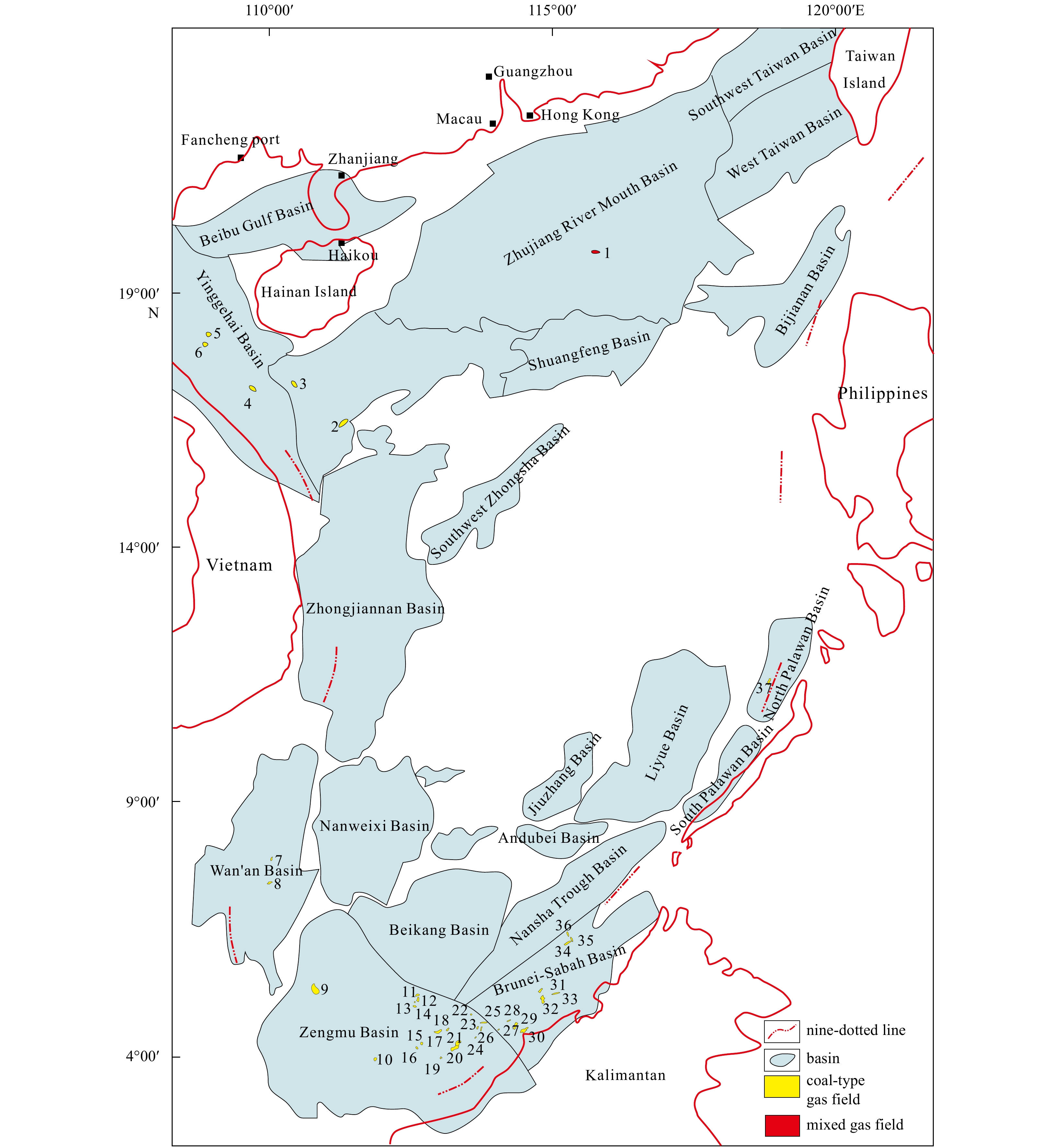
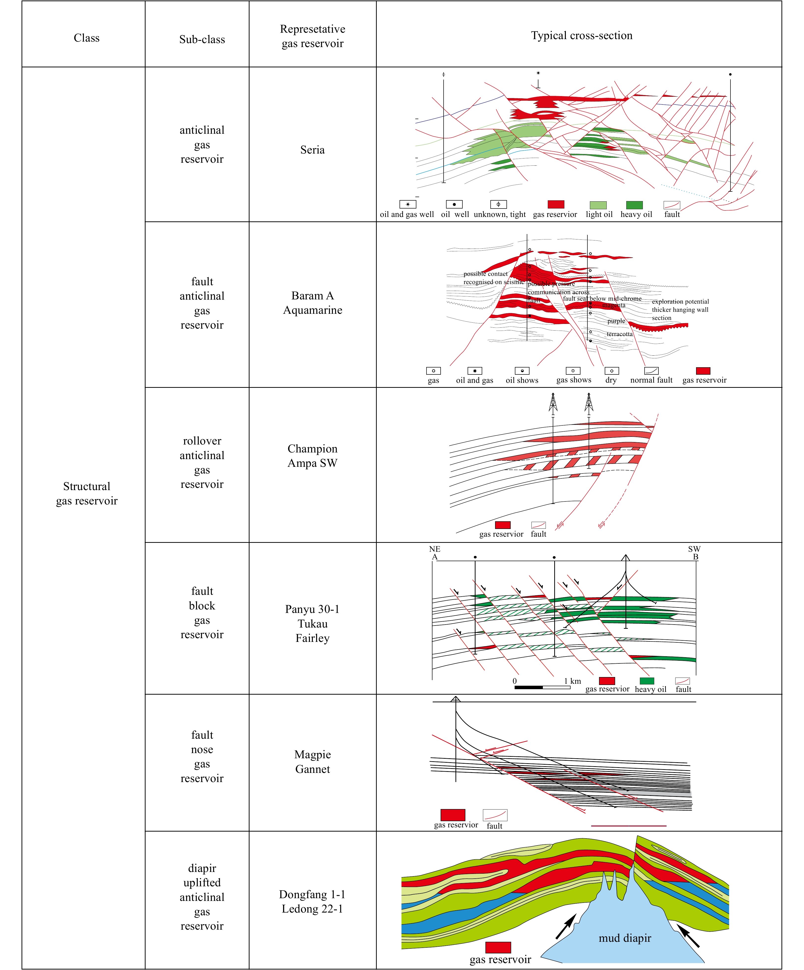
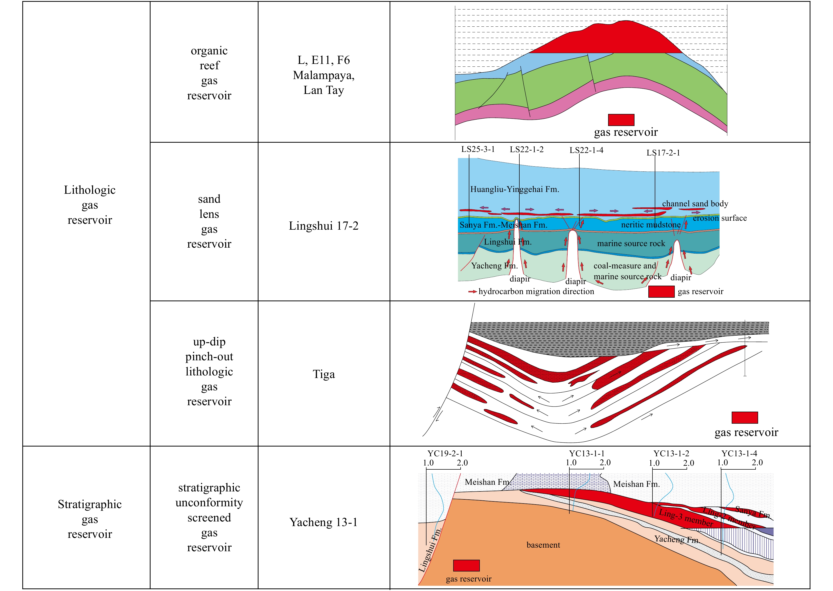
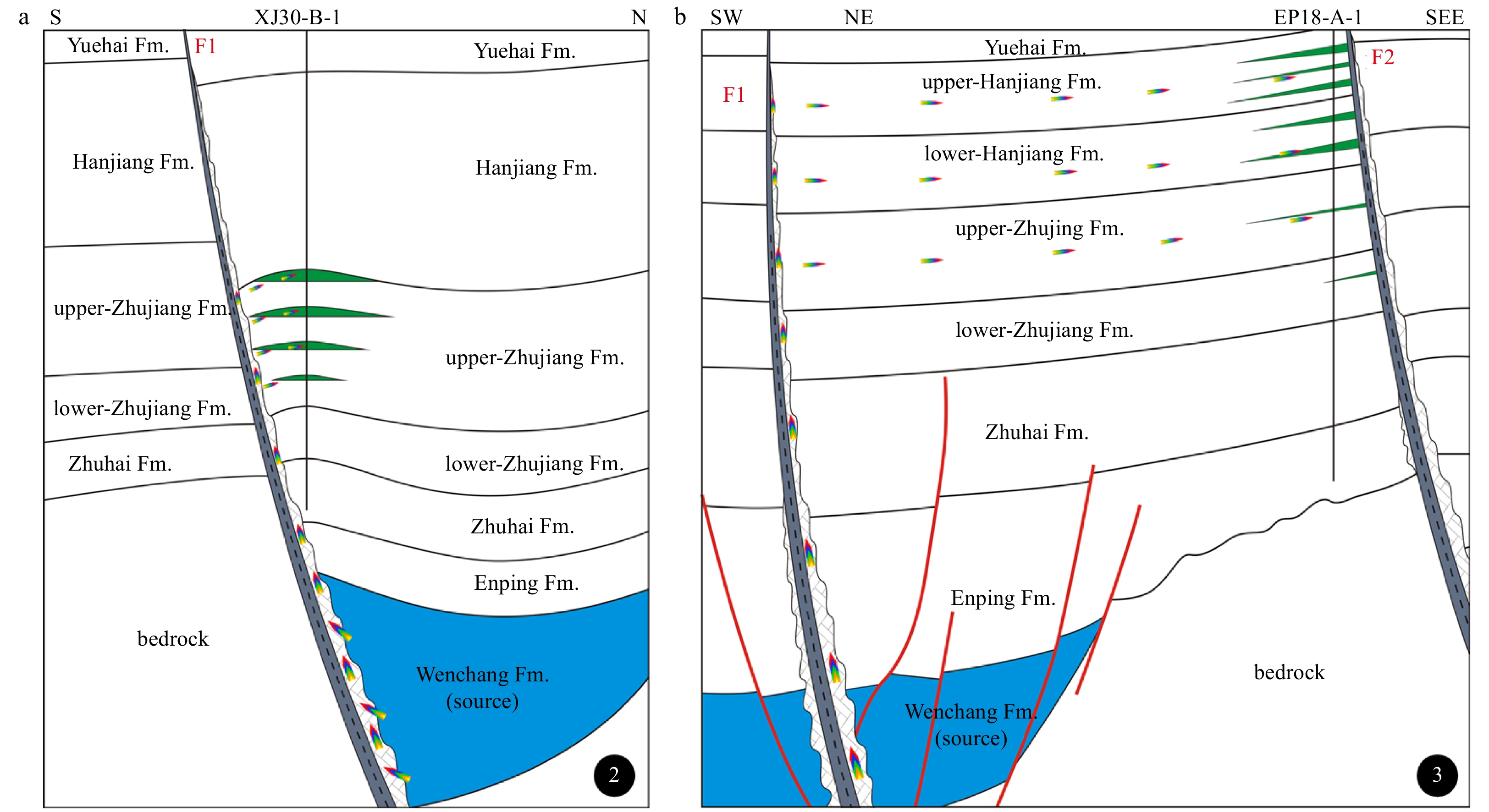
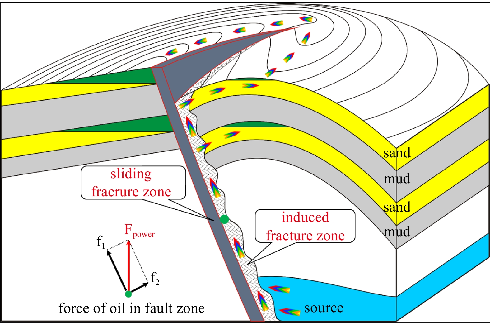
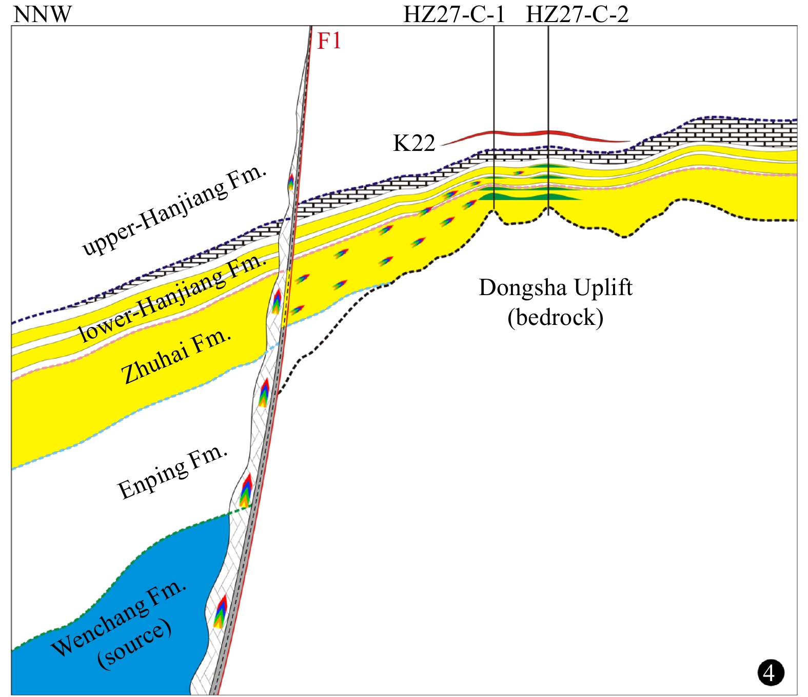
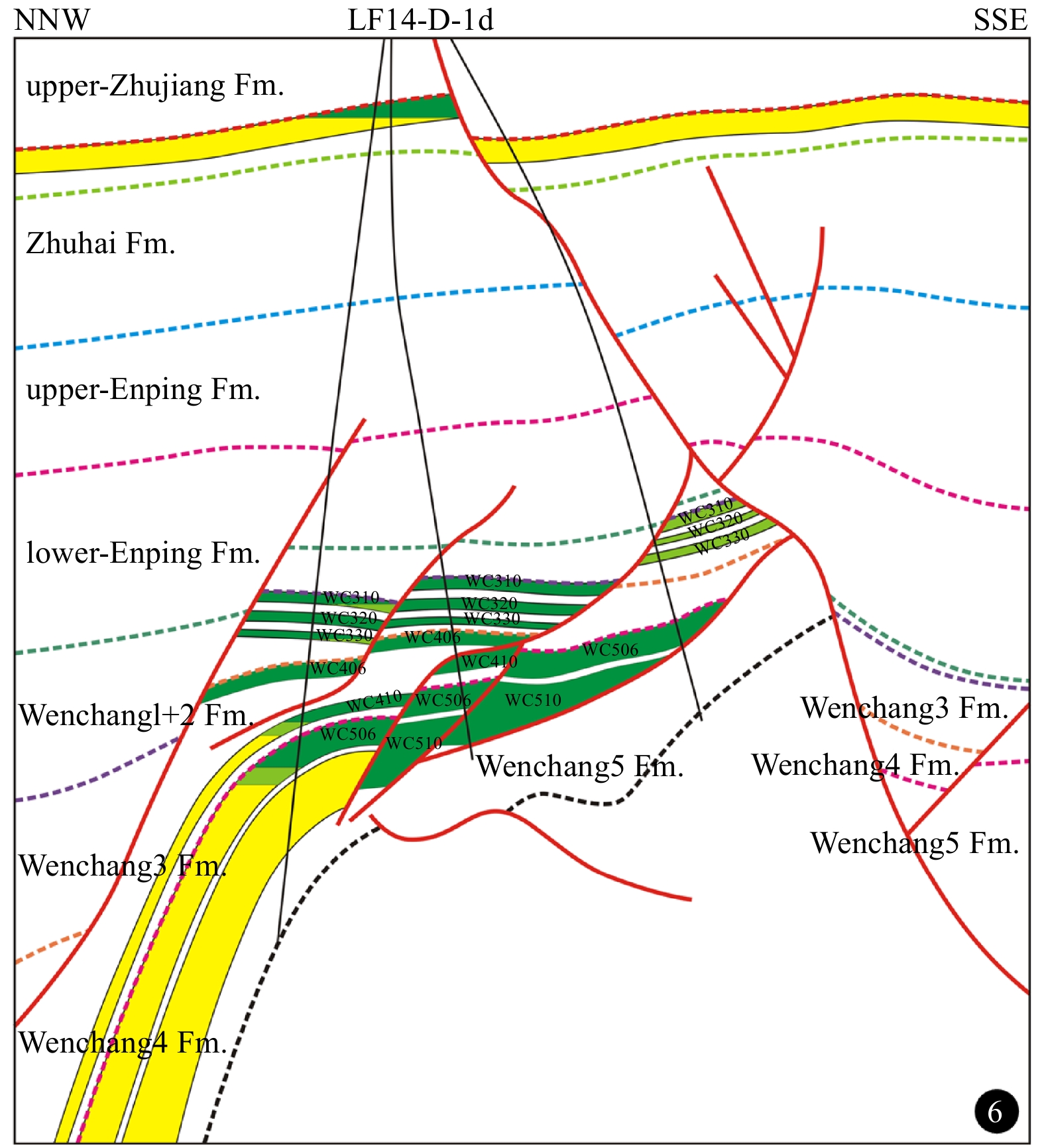
By the end of 2019, more than 220 gas fields had been discovered in the South China Sea. In order to accurately determine the geological characteristics of the large- and medium-sized gas fields in the South China Sea, this study conducted a comprehensive examination of the gas fields. Based on the abundant available geologic and geochemical data, the distribution and key controlling factors of the hydrocarbon accumulation in the South China Sea were analyzed. The geological and geochemical features of the gas fields were as follows: (1) the gas fields were distributed similar to beads in the shape of a “C” along the northern, western, and southern continental margins; (2) the natural gas in the region was determined to be composed of higher amounts of alkane gas and less CO2; (3) the majority of the alkane gas was observed to be coal-type gas; (4) the gas reservoir types included structural reservoirs, lithologic reservoirs, and stratigraphic reservoirs, respectively; (5) the reservoir ages were mainly Oligocene, Miocene, and Pliocene, while the lithology was mainly organic reef, with some sandstone deposits; and (6) the main hydrocarbon accumulation period for the region was determined to be the late Pliocene-Quaternary Period. In addition, the main controlling factors of the gas reservoirs were confirmed to have been the development of coal measures, sufficient thermal evolution, and favorable migration and accumulation conditions.
Reinterpretation of the northern South China Sea pre-Cenozoic basement and geodynamic implications of the South China continent: constraints from combined geological and geophysical records
Weilin Zhu, Yuchi Cui, Lei Shao, Peijun Qiao, Peng Yu, Jianxiang Pei, Xinyu Liu, Hao Zhang
2021, 40(2): 13-28. doi: 10.1007/s13131-021-1757-7
Abstract:
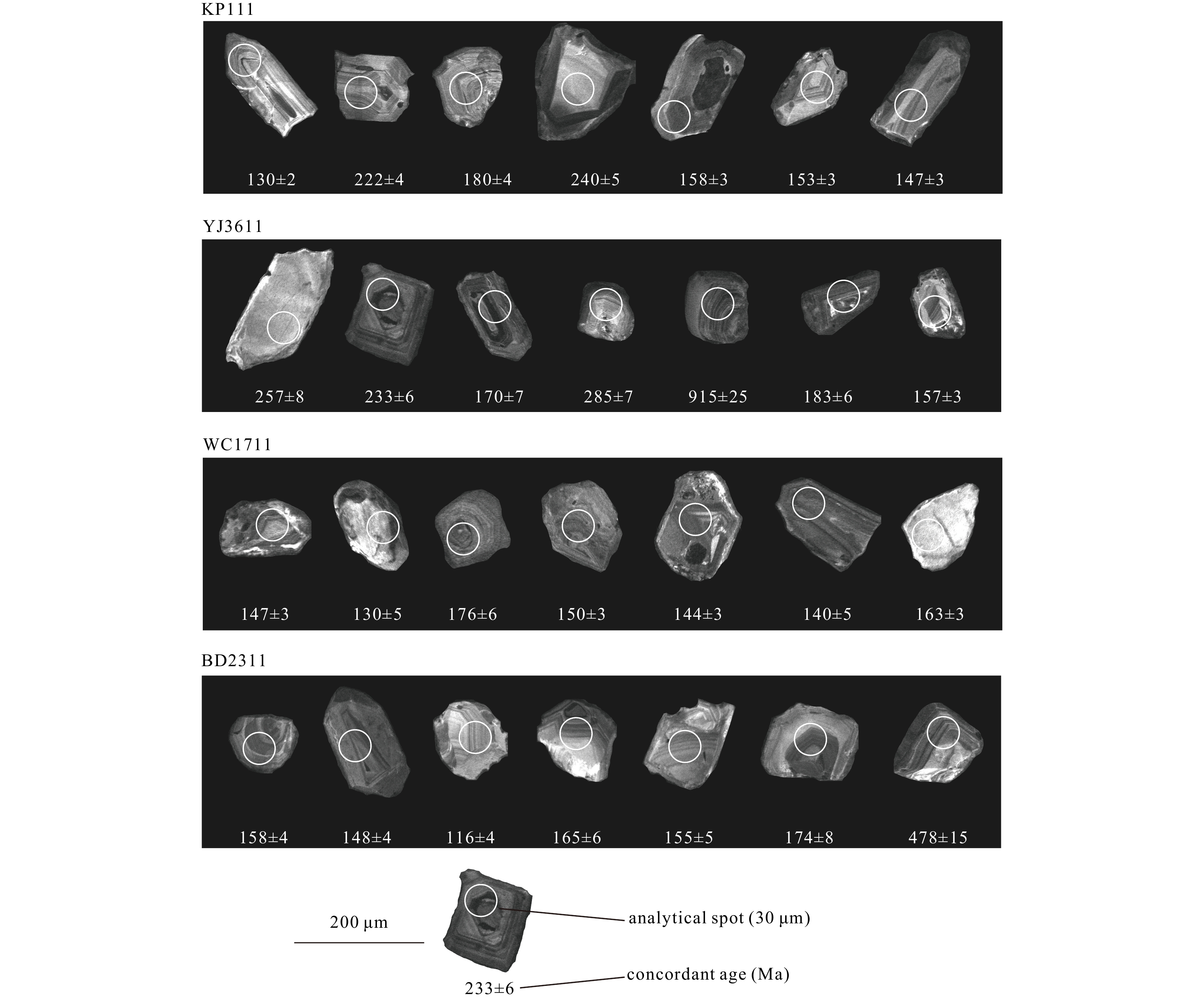
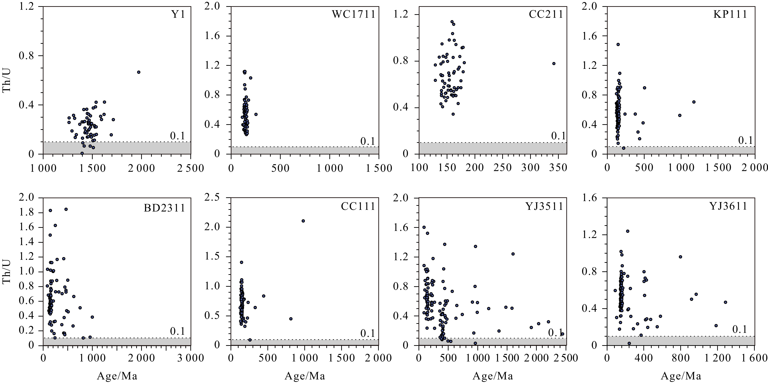
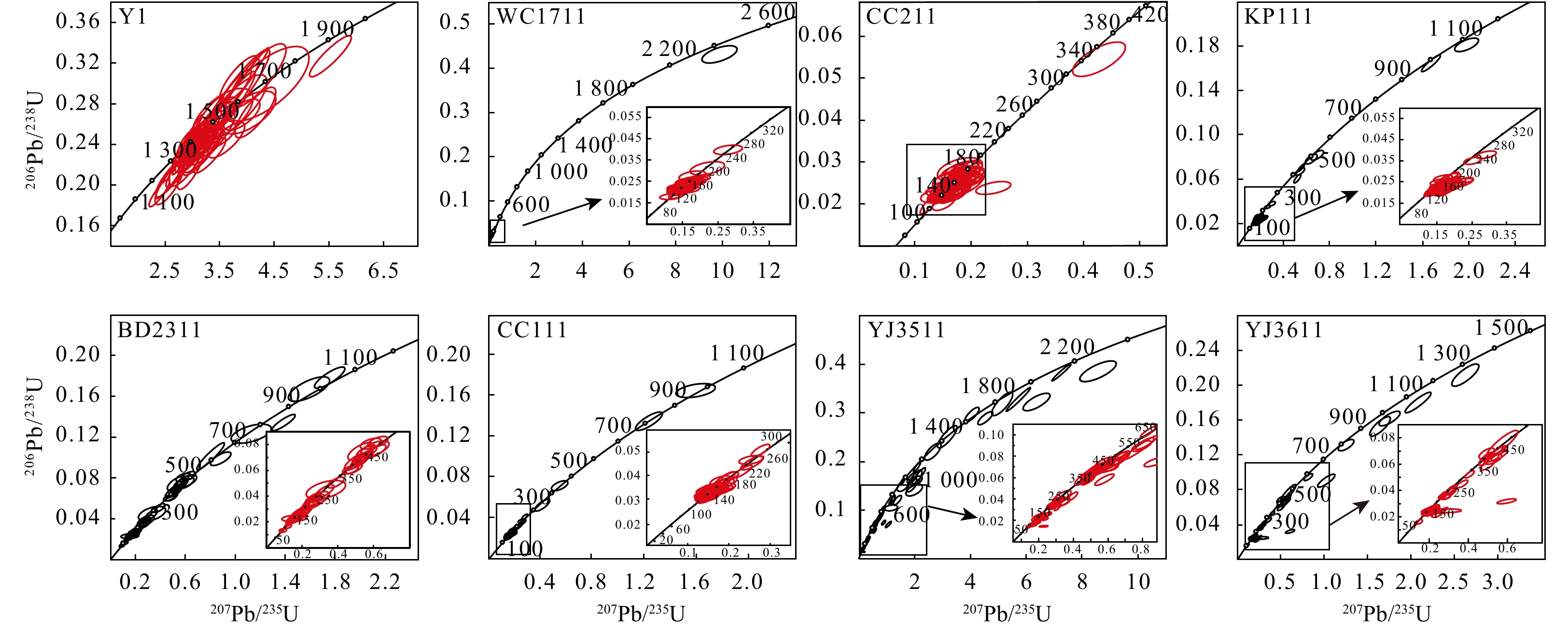
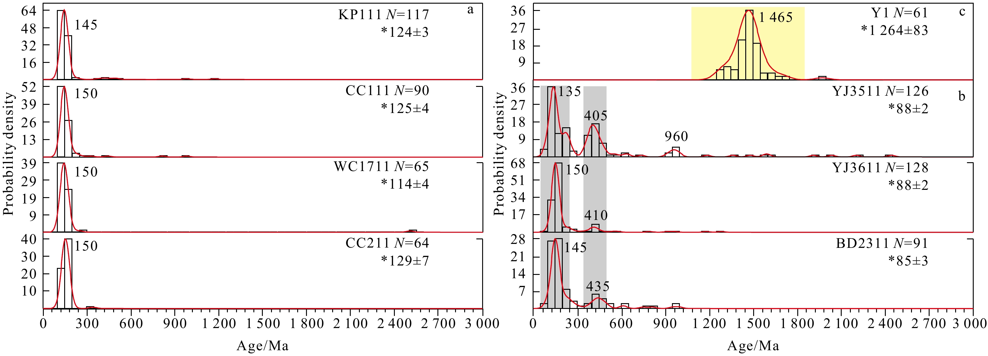
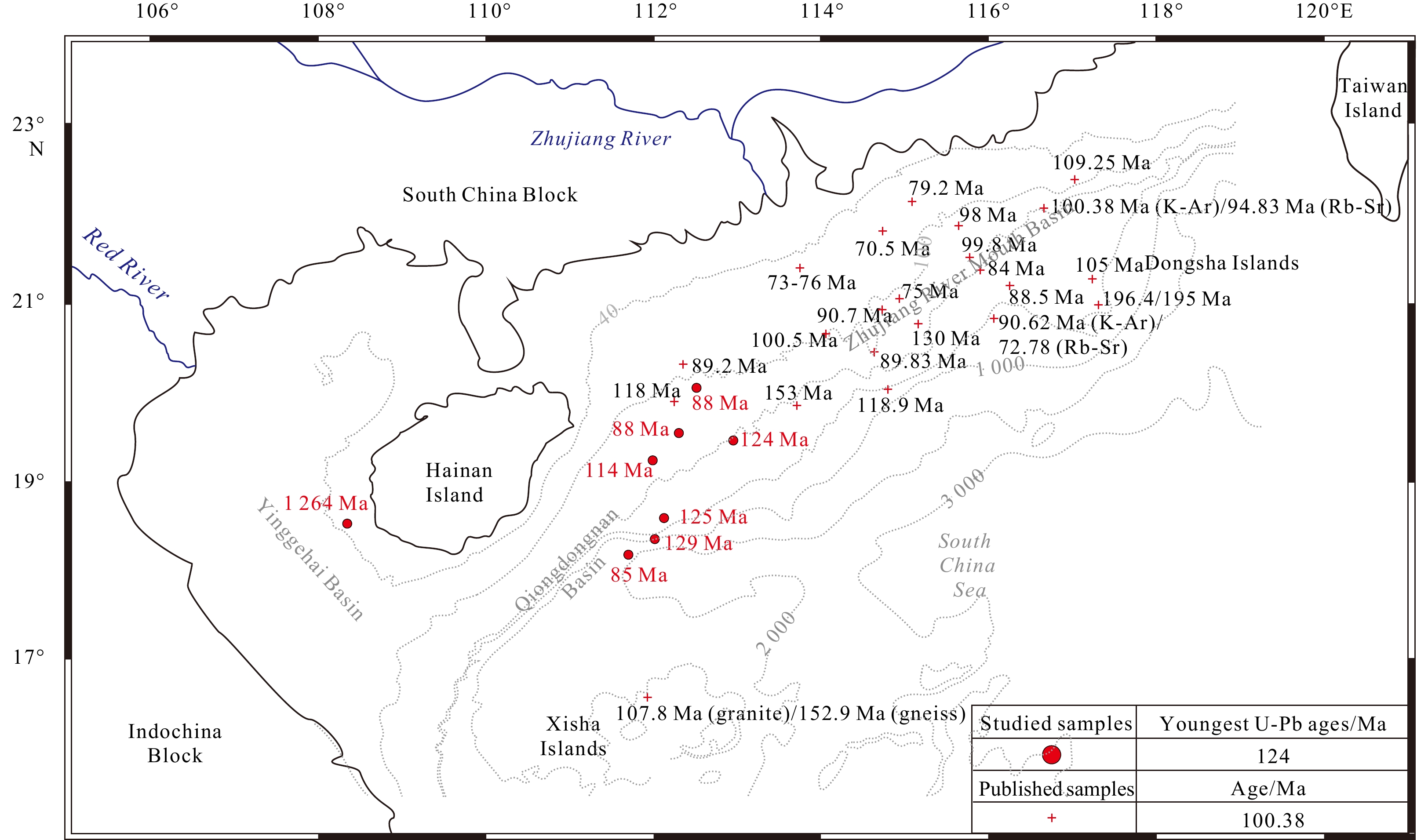
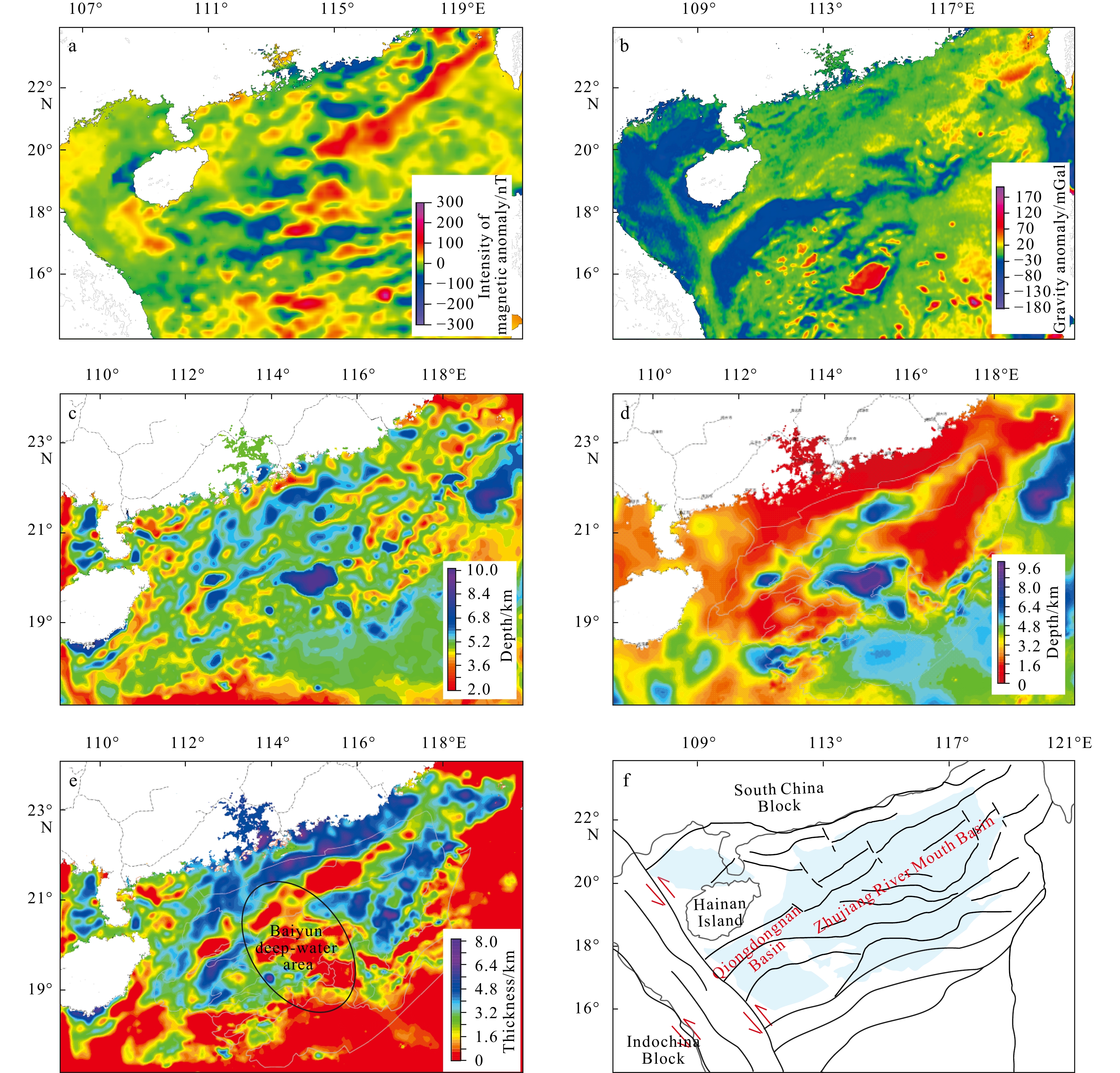
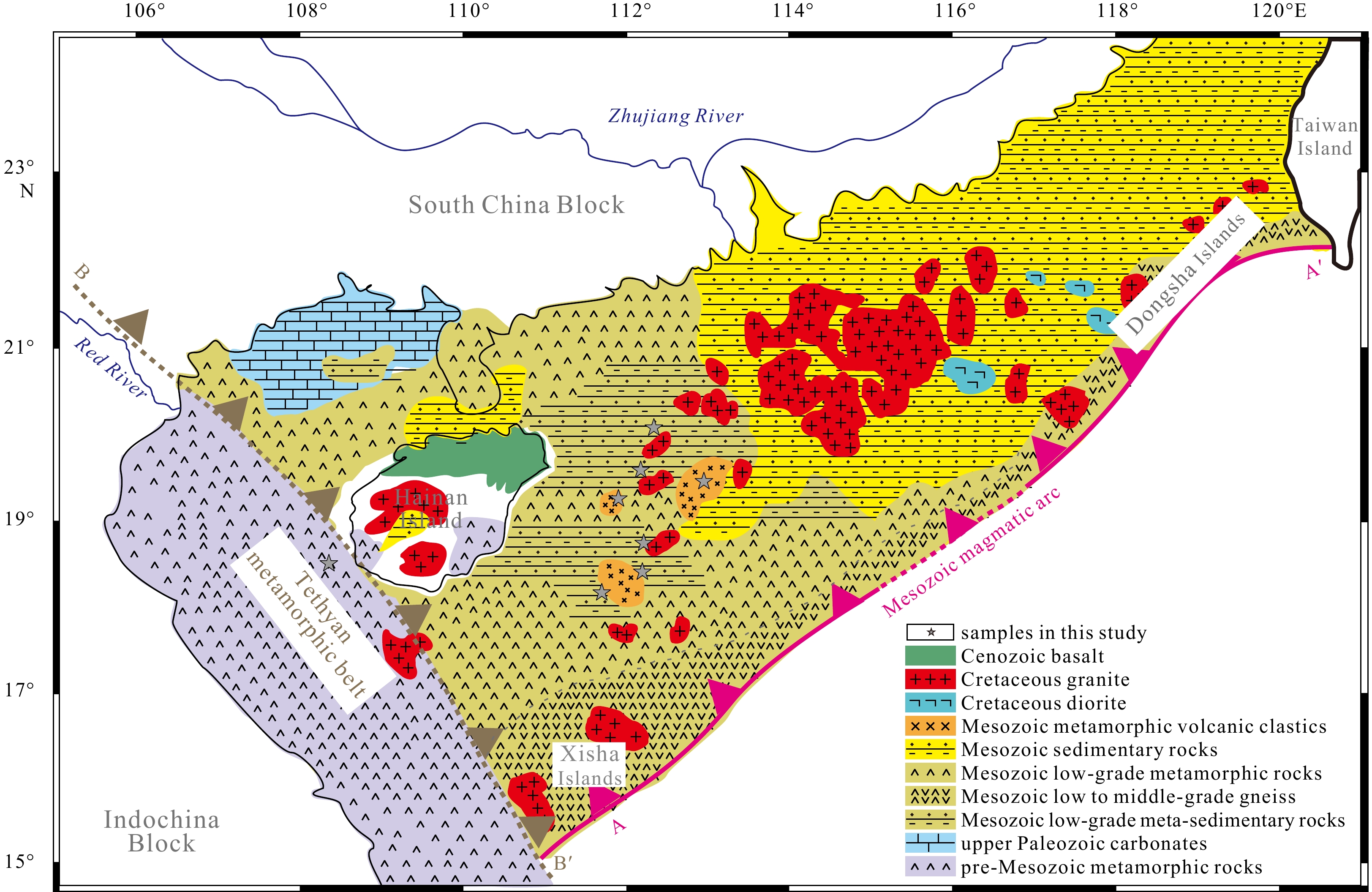
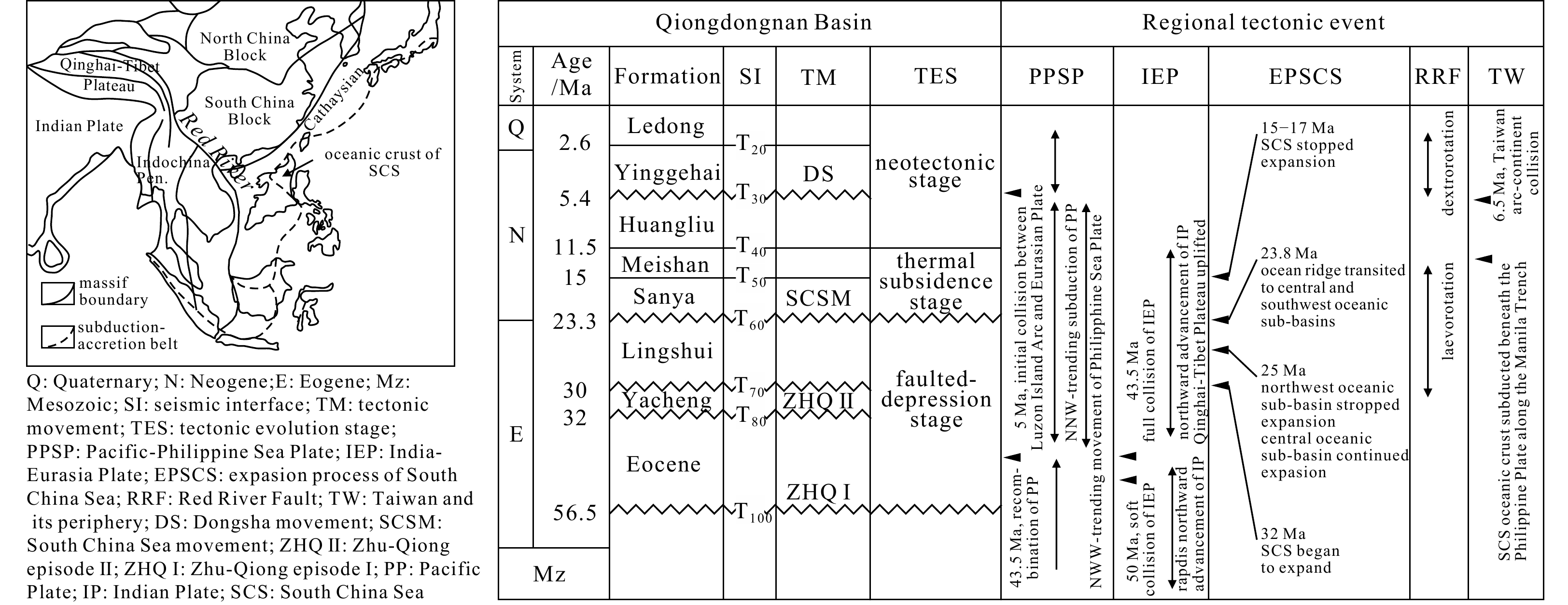
The pre-Cenozoic northern South China Sea (SCS) Basin basement was supposed to exist as a complex of heterogeneous segments, divided by dozens of N−S faulting. Unfortunately, only the Hainan Island and the northeastern SCS region were modestly dated while the extensive basement remains roughly postulated by limited geophysical data. This study presents a systematic analysis including U-Pb geochronology, elemental geochemistry and petrographic identification on granite and meta-clastic borehole samples from several key areas. Constrained from gravity-magnetic joint inversion, this interpretation will be of great significance revealing the tectono-magmatic evolution along the southeastern margin of the Eurasian Plate. Beneath the thick Cenozoic sediments, the northern SCS is composed of a uniform Mesozoic basement while the Precambrian rocks are only constricted along the Red River Fault Zone. Further eastern part of the northern SCS below the Cenozoic succession was widely intruded by granites with Jurassic-to-early Cretaceous ages. Further western part, on the other hand, is represented by meta-sedimentary rocks with relatively sporadic granite complexes. To be noted, the western areas derived higher-degree and wider metamorphic zones, which is in contrast with the lower-degree and narrower metamorphic belt developed in the eastern region. Drastic collisions between the Indochina Block and South China continent took place since at least late Triassic, resulting in large-scale suturing and deformation zones. At the westernmost part of the northern SCS, the intracontinental amalgamation with closure of the Meso-Tethys has caused fairly stronger and broader metamorphism. One metamorphic biotite granite is located on the suturing belt and yields a Precambrian U-Pb age. It likely represents the relict from the ancient Gondwana supercontinent or its fringes. Arc-continental collision between the Paleo-Pacific and the southeast China Block, on the other hand, results in a relatively narrow NE–SW trending metamorphic belt during the late Mesozoic. Within the overall geological setting, the Cenozoic SCS oceanic basin was subsequently generated from a series of rifting and faulting processes along the collisional-accretionary continental margin.
A buried submarine canyon in the northwestern South China Sea: architecture, development processes and implications for hydrocarbon exploration
Bin Wang, Fuliang Lü, Shuang Li, Jian Li, Zhili Yang, Li Li, Xuefeng Wang, Yintao Lu, Taotao Yang, Jingwu Wu, Guozhong Sun, Hongxia Ma, Xiaoyong Xu
2021, 40(2): 29-41. doi: 10.1007/s13131-021-1751-0
Abstract:
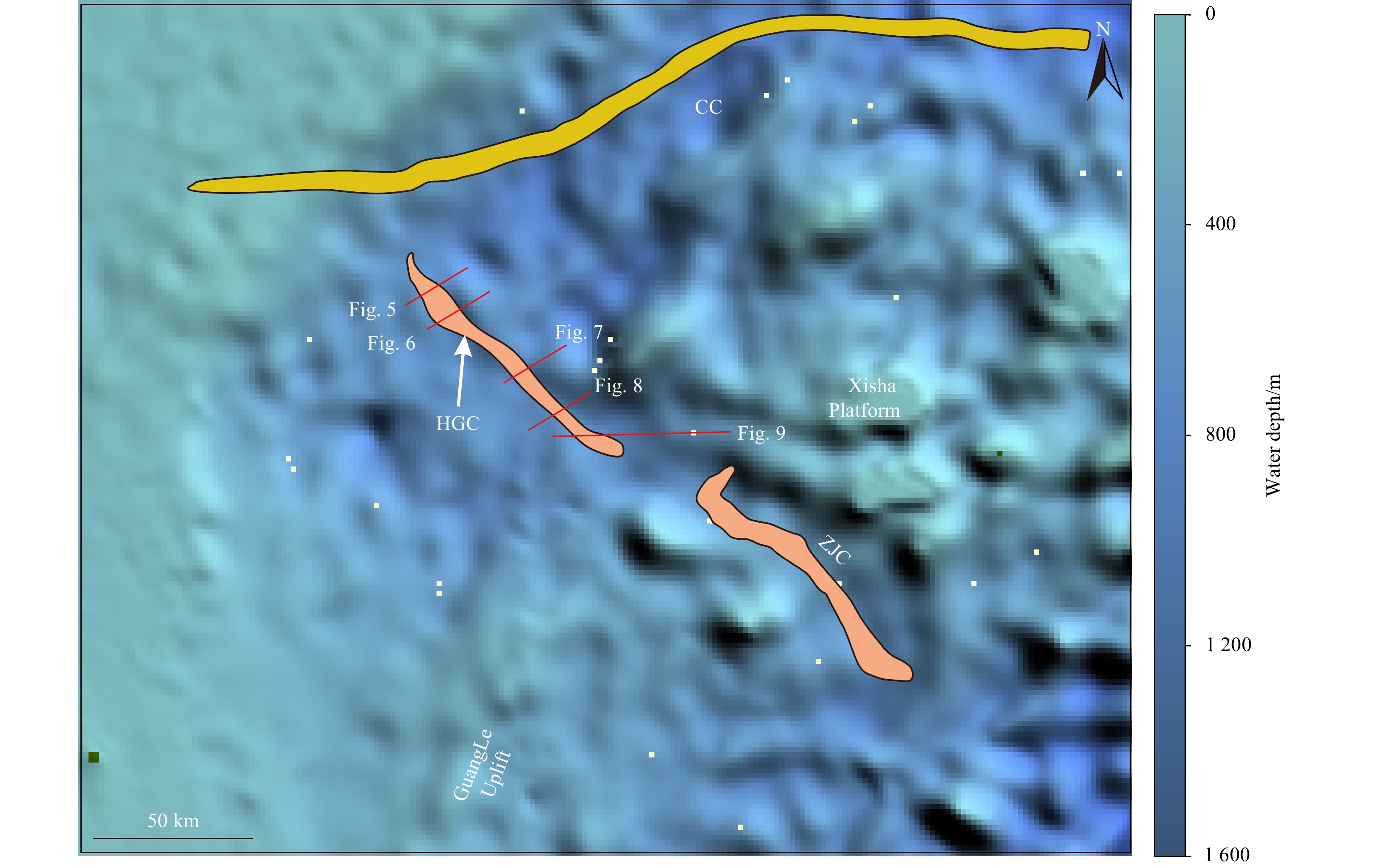
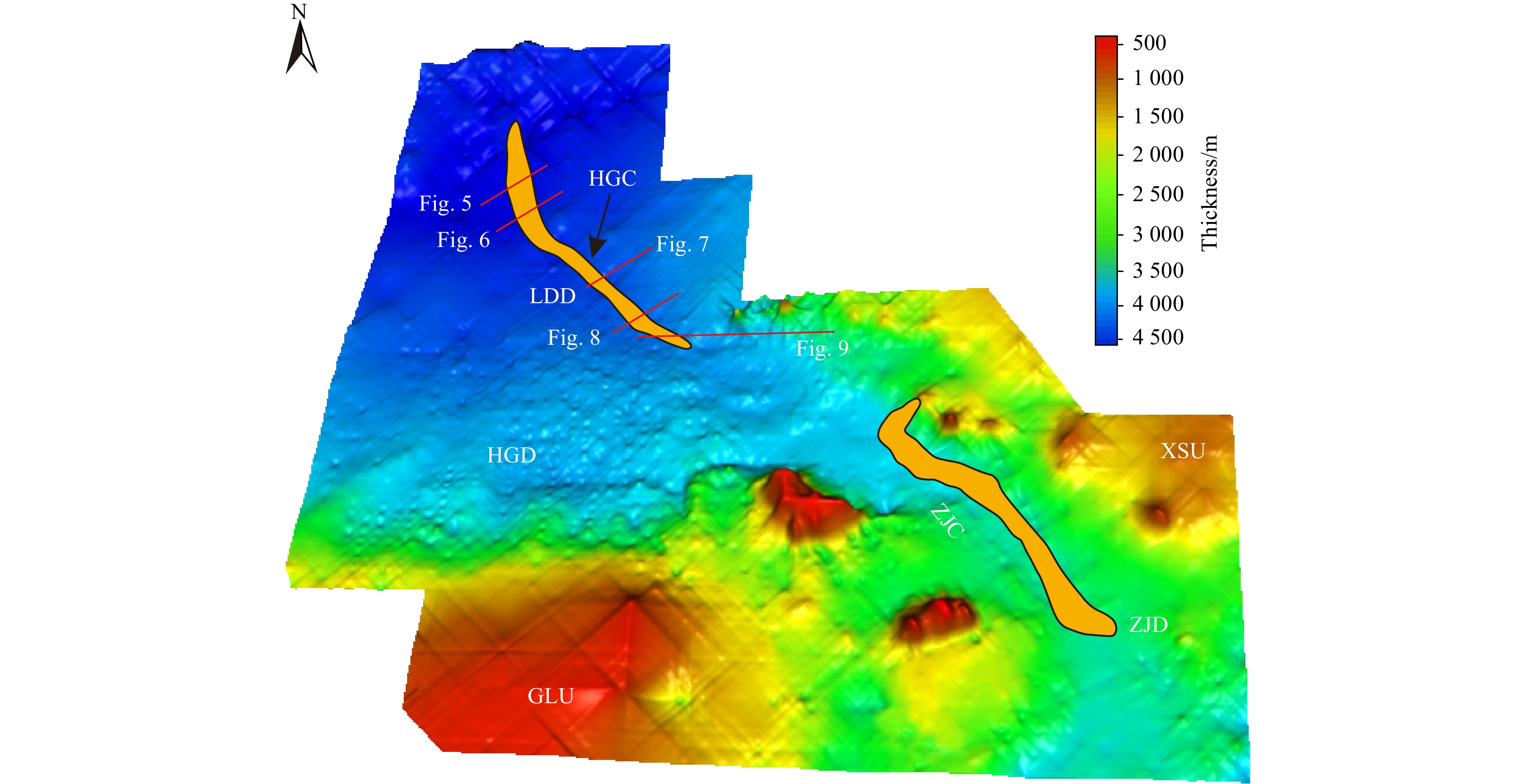
High-resolution multichannel seismic data enables the discovery of a previous, undocumented submarine canyon (Huaguang Canyon) in the Qiongdongnan Basin, northwestern South China Sea. The Huaguang Canyon with a NW orientation is 140 km in length, and 2.5 km to 5 km in width in its upper reach and 4.6 km to 9.5 km in width in its lower reach. The head of the Huaguang Canyon is close to the Xisha carbonate platform and its tail is adjacent to the Central Canyon. This buried submarine canyon is formed by gravity flows from the Xisha carbonate platform when the sea level dropped in the early stage of the late Miocene (around 10.5 Ma). The internal architecture of the Huaguang Canyon is mainly characterized by high amplitude reflections, indicating that this ancient submarine canyon was filled with coarse-grained sediments. The sediment was principally scourced from the Xisha carbonate platform. In contrast to other buried large-scale submarine canyons (Central Canyon and Zhongjian Canyon) in the Qiongdongnan Basin, the Huaguang Canyon displays later formation time, smaller width and length, and single sediment supply. The coarse-grained deposits within the Huaguang Canyon provide a good environment for reserving oil and gas, and the muddy fillings in the Huaguang Canyon have been identified as regional caps. Therefore, the Huaguang Canyon is a potential area for future hydrocarbon exploration in the northwestern South China Sea. The result of this paper may contribute to a better understanding of the evolution of submarine canyons formed in carbonate environment.
Structural characteristics of central depression belt in deep-water area of the Qiongdongnan Basin and the hydrocarbon discovery of Songnan low bulge
Mo Ji, Qingbo Zeng, Haizhang Yang, Shuai Guo, Kai Zhong
2021, 40(2): 42-53. doi: 10.1007/s13131-021-1753-y
Abstract:
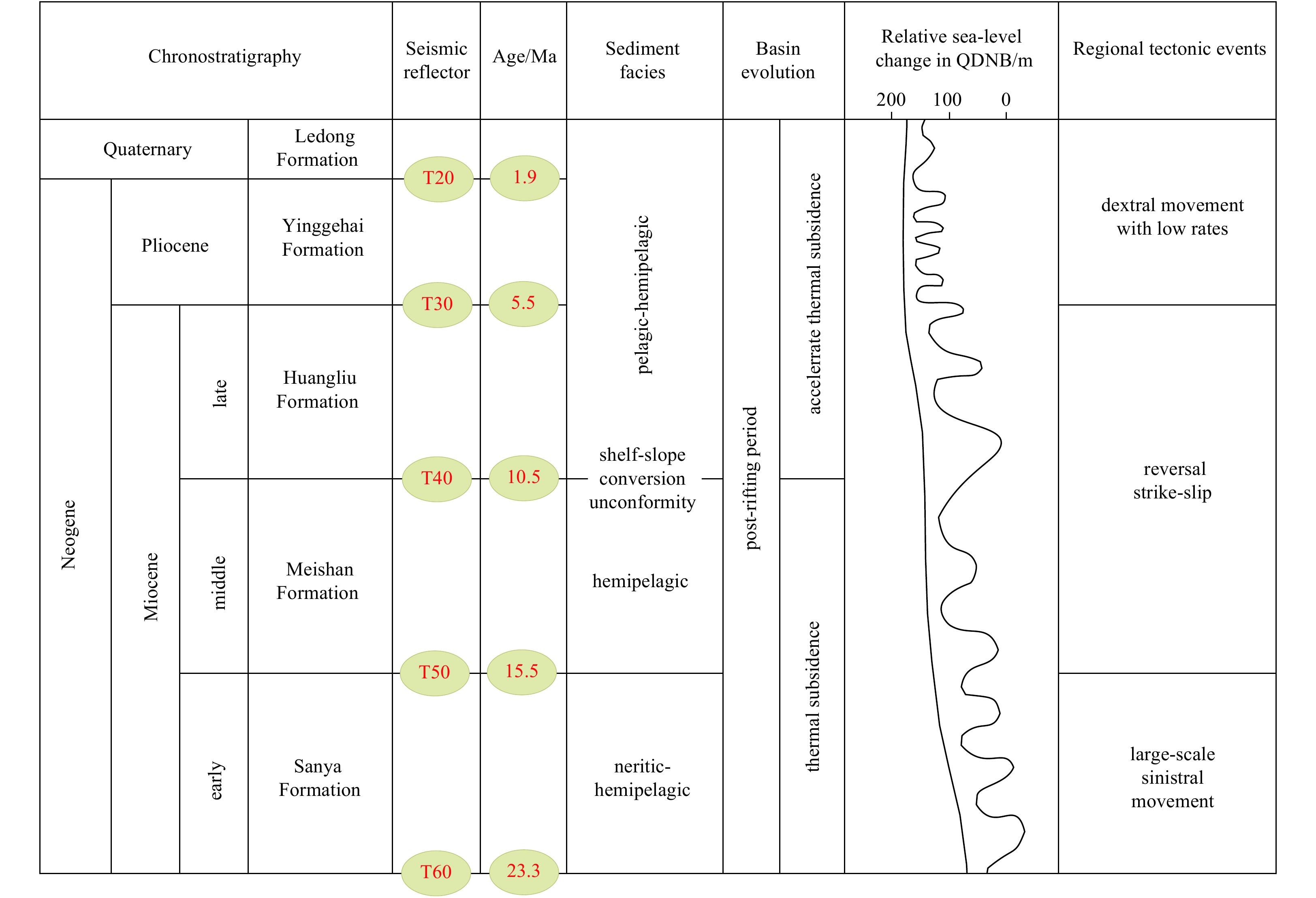
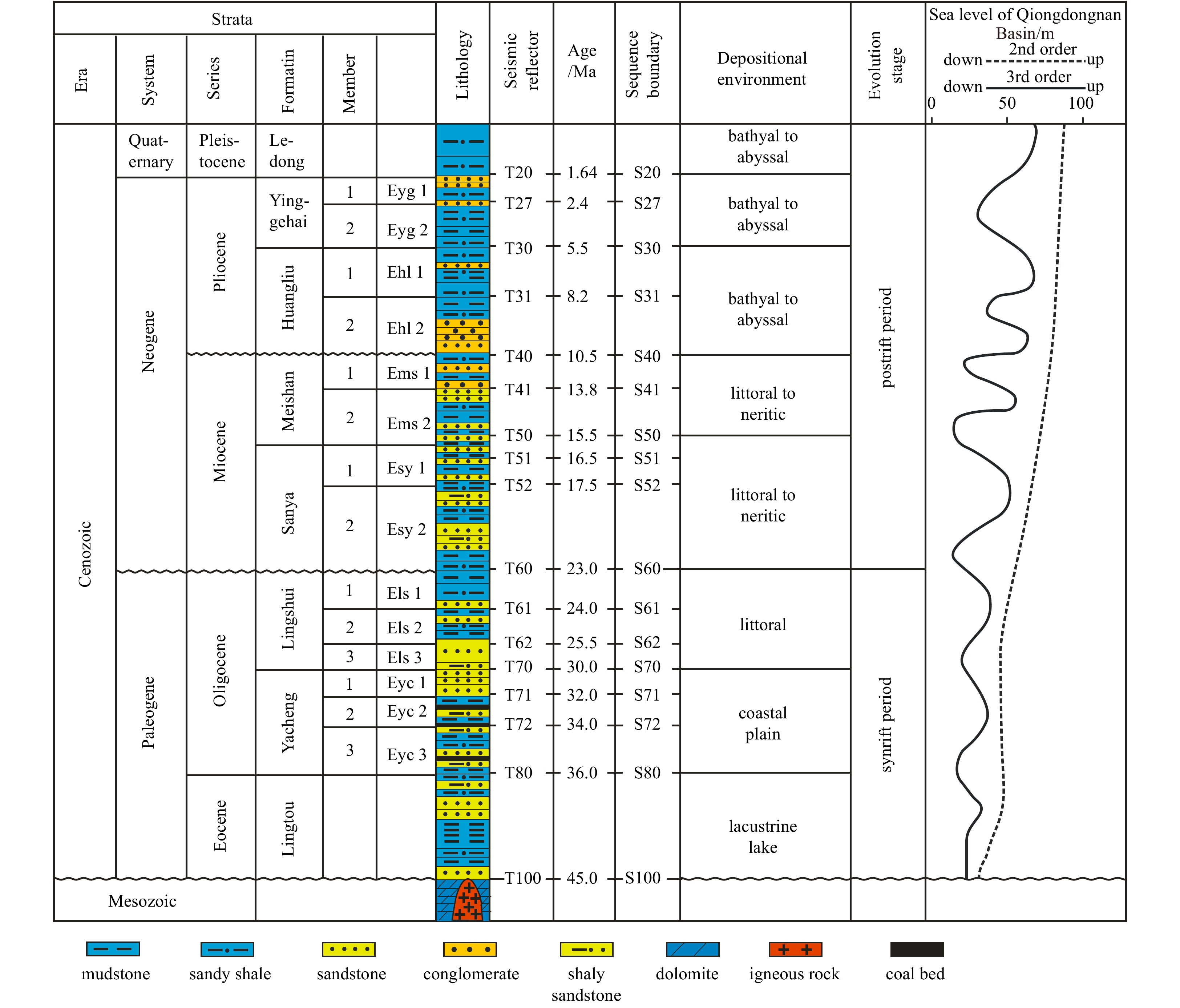
The Qiongdongnan Basin has the first proprietary high-yield gas field in deep-water areas of China and makes the significant breakthroughs in oil and gas exploration. The central depression belt of deep-water area in the Qiongdongnan Basin is constituted by five sags, i.e. Ledong Sag, Lingshui Sag, Songnan Sag, Baodao Sag and Changchang Sag. It is a Cenozoic extensional basin with the basement of pre-Paleogene as a whole. The structural research in central depression belt of deep-water area in the Qiongdongnan Basin has the important meaning in solving the basic geological problems, and improving the exploration of oil and gas of this basin. The seismic interpretation and structural analysis in this article was operated with the 3D seismic of about 1.5×10⁴ km2 and the 2D seismic of about 1×10⁴ km. Eighteen sampling points were selected to calculate the fault activity rates of the No.2 Fault. The deposition rate was calculated by the ratio of residual formation thickness to deposition time scale. The paleo-geomorphic restoration was obtained by residual thickness method and impression method. The faults in the central depression belt of deep-water area of this basin were mainly developed during Paleogene, and chiefly trend in NE–SW, E–W and NW–SE directions. The architectures of these sags change regularly from east to west: the asymmetric grabens are developed in the Ledong Sag, western Lingshui Sag, eastern Baodao Sag, and western Changchang Sag; half-grabens are developed in the Songnan Sag, eastern Lingshui Sag, and eastern Changchang Sag. The tectonic evolution history in deep-water area of this basin can be divided into three stages, i.e. faulted-depression stage, thermal subsidence stage, and neotectonic stage. The Ledong-Lingshui sags, near the Red River Fault, developed large-scale sedimentary and subsidence by the uplift of Qinghai-Tibet Plateau during neotectonic stage. The Baodao-Changchang sags, near the northwest oceanic sub-basin, developed the large-scale magmatic activities and the transition of stress direction by the expansion of the South China Sea. The east sag belt and west sag belt of the deep-water area in the Qiongdongnan Basin, separated by the ancient Songnan bulge, present prominent differences in deposition filling, diaper genesis, and sag connectivity. The west sag belt has the advantages in high maturity, well-developed fluid diapirs and channel sand bodies, thus it has superior conditions for oil and gas migration and accumulation. The east sag belt is qualified by the abundant resources of oil and gas. The Paleogene of Songnan low bulge, located between the west sag belt and the east sag belt, is the exploration potential. The YL 8 area, located in the southwestern high part of the Songnan low bulge, is a favorable target for the future gas exploration. The Well 8-1-1 was drilled in August 2018 and obtained potential business discovery, and the Well YL8-3-1 was drilled in July 2019 and obtained the business discovery.
Control effects of the synsedimentary faults on the basin-marginal fans in the central part of the deep-water area of early Oligocene Qiongdongnan Basin, South China Sea
Guangzeng Song, Zengxue Li, Haizhang Yang, Dongdong Wang, Ying Chen, Rui Sun
2021, 40(2): 54-64. doi: 10.1007/s13131-021-1749-7
Abstract:
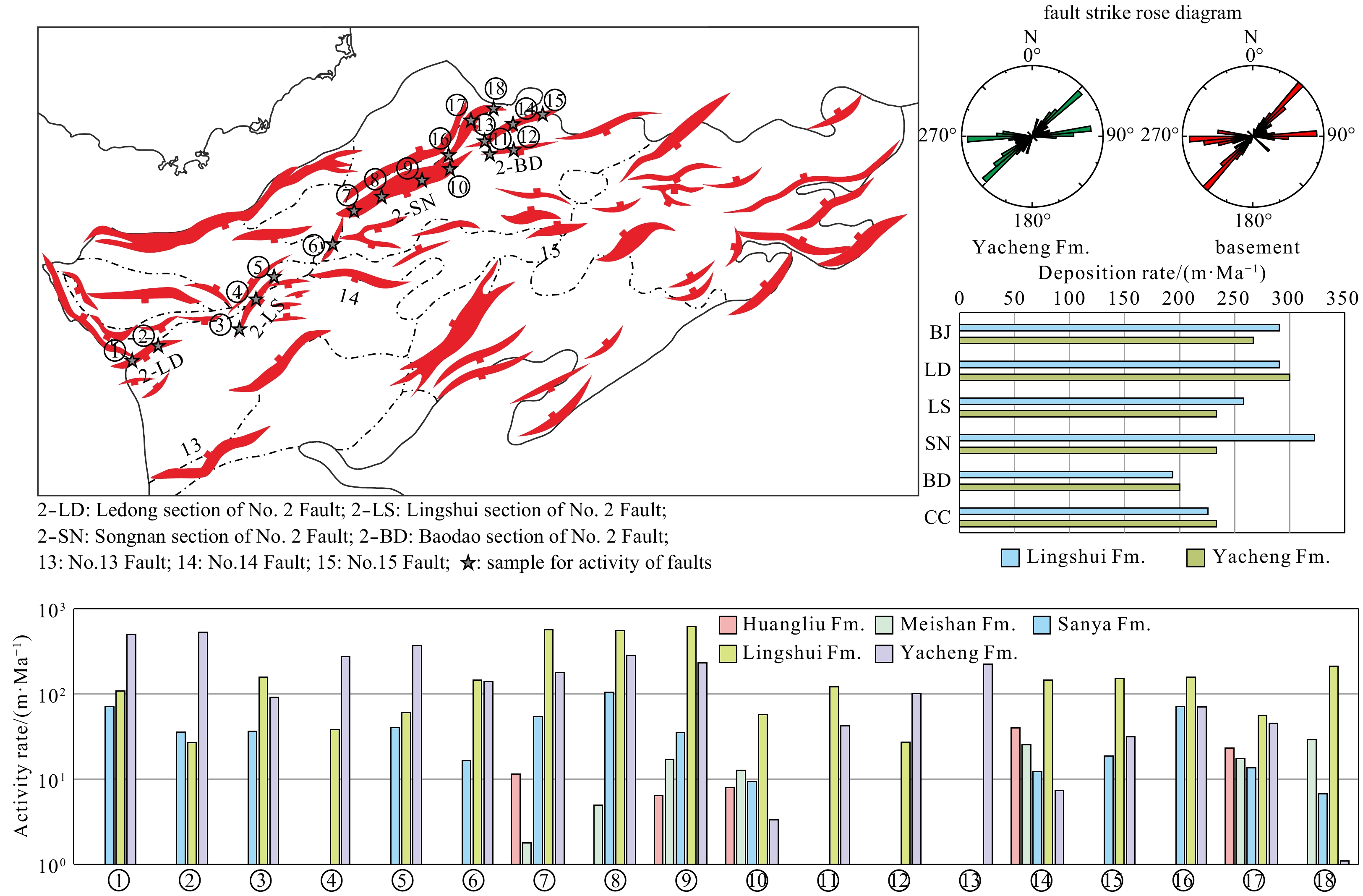
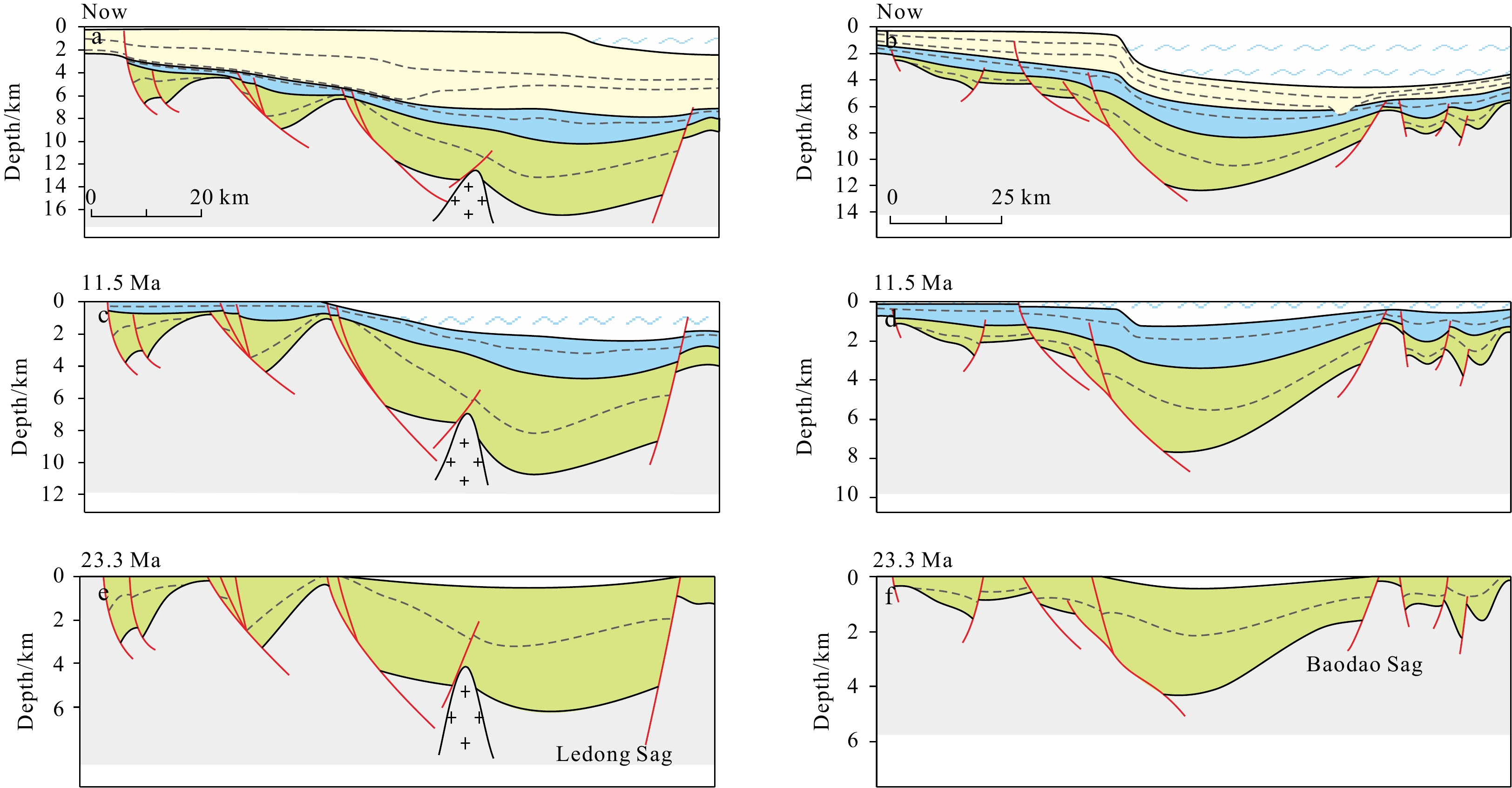
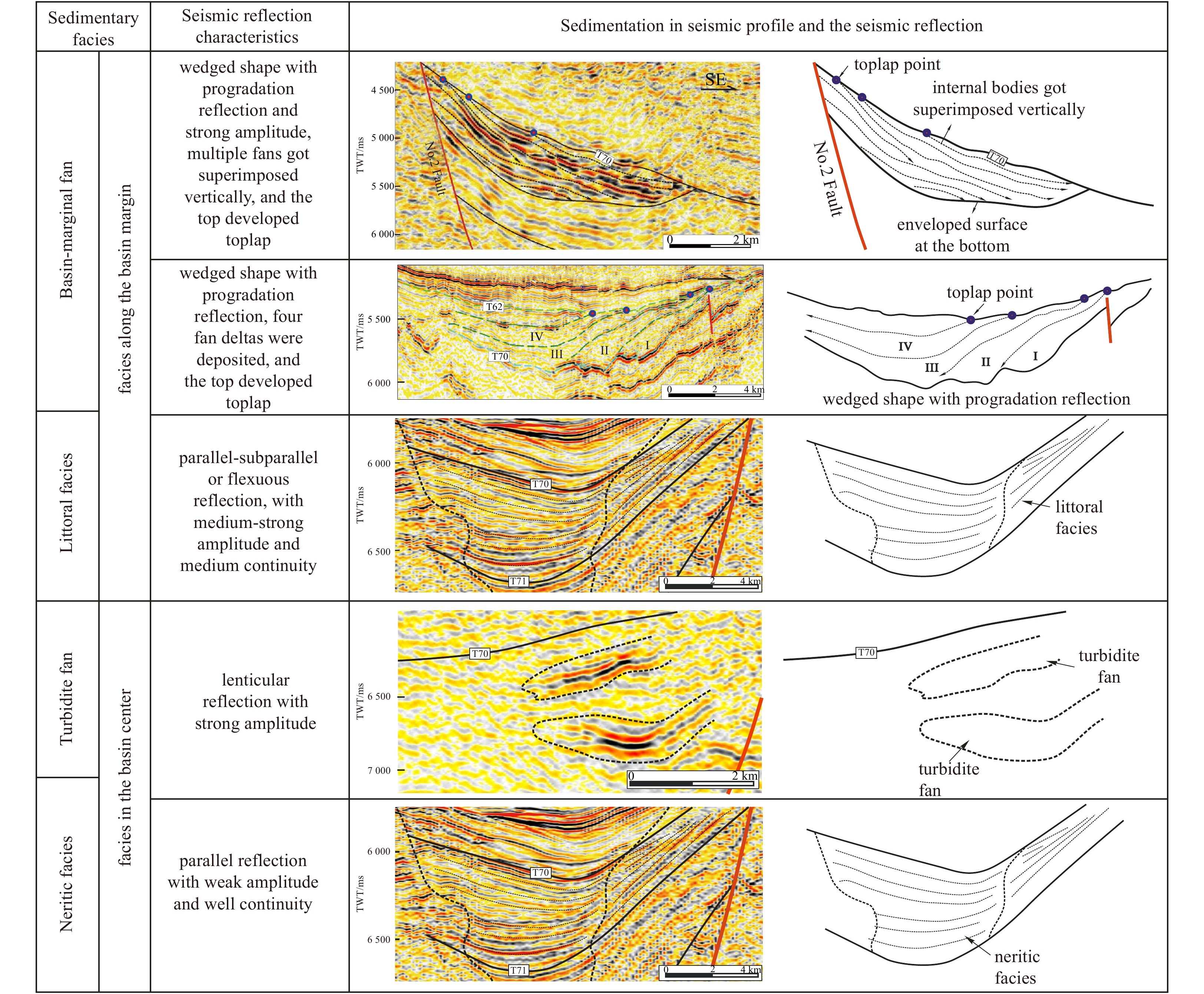
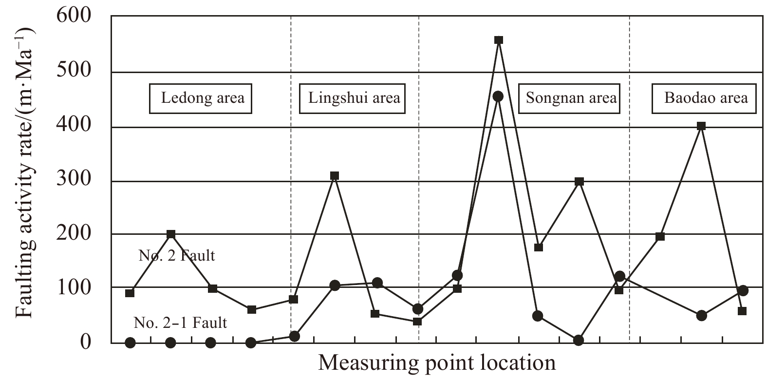
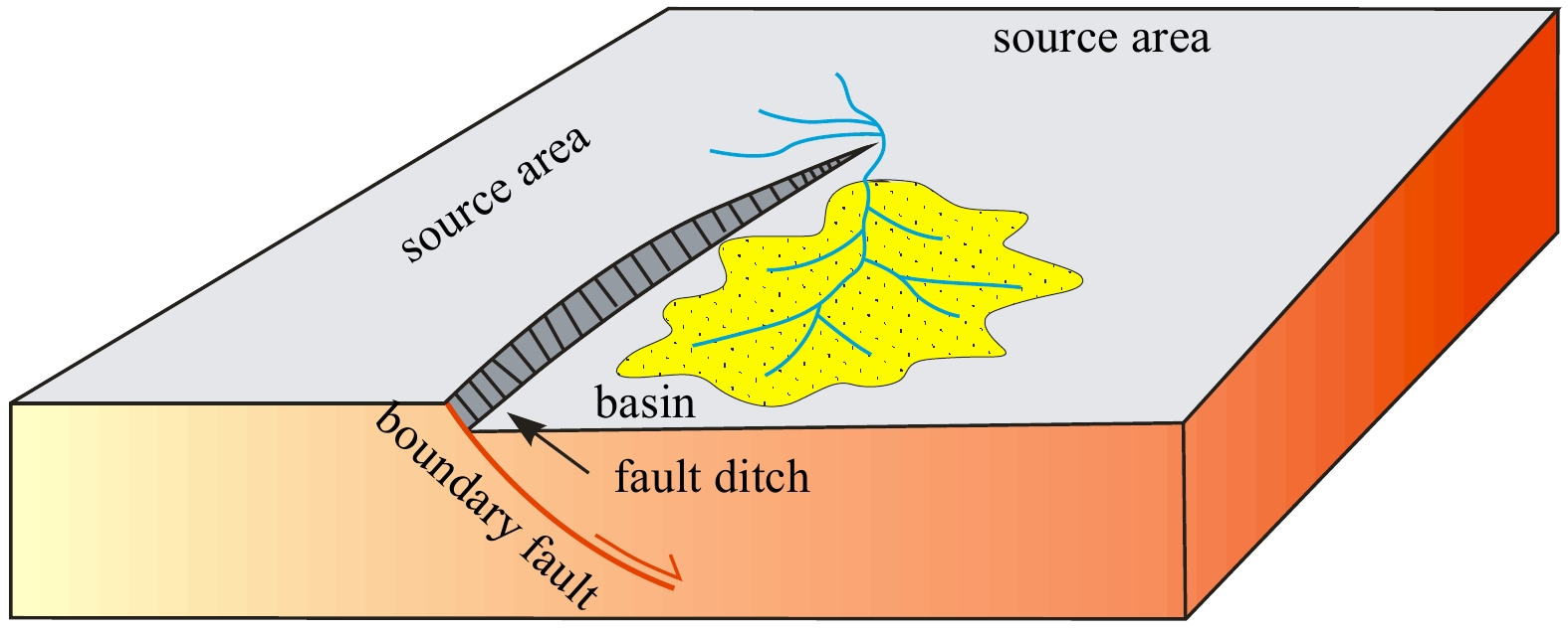
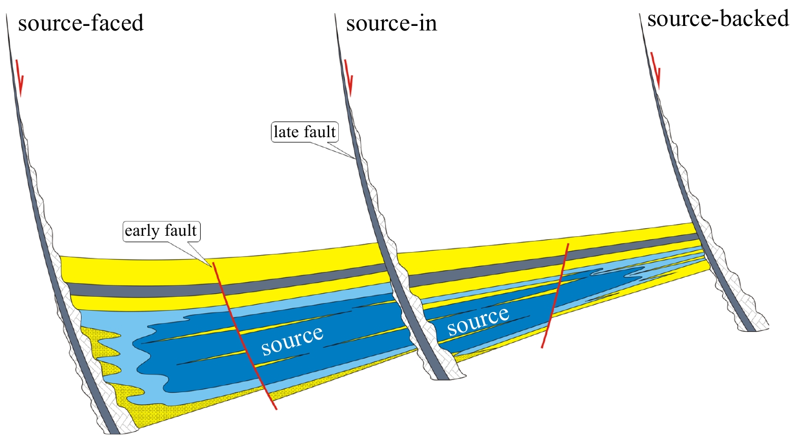
The synsedimentary faults and basin-marginal fans located in the central part of the deep-water area of the early Oligocene Qiongdongnan Basin have been investigated using seismic profiles, boreholes, and well-log data. Through the formations of the characterized paleogeomorphology, such as transverse anticlines, fault ditches, and step-fault belts, the synsedimentary faults are known to have controlled the development position, distribution direction, and extension scales of the basin-marginal fans. For example, at the pitching ends of two adjacent faults, transverse anticlines developed, which controlled the development positions and distributions of the fans. During the early Oligocene, the faults controlled the subsidence center, and fault ditches were formed at the roots of the faults. In the surrounding salient or low salient areas, which were exposed as provenance areas during early Oligocene, the fault ditches acted as the source channels and determined the flow paths of the clastics, where incised valley fills were obviously developed. The fault ditches which developed in the sedimentary basins were able to capture the drainage systems and influenced the distributions of the fans. The large boundary faults and the secondary faults generated two fault terraces and formed step-fault belts. The first fault terrace caused the clastics to be unloaded. As a result, fans were formed at the entrance to the basin. Then, the second fault terrace caused the fans to move forward, with the fans developing in a larger extension scale. The results obtained in this study will potentially be beneficial in the future prospecting activities for reservoirs and coal-measure source rocks in the basins located in the deep-water areas of the South China Sea.
Characteristics and origins of middle Miocene mounds and channels in the northern South China Sea
Yufeng Li, Gongcheng Zhang, Renhai Pu, Hongjun Qu, Huailei Shen, Xueqin Zhao
2021, 40(2): 65-80. doi: 10.1007/s13131-021-1759-5
Abstract:
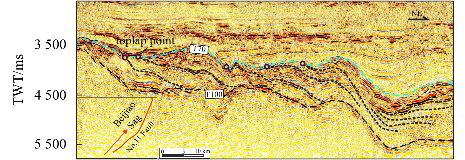
Numerous elongated mounds and channels were found at the top of the middle Miocene strata using 2D/3D seismic data in the Liwan Sag of Zhujiang River Mouth Basin (ZRMB) and the Beijiao Sag of Qiongdongnan Basin (QDNB). They occur at intervals and are rarely revealed by drilling wells in the deepwater areas. Origins of the mounds and channels are controversial and poorly understood. Based on an integrated analysis of the seismic attribute, palaeotectonics and palaeogeography, and drilling well encountering a mound, research results show that these mounds are dominantly distributed on the depression centres and/or slopes of the Liwan and Beijiao sags and developed in a bathyal sedimentary environment. In the Liwan and Beijiao sags, the mounds between channels (sub) parallel to one another are 1.0–1.5 km and 1.5–2.0 km wide, 150–300 m and 150–200 m high, and extend straightly from west to east for 5–15 km and 8–20 km, respectively. Mounds and channels in the Liwan Sag are parallel with the regional slope. Mounds and channels in the Beijiao Sag, however, are at a small angle to the regional slope. According to internal geometry, texture and external morphology of mounds, the mounds in Beijiao Sag are divided into weak amplitude parallel reflections (mound type I), blank or chaotic reflections (mound type II), and internal mounded reflections (mound type III). The mounds in Liwan Sag, however, have the sole type, i.e., mound type I. Mound type I originates from the incision of bottom currents and/or gravity flows. Mound type II results from gravity-driven sediments such as turbidite. Mound type III is a result of deposition and incision of bottom currents simultaneously. The channels with high amplitude between mounds in the Beijiao and Liwan sags are a result of gravity-flow sediments and it is suggested they are filled by sandstone. Whereas channels with low-mediate amplitudes are filled by bottom-current sediments only in the Beijiao Sag, where they are dominantly composed of mudstone. This study provides new insights into the origins of the mounds and channels worldwide.
Migrated hybrid turbidite-contourite channel-lobe complex of the late Eocene Rovuma Basin, East Africa
Yintao Lu, Xiwu Luan, Boqing Shi, Weimin Ran, Fuliang Lü, Xiujuan Wang, Quanbin Cao, Xiaoyong Xu, Hui Sun, Genshun Yao
2021, 40(2): 81-94. doi: 10.1007/s13131-021-1750-1
Abstract:
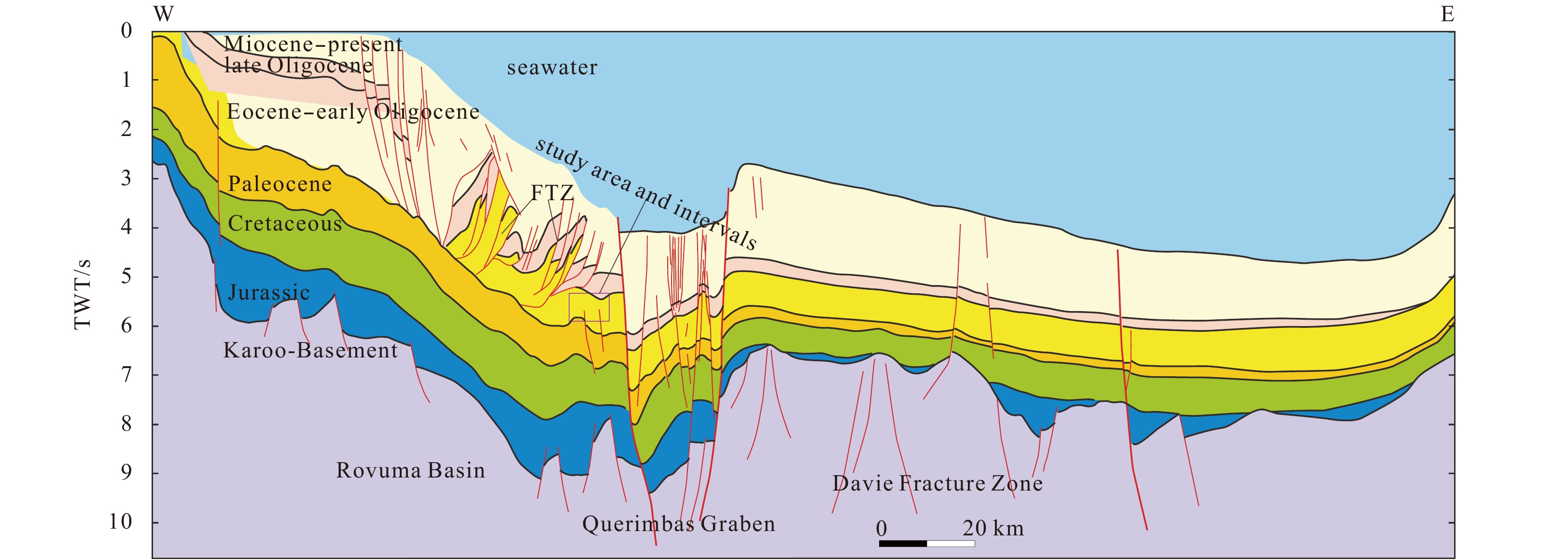
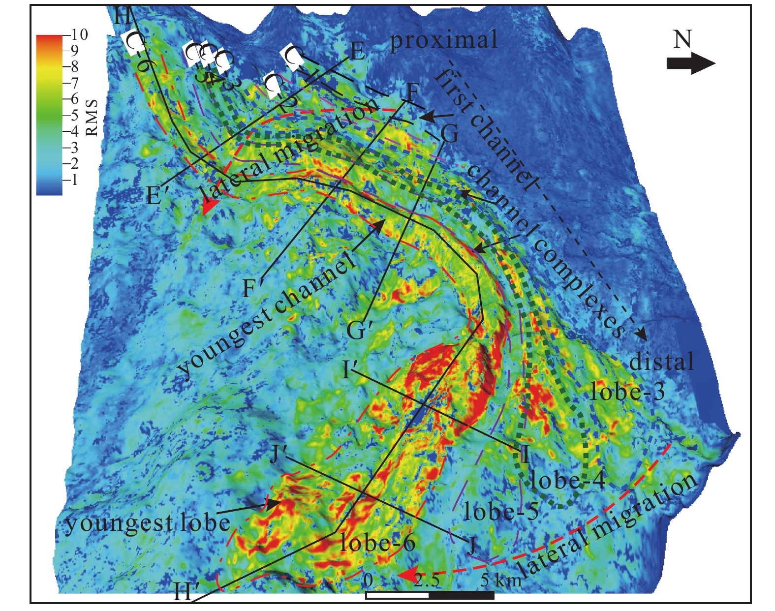
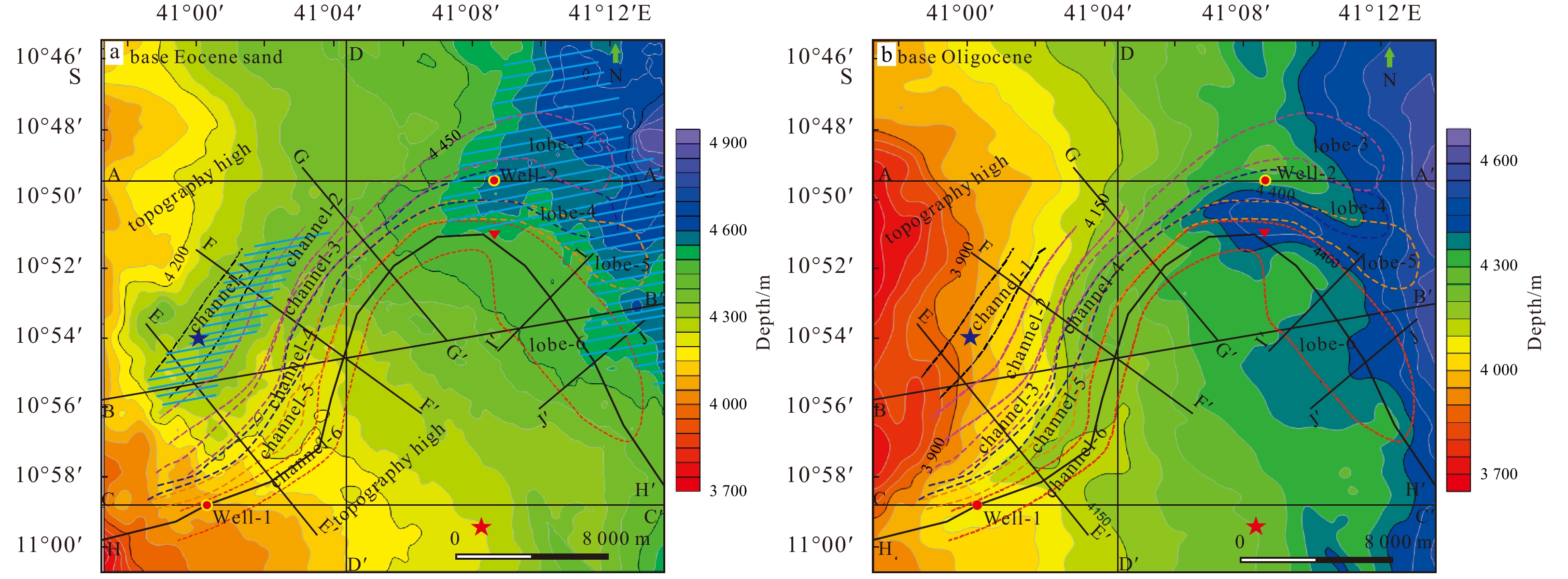
Analysis of 3D seismic data and well log data from the Rovuma Basin in East Africa reveals the presence of a late Eocene channel-lobe complex on its slope. The first two channels, denoted as channel-1 and channel-2, are initiated within a topographic low on the slope but come to a premature end when they are blocked by a topographic high in the northwest region of the basin. New channels migrate southeastward from channel-1 to channel-6 due to the region’s sufficient sediment supply and stripping caused by bottom currents. The primary factors controlling the development of the channel complex include its initial paleo-topographic of seafloor, the property of gravity flows, the direction of the bottom current, and the stacking and expansion of its levees. The transition zone from channel to lobe can also be clearly identified from seismic sections by its pond-shaped structure. At a certain point, thest systems record a transiton from erosive features to sedimentary features, and record a transition from a confined environment to an open environment. Channels and lobes can be differentiated by their morphologies: thick slump-debris flows are partly developed under channel sand sheets, whereas these slump-debris flows are not very well developed in lobes. Well log responses also record different characteristics between channels and lobes. The interpreted shale volume throughout the main channel records a box-shaped curve, thereby implying that confined channel complexes record high energy currents and abundant sand supply, whereas the interpreted shale volume throughout the lobe records an upward-fining shape curve, thereby indicating the presence of a reduced-energy current in a relatively open environment. Within the Rovuma Basin of East Africa, the average width of the Rovuma shelf is less than 10 km, the width of the slope is only approximately 40 km, and the slope gradient is 2°–4°. Due to this steep slope gradient, the sand-rich top sheet within the channel also likely contributes to the straight feature of the channel system. It is currently unclear whether the bottom current has any effect on its sinuosity.
Peat formation and accumulation mechanism in northern marginal basin of South China Sea
Zengxue Li, Qingbo Zeng, Meng Xu, Dongdong Wang, Guangzeng Song, Pingli Wang, Xiaojing Li, Xue Zheng
2021, 40(2): 95-106. doi: 10.1007/s13131-021-1748-8
Abstract:
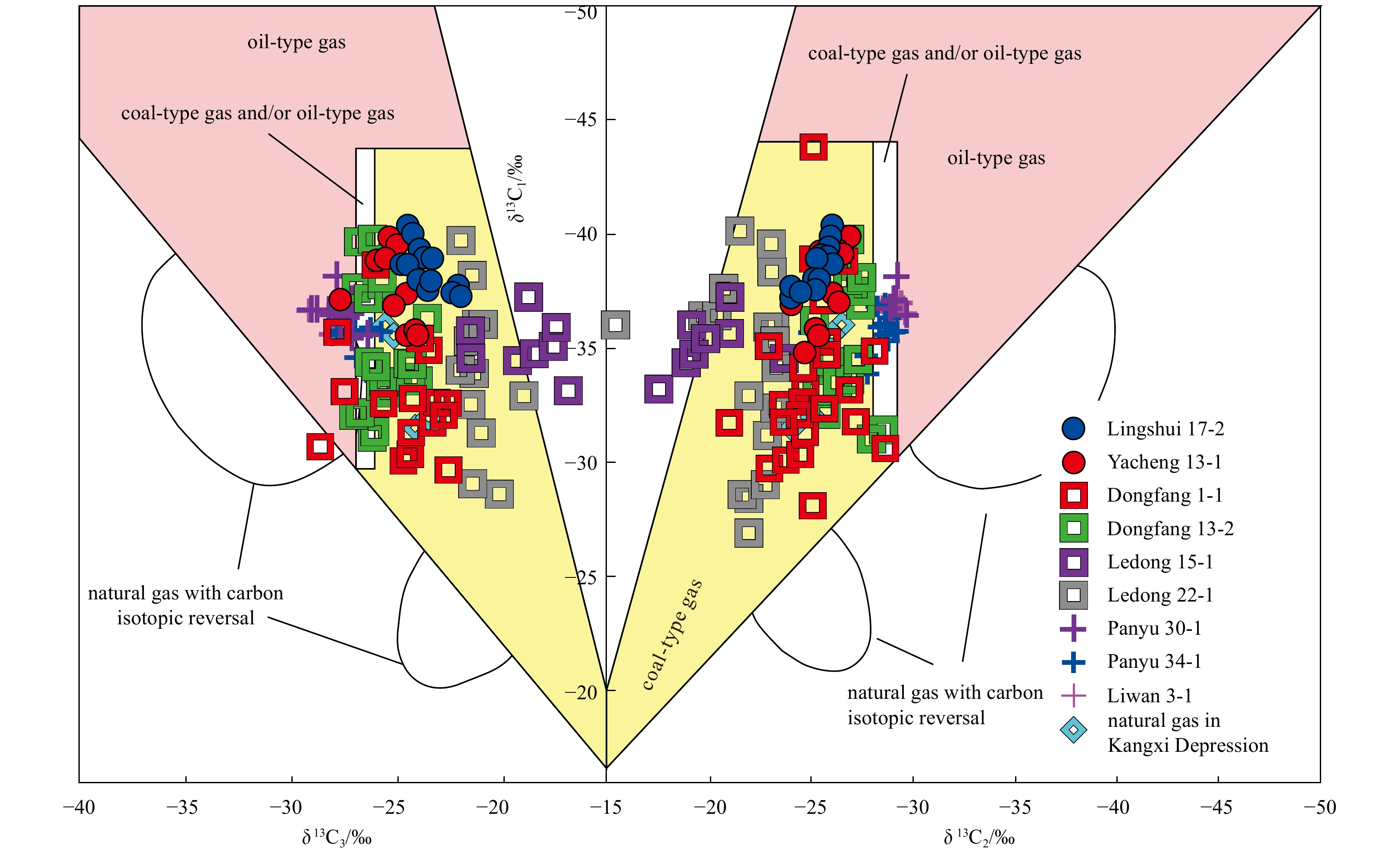
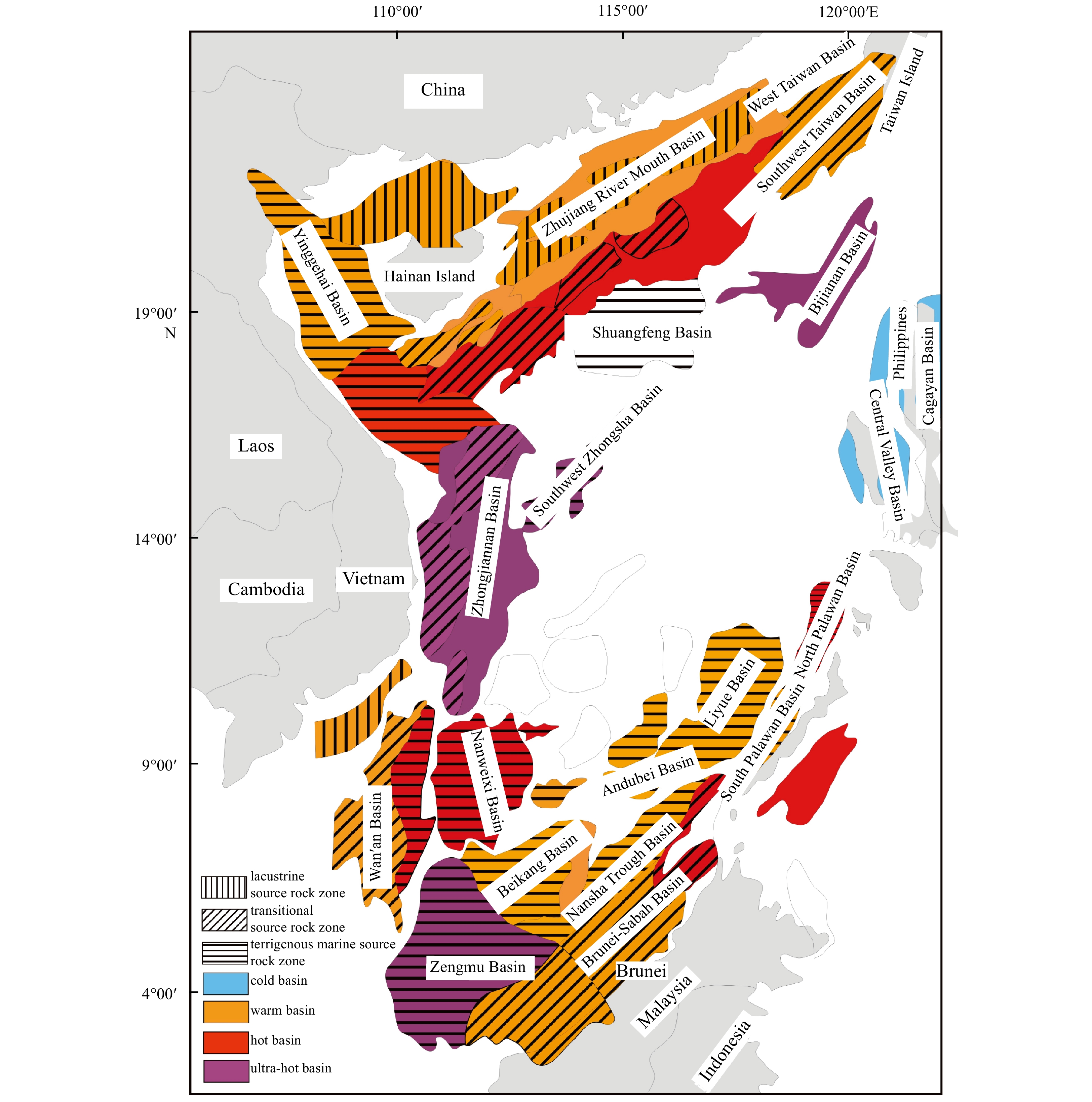
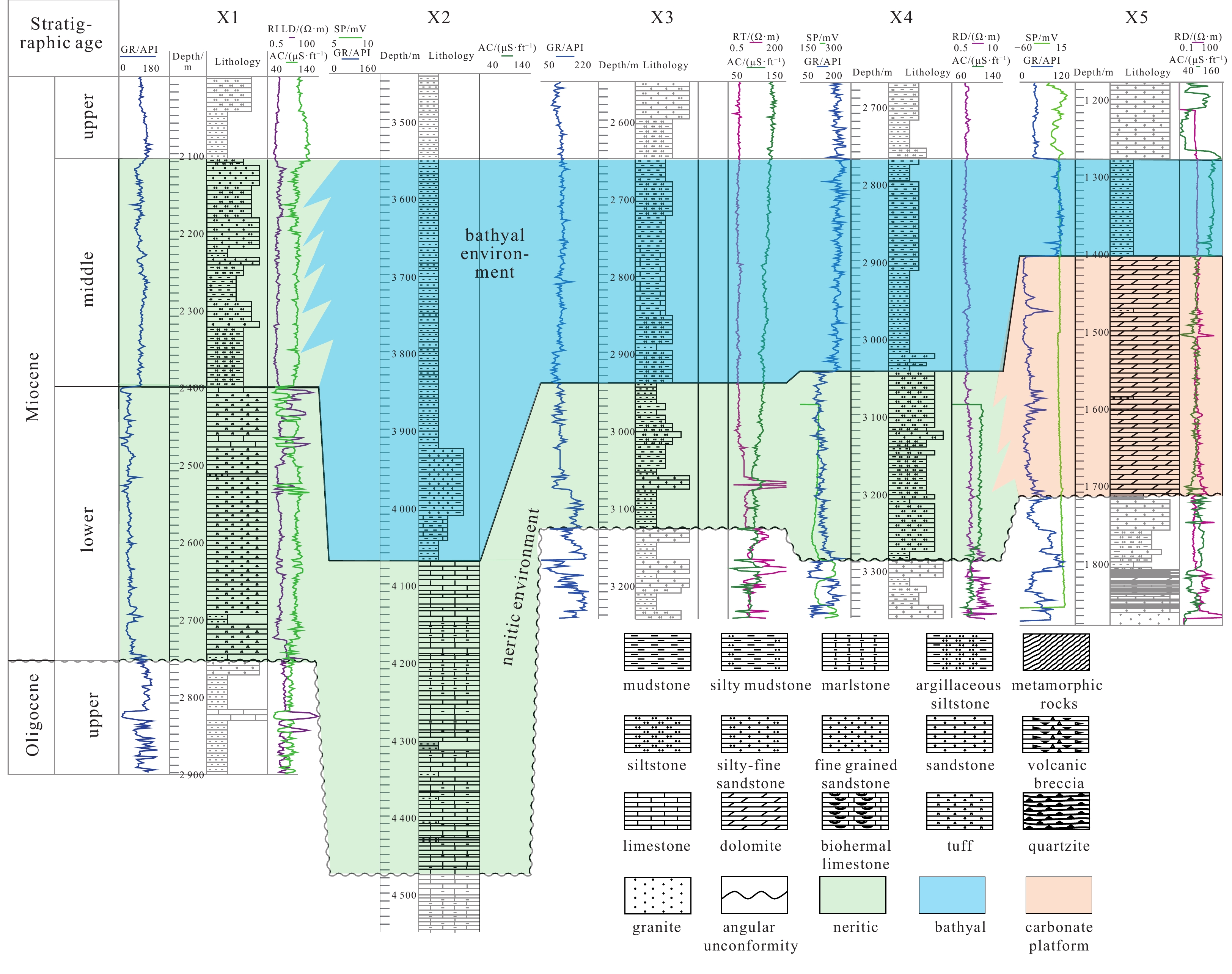
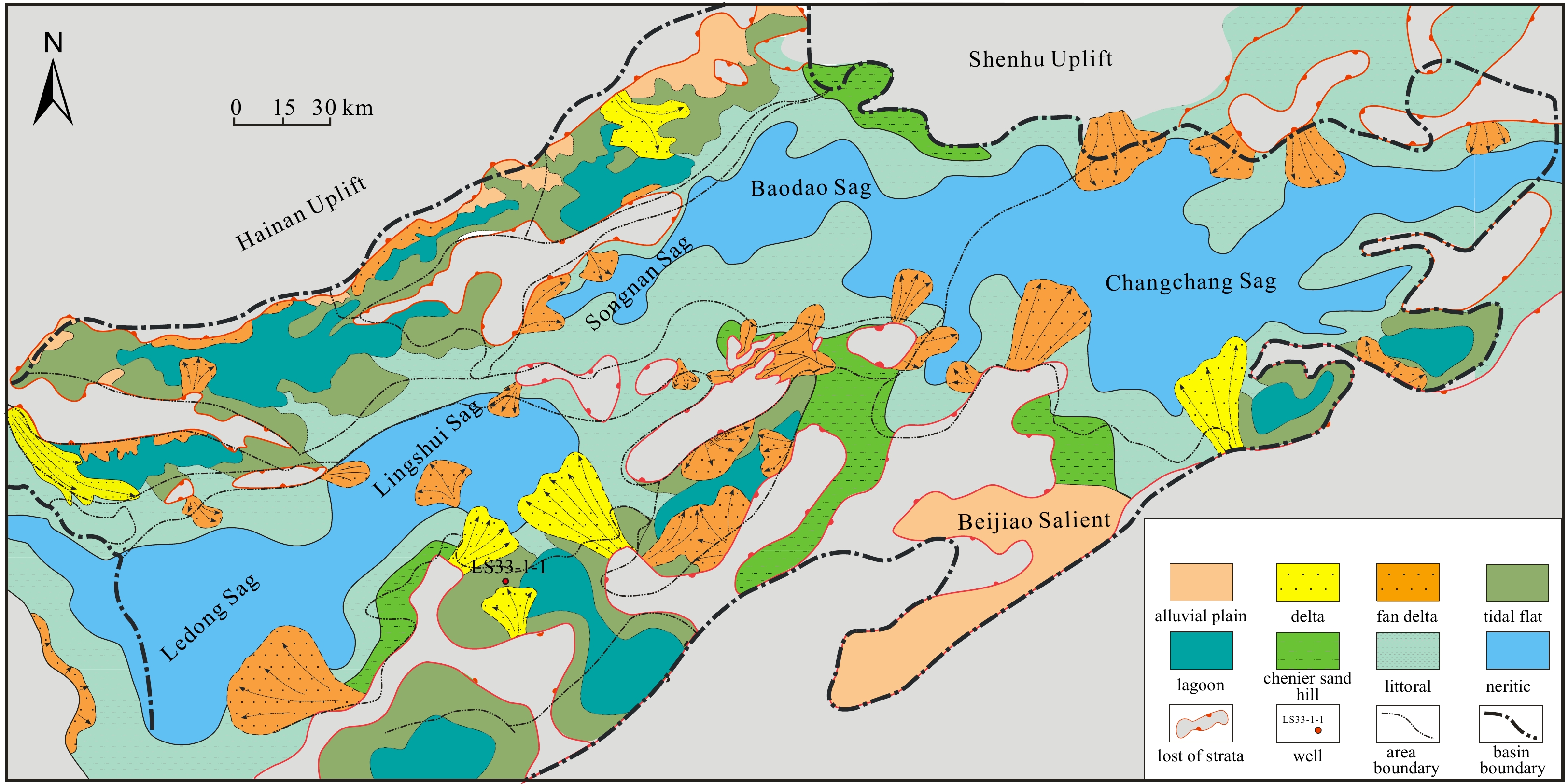
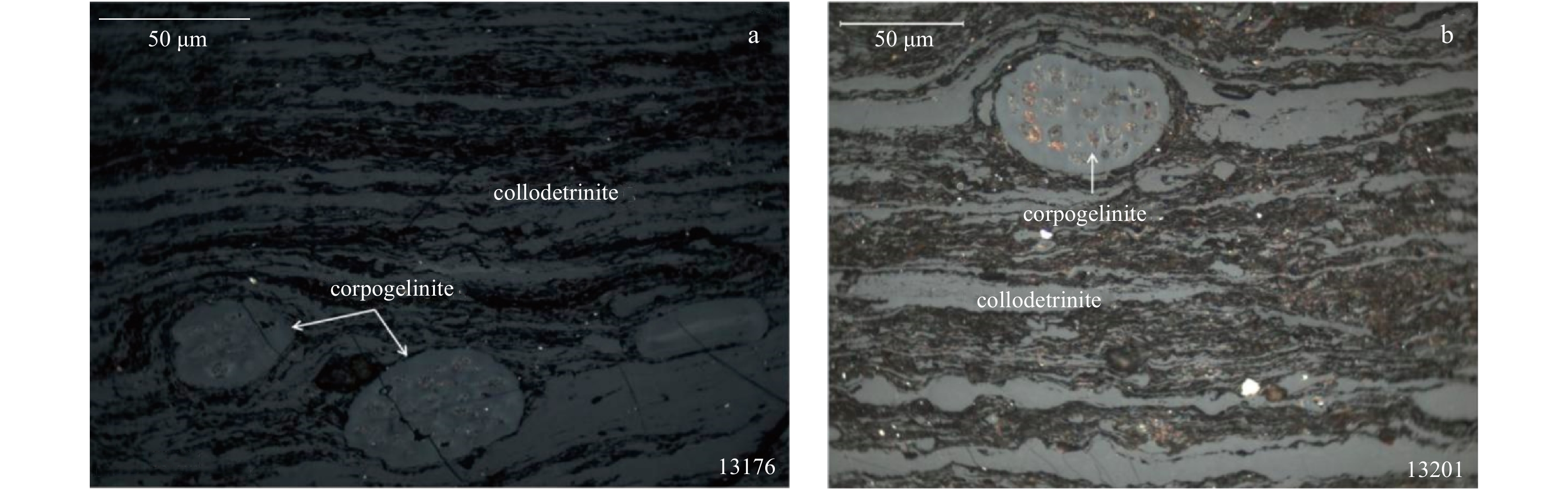
In the present study, the coal-rock organic facies of Oligocene Yacheng Formation of the marginal basin in the South China Sea were classified and divided. In addition, through the correlations of the large-scale coal-bearing basins between the epicontinental sea and the South China Sea, it was concluded that the coal forming activities in the South China Sea presented particularity and complexity. Furthermore, the coal forming mechanisms also presented distinctiveness. The marginal basins in the South China Sea consist of several large and complex rift or depression basins, which are distributed at different tectonic positions in the South China Sea. Therefore, the marginal basins in the South China Sea are not simple traditional units with onshore continental slopes extending toward the deep sea. The marginal basins are known to consist of multi-level structures and distinctive types of basins which differ from the continental regions to the sea. During the Oligocene, the existing luxuriant plants and beneficial conditions assisted in the development of peat. Therefore, the Oligocene was the significant period for the formation and aggregation of the peat. However, the peat did not form in unified sedimentary dynamic fields, but instead displayed multi-level geographical units, multiple provenance areas, instability, and nonevent characteristics. As a result, the marginal basins in the South China Sea are characterized by non-uniform peat aggregation stages. In another words, the majority of the peat had entered the marine system in a dispersive manner and acted as part of the marine deposits, rather than during one or several suitable coal-forming stages. These peat deposits then became the main material source for hydrocarbon generation in all of the marginal basins of the South China Sea. The study will be of much significance for the hydrocarbon exploration in the marginal basins of the South China Sea.
Study on fault-controlled hydrocarbon migration and accumulation process and models in Zhu I Depression
Wenqi Zhu, Keqiang Wu, Ling Ke, Kai Chen, Zhifeng Liu
2021, 40(2): 107-113. doi: 10.1007/s13131-021-1755-9
Abstract:
Through the analysis of the faults and their internal structure in Zhu I Depression, it is found that the internal structure of the late fault is obviously segmented vertically. It develops unitary structure (simple fault plane) in shallow layers, binary structure (induced fracture zone in hanging wall and sliding fracture zone in footwall) in middle, layers and ternary structure (induced fracture zone in hanging wall and sliding fracture zone in middle, and induced fracture zone in footwall) in deep layers. Because the induced fracture zone is a high porosity and permeability zone, and the sliding fracture zone is a low porosity and ultra-low permeability zone, the late fault in middle layers has the character of “transporting while sealing”. The late fault can transport hydrocarbon by its induced fracture zone in the side of the hanging wall and seal hydrocarbon by its sliding fracture zone in the side of the footwall. In deep layers, the late fault has the character of “dual-transportation”, induced fracture zones in both sides of hanging wall and footwall can transport hydrocarbon. The early fault that only developed in the deep layers is presumed to be unitary structure, which plays a completely sealing role in the process of hydrocarbon migration and accumulation due to inactivity during the hydrocarbon filling period. Controlled by hydrocarbon source, early/late faults, sand bodies and traps, two reservoir-forming models of “inverted L” and “stereo-spiral” can be proposed in middle layers, while two reservoir-forming models of “cross fault” and “lateral fault sealing” are developed in the deep layers of Zhu I Depression.
Sediment source and environment evolution in Taiwan Island during the Eocene–Miocene
Yuanli Hou, Weilin Zhu, Peijun Qiao, Chi-Yue Huang, Yuchi Cui, Xianbo Meng
2021, 40(2): 114-122. doi: 10.1007/s13131-021-1756-8
Abstract:
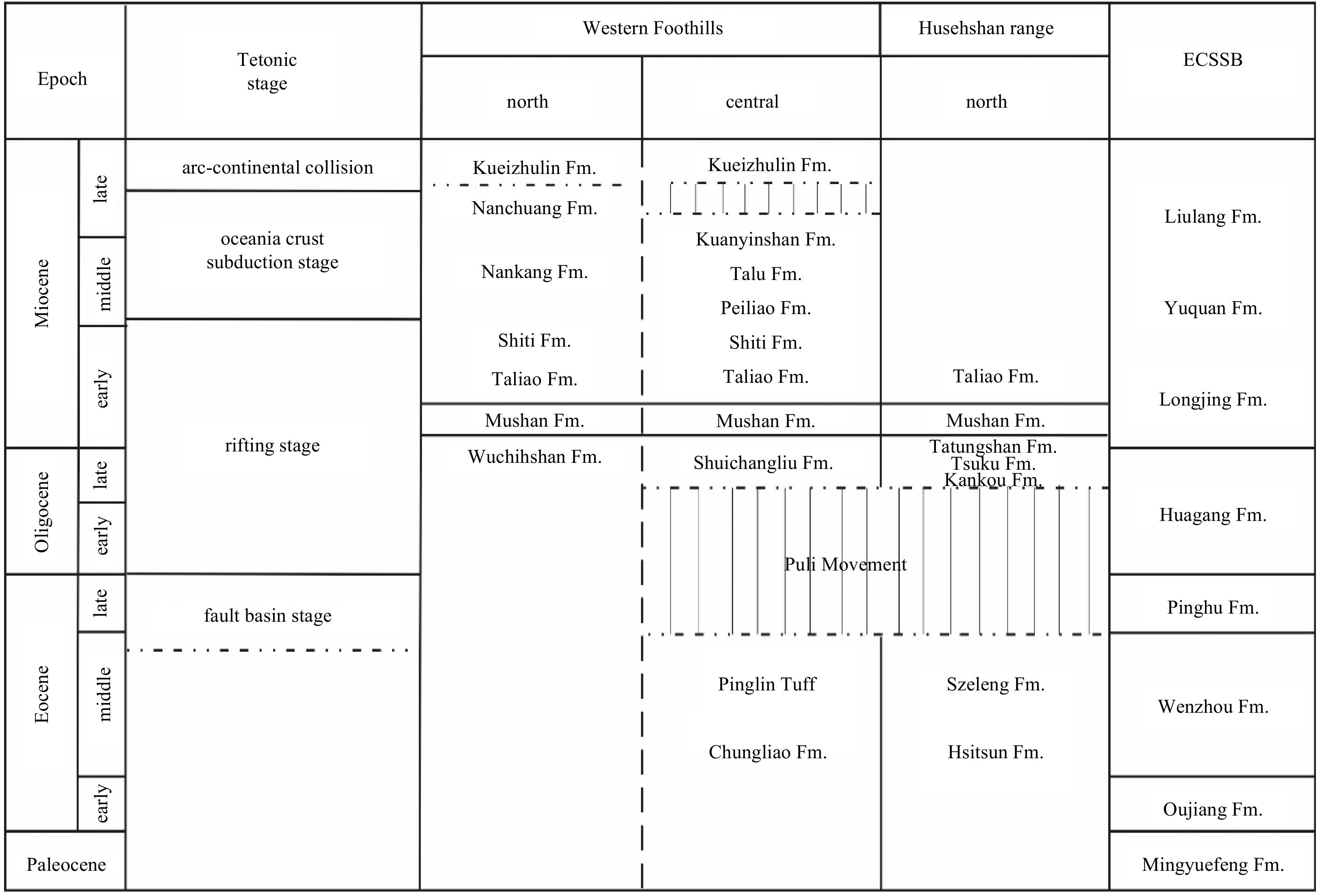
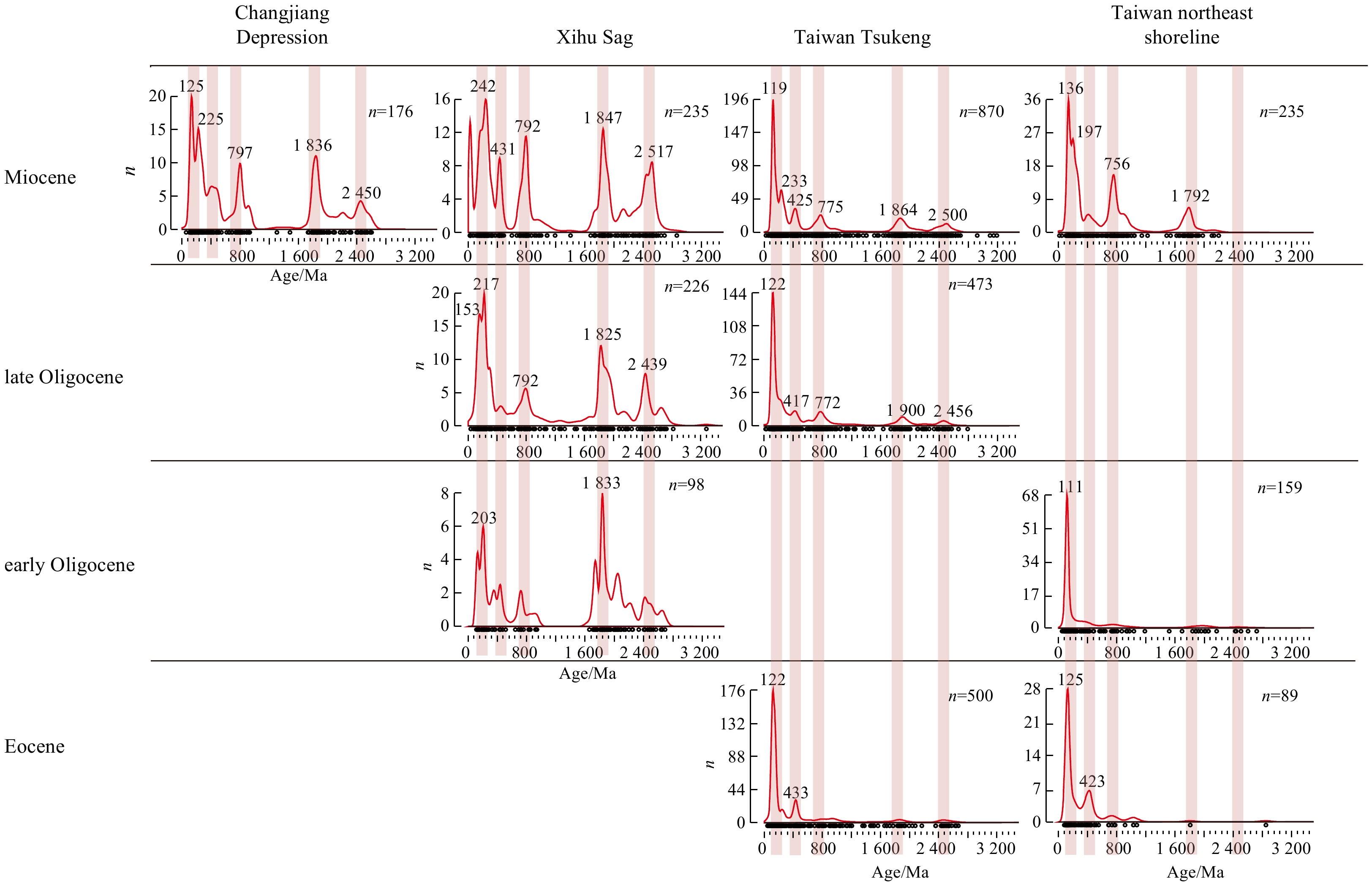
Taiwan Island’s outcropping strata can provide important insights into the sedimentary environment and source development of the southeast China margin. This research is based on the Eocene–Miocene strata of the Tsukeng area in the central Western Foothills, northeast shoreline of Taiwan Island and two sites of the East China Sea Shelf Basin (ECSSB), using petrology and detrital zircon U-Pb age for the analysis. Results show that central and northeast Taiwan Island experienced a transformation from continental to marine facies during the Eocene–Miocene, and the sandstone maturity changed with time. Source analysis shows that sediments from the Eocene–early Oligocene strata mainly originated from near-source Mesozoic rocks, whose zircon age is consistent with the igneous rock in the surrounding area and coastal Cathaysia, showing 120 Ma and 230 Ma peaks in the age spectrum diagram. Since the late Oligocene, peaks of 900 Ma and 1 800 Ma are seen, indicating that deposition of matter from the old block began. The sediments could be a mixture of the surrounding Mesozoic volcanic and fewer pre-Cambrian rocks sourced from the coastal river and sporadic old basement in the ECSSB instead of long-distance transportation.
Geochemistry and zircon U-Pb ages of the Oligocene sediments in the Baiyun Sag, Zhujiang River Mouth Basin
Rui Sun, Ming Ma, Kai Zhong, Xiayang Wang, Zhao Zhao, Shuai Guo, Xingzong Yao, Gongcheng Zhang
2021, 40(2): 123-135. doi: 10.1007/s13131-020-1628-7
Abstract:
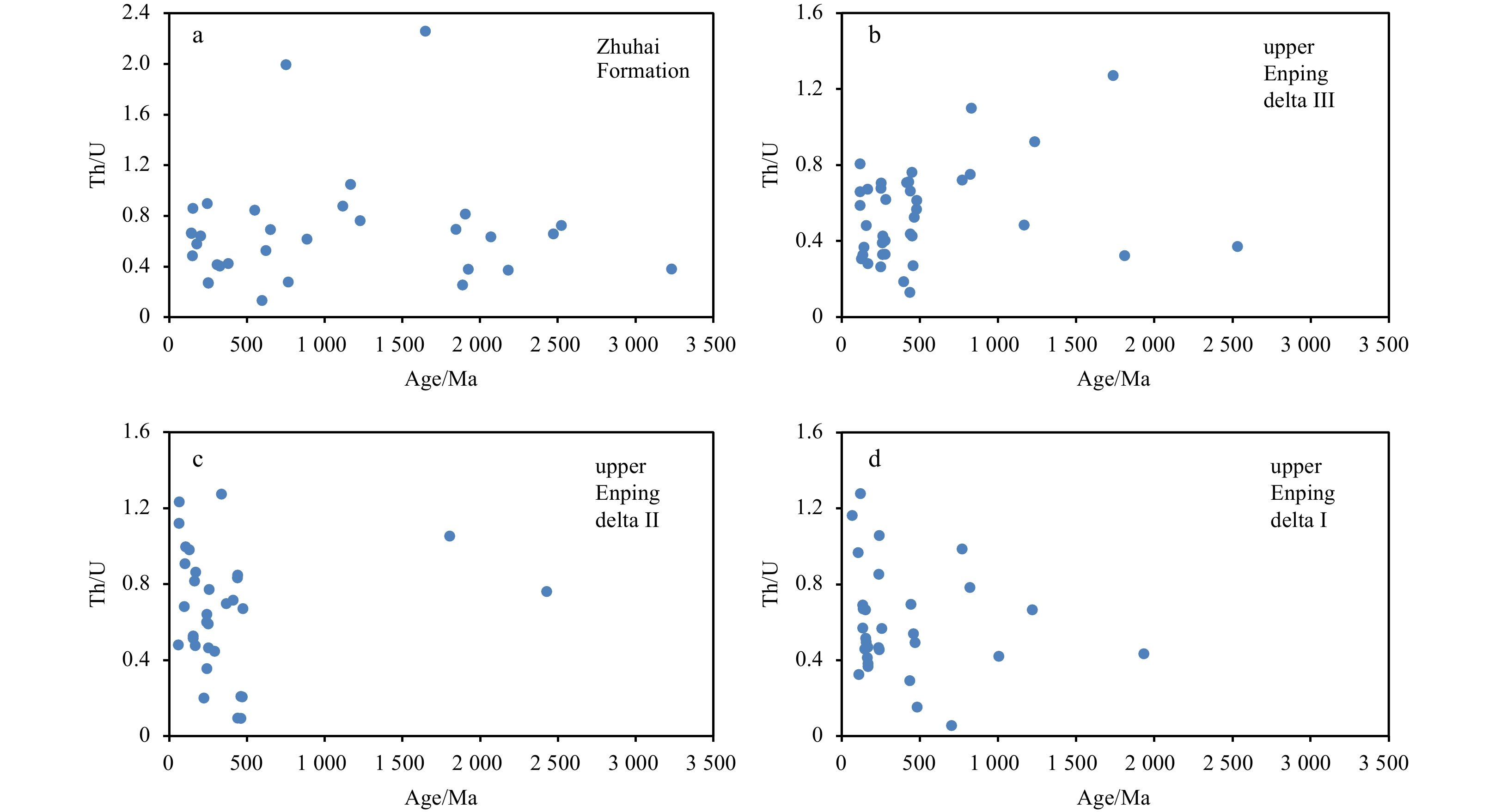
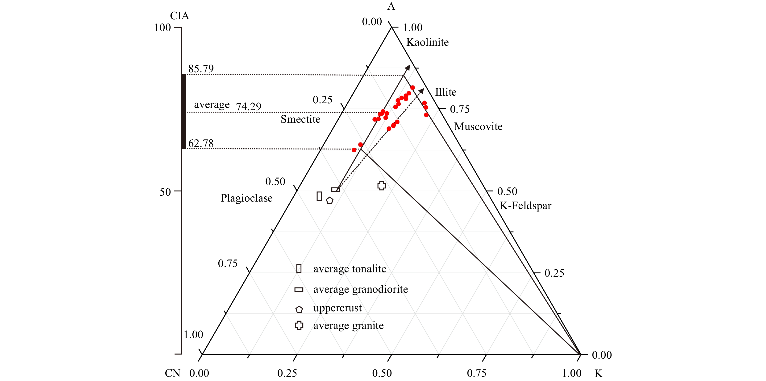
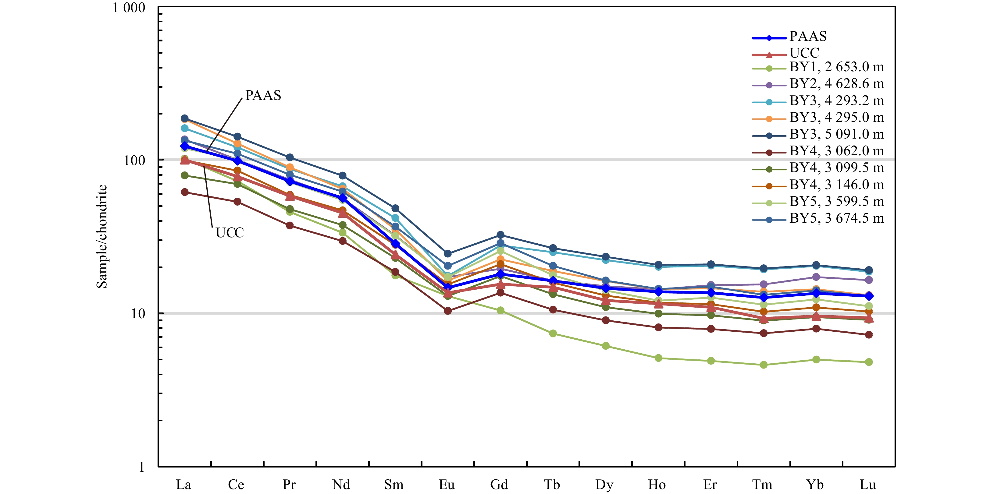
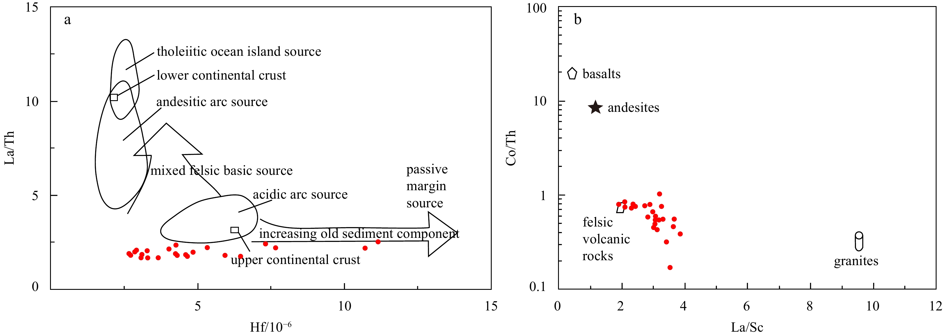
In this study, element geochemistry and zircon chronology are used to analyze the Oligocene sediments in the Baiyun Sag, Zhujiang River Mouth Basin. The experimental results are discussed with respect to weathering conditions, parent rock lithologies, and provenances. The chemical index of alteration and the chemical index of weathering values of mudstone samples from the lower Oligocene Enping Formation indicate that clastic particles in the study area underwent moderate weathering. Mudstone samples exhibit relatively enriched light rare earth elements and depleted heavy rare earth elements, “V”-shaped negative Eu anomalies, and negligible Ce anomalies. The rare earth element distribution curves are obviously right-inclined, with shapes and contents similar to those of post-Archean Australian shale and upper continental crust, indicating that the samples originated from acid rocks in the upper crust. The Hf-La/Th and La/Sc-Co/Th diagrams show this same origin for the sediments in the study area. For the samples from the upper Enping deltas, the overall age spectrum shows four major age peaks ca. 59–68 Ma, 98–136 Ma, 153–168 Ma and 239–260 Ma. For the Zhuhai Formation samples, the overall age spectrum shows three major age peaks ca. 149 Ma, 252 Ma and 380 Ma. The detrital zircon shapes and U-Pb ages reveal that during Oligocene sedimentation, the sediments on the northwestern margin of the Baiyun Sag were supplied jointly from two provenances: Precambrian-Paleozoic metamorphic rocks in the extrabasinal South China fold zone and Mesozoic volcanic rocks in the intrabasinal Panyu Low Uplift, and the former supply became stronger through time. Thus, the provenance of the Oligocene deltas experienced a transition from an early proximal intrabasinal source to a late distal extrabasinal source.
An insight into shallow gas hydrates in the Dongsha area, South China Sea
Bin Liu, Jiangxin Chen, Luis M. Pinheiro, Li Yang, Shengxuan Liu, Yongxian Guan, Haibin Song, Nengyou Wu, Huaning Xu, Rui Yang
2021, 40(2): 136-146. doi: 10.1007/s13131-021-1758-6
Abstract:
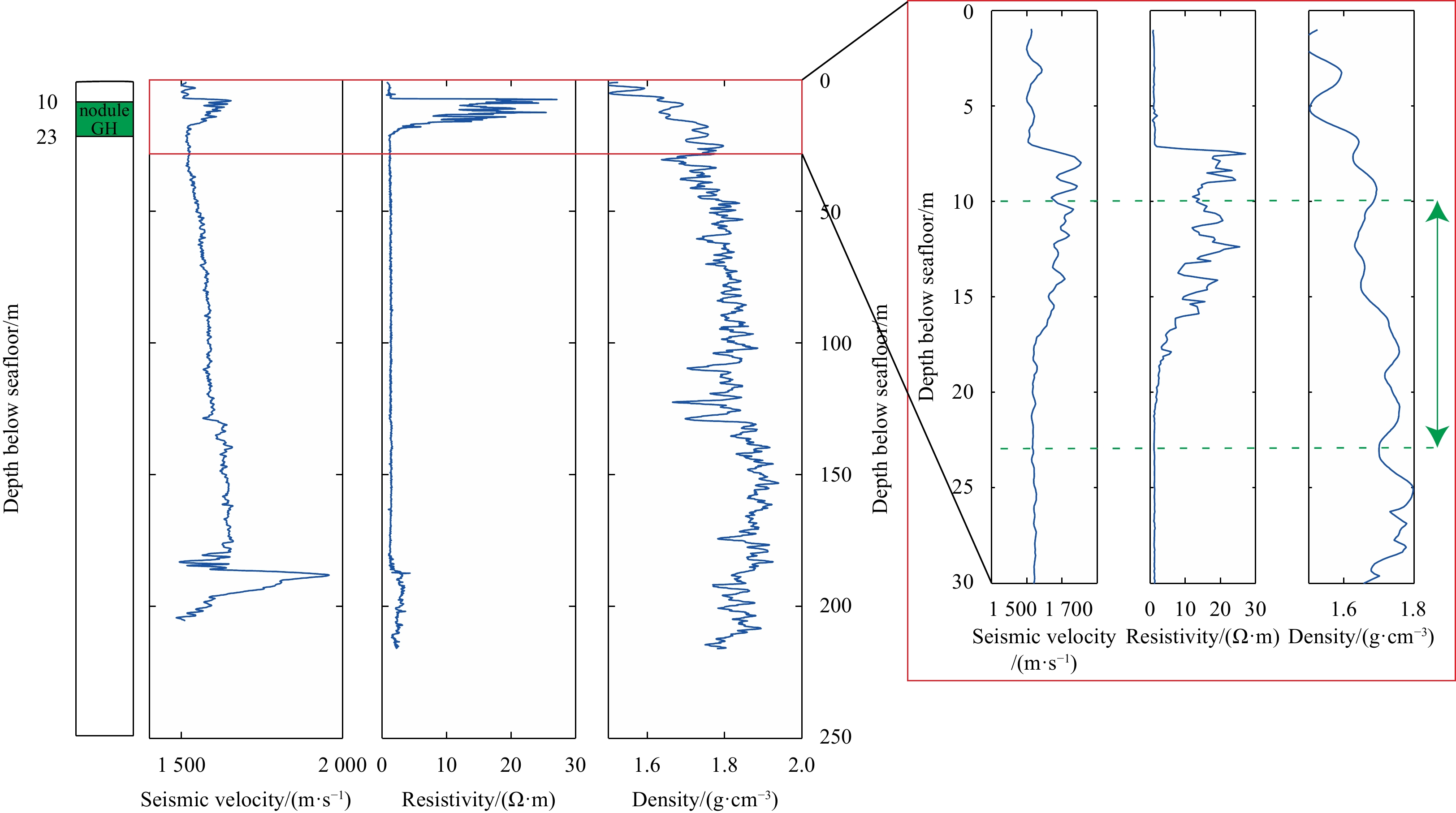
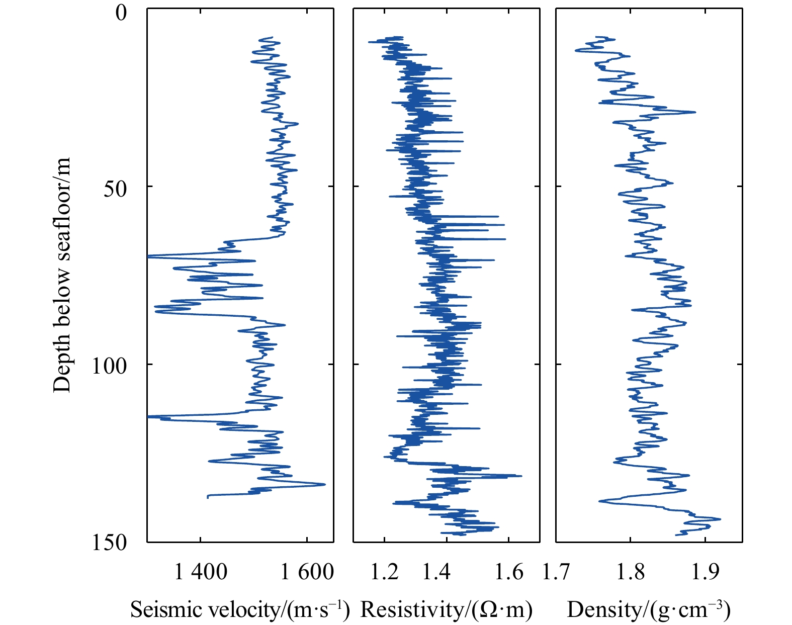
Previous studies of gas hydrate in the Dongsha area mainly focused on the deep-seated gas hydrates that have a high energy potential, but cared little about the shallow gas hydrates occurrences. Shallow gas hydrates have been confirmed by drill cores at three sites (GMGS2 08, GMGS2 09 and GMGS2 16) during the GMGS2 cruise, which occur as veins, blocky nodules or massive layers, at 8–30 m below the seafloor. Gas chimneys and faults observed on the seismic sections are the two main fluid migration pathways. The deep-seated gas hydrate and the shallow hydrate-bearing sediments are two main seals for the migrating gas. The occurrences of shallow gas hydrates are mainly controlled by the migration of fluid along shallow faults and the presence of deep-seated gas hydrates. Active gas leakage is taking place at a relatively high-flux state through the vent structures identified on the geophysical data at the seafloor, although without resulting in gas plumes easily detectable by acoustic methods. The presence of strong reflections on the high-resolution seismic profiles and dim or chaotic layers in the sub-bottom profiles are most likely good indicators of shallow gas hydrates in the Dongsha area. Active cold seeps, indicated by either gas plume or seepage vent, can also be used as indicators for neighboring shallow gas hydrates and the gas hydrate system that is highly dynamic in the Dongsha area.