State Key Laboratory of Marine Environmental Science, College of Ocean and Earth Sciences, Xiamen University, Xiamen 361102, China
2.
Southern Marine Science and Engineering Guangdong Laboratory (Zhuhai), Zhuhai 519000, China
Funds:
The National Basic Research Program of China under contract No. 2015CB954004; the National Natural Science Foundation of China under contract Nos 41606009, 41776027, 91858201 and 41890801; the Xiamen University Fundamental Research Funds for the Central Universities under contract No. 20720180099; the municipal project of Huizhou City under contract No. F2017-01-1; the Laboratory for Regional Oceanography and Numerical Modeling, Pilot National Laboratory for Marine Science and Technology (Qingdao) under contract No. 2017A02.
This study introduces a type of self-developed, GPS-based, simple and cheap Surface Current Experiment (SUCE) drifters designated for observing surface coastal currents. By examining trajectories of six drifters deployed in the Daya Bay and the drifter-derived velocities, we conclude that such drifters are generally capable of capturing the characteristics of wintertime surface coastal currents along the Guangdong coast.
Measurements of ocean velocities are of great importance in terms of advancing our understanding of ocean circulations. Velocity observations in the pre-satellite era relied primarily on sporadic ship-borne devices, which were incapable of providing overall pictures of large-scale or even regional-scale circulations. The advent of satellite altimetry enables people to obtain global distribution of sea surface height, and hence the global surface geostrophic currents, with relatively high spatiotemporal resolutions. Several projects have also been implemented aiming to observe the global surface currents, including the World Ocean Circulation Experiment-Surface Velocity Program (WOCE-SVP), the Global Drifter Program (GDP), etc. Although altimetry and the above projects have undoubtedly revolutionized our understanding of global circulations (e.g., Niiler et al., 2003), they have inherent shortcomings such as (1) the high economic cost and (2) very few reliable velocity data in coastal areas.
The Global Positioning System (GPS)-based drifters designated for coastal areas are an ideal alternative to observe coastal currents. Such drifters have been designed and used by quite a few investigators at different regions (e.g., Johnson et al., 2003; Perez et al., 2003; Austin and Atkinson, 2004; Mullarney and Henderson, 2013; Nasello and Armenio, 2016). Although most of these drifters have been asserted to be economical, each drifter still costs about $200–500 or even higher. In this study we develop simple and cheap (each costs about $30) GPS-based Surface Current Experiment (SUCE) drifters, and have successfully used them to measure the coastal currents along the Guangdong coast. The key finding is that such simple and cheap drifters could capture the coastal current patterns fairly well.
2.
Drifter design and deployment
Design of the drifter is pretty simple. The drifter is made of a plastic container filled with a certain amount of sand and a tracker device (GPS module). A photo of the self-designed drifter including the main components and sizes is shown in Fig. 1a. The filled sand is to increase the weight of the container making sure it is mostly immersed by sea water after deployment (see Fig. 1b for a deployed drifter in the sea), with the motivation of avoiding direct wind impact on the drifter itself. We have also verified that the drifter trajectories largely follow the surface currents instead of the wind (see Section 4).
Figure
1.
Photo of the self-designed drifter with the main components and sizes labeled (a), Photo of an example drifter deployed on the sea (b), and map of the Daya Bay with the drifter deploying stations labeled (magenta dots) (c). The Dalajia Island is also marked.
The tracker device is the core component of the drifter which sends its near-real-time location and time information via mobile phone network after receiving the GPS signal. Such drifters could continuously work for approximately one month or even longer with a time interval of 5 min to transmit data. Given the need of using mobile phone network to transmit data, the drifter only works well in coastal regions. So an apparent limitation of the drifter (SUCE V1.0) is that the drifter does not have trajectory data at offshore regions. It gets reconnected and re-transmits data as long as it approaches nearshore regions again. We are currently developing an upgraded version of the drifter (SUCE V1.2), which is designed to be able to collect position and time data at offshore areas and transmit these stored data back altogether as long as getting mobile phone signals at any nearshore regions.
As applications, we have deployed hundreds of drifters in the Daya Bay to test their performance in capturing the coastal currents. Overall, the drifters are generally capable of reflecting the main features of coastal currents. We show here an example of the applications. When conducting the fixed-point continuous measurements at six stations in the Daya Bay (Fig. 1c) in January 2018, we simultaneously deployed one drifter at each station during ebb tide. Our goal is to compare the drifter-derived velocities with available coastal current data along the Guangdong coast.
3.
Drifter trajectories
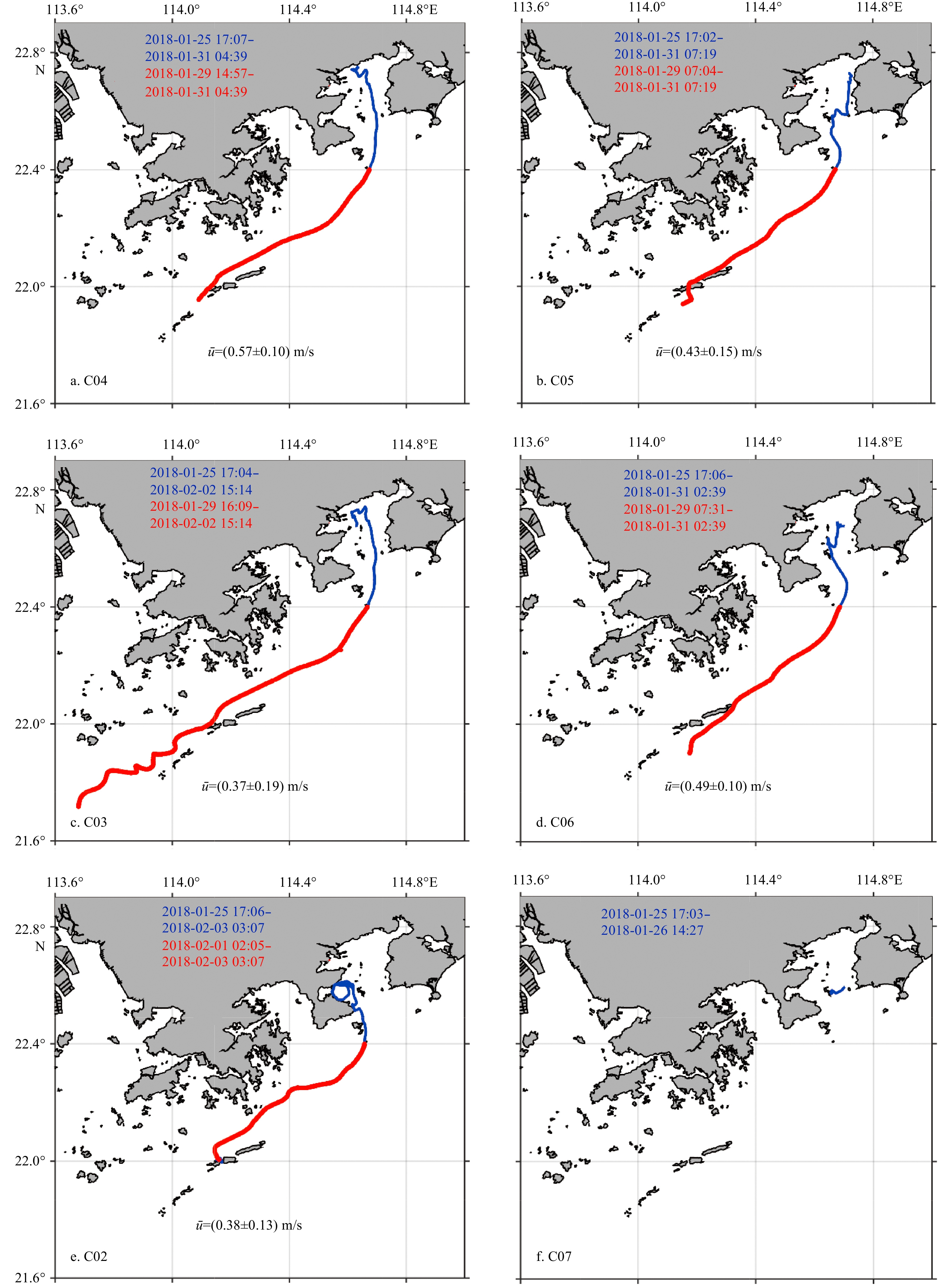
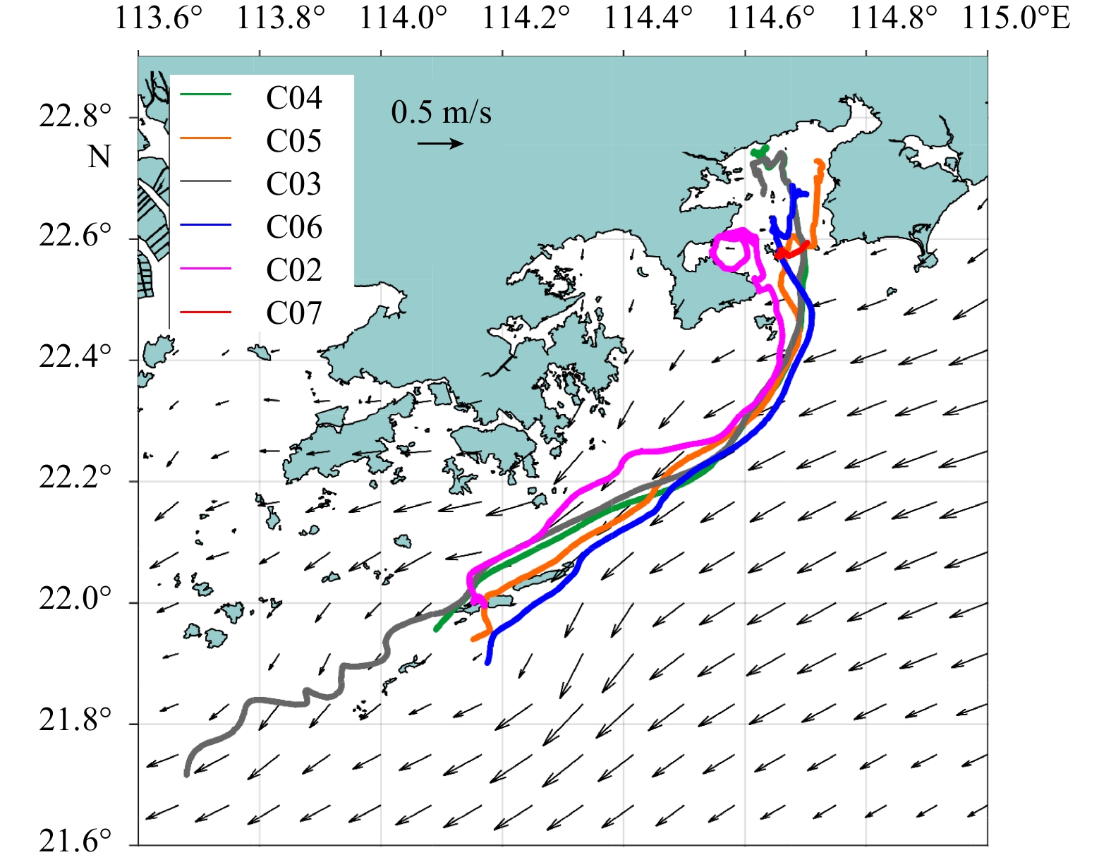
Trajectories of the six drifters deployed in the Daya Bay are shown in Fig. 2 (blue lines). The drifter at C07 moved westward and hit the Dalajia Island about one day after deployment (see Fig. 1c for location); nonetheless, it did not manage to go back to sea and eventually died there when it was out of battery (Fig. 2f). The other five drifters all moved outside the Daya Bay with the ebb tidal flow, and all of them exhibit a southwestward tendency of movement roughly along the Guangdong coast. This is consistent with the mean surface circulation pattern during the survey period (Fig. 3) based on a reanalysis dataset distributed by the Copernicus Marine Environment Monitoring Service (CMEMS; http://marine.copernicus.eu/), and also partially evidenced by historical measurements (Li et al., 2018). The CMEMS reanalysis (identifier: GLOBAL_ANALYSIS_FORECAST_PHY_001_024) has been demonstrated to be able to reproduce the main features of coastal circulation and thermohaline properties in the China seas (e.g., Lin et al., 2017). It is clear that the drifter trajectories closely follow the current vectors along the Guangdong coast (Fig. 3). We also estimate velocities for trajectories outside the Daya Bay (Fig. 2, red lines) to represent the drifter-derived coastal currents. The estimated mean current speed for each drifter ranges between 0.4 and 0.6 m/s (Fig. 3), which is in qualitative agreement with the CMEMS reanalysis although the drifter-derived velocity magnitude is slightly larger than the daily averaged CMEMS velocities.
Figure
2.
Trajectories of drifters deployed in the Daya Bay in January 2018. Blue lines denote the raw trajectories after deployment with the start and end times labeled; red lines denote trajectories along the Guangdong coast within which range the magnitudes of averaged velocity and its standard deviation are shown in black texts.
Figure
3.
Mean surface circulation (2018–01–25 to 2018–02–05) in Guangdong coastal area based on the CMEMS reanalysis data (black vectors) during the survey period. The trajectories of six drifters deployed in the Daya Bay are superimposed.
Although trajectories shown in Fig. 2 only cover a time span of about one week, it is necessary to note that such drifters typically have a lifespan of approximately one month as mentioned in Section 2. The reason for the missing drifter trajectories is due to the loss of mobile phone network signal. After a certain period of loss of communication at offshore areas, some drifters could transmit their real-time data again when re-approaching nearshore regions. We have found such reconnected trajectories near the Hainan Island (figures not shown).
4.
Discussion on wind effects
One of the most important considering in the design of the drifter is to avoid the wind effects on its movement. In order to verify whether drifter trajectory mostly follows the surface ocean current or is obviously affected by wind, we separately compare the direction of drifter trajectories with ocean current and wind directions.
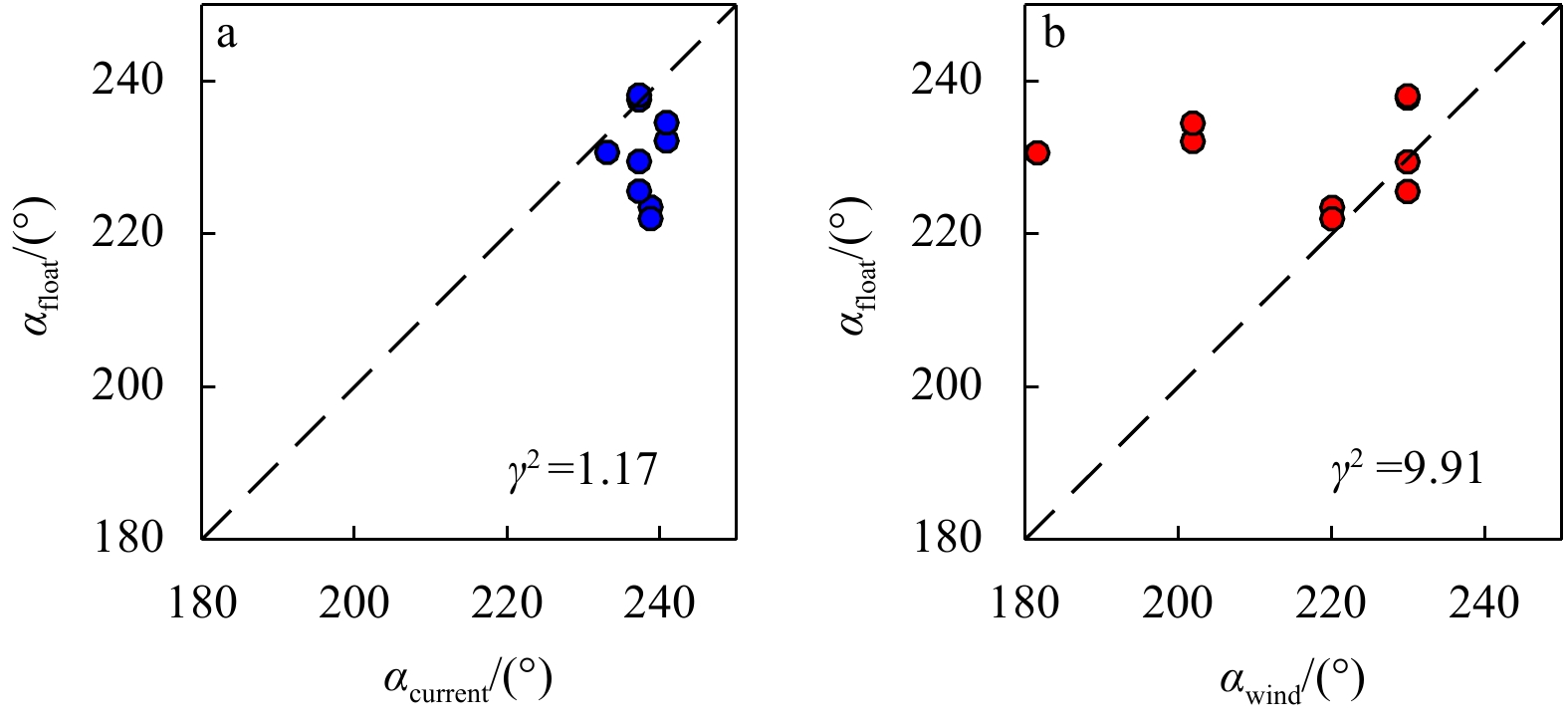
The majority of available drifter trajectories outside Daya Bay are concentrated in January 29–Febuary 1, 2018 (Fig. 4). The current and wind directions are almost aligned in January 29–30 (i.e., southwestward), and the drifter trajectories closely follow them, as expected. In the latter two days, wind directions deflect more southward while the current directions almost stay unchanged. Overall, velocity direction derived from available drifter trajectories (αfloat) in these two days is closer to the current direction (αcurrent) instead of the wind direction (αwind).
Figure
4.
Daily averaged surface ocean currents from CMEMS reanalysis (blue arrows) and 10-m winds from ASCAT (red arrows), superimposed with drifter trajectories (magenta curves) on the same date (shown in black bold texts in each panel).
To be more precise, the agreement is estimated by a quantitative parameter γ2, defined as the variance of αfloat–αcurrent or αfloat–αwind divided by the variance of αFloat (Thompson and Sheng, 1997). γ2 is calculated for αfloat vs αcurrent and αfloat vs αwind, respectively, using daily averaged velocities from all four days and all drifters. Smaller γ2 means smaller discrepancies. It is clear that αfloat has a closer agreement with αcurrent than with αwind (Fig. 5), confirming that the movements of drifters largely follow the surface currents and the wind effects are not significant. We note that all the angle values obtained from daily velocities range between 180° and 250°, so calculating mean values of angle does not encounter the discontinuity problem at 0° and 360°.
Figure
5.
Mean current directions derived from drifters compared with CMEMS-derived current directions (a) and wind directions (b).
Trajectories of six GPS-based SUCE V1.0 drifters deployed in the Daya Bay are examined as an example to test the performance of the self-developed, simple and cheap drifters in capturing the coastal currents. The trajectories and the drifter-derived velocities along the Guangdong coast suggest that such drifters are generally capable of capturing the characteristics of surface coastal currents. They may also serve as an important tool for measuring the surface current system or mesoscale eddy in the South China Sea (e.g., Li et al., 2018; Wei et al., 2019; Zheng et al., 2019).
Acknowledgements
We appreciated comments from two reviewers which improved an early version of the manuscript. All the cruise participants are appreciated.
Austin J, Atkinson S. 2004. The design and testing of small, low-cost GPS-tracked surface drifters. Estuaries, 27(6): 1026–1029. doi: 10.1007/BF02803428
[2]
Johnson D, Stocker R, Head R, et al. 2003. A compact, low-cost GPS drifter for use in the oceanic nearshore zone, lakes, and estuaries. Journal of Atmospheric and Oceanic Technology, 20(2): 1880–1884
[3]
Li Li, Guo Xiaogang, Wu Risheng. 2018. The winter western boundary current of the South China Sea: physical structure and volume transport in December 1998. Acta Oceanologica Sinica, 37(3): 1–7. doi: 10.1007/s13131-018-1195-3
[4]
Lin Hongyang, Hu Jianyu, Liu Zhiyu, et al. 2017. A peculiar lens-shaped structure observed in the South China Sea. Scientific Reports, 7: 478. doi: 10.1038/s41598-017-00593-y
[5]
Mullarney J C, Henderson S M. 2013. A novel drifter designed for use with a mounted Acoustic Doppler Current Profiler in shallow environments. Limnology and Oceanography: Methods, 11(8): 438–449. doi: 10.4319/lom.2013.11.438
[6]
Nasello C, Armenio V. 2016. A new small drifter for shallow water basins: Application to the study of surface currents in the Muggia Bay (Italy). Journal of Sensors, 2016: 6589636. doi: 10.1155/2016/6589636
[7]
Niiler P P, Maximenko N A, McWilliams J C. 2003. Dynamically balanced absolute sea level of the global ocean derived from near-surface velocity observations. Geophysical Research Letters, 30(22): 2164. doi: 10.1029/2003GL018628
[8]
Perez J C, Bonner J, Kelly F J, et al. 2003. Development of a cheap, GPS-based, radio-tracked, surface drifter for closed shallow-water bays. In: Proceedings of the IEEE/OES Seventh Working Conference on Current Measurement Technology. San Diego: IEEE, 66–69, doi: 10.1109/CCM.2003.1194285
[9]
Thompson K R, Sheng J Y. 1997. Subtidal circulation on the Scotian Shelf: assessing the hindcast skill of a linear, barotropic model. Journal of Geophysical Research: Oceans, 102(C11): 24987–25003. doi: 10.1029/97JC00368
[10]
Wei Zexun, Li Shujiang, Susanto R D, et al. 2019. An overview of 10-year observation of the South China Sea branch of the Pacific to Indian Ocean throughflow at the Karimata Strait. Acta Oceanologica Sinica, 38(4): 1–11. doi: 10.1007/s13131-019-1410-x
[11]
Zheng Quanan, Ho C R, Xie Lingling, et al. 2019. A case study of a Kuroshio main path cut-off event and impacts on the South China Sea in fall-winter 2013-2014. Acta Oceanologica Sinica, 38(4): 12–19. doi: 10.1007/s13131-019-1411-9
Jintao Gu, Yu Zhang, Yi Sui, et al. Lagrangian study of floating debris transport around the Pearl River Estuary in summer. Marine Pollution Bulletin, 2025, 211: 117494. doi:10.1016/j.marpolbul.2024.117494
2.
Jintao Gu, Yu Zhang, Pengfei Tuo, et al. Surface floating objects moving from the Pearl River Estuary to Hainan Island: An observational and model study. Journal of Marine Systems, 2024, 241: 103917. doi:10.1016/j.jmarsys.2023.103917
3.
Liudi Zhu, Tingwei Cui, A Runa, et al. Robust remote sensing retrieval of key eutrophication indicators in coastal waters based on explainable machine learning. ISPRS Journal of Photogrammetry and Remote Sensing, 2024, 211: 262. doi:10.1016/j.isprsjprs.2024.04.007
4.
Igor M. Belkin, Shang-Shang Lou, Yi-Tao Zang, et al. The China Coastal Front from Himawari-8 AHI SST Data—Part 2: South China Sea. Remote Sensing, 2024, 16(18): 3415. doi:10.3390/rs16183415
5.
Longqi Yang, Zhenyu Sun, Zhiyuan Hu, et al. Surface Currents Along the Coast of the Chinese Mainland Observed by Coastal Drifters During April‐May 2019. Marine Technology Society Journal, 2023, 57(1): 156. doi:10.4031/MTSJ.57.1.16
6.
Zifeng Hu, Huadong Li, Dongxiao Wang. Characterizing Tidal Currents and Guangdong Coastal Current Over the Northern South China Sea Shelf Using Himawari‐8 Geostationary Satellite Observations. Earth and Space Science, 2023, 10(9) doi:10.1029/2023EA003047
7.
Longqi Yang, Zhida Huang, Zhenyu Sun, et al. Surface Currents Along the Coast of the Chinese Mainland Observed by Coastal Drifters in Autumn and Winter. Marine Technology Society Journal, 2021, 55(5): 161. doi:10.4031/MTSJ.55.5.7
8.
Yang Gao, Yongxiang Huang, Hongyang Lin, et al. Surface currents measured by GPS drifters in Daya Bay and along the eastern Guangdong coast. Frontiers of Earth Science, 2020, 14(2): 376. doi:10.1007/s11707-019-0776-6
Figure 1. Photo of the self-designed drifter with the main components and sizes labeled (a), Photo of an example drifter deployed on the sea (b), and map of the Daya Bay with the drifter deploying stations labeled (magenta dots) (c). The Dalajia Island is also marked.
Figure 2. Trajectories of drifters deployed in the Daya Bay in January 2018. Blue lines denote the raw trajectories after deployment with the start and end times labeled; red lines denote trajectories along the Guangdong coast within which range the magnitudes of averaged velocity and its standard deviation are shown in black texts.
Figure 3. Mean surface circulation (2018–01–25 to 2018–02–05) in Guangdong coastal area based on the CMEMS reanalysis data (black vectors) during the survey period. The trajectories of six drifters deployed in the Daya Bay are superimposed.
Figure 4. Daily averaged surface ocean currents from CMEMS reanalysis (blue arrows) and 10-m winds from ASCAT (red arrows), superimposed with drifter trajectories (magenta curves) on the same date (shown in black bold texts in each panel).
Figure 5. Mean current directions derived from drifters compared with CMEMS-derived current directions (a) and wind directions (b).


 DownLoad: