Lihua Wang, Benwei Shi, Yunxuan Zhou, Hui Sheng, Yanghua Gao, Li Fan, Ziheng Yang. Radial velocity of ocean surface current estimated from SAR Doppler frequency measurements—a case study of Kuroshio in the East China Sea[J]. Acta Oceanologica Sinica, 2021, 40(12): 135-147. doi: 10.1007/s13131-021-1883-2
Citation:
Lihua Wang, Benwei Shi, Yunxuan Zhou, Hui Sheng, Yanghua Gao, Li Fan, Ziheng Yang. Radial velocity of ocean surface current estimated from SAR Doppler frequency measurements—a case study of Kuroshio in the East China Sea[J]. Acta Oceanologica Sinica, 2021, 40(12): 135-147. doi: 10.1007/s13131-021-1883-2
Lihua Wang, Benwei Shi, Yunxuan Zhou, Hui Sheng, Yanghua Gao, Li Fan, Ziheng Yang. Radial velocity of ocean surface current estimated from SAR Doppler frequency measurements—a case study of Kuroshio in the East China Sea[J]. Acta Oceanologica Sinica, 2021, 40(12): 135-147. doi: 10.1007/s13131-021-1883-2
Citation:
Lihua Wang, Benwei Shi, Yunxuan Zhou, Hui Sheng, Yanghua Gao, Li Fan, Ziheng Yang. Radial velocity of ocean surface current estimated from SAR Doppler frequency measurements—a case study of Kuroshio in the East China Sea[J]. Acta Oceanologica Sinica, 2021, 40(12): 135-147. doi: 10.1007/s13131-021-1883-2
Department of Geography and Spatial Information Techniques/Center for Land and Marine Spatial Utilization and Governance Research, Ningbo University, Ningbo 315211, China
2.
State Key Laboratory of Estuarine and Coastal Research, East China Normal University, Shanghai 200062, China
3.
Chongqing Institute of Meteorological Sciences, Chongqing 401147, China
4.
College of Resources and Environment, Chengdu University of Information Technology, Chengdu 610225, China
Funds:
The National Natural Science Foundation of China under contract Nos 42176174 and 41706196; the Open Research Fund of the State Key Laboratory of Estuarine and Coastal Research under contract No. SKLECKF202104; the Zhejiang Provincial Natural Science Foundation of China under contract No. LY22D010002; the National Science Foundation for Post-doctoral Scientists of China under contract No. 2020M683258; the Chongqing Technology Innovation and Application Development Special Project under contract No. cstc2020jscx-msxmX0193; the Sichuan Science and Technology Program under contract No. 2018JY0484.
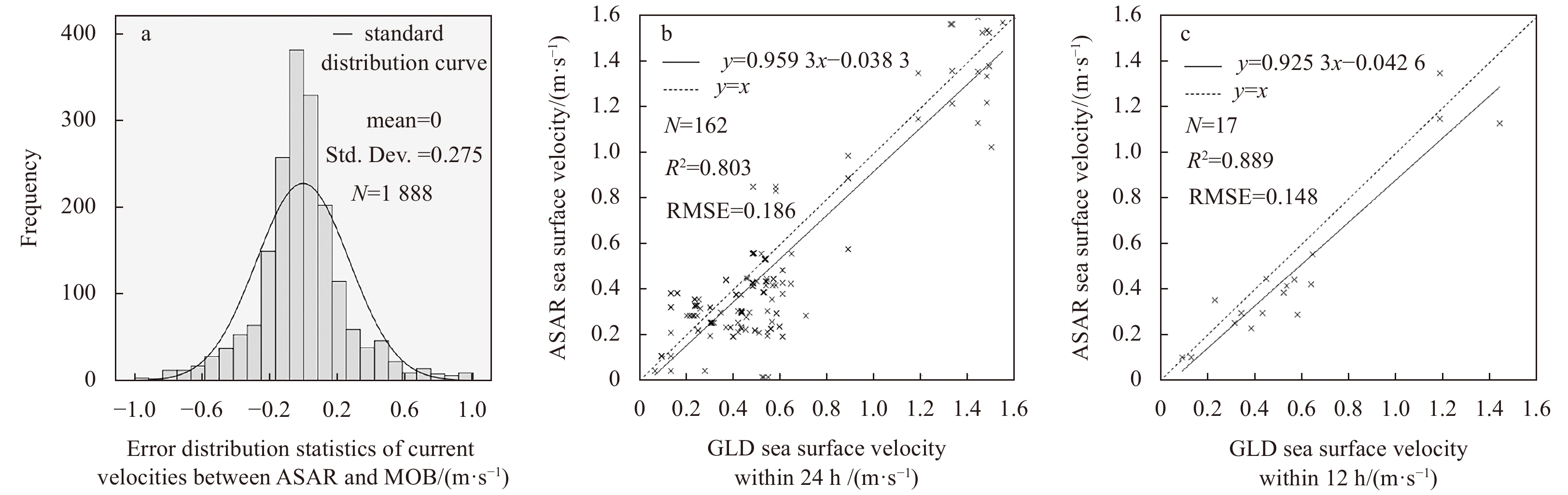
Ocean currents are a key element in ocean processes and in meteorology, affecting material transport and modulating climate change patterns. The Doppler frequency shift information of the synthetic aperture radar (SAR) echo signal can reflect the dynamic characteristics of the sea surface, and has become an essential sea surface dynamic remote sensing parameter. Studies have verified that the instantaneous Doppler frequency shift can realize the SAR detection of the sea surface current. However, the validation of SAR-derived ocean current data and a thorough analysis of the errors associated with them remain lacking. In this study, we derive high spatial resolution flow measurements for the Kuroshio in the East China Sea from SAR data using a theoretical model of shifts in Doppler frequency driven by ocean surface current. Global ocean multi observation (MOB) products and global surface Lagrangian drifter (GLD) data are used to validate the Kuroshio flow retrieved from the SAR data. Results show that the central flow velocity for the Kuroshio derived from the SAR is 0.4–1.5 m/s. The error distribution between SAR ocean currents and MOB products is an approximate standard normal distribution, with the 90% confidence interval concentrated between –0.1 m/s and 0.1 m/s. Comparative analysis of SAR ocean current and GLD products, the correlation coefficient is 0.803, which shows to be significant at a confidence level of 99%. The cross-validation of different ocean current dataset illustrate that the SAR radial current captures the positions and dynamics of the Kuroshio central flow and the Kuroshio Counter Current, and has the capability to monitor current velocity over a wide range of values.
Sponges are an important structure-forming component of the deep-sea benthic fauna, providing biogenic microhabitats to associated organisms and thereby increasing local habitat heterogeneity and supporting high biodiversity, especially when they occur in sponge aggregations (Bell, 2008; Hajdu et al., 2017). Due to the highly complex and exquisite frameworks, the functional significance of euplectellid sponges, well-known for the “Venus flower basket” form and its associated spongicolid shrimps, has been highlighted in enhancing biodiversity and abundance of associated organisms (Kou et al., 2018). Generally, the sponges of family Euplectellidae Gray, 1867 are tubular, cup-like or fungus-like, lophophytose, basiphytose or rhizophytose, and sometimes pedunculate (Shen et al., 2019; Tabachnick, 2002). Megascleres consist of dermal and atrial hexactins (sometimes pentactins or both), choanosomal stauractins, tauactins and diactins (sometimes as well as hexactins and pentactins), and basal anchorate spicules (rarely diactins). Microscleres vary in the outer ends including graphiocomes, floricomes, drepanocomes, and others. There are three subfamilies in this family: Euplectellinae Gray, 1867, Corbitellinae Gray, 1872, and Bolosominae Tabachnick, 2002 (but note that these taxa are likely not monophyletic; see Dohrmann et al., 2017; Dohrmann, 2019; Shen et al., 2019). The subfamily Corbitellinae, in which the typical “Venus flower basket” form is widespread, has 11 genera (4 of them are monotypic) and 39 valid species currently recognized (de Voogd et al., 2021).
The genus Walteria Schulze, 1886 currently consists of two species, W. flemmingii Schulze, 1886 and W. leuckarti Ijima, 1896. They occur in the western Pacific Ocean and eastern Indian Ocean at depths of 370–4 732 m (MacIntosh et al., 2018; Reiswig and Kelly, 2018; Tabachnick, 2002; Tabachnick et al., 2019). The type species W. flemmingii is known from the North Central Pacific Ocean off Hawaii, through the southwest Pacific islands of New Caledonia and New Zealand, extending south to Macquarie Ridge and west to the eastern Indian Ocean of the Perth Canyon in West Australia (MacIntosh et al., 2018; Reiswig and Kelly, 2018; Tabachnick, 2002; Tabachnick et al., 2019). Walteria leuckarti is known from the Sagami Bay, Japan, and Marianas Basin to the southwest Pacific islands around New Zealand (Reiswig and Kelly, 2018). Another indeterminate species of Walteria is known from off Hawaii and New Zealand from depths of 1 446–2 210 m (Reiswig and Kelly, 2018).
By taking W. flemmingii as type species, Schulze (1887) and Tabachnick (2002) described the general morphology and spiculation. Schulze (1887) did not recognize the lateral processes or onychohexaster microscleres, which were supplemented by Tabachnick (2002). However, Tabachnick (2002) made some statements on the existence of prostalia lateralia, large hexactins and pentactins to support the lateral processes, and discasters as some of the disc-bearing microscleres, which were refuted by Reiswig and Kelly (2018) after further collection and examination. Moreover, the existence of primary large stauractins and their importance in generating the rectangular lattice of wall strands were ignored by earlier descriptions, but later underlined by Reiswig and Kelly (2018) in detail. In addition, it was suggested that there were only graphiocomes and floricomes as stellate microscleres (Reiswig and Kelly, 2018). The intraspecific differences between the South Australian specimens having oxyhexasters and New Zealand and Hawaiian specimens having onychohexasters were illustrated (Reiswig and Kelly, 2018). For the valid species, W. leuckarti, which has a unique bottle-brush-like body form, Reiswig and Kelly (2018) indicated that the floricomes are rare and difficult to find; these authors therefore assigned the subspecies W. leuckarti longina Tabachnick, 1988 as a synonymised name so as to avoid subspecies designations within the Hexactinellida. Furthermore, another morphotype, with tubular body, extensive side processes, pointed apex and lattice-like body wall, was suggested to be a new species (Reiswig and Kelly, 2018). This morphotype was previously recorded from off Hawaii and displayed online by the Hawaiian Undersea Research Laboratory (HURL) Archive (http://www.soest.hawaii.edu/HURL/HURLarchive/guide.php). One specimen of dead, eroded framework and lack of loose spiculation (Walteria sp. indet.), coupled with seafloor images presumably identical to it but without collections, from New Zealand was described but not named (Reiswig and Kelly, 2018).
In this study, we describe a new species, the specimens of which were collected by remotely operated vehicle (ROV) at depths of 1 271–1 703 m from the northwestern Pacific seamounts. Local aggregations of this new sponge species and its associated organisms are reported from the Suda Seamount at depths of 1 295–1 320 m. Finally, we present molecular phylogenetic results supporting the placement of the new species in the family Euplectellidae, genus Walteria.
2.
Materials and methods
2.1
Sample and video data collection
Two specimens of Walteria demeterae sp. nov. were collected by ROV from the northwestern Pacific seamounts. The holotype (catalogue number: SIO-POR-244) was collected on September 20, 2018 by ROV Haima from the Weijia Seamount in the northwestern Pacific Ocean at dive ROV12 of cruise DY51/I (12.730 9°N, 156.539 7°E, depth of 1 703 m). The paratype (catalogue number: SIO-POR-099) was collected by ROV Hailong III from the Suda Seamount in the northwestern Pacific Ocean on August 19, 2018 at dive ROV07 of cruise DY48/I (22.010 0°N, 159.377 2°E, depth of 1 271 m). The specimens were preserved in 95% ethanol and deposited in the Sample Repository of Second Institute of Oceanography (SRSIO), Hangzhou, China. A benthic investigation at the Suda Seamount implemented by ROV Hailong III on August 20, 2018 at dive ROV08 of cruise DY48/I (starting point: 22.011 0°N, 159.389 4°E, 1 295 m deep; ending point: 22.012 0°N, 159.391 1°E, 1 307 m deep) recorded a frequent occurrence of a morphotype identical to the new sponge species. Video recordings and still images collected by this investigation, in total 3.0 h, from depths of 1 295–1 320 m, covering 550 m in distance, were examined to describe these local sponge aggregations and the presence of associated macrofauna.
2.2
Spicule and skeleton analysis
Spicules and frameworks were isolated by digesting small pieces of tissue from body wall and lateral processes, which were placed in different centrifuge tubes, in concentrated nitric acid using a metal bath maintained at about 80°C for one day until the tissues were completely dissolved. The spicules and frameworks were then rinsed twice in distilled water and later suspended in alcohol for light microscope (LM) and scanning electron microscope (SEM) observation. Slides for LM were examined with ZEISS Imager A2. Spicules for SEM (TM-1 000 Tabletop Microscope) were pipetted from the solution onto silicon wafers, and skeletons were moved onto silicon wafers, all of which were subsequently coated with platinum. Photomicrographs were obtained by SEM, and measurements were made with the software ZEN pro 2012 1.1.2.0.
2.3
Molecular work
DNA was extracted from small pieces of tissue using a DNeasy Blood&Tissue Kit (Qiagen) according to the manufacturer’s instructions. The DNA quality and concentration were detected with a Nanodrop 2000 and Qubit fluorometer. Then the whole genome was sequenced via the Illumina PE150 strategy on the HiSeqTM X-Ten platform (Illumina, CA, USA) at Zhejiang Tianke High Technology Development Co., Ltd. The total of clean reads was assembled with the SPAdes genome assembler (Bankevich et al., 2012). The nuclear 18S rDNA and 28S rDNA, and mitochondrial 16S rDNA and cytochrome c oxidase subunit I (COI) genes were retrieved from the assembled contigs and used for phylogenetic analysis. The start and end of target sequences were checked by the reported universal PCR primer pairs (Dohrmann et al., 2008; Folmer et al., 1994). The 18S rDNA, 28S rDNA, 16S rDNA, and COI gene sequences are deposited in GenBank with accession numbers of MW652662, MW652660, MW652655, and MW517848, respectively.
2.4
Phylogenetic analysis
The four sequences of 18S rDNA, 28S rDNA, 16S rDNA, and COI plus reference data, were aligned using the ClustalW algorithm with default settings (15/6.66 as gap/gap length penalties) in Geneious prime (Biomatters Ltd., New Zealand). The alignments were performed separately, and then concatenated into one file after manually trimming unalignable regions on both flanks. The phylogenetic tree was inferred with maximum likelihood (ML) analysis using IQ-TREE (Nguyen et al., 2015; Chernomor et al., 2016). The auto-selected best substitution model (-m MFP option) was used in IQ-TREE, with 1 000 bootstrap replicates (command line and input parameters: iqtree -s concatenated_alignments.phy -m MFP -p concatenated_alignments_partition.txt -bb 1 000 -alrt 1 000). The ultrafast bootstrap (UFBoot) was used to assess clade support by adding “-bb 1 000” (Hoang et al., 2018; Minh et al., 2013). An SH-aLRT test (Guindon et al., 2010) was also performed by adding “-alrt 1 000”. The tree was constructed based on the concatenated alignment file of Walteria demeterae sp. nov. and other 31 reference species of hexactinellids by taking three species of the genus Tretopleura as outgroups (detailed information of sequences is shown in Table 1). The ML tree was then visualized and edited in Figtree 1.4.2 (Rambaut, 2006).
Table
1.
GenBank accession numbers of marker genes of the 32 species used in the molecular phylogenetic analysis
Order: family
Species
Voucher number
Accession number
18S rDNA
28S rDNA
16S rDNA
COI gene
Lyssacinosida: Euplectellidae
Walteria demeterae sp. nov. (holotype)
SIO-POR-244
MW652662
MW652660
MW652655
MW517848
Walteria leuckarti
SMF 10522
AM886399
AM886373
AM886337
FR848939
Docosaccus maculatus
GW5429
FM946116
FM946115
FM946105
FR848934
Rhabdopectella tintinnus
HBOI 4-X-88-2-014
AM886402
AM886371
AM886332
FR848941
Regadrella sp.
HBFH 8-VIII-09-2-001
/
FR848916
FR848917
/
Rhizophyta yapensis
SIO-POR-083
MK463603
MK463607
MK458682
MK453399
Acoelocalyx brucei
SMF 10530
AM886401
AM886370
AM886333
FR848938
Malacosaccus coatsi
SMF 10521
AM886400
AM886369
AM886334
FR848937
Euplectella sp. 1
HBOI 19-XI-86-1-001
AM886397
AM886368
AM886335
FR848935
Euplectella sp. 2
HBOI 12-XI-86-1-054
AM886398
AM886367
AM886336
/
Saccocalyx microhexactin
MBM179994
/
/
KM881702
/
Saccocalyx pedunculatus
SMF 12082
MF740862
MF684009
MF683987
/
Hertwigia sp.
USNM 1122181
FM946121
FM946120
FM946104
FR848940
Bolosoma sp.
USNM 1097546
FM946118
FM946117
FM946102
FR848942
Bolosominae n. gen. n. sp.
HURL P4-224-sp7
/
LT627534
LT627520
LT627552
Atlantisella sp.
HBOI 22-X-95-1-7
LT627547
LT627533
LT627519
/
Holascus euonyx
SMF12092
MF740859
/
MF683980
/
Holascus taraxacum
SMF12059
/
MF684005
MF683982
/
Hyalostylus microfloricomus
SMF12085
MF740860
MF684007
MF683984
/
Hyalostylus schulzei
SMF11707
/
/
MF683985
/
Lyssacinosida: Rossellidae
Rossella nuda
SMF 10531
AM886384
AM886355
AM886343
HE580217*
Nodastrella asconemaoida
ZMA POR18484
AM886386
AM886354
AM886344
FR848921
Caulophacus arcticus
SMF 10520
AM886395
AM886360
AM886350
FR819684
Caulophacella tenuis
SMF 10533
AM886392
AM886363
AM886351
FR848927
Caulophacus valdiviae
SMF 10528
AM886394
AM886362
AM886348
FR848929
Caulophacus weddelli
SMF 10527
AM886393
AM886361
AM886349
FR848928
Crateromorpha meyeri
SMF 10525
AM886389
AM886359
AM886347
FR848923
Bathydorus spinosus
SMF 10526
AM886390
AM886358
AM886341
FR848924
Lyssacinosida: Aulocalycidae
Euryplegma auriculare
NIWA 43457
/
LT627535
LT627518
LT627551
Sceptrulophora: Uncinateridae
Tretopleura weijica
SIO-POR-090
/
/
MT176124
MT178277
Tretopleura sp. 1
HURL P4-229-sp10
/
LT627542
LT627529
LT627556
Tretopleura sp. 2
HURL P5-701-sp4
/
LT627543
LT627530
LT627555
Note: The symbol “*” refers that the COI gene of Rossella nuda was from the voucher SMF 11730.
Figure
1.Walteria demeterae sp. nov. specimens. Holotype: in situ images (a1), whole collected specimen including five segments (a2), close-up images of a slightly damaged apex (a3), middle body (a4), and basal part (a5); paratype: in situ image (b1), whole collected specimen including two segments (b2), and close-up image of middle body showing fused skeleton (b3).
Figure
2.Walteria demeterae sp. nov., seafloor images of the same morphotype observed at dive ROV08 of cruise DY48/I from the Suda Seamount in the northwestern Pacific Ocean. a. Living individuals showing different shapes of tubular body with close-up images of small terminal osculum in the pointed apex, circular strands in the inner wall, and lateral processes projecting from the body wall; b. dead individuals showing different degrees of erosion with close-up images of pointed apex and basal part; c. concurrence of both living and dead individuals in one image; d. examples of invertebrates associated with living or dead individuals, including Comatulida, Spongicolidae, Ophioplinthaca defensor, Paguridae, Cirripedia and others (from top to bottom, then from left to right).
Figure
3.Walteria demeteraesp. nov., surfaces of holotype. Dermal surface of body wall with lateral oscula (a1), close-up image of crossing longitudinal and transverse bundles (a2), and SEM of longitudinal bundles (a3); atrial surface of body wall with lateral oscula (b1), close-up image of crossing longitudinal and transverse bundles (b2), and SEM of transverse bundles (b3); lateral processes of dichotomously branching (c1) or simple (c2) outgrowths, the SEM of framework at junction of body wall and lateral process (c3) and its fused diactins (c4); attached stauractins (d1, d2), pentactins (d3, d4) and occasionally hexactins (d5).
Figure
4.Walteria demeterae sp. nov., spicules. a. Choanosomal diactin, whole and enlargements of three types of rays and middle segments; b. choanosomal stauractin, whole and enlargements of axial centre and two types of rays; c. dermal sword hexactin, whole and enlargements of tangential, proximal and two types of distal rays; d. atrial pentactin, whole and enlargements of axial centre, proximal ray, and two types of tangential rays with a smooth or slightly rough tip; e. oxyhexactins, which are sparsely covered by fine spines (located all over the body, e1) or entirely covered by macrospines (restricted to the basal part, e2), whole and enlargements of centres and rays; f. graphiocome, primary centre and terminal ray at same scale, enlargements of primary centre and both the basal part and tip of terminal ray; g. discohexasters in common dense form or rare sparse form (corresponding to “discohexaster 1” and “discohexaster 2” described for W. flemmingii and W. leuckarti by Reiswig and Kelly, 2018), whole and enlargements of terminal ray and disc; h. onychohexaster, whole and enlargements of six types of onychoid tips with 1–5 claws; i. floricome, whole (not intact) and enlargements of terminal ray and tip.
Figure
5.
Maximum-likelihood phylogenetic tree of 32 species from four families of Class Hexactinellida (by taking three species of the genus Tretopleuraas as outgroups), showing the relationships of the species Walteria demeterae sp. nov. and related taxa. The tree was inferred from the concatenated alignments of 18S rDNA, 28S rDNA, 16S rDNA and COI. Numbers at nodes are SH-aLRT/ UFBoot support values (all based on 1 000 replicates).
Material examined. Holotype (Fig. 1a): SIO-POR-244, SRSIO,Haima ROV DY51/I, dive ROV12, collected by Bo Lu, September 20, 2018, at Weijia Seamount in the northwestern Pacific Ocean (12.730 9°N, 156.539 7°E), depth of 1 703 m, stored in 95% ethanol. Paratype (Fig. 1b): SIO-POR-099, SRSIO, Hailong III ROV DY48/I, dive ROV07, collected by Dongsheng Zhang, August 19, 2018, at Suda Seamount in the northwestern Pacific Ocean (22.010 0°N, 159.377 2°E), depth of 1 271 m, stored in 95% ethanol.
Other locations (images only; Fig. 2). Suda Seamount in the northwestern Pacific Ocean: Hailong III ROV DY48/I, dive ROV08, 22.011 0°–22.012 0°N, 159.389 4°–159.391 1°E, depths of 1 295–1 320 m, August 20, 2018.
Description. The new species is presented by a tubular body with lateral oscula and processes (Fig. 1). The holotype has a tubular body with extensive side processes, pointed apex, lattice-like body wall and basiphytous attachment (Fig. 1a). Wall is thin and rigid with numerous oval lateral oscula in irregular arrangement. Distal lateral processes are simple or dichotomously branching outgrowths of the lateral wall. Color of the specimen in ethanol is transparent white.
Five segments are totally 919.8 mm in length and 46.1 mm in maximum diameter (Fig. 1a2). The pointed apex tapers to a very small terminal osculum but is damaged at the top (Fig. 1a3). A large number of lateral processes project about 85 mm from the nodes of the lateral outer surface, forming a crudely hairy aspect (Fig. 1a4). The numerous oval lateral oscula are 15 mm in maximum diameter. Spacing between lateral oscula is nearly adjacent or with maximum edge-to-edge distance of 25 mm. The basal end forms an attachment disc with a smaller diameter than the tubular body attached to hard substrate and supported by lateral struts (Fig. 1a5). The cylindrical body is slightly oblique, the external wall is relatively smooth while the internal wall shows numerous bulging circular strands. The lateral oscula are generally separated by these strands.
The paratype was collected as a long dead, eroded framework with broken lateral processes and lack of loose spiculation (Fig. 1b). Two segments of tubular body and pointed apex are totally 674.4 mm in length and 71.2 mm in maximum diameter (Fig. 1b2). The numerous oval lateral oscula are 20 mm in maximum diameter. Spacing between lateral oscula is nearly adjacent or with maximum edge-to-edge distance of 25 mm. The lateral processes were broken to project at most 48 mm. The pointed apex bends and tapers to a very small terminal osculum but is damaged at the top. Longitudinal, circular and oblique strands can be observed within the framework (Fig. 1b3). Color in ethanol is light brown.
Relevant seafloor images clearly present the unique morphotype characterized by a lattice-work, tubular body with numerous lateral processes, forming a crudely hairy aspect for living individuals or a hispid body wall in different densities and lengths for dead individuals (Fig. 2). The tubular body varies in degree of bending and the pointed apex tapers sharply or tenderly.
Skeleton. The principle skeleton mainly consists of fused diactins with sparsely attached small stauractins, pentactins and sometimes hexactins (Fig. 3). The main skeletal framework of the body wall is a dominant network of crossing longitudinal, transverse and oblique bundles of thick and smooth diactins closely fused by synapticula and therein an irregular framework formed by ray-to-ray fusion of relatively thin diactins at different angles in a plane (Figs 3a and b). Longitudinal bundles are always dermal (Fig. 3a3); transverse (circular) bundles are always the most atrial (Fig. 3b3); oblique bundles and the irregular framework are situated between the longitudinal and transverse bundles. Transverse bundles are strongest and apparent to the naked eye in the collected specimen; longitudinal and oblique bundles are also strong, and the former are much thicker near the base. The framework of lateral processes consists of several parallel diactins fused by synapticula (Fig. 3c). The principle skeleton of the body wall, especially close to the spicule bundles, is sparsely covered by attached small and smooth stauractins, pentactins and occasionally hexactins (Fig. 3d).
The ectosomal skeleton of the dermal surface is composed of a layer of mainly sword-shaped hexactins as dermalia with the short distal ray pointing outwards, covering the outer surface of the main body wall and all surfaces of the lateral processes. The inner surface of the body wall is covered by a layer of pentactins as atrialia, with the long proximal rays extending into the wall. Microscleres are dispersed among the proximal rays of dermalia and atrialia.
Spicules. Megascleres of the body are choanosomal diactins and stauractins, dermal hexactins, and atrial pentactins (Figs 4a-d; Table 2).
Choanosomal diactins (Fig. 4a) vary widely in size with 451.0–(1 071.4)–4 300.0 µm in length (some can be longer) and 8.0–(14.0)–27.5 µm in diameter (Table 2). They are straight or gently curved, subterminally rough or rarely smooth, with a generally inconspicuous or evident central swelling, rounded or conically pointed terminal ends, sometimes slightly inflated near the tips.
Choanosomal stauractins (Fig. 4b) are rarely observed and have lateral rays with rounded or blunt-pointed terminal ends which are rough and slightly inflated near the tips. The lateral rays of stauractins are generally unequal with the long ray 168.5–(265.9)–738.9 µm in length and the short ray 107.5–(157.6)–211.3 µm in length; the ray width is 8.8–(14.2)–18.5 µm (Table 2). There is a nearly undetectable swelling or sometimes a thin and very short fifth ray in the axial cross.
Dermalia (Fig. 4c) of the body wall and lateral processes are similar sword hexactins with proclined spines covering the terminal end of each ray. The distal ray is inflated lanceolate, sometimes oval or occasionally uninflated (or slightly inflated), 88.9–(172.0)–275.0 µm long in the lateral processes, longer than that in the body wall with 49.2–(136.2)–215.0 µm in length; tangential rays have rounded and often slightly inflated terminal ends, with a mean length of about 122 µm both in the body wall and lateral processes but varying more widely in size in the body wall than in the lateral processes; the proximal ray is 1.5–(4.2)–9.4 times longer than the tangential rays with conically pointed tips, which is 243.3–(506.6)–882.0 µm long and 11.3–(14.5)–17.3 µm thick in the lateralas processes, larger than that in the body wall with 114.0–(431.9)–686.7 µm in length and 6.4–(13.6)–18.7 µm in width (Table 2). Dermal sword hexactins are more common in the lateral processes but more variable in the body wall.
Atrialia are regular smooth pentactins (Fig. 4d), mainly present within the body wall, with a small or rarely spherical swelling; tangential rays are 111.5–(158.0)–225.0 µm long with tips smooth or slightly rough, rounded or bluntly pointed, rarely inflated; the proximal ray varies in length of 83.3–(310.2)–654.0 µm with slightly rough and blunt-pointed tips (Table 2).
Microscleres are common oxyhexactins and graphiocomes, a number of discohexasters, some onychohexasters, and rare floricomes (Figs 4e-i; Table 2).
Oxyhexactins (Fig. 4e) in the whole body wall and lateral processes are sparsely covered by fine spines over the entire surface or rarely smooth, both similar in size and shape with rougher and parabolic terminal ends (smooth-rough oxyhexactins; Fig. 4e1). In addition, there is another kind of oxyhexactin entirely covered by macrospines, 3.0–(7.1)–12.0 µm in maximum length, with sharply pointed tips (macrospined oxyhexactins; Fig. 4e2; Table 2), which are restricted to the basal part. Rays of the former are 115.0–(180.3)–265.0 µm long and 3.9–(8.0)–12.4 µm thick, larger than the macrospined ones with 71.5–(117.7)–195.3 µm in length and 2.3–(3.0)–4.0 µm in width (Table 2).
Graphiocomes (Fig. 4f) are typical for Euplectellidae with 22.7–(25.6)–29.7 µm in centre diameter; the primary rays are 6.3–(7.5)–10.0 µm long, ornamented with short smooth hemispheric knobs or rarely smooth; terminal rays (raphides) are very thin and 100.0–(158.9)–179.0 µm long, bearing sparse recurved spines (Table 2); each primary ray supports on its distal swelling about 60 bases of raphides.
Discohexasters (Fig. 4g) are spherical, 77.5–(88.9)–110.0 µm in diameter, with very short smooth primary rays 3.5–(5.8)–9.0 µm in length and rough straight terminal rays 30.0–(35.7)–46.1 µm in length (Table 2); they occur in either the more common dense form with more than 12 terminal rays per primary ray or rare sparse form with about 6 terminal rays on each primary ray; marginal teeth on terminal discs number 11–13.
Onychohexasters (Fig. 4h) are 70.0–(83.0)–100.0 µm in diameter, a little smaller than discohexasters; the primary rays are 2.5–(4.1)–6.7 µm long, with a bulge extending beyond the origins of the terminal rays; the terminal rays are 30.0–(37.0)–45.2 µm in length, covered by either fine or large recurved spines (Table 2); onychoid tips in individual spicules are often distinct with 1–5 claws.
Floricomes (Fig. 4i) were only observed thrice in the body wall, with a diameter of 84.7–(122.1)–184.0 µm; the primary rays are smooth and 3.8–(5.8)–8.3 µm long; terminal rays are 33.3–(53.5)–83.3 µm long and at about nine per primary ray with five terminal claws, of which the outer surfaces are sparsely covered by fine spines (Table 2).
Etymology. The new species name demeterae refers to the goddess of fertility and harvest in Greek mythology named Demeter, referring to the abundant organisms often associating with the new species as well as its attractive appearance in situ.
Remarks. The new species described here is tubular, basiphytous but not pedunculate, bearing choanosomal diactins and stauractins, dermal hexactins, atrial pentactins and various microscleres, and is therefore clearly attributed to the subfamily Corbitellinae of family Euplectellidae (Tabachnick, 2002). Its extensive lateral processes, numerous oval lateral oscula which are irregularly situated in the body wall, the presence of microscleres with oxyoidal (microhexactins and graphiocomes), discoidal and onychoidal outer ends, and the absence of anchorate discohexasters, suggest it belongs to the genus Walteria (Tabachnick, 2002), which is also confirmed by our molecular phylogenetic study (see Section 3.3 below).
The new species shares the form of a hollow body with lateral oscula and processes with the two valid species and their loose spiculation is highly similar in composition and form, but the new species is significantly differentiated in the framework of the body wall. Walteria flemmingii has a net-like, barrel-shaped body with a reticulate wall consisting of a sieve-like network of thin strands; the central elements of strands are primarily large stauractins and diactins generally fused by synapticula into a rigid network. The new species has a tubular body with thin wall and pointed apex similar to that of W. flemmingii but is distinguished by its principle skeleton consisting mostly of diactins (without substantial contribution of stauractins). For the loose spiculation, there are choanosomal tauactins, floricomes in variable abundance, and sometimes oxyhexasters occurring in W. flemmingii, but none of choanosomal tauactins or oxyhexasters was observed in the new species and only three floricomes were observed in the holotype.
Walteria leuckarti has a bottle-brush-like body with a slender, tubular main stem composed of diactins soldered together at contact points or connected by synapticula to form a thick stem wall with oval lateral oscula. The new species has primary spicules of the body wall framework as diactins and the oval lateral oscula similar to that of W. leuckarti but is distinguished by its much larger diameters of both cylindrical body and lateral oscula while much smaller thickness of the body wall. For the loose spiculation, there are choanosomal tauactins and sometimes oxyhexasters occurring in W. leuckarti, but none of these two types of spicules was observed in the new species.
In addition, the dead and eroded framework (Walteria sp. indet.) described by Reiswig and Kelly (2018) was a choanosomal skeleton consisting of a framework of fused diactins, suggesting a tubular body with oval lateral oscula but no evidence of lateral processes. Its lateral oscula are much more pronounced than in the paratype of the new species, which was also collected as an eroded framework; neither transverse or circular bundles are obvious, and nor do spicules attach to the longitudinal bundles, suggesting it is different from the new species described here. Furthermore, the related records of seafloor images from off Hawaii and New Zealand are almost identical to the appearance of the new specimens and in situ images from this study and can be allocated to the same morphotype rather than the eroded framework (Walteria sp. indet.) described by Reiswig and Kelly (2018). But whether they are the same species retains to be determined until a related living specimen from off Hawaii or New Zealand is collected.
3.2
Ecology of the new sponge species
Walteria demeterae sp. nov. is distributed in the northwestern Pacific seamounts (depths of 1 271–1 703 m; specimens and images). The bottom disc of the tubular body is attached to hard substrate. Local aggregations of Walteria demeterae sp. nov. were observed on the Suda Seamount in the northwestern Pacific Ocean at depths of 1 295–1 320 m (Fig. 2). At least 56 individuals characterized by the unique morphotype of the new sponge species were counted, representing 90% of the total individuals of sponges recorded in the track covering 550 m in distance. There were 33 individuals alive and others dead in different degrees of erosion.
Numerous ophiuroids (such as Ophioplinthaca defensor, Ophioleila elegans), crinoids (Comatulida), crustaceans (such as Spongicolidae, Paguridae, Cirripedia) and other taxa were often observed associating with both living and dead individuals of Walteria demeterae sp. nov. (Fig. 2). Echinoderms, in particular crinoids and ophiuroids, were often found in high abundances attached to the sponges, with ophiuroids on or inside the canals and several crinoids often on the upper portion (Beazley et al., 2013; Na et al., 2021). Spongicolid shrimps, which often take euplectellid sponges as their hosts (Kou et al., 2018; Xu et al., 2017), were observed on or inside the canals. Other crustaceans, such as hermit crabs and barnacles, were observed to prefer dead individuals of Walteria demeterae sp. nov. over living ones.
3.3
Molecular phylogenetic analysis of the new sponge species
The length of the 18S rDNA, 28S rDNA,16S rDNA, and COI gene fragments was confirmed by respective primers sequence (Dohrmann et al., 2008; Folmer et al., 1994), and the PCR primers of the four target fragments could be located in the correct position of the marker genes. The data set of 18S rDNA, 28S rDNA, 16S rDNA partial sequence and COI complete sequence of Walteria demeterae sp. nov. (holotype; catalogue number: SIO-POR-244) contained 1 955 bp, 1 225 bp, 495 bp and 709 bp, respectively. The phylogeny confirms that the new species is closely related to W. leuckarti, supporting its systematic position within the family Euplectellidae, genus Walteria (Fig. 5).
4.
Conclusions
According to both morphological and molecular assessment, the hexactinellid specimens described here clearly belong to a species new to science and are attributed to the genus Walteria (family Euplectellidae). This new species, Walteria demeterae sp. nov., shows a unique morphotype characterized by a lattice-work, tubular body with numerous lateral processes. Its structural complexity plays a key role in providing biogenic microhabitats and accordingly increasing biodiversity and abundance of associated organisms in the deep sea. Due to the rare specimens but relatively common records in seafloor images of the morphotype of this new sponge species, new materials should be collected and analyzed to examine intraspecific differences.
The method we used here for searching marker genes in genome-level datasets of marine macrobenthos has proven effective when applied to sponges. It can also provide basic information to design or edit primers when amplification of the gene fragments of relevant species is needed.
Acknowledgements
We thank all the scientists and crew on the R/V Haiyang 6 and Dayang Yihao and the ROV Haima and Hailong III teams, for their dedicated research work and collection of deep-sea specimens. We thank Dohrmann Martin for the constructive suggestions.
Ambe D, Imawaki S, Uchida H, et al. 2004. Estimating the Kuroshio axis south of Japan using combination of satellite altimetry and drifting buoys. Journal of Oceanography, 60(2): 375–382. doi: 10.1023/B:JOCE.0000038343.31468.fe
[2]
Chapron B, Collard F, Ardhuin F. 2005. Direct measurements of ocean surface velocity from space: Interpretation and validation. Journal of Geophysical Research: Oceans, 110(C7): C07008
[3]
Chapron B, Collard F, Kerbaol V. 2004. Satellite synthetic aperture radar sea surface Doppler measurements. In: Proceedings of the 2nd Workshop on Coastal and Marine Applications of SAR. Svalbard, Norway: ESA Special Publication
[4]
Deng Lijing, Wei Hao, Wang Jianing. 2015. Vertical distribution of the Kuroshio velocity in the Pollution Nagasaki section and its formative mechanism. Marine Science Bulletin, 17(1): 26–39
[5]
Essen H H, Gurgel K W, Schlick T. 2000. On the accuracy of current measurements by means of HF radar. IEEE Journal of Oceanic Engineering, 25(4): 472–480. doi: 10.1109/48.895354
Goldstein R M, Zebker H A, Barnett T P. 1989. Remote sensing of ocean currents. Science, 246(4935): 1282–1285. doi: 10.1126/science.246.4935.1282
[8]
Graber H C, Thompson D R, Carande R E. 1996. Ocean surface features and currents measured with synthetic aperture radar interferometry and HF radar. Journal of Geophysical Research: Oceans, 101(C11): 25813–25832. doi: 10.1029/96JC02241
[9]
Guan Bingxian. 1979. Some results from the study of the variation of the Kuroshio in the East China Sea. Oceanologia et Limnologia Sinica (in Chinese), 10(4): 297–306
[10]
Guo Xinyu, Miyazawa Y, Yamagata T. 2006. The Kuroshio onshore intrusion along the shelf break of the East China Sea: The origin of the Tsushima Warm Current. Journal of Physical Oceanography, 36(12): 2205–2231. doi: 10.1175/JPO2976.1
[11]
Han Shuzong, Yang Hua, Xue Wenhu, et al. 2017. The study of single station inverting the sea surface current by HF ground wave radar based on adjoint assimilation technology. Journal of Ocean University of China, 16(3): 383–388. doi: 10.1007/s11802-017-3189-8
[12]
Hansen M W, Collard F, Dagestad K F, et al. 2011a. Retrieval of sea surface range velocities from Envisat ASAR Doppler centroid measurements. IEEE Transactions on Geoscience and Remote Sensing, 49(10): 3582–3592. doi: 10.1109/TGRS.2011.2153864
[13]
Hansen M W, Johannessen J A, Dagestad K F, et al. 2011b. Monitoring the surface inflow of Atlantic Water to the Norwegian Sea using Envisat ASAR. Journal of Geophysical Research: Oceans, 116(C12): C12008. doi: 10.1029/2011JC007375
[14]
He Yijun. 2000. Ocean wave imaging mechanism by imaging radar. Science in China Series D: Earth Sciences, 43(6): 587–595. doi: 10.1007/BF02879502
[15]
He Yijun, Yang Xiaobo, Yi Na, et al. 2020. Progress in sea surface current retrieval from spaceborne SAR measurements. Journal of Nanjing University of Information Science and Technology (in Chinese), 12(2): 181–190
[16]
Jia Yongjun, Zhang Youguang, Lin Mingsen. 2013. The numerical simulation of the Kuroshio frontal eddies in the East China Sea using a hybrid coordinate ocean mode. Acta Oceanologica Sinica, 32(5): 31–41. doi: 10.1007/s13131-013-0311-7
[17]
Johannessen J A, Chapron B, Collard F, et al. 2008. Direct ocean surface velocity measurements from space: Improved quantitative interpretation of Envisat ASAR observations. Geophysical Research Letters, 35(22): L22608. doi: 10.1029/2008GL035709
[18]
Johannessen J A, Shuchman R A, Digranes G, et al. 1996. Coastal ocean fronts and eddies imaged with ERS 1 synthetic aperture radar. Journal of Geophysical Research: Oceans, 101(C3): 6651–6667. doi: 10.1029/95JC02962
[19]
Klemas V. 2012. Remote sensing of coastal and ocean currents: An overview. Journal of Coastal Research, 28(3): 576–586. doi: 10.2112/JCOASTRES-D-11-00197.1
[20]
Lehner S, Hoja D, Schulz-Stellenfleth J. 2002. Marine parameters from synergy of optical and radar satellite data. Advances in Space Research, 29(1): 23–32. doi: 10.1016/S0273-1177(01)00623-8
[21]
Li Shuiqing, Liu Baochang, Shen Hui, et al. 2020. Wind wave effects on remote sensing of sea surface currents from SAR. Journal of Geophysical Research: Oceans, 125(7): e2020JC016166
[22]
Lin Hui, Xu Qing, Zheng Quan’an. 2008. An overview on SAR measurements of sea surface wind. Progress in Natural Science, 18(8): 913–919. doi: 10.1016/j.pnsc.2008.03.008
[23]
Liu Baochang, He Yijun, Li Yongkang, et al. 2019. A new azimuth ambiguity suppression algorithm for surface current measurement in coastal waters and rivers with along-track InSAR. IEEE Transactions on Geoscience and Remote Sensing, 57(6): 3148–3165. doi: 10.1109/TGRS.2018.2881958
[24]
Ma Chao, Wu Dexing, Lin Xiaopei. 2009. Variability of surface velocity in the Kuroshio Current and adjacent waters derived from Argos drifter buoys and satellite altimeter data. Chinese Journal of Oceanology and Limnology, 27(2): 208–217. doi: 10.1007/s00343-009-9260-6
[25]
Moiseev A, Johnsen H, Hansen M W, et al. 2020. Evaluation of radial ocean surface currents derived from Sentinel-1 IW Doppler shift using coastal radar and Lagrangian surface drifter observations. Journal of Geophysical Research: Oceans, 125(4): e2019JC015743
[26]
Mouche A A, Collard F, Chapron B, et al. 2012. On the use of Doppler shift for sea surface wind retrieval from SAR. IEEE Transactions on Geoscience and Remote Sensing, 50(7): 2901–2909. doi: 10.1109/TGRS.2011.2174998
[27]
Qiu Bo, Chen Shuiming, Klein P, et al. 2020. Reconstructing upper-ocean vertical velocity field from sea surface height in the presence of unbalanced motion. Journal of Physical Oceanography, 50(1): 55–79. doi: 10.1175/JPO-D-19-0172.1
[28]
Qiu Bo, Lukas R. 1996. Seasonal and interannual variability of the North Equatorial Current, the Mindanao Current, and the Kuroshio along the Pacific western boundary. Journal of Geophysical Research: Oceans, 101(C5): 12315–12330. doi: 10.1029/95JC03204
[29]
Quilfen Y, Chapron B. 2019. Ocean surface wave-current signatures from satellite altimeter measurements. Geophysical Research Letters, 46(1): 253–261. doi: 10.1029/2018GL081029
[30]
Rio M H, Mulet S, Picot N. 2014. Beyond GOCE for the ocean circulation estimate: Synergetic use of altimetry, gravimetry, and in situ data provides new insight into geostrophic and Ekman currents. Geophysical Research Letters, 41(24): 8918–8925. doi: 10.1002/2014GL061773
[31]
Romeiser R. 2005. Current measurements by airborne along-track InSAR: Measuring technique and experimental results. IEEE Journal of Oceanic Engineering, 30(3): 552–569. doi: 10.1109/JOE.2005.857508
[32]
Romeiser R, Suchandt S, Runge H, et al. 2010. First analysis of TerraSAR-X along-track InSAR-Derived current fields. IEEE Transactions on Geoscience and Remote Sensing, 48(2): 820–829. doi: 10.1109/TGRS.2009.2030885
[33]
Romeiser R, Thompson D R. 2000. Numerical study on the along-track interferometric radar imaging mechanism of oceanic surface currents. IEEE Transactions on Geoscience and Remote Sensing, 38(1): 446–458. doi: 10.1109/36.823940
[34]
Krug M, Mouche A, Collard F, et al. 2010. Mapping the Agulhas Current from space: An assessment of ASAR surface current velocities. Journal of Geophysical Research: Oceans, 115(C10): C10026
[35]
Toporkov J V, Brown G S. 2000. Numerical simulations of scattering from time-varying, randomly rough surfaces. IEEE Transactions on Geoscience and Remote Sensing, 38(4): 1616–1625. doi: 10.1109/36.851961
[36]
Wang Lihua, Zhou Yunxuan, Ge Jianzhong, et al. 2014a. Mapping sea surface velocities in the Changjiang coastal zone with advanced synthetic aperture radar. Acta Oceanologica Sinica, 33(11): 141–149. doi: 10.1007/s13131-014-0563-x
[37]
Wang Lihua, Zhou Yunxuan, Zhu Jianrong, et al. 2014b. Deriving Changjiang coastal zone wind from C-band SAR and its application to salinity simulation. Chinese Journal of Oceanology and Limnology, 32(4): 946–957. doi: 10.1007/s00343-014-3253-9
[38]
Yoshida T, Rheem C K. 2015. Time-domain simulation of along-track interferometric SAR for moving ocean surfaces. Sensors, 15(6): 13644–13659. doi: 10.3390/s150613644
[39]
Zhang Canying, Feng Zhigang, Zhang Xiaokun, et al. 2017. Analysis on research progress of Kuroshio. World Sci-Tech R&D (in Chinese), 39(3): 239–249
[40]
Zhuang Zhanpeng, Hui Zhenli, Yang Guangbing, et al. 2020. Principal-component estimates of the Kuroshio Current axis and path based on the mathematical verification between satellite altimeter and drifting buoy data. Acta Oceanologica Sinica, 39(1): 14–24. doi: 10.1007/s13131-019-1523-2
Benhua Tan, Lihua Wang, Dechen Ge, et al. An investigation of inversion method to measure the radial velocity of Kuroshio from Sentinel-1 SAR data. GIScience & Remote Sensing, 2024, 61(1) doi:10.1080/15481603.2024.2304956
2.
João Gabriel Vinholi, Paulo Ricardo Branco da Silva, Dimas Irion Alves, et al. Enhancing Change Detection in Ultra-Wideband VHF SAR Imagery: An Entropy-Based Approach With Median Ground Scene Masking. IEEE Transactions on Geoscience and Remote Sensing, 2024, 62: 1. doi:10.1109/TGRS.2024.3372141
3.
Pu Cheng, Lu Yu, Tingting Li, et al. An Improved Doppler Centroid Estimator Meeting the Cramér–Rao Bound for Ocean SAR Application. IEEE Journal of Selected Topics in Applied Earth Observations and Remote Sensing, 2023, 16: 7614. doi:10.1109/JSTARS.2023.3301161
4.
Irina Sergievskaya, Stanislav Ermakov, Leonid Plotnikov, et al. On a Problem of Marine Current Velocity Estimation from Microwave Radar Data. Water, 2023, 15(6): 1153. doi:10.3390/w15061153
5.
Xiaobo Yang, Yijun He. Retrieval of a Real‐Time Sea Surface Vector Field From SAR Doppler Centroid: 1. Ekman Current Retrieval. Journal of Geophysical Research: Oceans, 2023, 128(1) doi:10.1029/2022JC018657
Lihua Wang, Benwei Shi, Yunxuan Zhou, Hui Sheng, Yanghua Gao, Li Fan, Ziheng Yang. Radial velocity of ocean surface current estimated from SAR Doppler frequency measurements—a case study of Kuroshio in the East China Sea[J]. Acta Oceanologica Sinica, 2021, 40(12): 135-147. doi: 10.1007/s13131-021-1883-2
Lihua Wang, Benwei Shi, Yunxuan Zhou, Hui Sheng, Yanghua Gao, Li Fan, Ziheng Yang. Radial velocity of ocean surface current estimated from SAR Doppler frequency measurements—a case study of Kuroshio in the East China Sea[J]. Acta Oceanologica Sinica, 2021, 40(12): 135-147. doi: 10.1007/s13131-021-1883-2
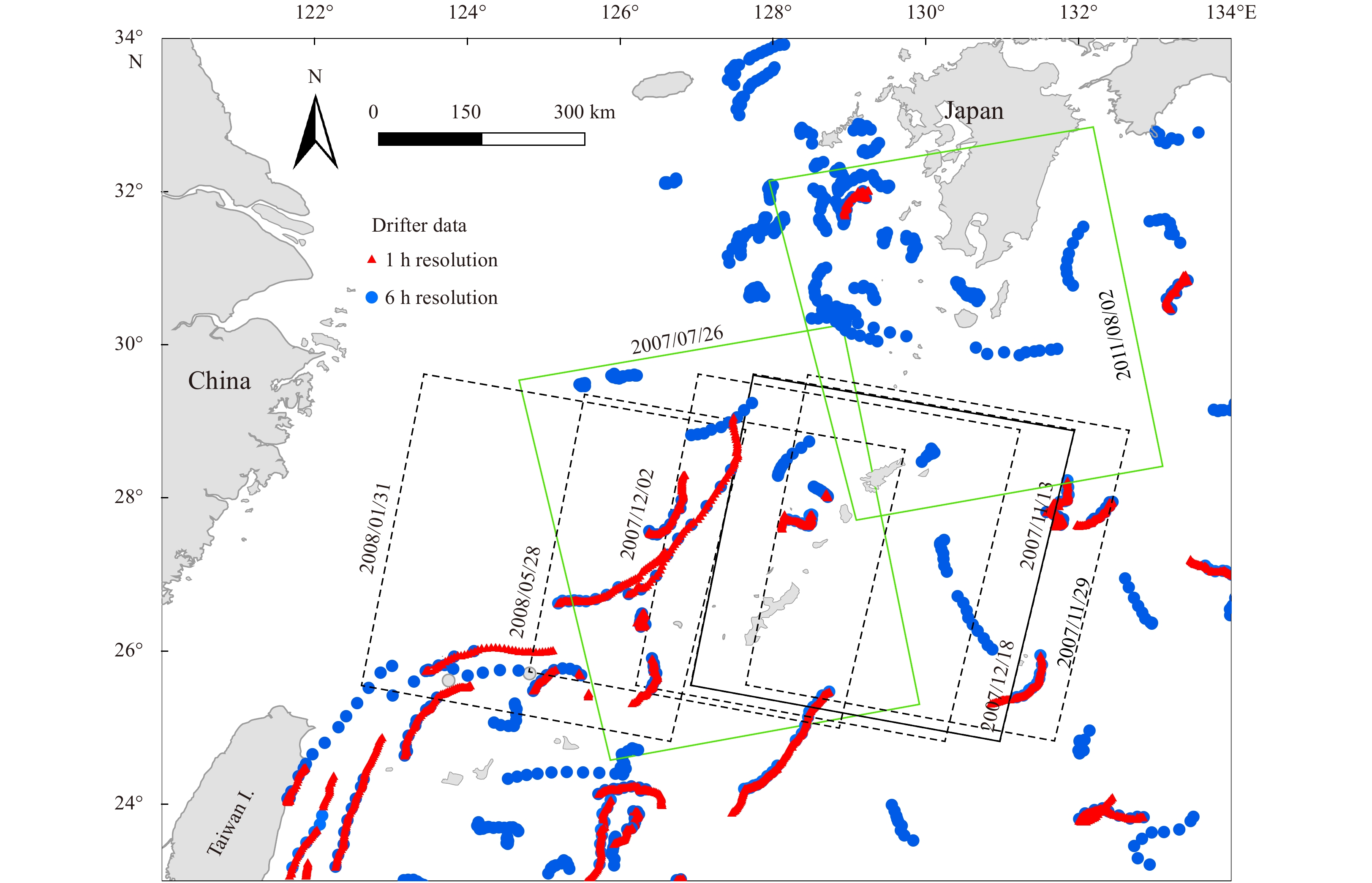
Figure 2. Location of advanced synthetic aperture radar (ASAR) images and surface drifter data. The rectangles show the areas covered by the ASAR images: green and black denote images from ascending and descending orbits, respectively. The dots represent drifter data: red and blue denote data 1-h and 6-h resolutions, respectively.
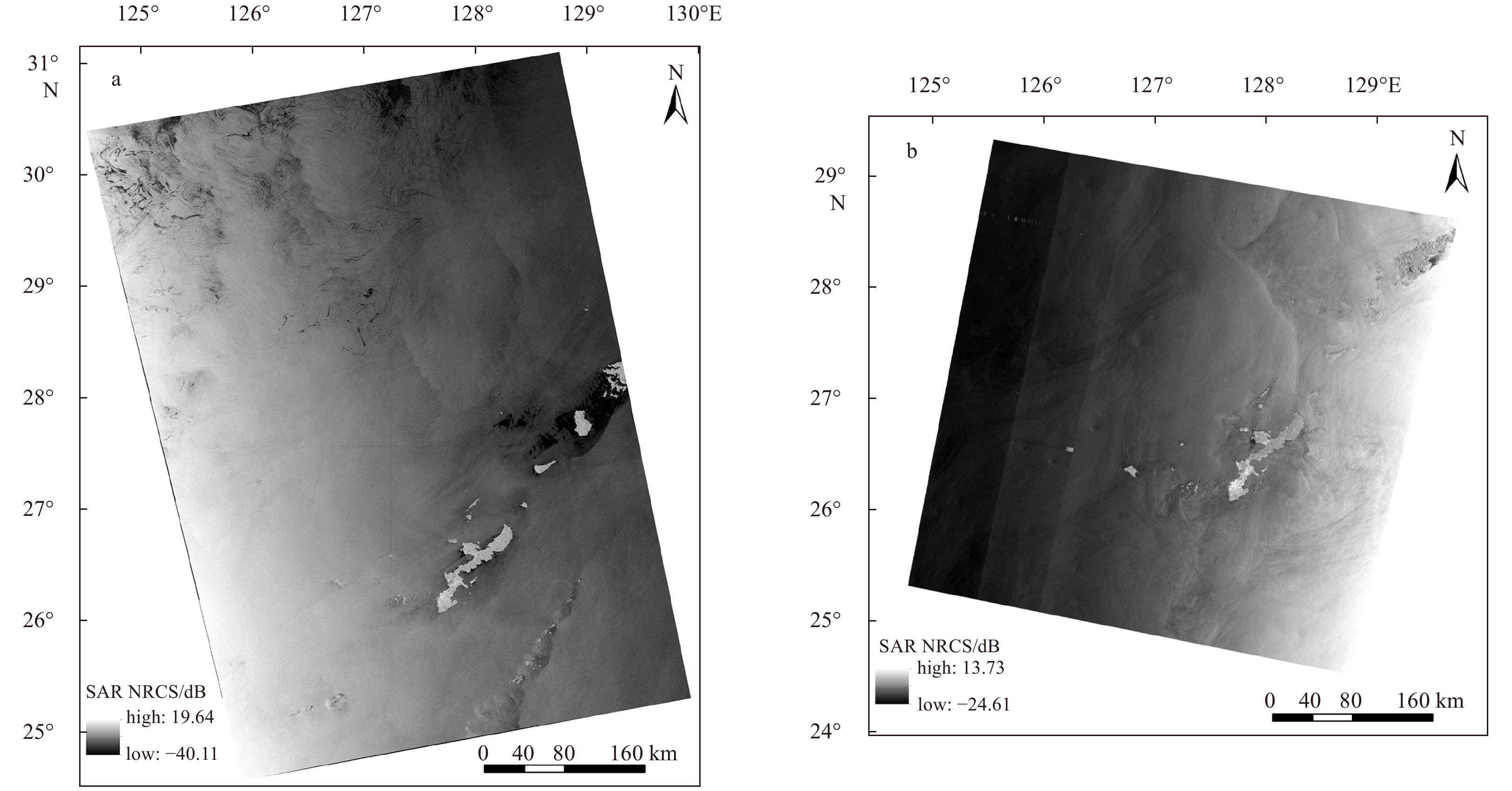
Figure 3. The synthetic aperture radar (SAR) normalized radarcross section (NRCS) image on July 26, 2007 (a), and May 28, 2008 (b).
Figure 4. Flow chart of the inversion method for calculating ocean current from synthetic aperture radar (SAR) data based on Doppler frequency theory.
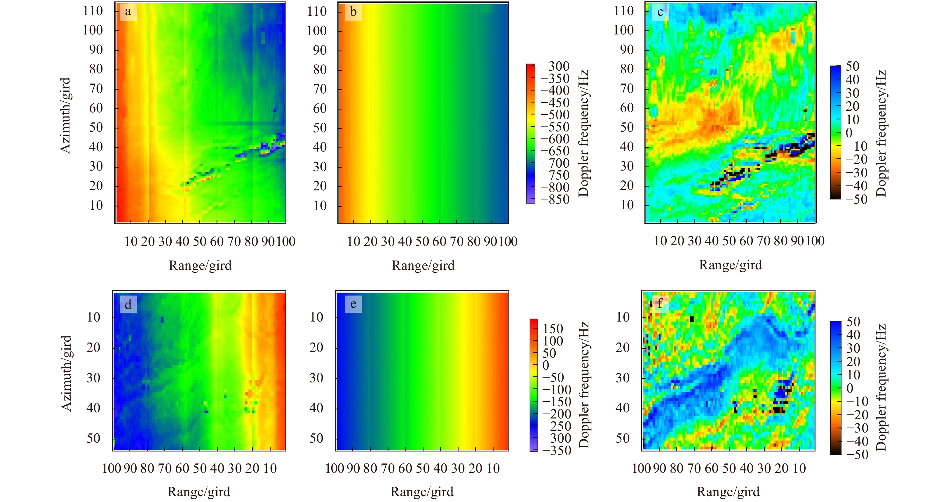
Figure 5. The Doppler centroid grid fDc (a), fDp (b) and fDca (c) from ascending SAR scene on July 26, 2007; and fDc (d), fDp (e) and fDca (f) from SAR descending scene on May 28, 2008.
Figure 6. The geophysical Doppler frequency anomaly fg on July 26, 2007 (a), and on May 28, 2008 (b).
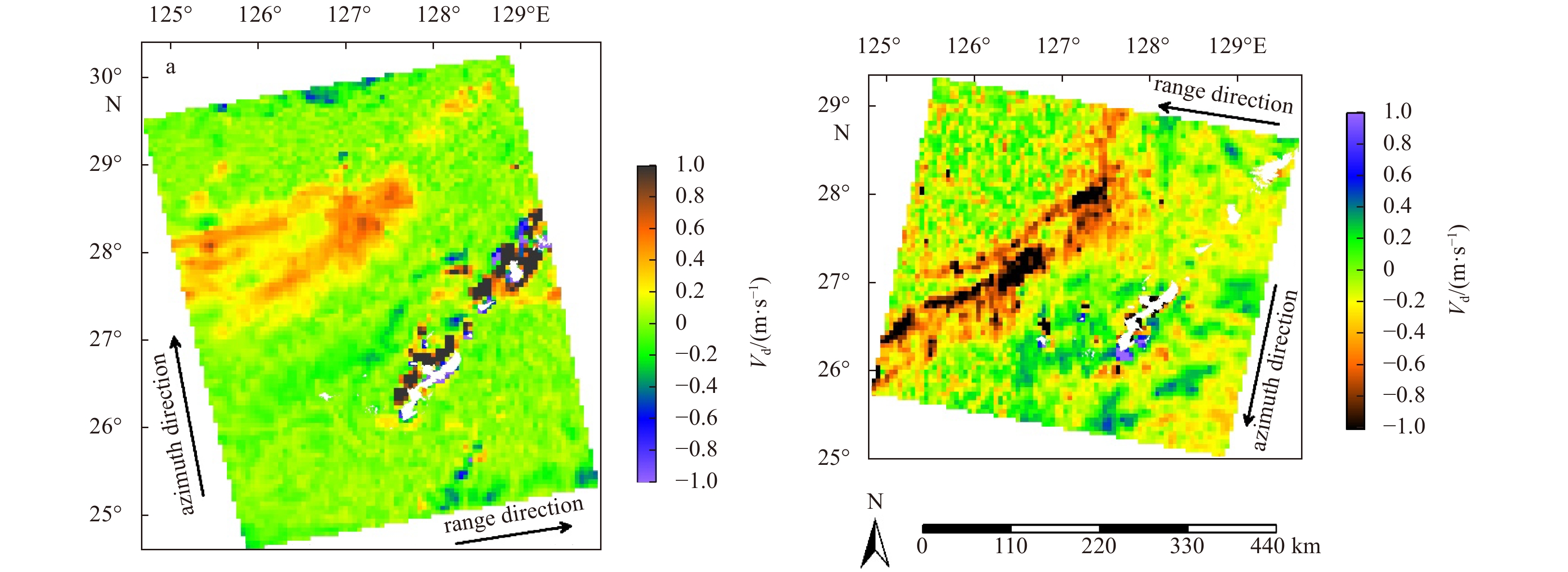
Figure 7. The radial Doppler velocities derived from ASAR scenes on July 26, 2007 (a), and on May 28, 2008 (b). Land is shown in white.
Figure 8. The radial Doppler velocities from the SAR scenes on July 26, 2007 (a), and on May 28, 2008 (b) with the corresponding multi observation (MOB) products superimposed as arrows (arrow length indicates strength); and transects of SAR range velocity and MOB velocity on July 26, 2007 and May 28, 2008 for the Kuroshio central flow (c), and for the Kuroshio Counter Current (d).
Figure 9. Error analysis of the radial velocities. a. Comparing SAR-derived data with the multi observation (MOB) products. b and c. Comparing SAR-derived data with the global surface Lagrangian drifter (GLD) data with the time window of 24 h (b) and 12 h (c).
Figure 10. Composite of SAR radial velocities derived from an ascending scene acquired on 26 July 2007 (middle), an ascending scene acquired on 2 August 2011 (upper right), and a descending scene acquired on 28 May 2008 (lower left).


 DownLoad:

 DownLoad:


 DownLoad: