Afifi Johari, Mohd Fadzil Akhir, Zuraini Zainol, Yue Fang. The extension of the ~3500 km shallow shelf current along the South China Sea: A review[J]. Acta Oceanologica Sinica. doi: 10.1007/s13131-024-0001-1
Citation:
Afifi Johari, Mohd Fadzil Akhir, Zuraini Zainol, Yue Fang. The extension of the ~3500 km shallow shelf current along the South China Sea: A review[J]. Acta Oceanologica Sinica. doi: 10.1007/s13131-024-0001-1
Afifi Johari, Mohd Fadzil Akhir, Zuraini Zainol, Yue Fang. The extension of the ~3500 km shallow shelf current along the South China Sea: A review[J]. Acta Oceanologica Sinica. doi: 10.1007/s13131-024-0001-1
Citation:
Afifi Johari, Mohd Fadzil Akhir, Zuraini Zainol, Yue Fang. The extension of the ~3500 km shallow shelf current along the South China Sea: A review[J]. Acta Oceanologica Sinica. doi: 10.1007/s13131-024-0001-1
Institute of Oceanography and Environment, Universiti Malaysia Terengganu, 21030 Kuala Nerus, Terengganu, Malaysia
2.
Center for Ocean and Climate Research, First Institute of Oceanography, Ministry of Natural Resources, Qingdao, China
Funds:
Long-Term Research Grant Scheme (LRGS: 56041); Interaction of Ocean Dynamics With The Climate System of Past, Present, and Future Using Ocean Observation Integrated Data and Numerical Modeling
Using literature published from 2010 onwards, this study investigates the ~3500 km extension of the shallow shelf current in the South China Sea (SCS) during the winter and summer monsoons. This current is later acknowledged as the South China Sea Shallow Shelf Current (SCSSC). This current is primarily driven by monsoonal winds, and influenced by regional river plumes (Pearl River, Hong River, Mekong River) and the prominent South China Sea Warm Current (SCSWC) and South China Sea Western Boundary Current (SCSWBC). The current exhibits significant seasonal variations in both direction and pattern. During winter, it flows along the northern South China Sea’s (NSCS) shelf and splits into two branches at the east of Hainan Island. One branch enters the Beibu-Tonkin Gulf through the Qiongzhou Strait and forms a major cyclonic circulation within the gulf, while the other branch flows southwestward along the southern coast of Hainan Island. These branches converge around 16°N latitude at the east of the Vietnamese shelf, then flow southward along the Sunda Shelf, where they deflect southwestward in “broadband” forms before curving southeastward along the east coast of Peninsular Malaysia (ECPM) and exiting via the Karimata Strait. In summer, the current exhibits a complex pattern. At the Sunda Shelf, it flows northwestward along the ECPM, then deflects northeastward around 6°N latitude, forming the Sunda Shelf’s anti-cyclonic eddy (SSE) and causing upwelling on the east coast of Peninsular Malaysia (ECPMU). Near the eastern Vietnamese shelf, the current splits around 11-12°N latitude into three distinct currents: the southward-flowing Vietnam Current, the northward-flowing Vietnam Meandering Current (VMC), and the southward-flowing SCSWBC. The VMC flows northward and then deflects northeastward south of Hainan Island, continuing northeastward along the NSCS’s shelf and exiting through the Taiwan Strait.
Figure 1. Bathymetry and topography map of the South China Sea (SCS). The red-shaded area inside the red dashed line indicates the domain of the whole SCS domain according to Weng et al. (2016). There are three sub-domains inside the SCS justified in this paper, and named as northern of SCS (NSCS), southern of SCS (SSCS), and Sunda Shelf to ease the reference for readers. The black-dashed arrow is the illustration of the ~3500 km of the boundary current discussed in this article.
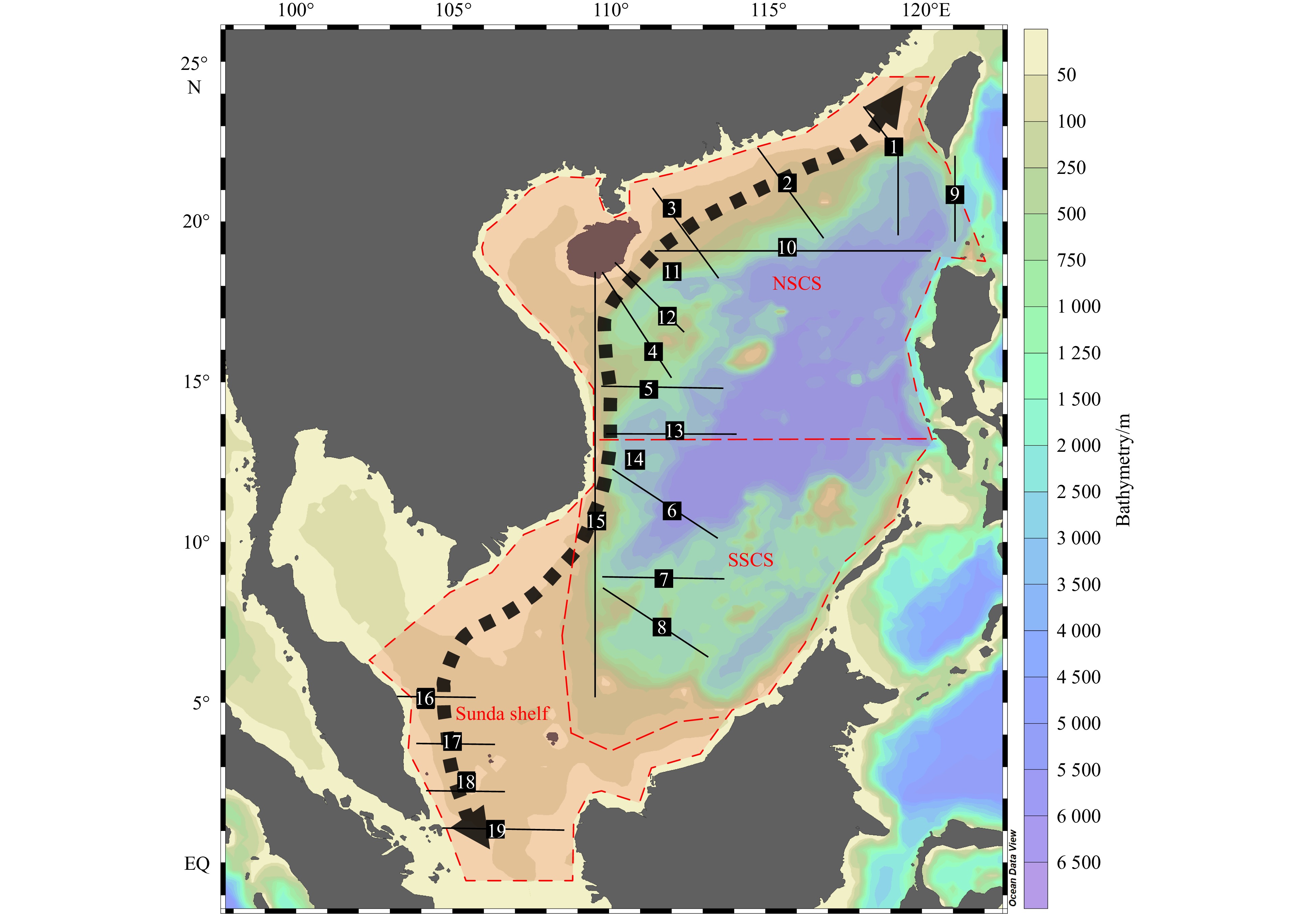
Figure 2. Observed transects and stations for boundary currents studies in the SCS. All these transects described the velocity or the volume transport by the previous authors, as tabulated in Table 2. The red-shaded area inside the red dashed line indicates the domain of the whole SCS domain according to (Weng et al., 2016). There are three sub-domains inside the SCS justified in this paper, and named as NSCS, SSCS, and Sunda Shelf to ease the reference for readers. The black-dashed arrow is the illustration of the ~3500 km of the boundary current discussed in this article.
Figure 3. As illustrated in the blue arrow, the schematic diagram for the extension of the South China Sea Shallow Shelf Current (SCSSC) during the winter monsoon. The name for each current as numbered in the figure is tabulated in Table 3.
Figure 4. As illustrated in the red arrow, the schematic diagram for the extension of the South China Sea Shallow Shelf Current (SCSSC) during the summer monsoon. The name for each current as numbered in the figure is tabulated in Table 3.


 DownLoad: