
LOGIN

Most Cited
- Green synthesis of iron oxide (Fe3O4) nanoparticles using two selected brown seaweeds: Characterization and application for lead bioremediation
- A nowcasting model for the prediction of typhoon tracks based on a long short term memory neural network
- The first Sentinel-1 SAR image of a typhoon
- Effect of temperature, salinity and irradiance on growth and photosynthesis of Ulva prolifera
- Sediment discharge of the Yellow River, China: past, present and future-A synthesis
Articles in press have been peer-reviewed and accepted, which are not yet assigned to volumes /issues, but are citable by Digital Object Identifier (DOI).
Display Method:
, Available online ,
doi: 10.1007/s13131-024-2443-3
Abstract:
The impacts of the Luzon Strait transport on shallow meridional overturning circulation (SMOC) in the South China Sea (SCS) have been pointed out by previous studies, but the issue whether the Luzon Strait transport dominates the SMOC formation still remains open. The Helmholtz decomposition is applied based on OFES products to address this issue. Results show that the motion caused by the Luzon Strait transport is characterized as an obvious southward flow between 13°N and 20°N. After this motion being removed, the clockwise winter SMOC and the anticlockwise summer SMOC can still exist significantly. The SMOC existence and its seasonal variation are also reproduced in the numerical simulation with the Luzon Strait closed. Both results of the Helmholtz decomposition and numerical experiment suggest that the SMOC formation and its seasonal variation are not dominated by the Luzon Strait transport. The SCS monsoon is the primary driving factor for the SMOC, which is related to the physical processes within the SCS.
The impacts of the Luzon Strait transport on shallow meridional overturning circulation (SMOC) in the South China Sea (SCS) have been pointed out by previous studies, but the issue whether the Luzon Strait transport dominates the SMOC formation still remains open. The Helmholtz decomposition is applied based on OFES products to address this issue. Results show that the motion caused by the Luzon Strait transport is characterized as an obvious southward flow between 13°N and 20°N. After this motion being removed, the clockwise winter SMOC and the anticlockwise summer SMOC can still exist significantly. The SMOC existence and its seasonal variation are also reproduced in the numerical simulation with the Luzon Strait closed. Both results of the Helmholtz decomposition and numerical experiment suggest that the SMOC formation and its seasonal variation are not dominated by the Luzon Strait transport. The SCS monsoon is the primary driving factor for the SMOC, which is related to the physical processes within the SCS.


, Available online ,
doi: 10.1007/s13131-024-2366-z
Abstract:
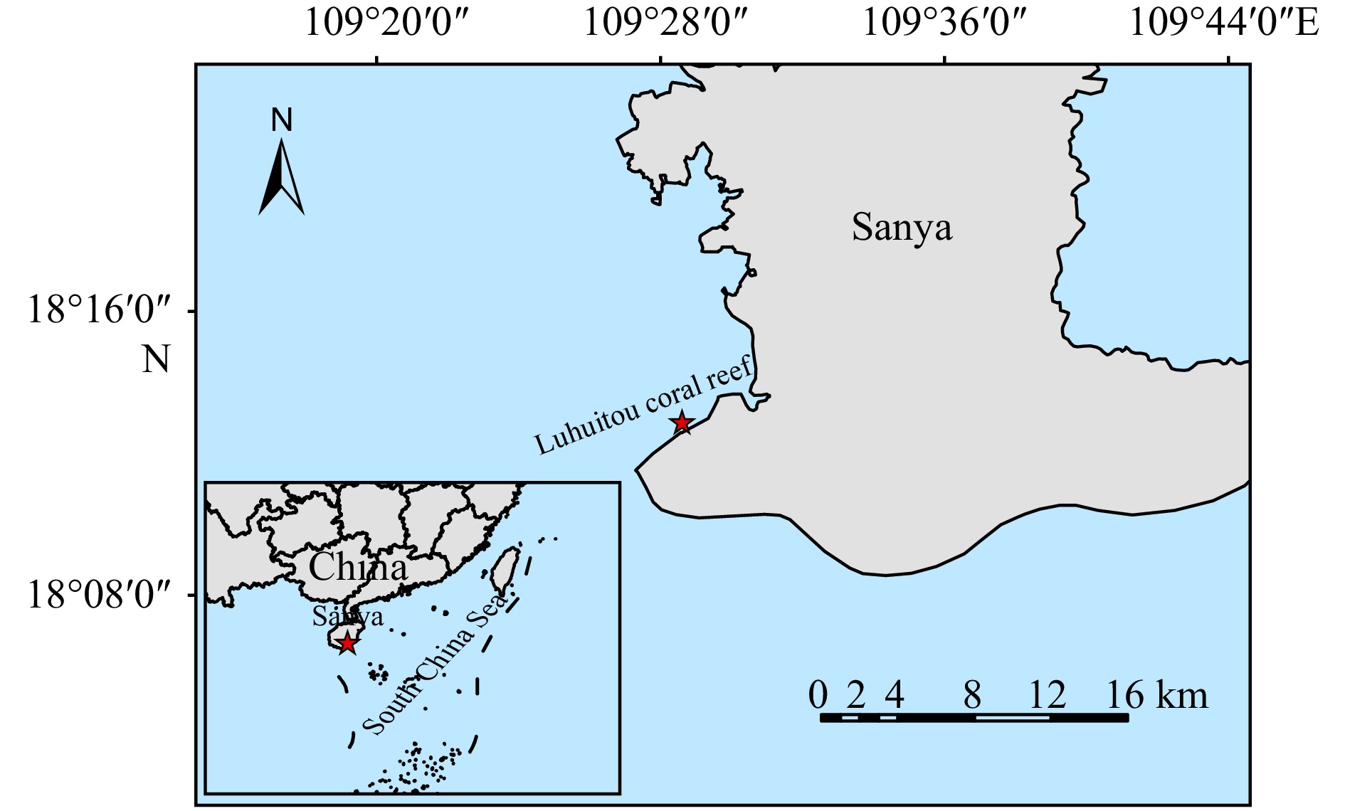
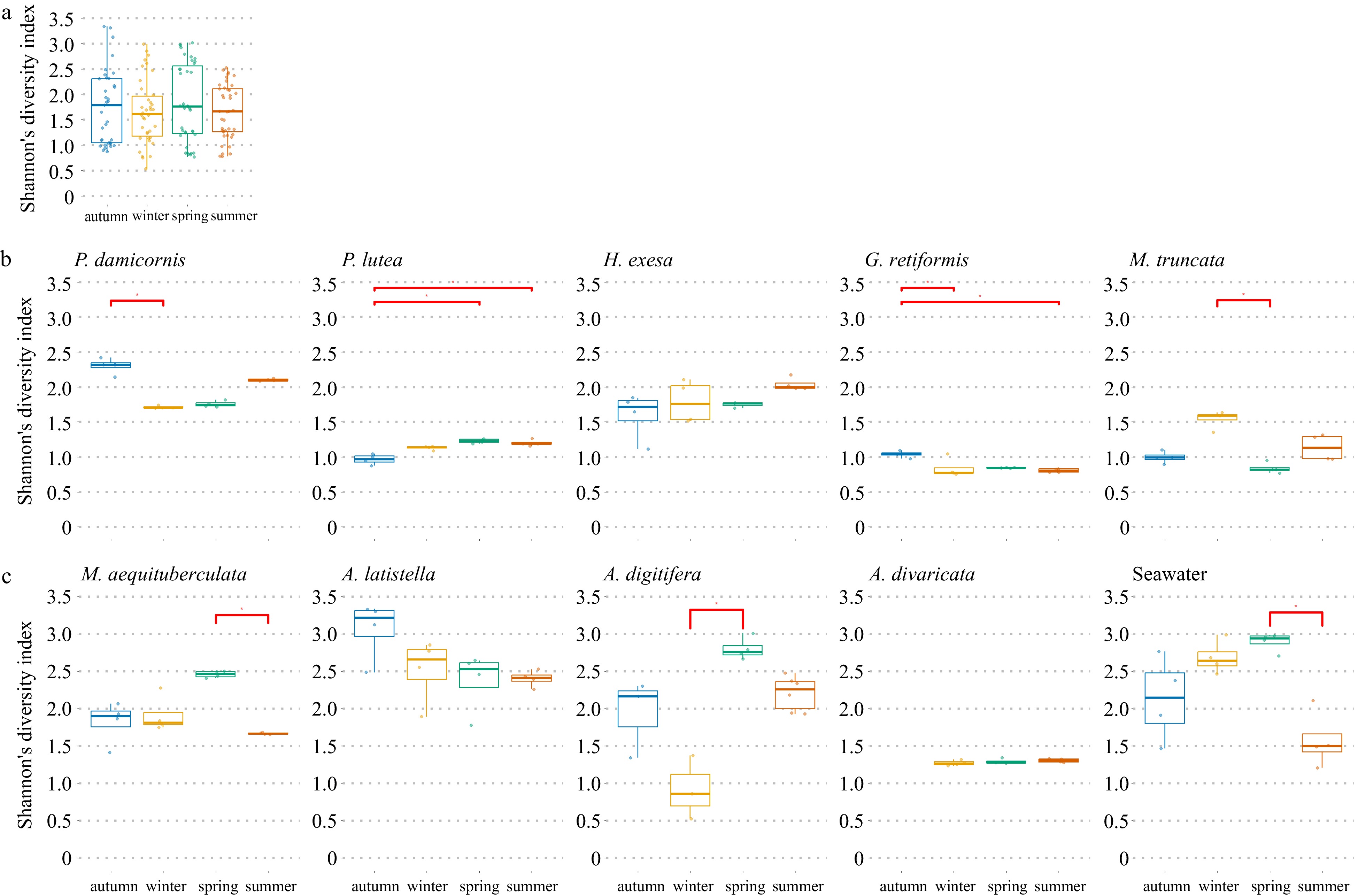
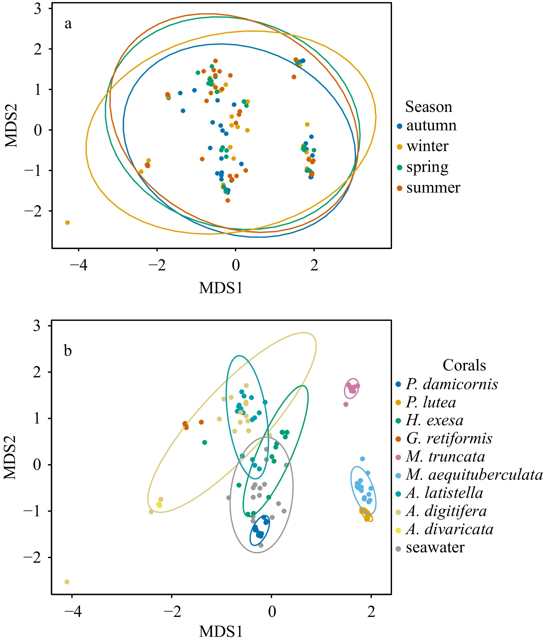
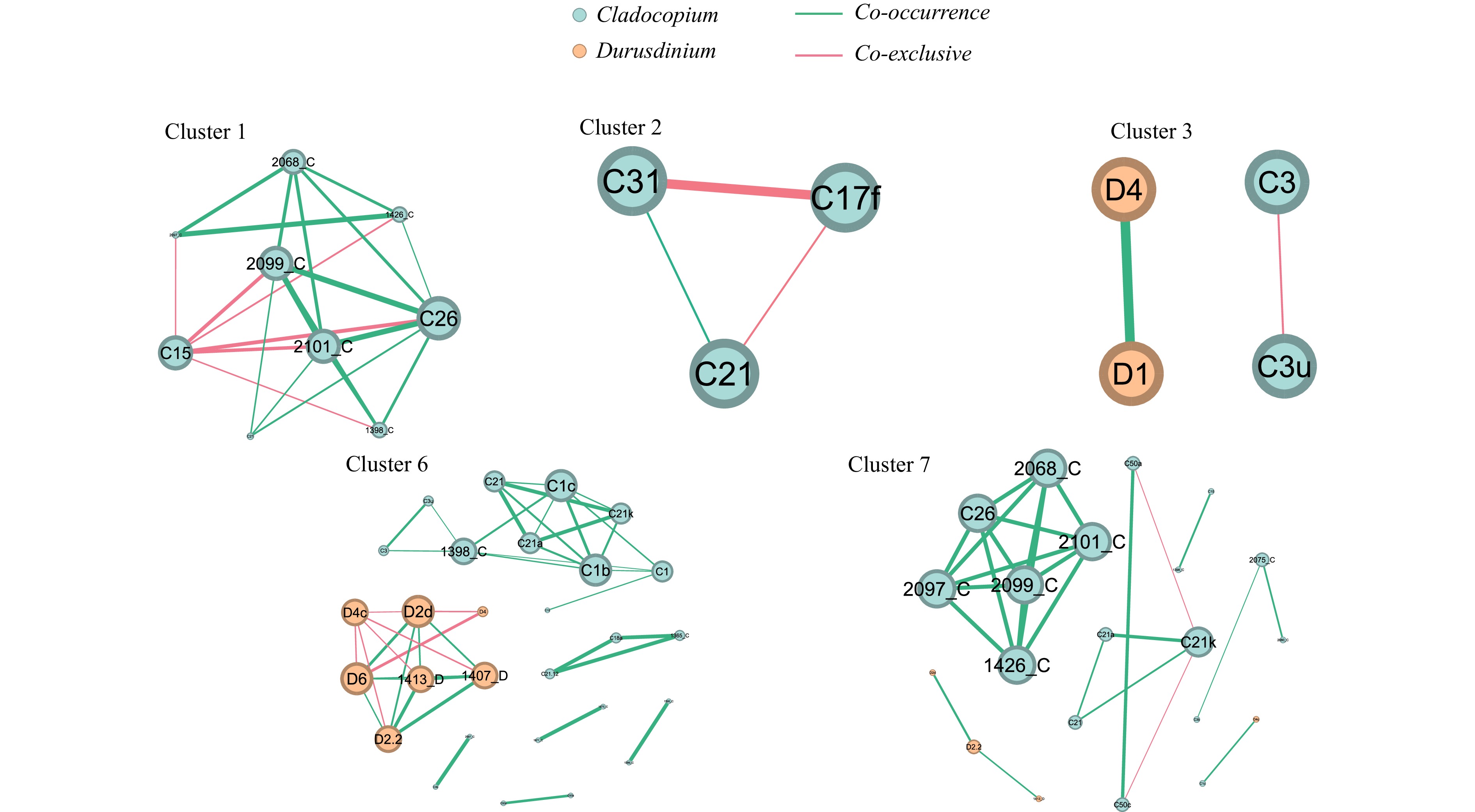
The symbiotic association between reef-building corals and Symbiodiniaceae is pivotal for coral reef ecosystems, yet remains susceptible to environmental factors. Currently, there is a dearth of research examining seasonal fluctuations in coral-associated Symbiodiniaceae communities. In this study, we investigated the seasonal dynamics of Symbiodiniaceae communities associated with coral species in the Luhuitou coral reef using high-throughput sequencing techniques and SymPortal analytical framework. The results indicated that the genus Cladocopium exhibited dominance (averaging 82%), followed by Durusdinium (18%) and Breviolum (0.01%) within the examined coral species. Among the 521 Symbiodiniaceae ITS2 sequence types, C15 emerged as the prevalent type (13.24%), trailed by C3u (9.51%) and D1 (8.57%). Interestingly, Symbiodiniaceae communities varied among different coral species. Pocillopora damicornis displayed a predominant association with Durusdinium, while Porites lutea, Goniastrea retiformis, Montipora truncata, Montipora aequituberculata, and Acropora divaricata were entirely dominated by the genus Cladocopium (100%), showcasing distinct host specificity. In the cases of Hydnophora exesa, Acropora latistella, Acropora digitifera, and seawater, both Cladocopium and Durusdinium were concurrently detected. Moreover, the diversity of Symbiodiniaceae associated with P. damicornis, P. lutea, G. retiformis, M. truncata, M. aequituberculata, and A. digitifera exhibited significant variations across different seasons. Notably, the results revealed that the alterations in Symbiodiniaceae community compositions were primarily driven by nutrient concentrations and seawater temperature. The network analysis of Symbiodiniaceae revealed the dominant Symbiodiniaceae types C15, C17f, C3u, C3, and D4 were exclusive. This study provided the seasonal variation characteristics of Symbiodiniaceae communities among different coral species, which may be a potential adaptive mechanism to environmental conditions.
The symbiotic association between reef-building corals and Symbiodiniaceae is pivotal for coral reef ecosystems, yet remains susceptible to environmental factors. Currently, there is a dearth of research examining seasonal fluctuations in coral-associated Symbiodiniaceae communities. In this study, we investigated the seasonal dynamics of Symbiodiniaceae communities associated with coral species in the Luhuitou coral reef using high-throughput sequencing techniques and SymPortal analytical framework. The results indicated that the genus Cladocopium exhibited dominance (averaging 82%), followed by Durusdinium (18%) and Breviolum (0.01%) within the examined coral species. Among the 521 Symbiodiniaceae ITS2 sequence types, C15 emerged as the prevalent type (13.24%), trailed by C3u (9.51%) and D1 (8.57%). Interestingly, Symbiodiniaceae communities varied among different coral species. Pocillopora damicornis displayed a predominant association with Durusdinium, while Porites lutea, Goniastrea retiformis, Montipora truncata, Montipora aequituberculata, and Acropora divaricata were entirely dominated by the genus Cladocopium (100%), showcasing distinct host specificity. In the cases of Hydnophora exesa, Acropora latistella, Acropora digitifera, and seawater, both Cladocopium and Durusdinium were concurrently detected. Moreover, the diversity of Symbiodiniaceae associated with P. damicornis, P. lutea, G. retiformis, M. truncata, M. aequituberculata, and A. digitifera exhibited significant variations across different seasons. Notably, the results revealed that the alterations in Symbiodiniaceae community compositions were primarily driven by nutrient concentrations and seawater temperature. The network analysis of Symbiodiniaceae revealed the dominant Symbiodiniaceae types C15, C17f, C3u, C3, and D4 were exclusive. This study provided the seasonal variation characteristics of Symbiodiniaceae communities among different coral species, which may be a potential adaptive mechanism to environmental conditions.


, Available online ,
doi: 10.1007/s13131-024-2390-z
Abstract:
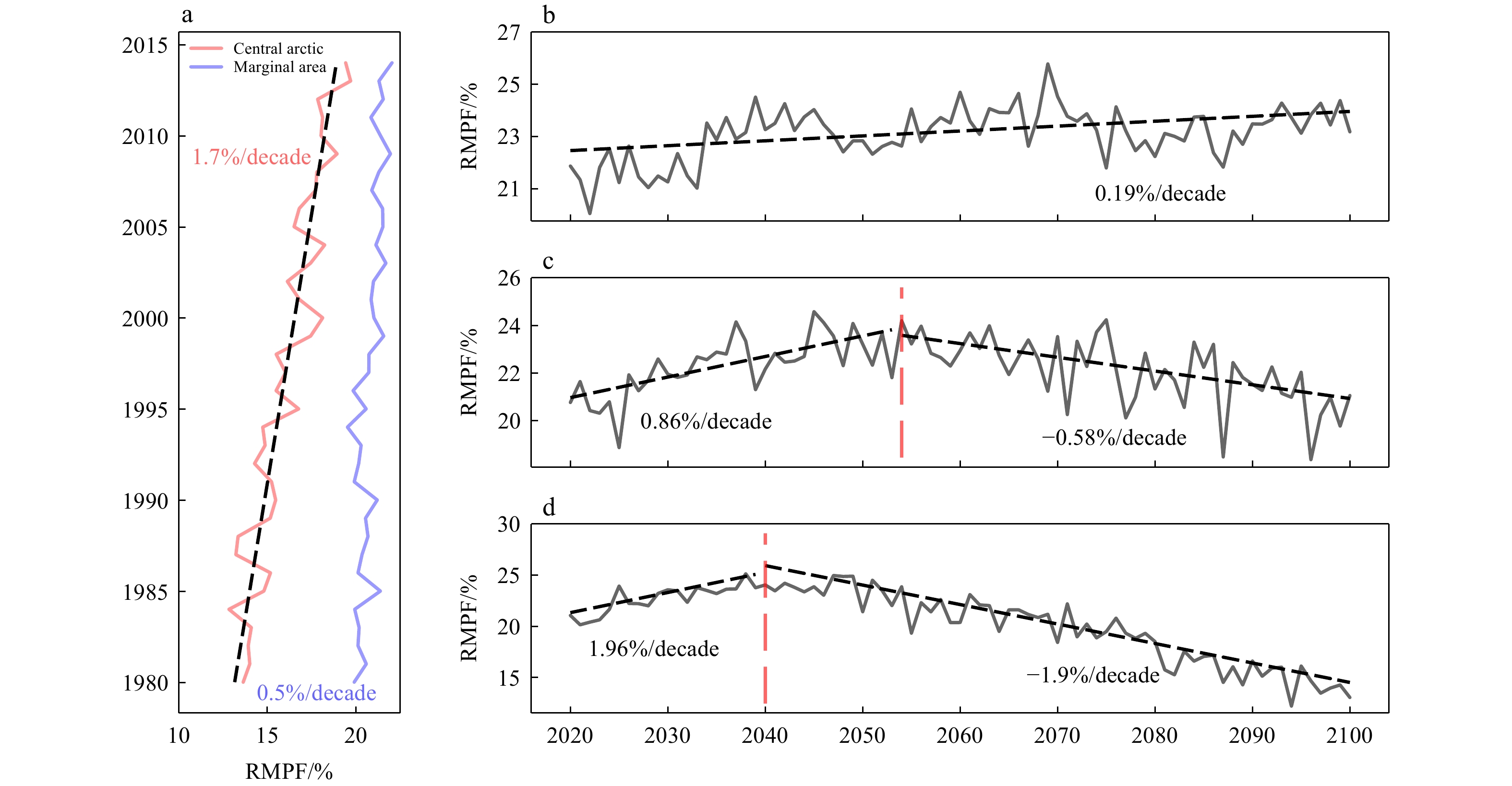
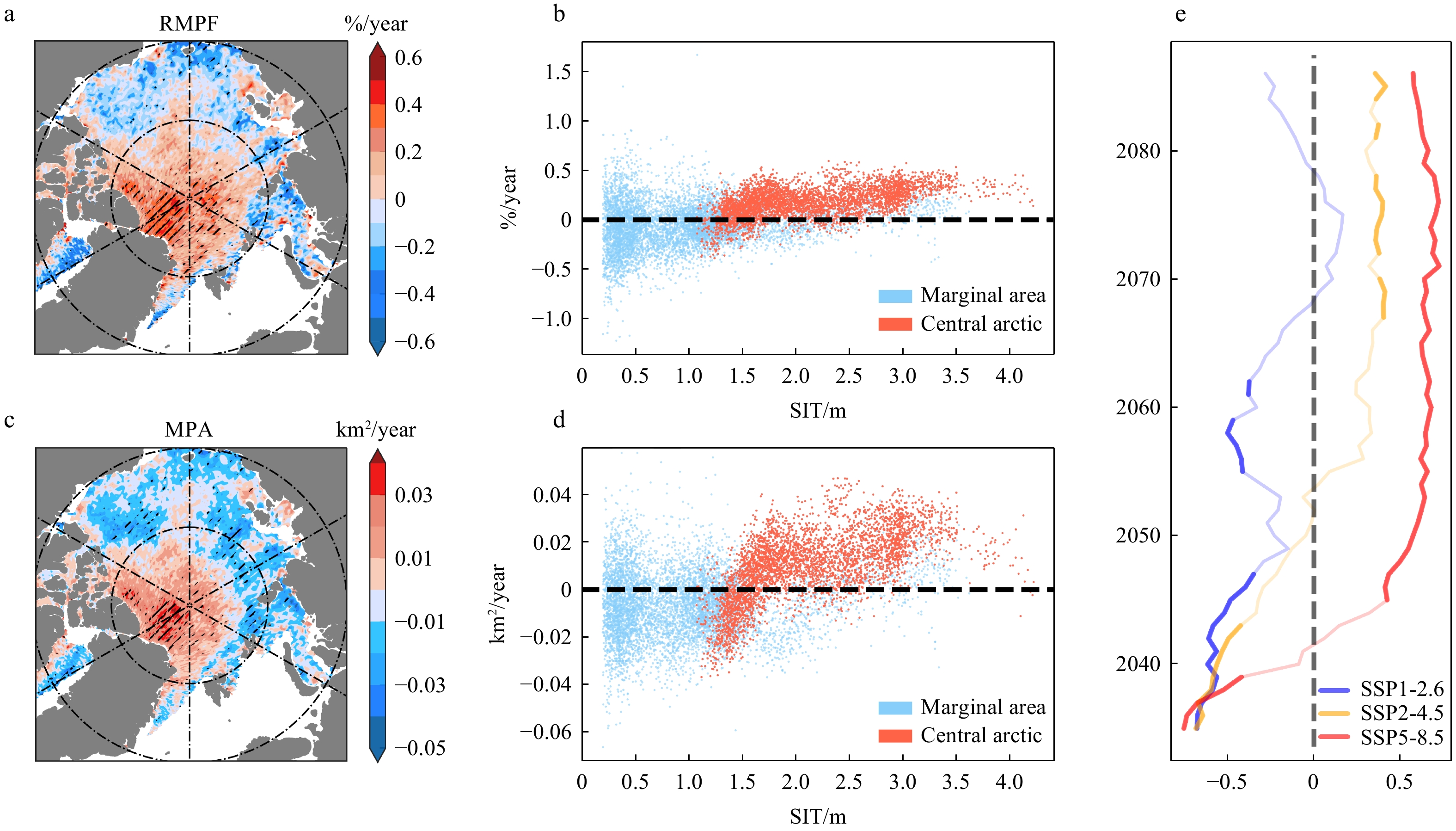
Melt ponds are significant physical features on the ice surface throughout the Arctic summer, and the scarcity of observational data has resulted in a vague understanding about it. This study employs satellite data and multi-model averaged outputs from CMIP6 to analyze the spatiotemporal evolution characteristics of Arctic melt ponds and their relationship with sea ice thickness (SIT) and atmospheric energy flux. The ponds first emerge at lower latitudes and gradually extend to cover central ice areas as the season progresses, then persisting longer and covering larger total areas in the central region, with peak areas exceeding 0.6 million km2, which is 4 to 5 times that of other marginal areas. Over the past two decades, pond coverage has exhibited markedly different trends with slight decreases in the marginal seas but significant increases in the central area. Both CMIP6 and satellite data indicate that the sea ice carrying capacity, related to thickness, plays a crucial role in creating these differences. There is a marked increasing pond in areas with thicker ice. When the SIT falls below a certain threshold, however, sea ice melting results in decreased pond coverage. Additionally, the energy balance on the ice surface also dramatically impacts pond changes. For instance, the overall pond changes in central area are influenced by net longwave radiation (NLR) and latent heat (LH), with anomalies in these fluxes correlating highly (up to 0.8) with pond anomalies. Meanwhile, net shortwave radiation (NSR) primarily causes local pond anomalies through the pond-shortwave feedback only under the clear weather conditions.
Melt ponds are significant physical features on the ice surface throughout the Arctic summer, and the scarcity of observational data has resulted in a vague understanding about it. This study employs satellite data and multi-model averaged outputs from CMIP6 to analyze the spatiotemporal evolution characteristics of Arctic melt ponds and their relationship with sea ice thickness (SIT) and atmospheric energy flux. The ponds first emerge at lower latitudes and gradually extend to cover central ice areas as the season progresses, then persisting longer and covering larger total areas in the central region, with peak areas exceeding 0.6 million km2, which is 4 to 5 times that of other marginal areas. Over the past two decades, pond coverage has exhibited markedly different trends with slight decreases in the marginal seas but significant increases in the central area. Both CMIP6 and satellite data indicate that the sea ice carrying capacity, related to thickness, plays a crucial role in creating these differences. There is a marked increasing pond in areas with thicker ice. When the SIT falls below a certain threshold, however, sea ice melting results in decreased pond coverage. Additionally, the energy balance on the ice surface also dramatically impacts pond changes. For instance, the overall pond changes in central area are influenced by net longwave radiation (NLR) and latent heat (LH), with anomalies in these fluxes correlating highly (up to 0.8) with pond anomalies. Meanwhile, net shortwave radiation (NSR) primarily causes local pond anomalies through the pond-shortwave feedback only under the clear weather conditions.


, Available online ,
doi: 10.1007/s13131-024-0001-4
Abstract:
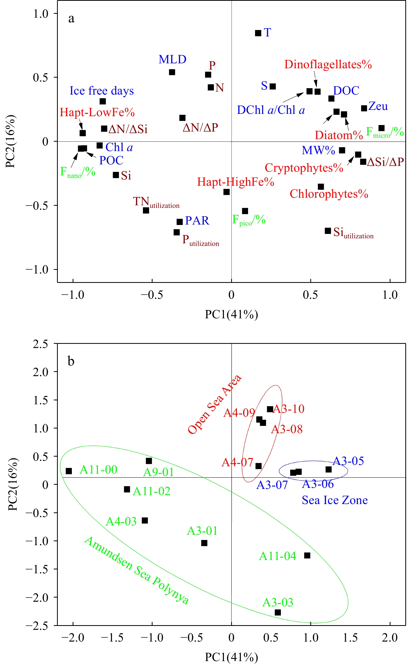
Polynyas and their adjacent seasonal ice zones (SIZs) represent the most productive regions in the Southern Ocean, supporting unique food webs that are highly sensitive to climate change. Understanding the dynamics of phytoplankton and the carbon pool in these areas is crucial for assessing the role of the southern ocean in global carbon cycling. During the late stage of an algal bloom, seawater samples were collected at 14 stations were collected in the Amundsen Sea Polynya (ASP) and adjacent SIZ. Using nutrients, phytoplankton pigments, organic carbon (OC), remote sensing data, and physicochemical measurements, as well as CHEMTAX model simulations, we investigated the response of the phytoplankton crops, taxonomic composition, and OC pool to environmental factors. Our analyses revealed that hydrodynamic regimes of the polynya, adjacent SIZs and open sea were regulated by the regionally varying intrusion of Circumpolar Deep Water, photosynthetically active radiation and sea ice melt water. The ASP exhibited the highest seasonal nutrient utilization rates (ΔN =1059 ± 386 mmol/m2, ΔP = 50 ± 17 mmol/m2 and ΔSi = 956 ± 904 mmol/m2), while the open sea had lower rates. The integrated chlorophyll a (Chl a) concentrations at depths of 0–200 m ranged from 20.4 mg/m2 to 1420.0 mg/m2 and peaked in the polynya. In the study area, Haptophytes P. antarctica was the dominant functional group (34% ± 27%), and diatoms acted as a secondary contributor (23% ± 14%). The major functional group and particulate OC (POC) contributor varied from diatoms (36% ± 12%) in the open sea to haptophytes (48% ± 31%) in the polynya waters. Strong light conditions and microelement limitations promoted the dominance of P. antarctica (low Fe forms) dominance in the ASP. The strong correlations between the POC and Chl a concentrations suggest that the POC was primarily derived from phytoplankton, while the dissolved OC (DOC) was influenced by consumer activity and water mass transport. In addition, the transport of OC in the upper 200 m of the water column within the ASP was quantified, revealing the predominantly westward fluxes for both DOC (9.0 mg OC·m−2·s−1) and POC (7.2 mg OC·m−2·s−1). The latitudinal transport exhibited the northward transport of DOC (8.1 mg OC·m−2·s−1) and southward transport of POC (4.3 mg OC·m−2·s−1) movement. These findings have significant implications for enhancing our understanding of how hydrodynamics influence OC cycling in polynya regions.
Polynyas and their adjacent seasonal ice zones (SIZs) represent the most productive regions in the Southern Ocean, supporting unique food webs that are highly sensitive to climate change. Understanding the dynamics of phytoplankton and the carbon pool in these areas is crucial for assessing the role of the southern ocean in global carbon cycling. During the late stage of an algal bloom, seawater samples were collected at 14 stations were collected in the Amundsen Sea Polynya (ASP) and adjacent SIZ. Using nutrients, phytoplankton pigments, organic carbon (OC), remote sensing data, and physicochemical measurements, as well as CHEMTAX model simulations, we investigated the response of the phytoplankton crops, taxonomic composition, and OC pool to environmental factors. Our analyses revealed that hydrodynamic regimes of the polynya, adjacent SIZs and open sea were regulated by the regionally varying intrusion of Circumpolar Deep Water, photosynthetically active radiation and sea ice melt water. The ASP exhibited the highest seasonal nutrient utilization rates (ΔN =


, Available online ,
doi: 10.1007/s13131-024-0001-3
Abstract:
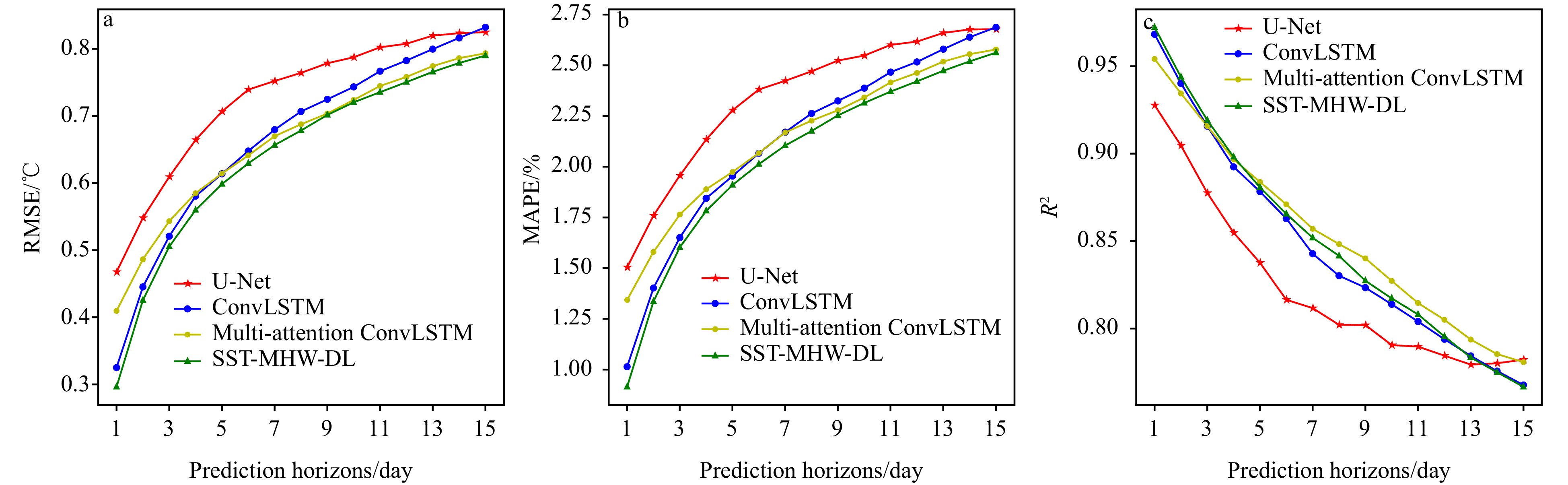
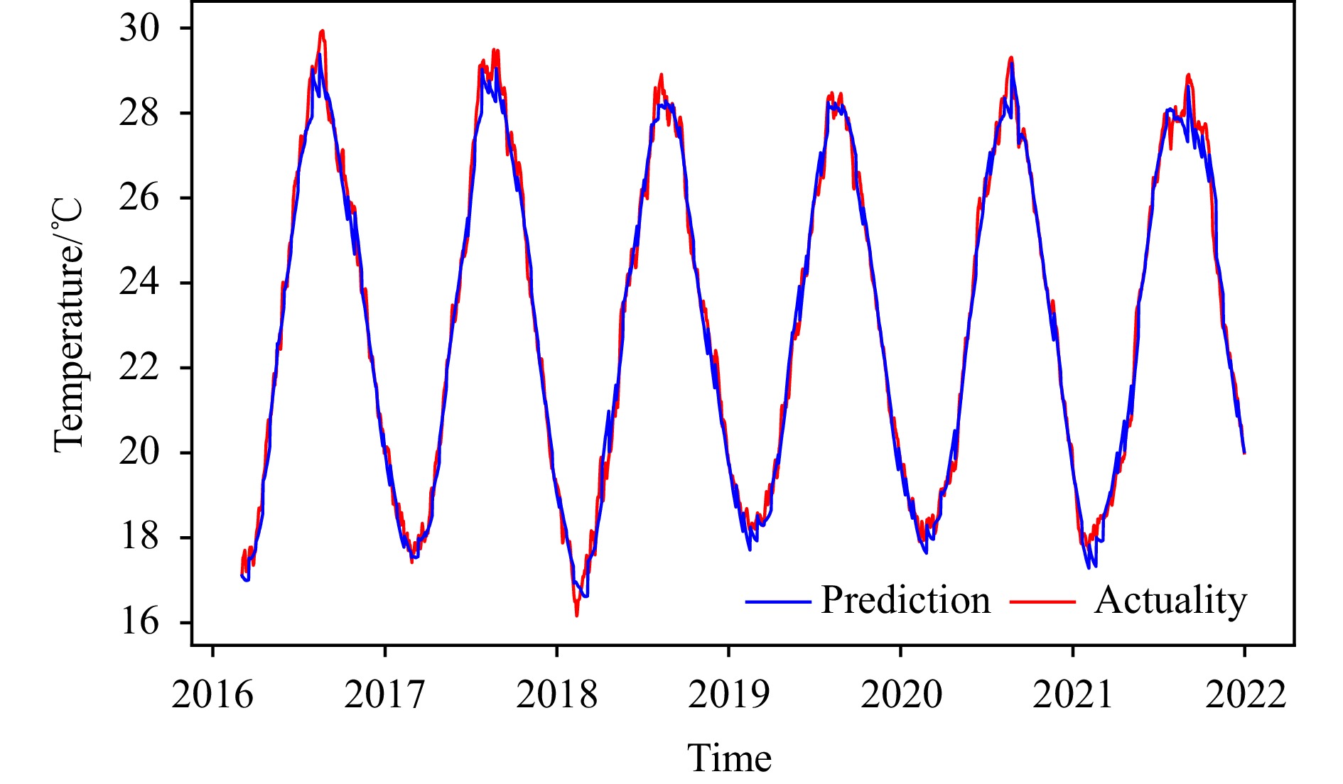
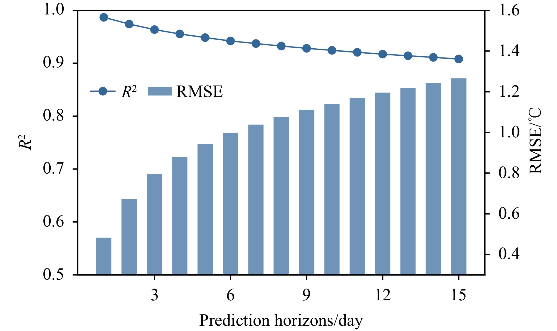
Marine Heatwave (MHW) events refer to periods of significantly elevated sea surface temperatures (SST), persisting from days to months, with significant impacts on marine ecosystems, including increased mortality among marine life and coral bleaching. Forecasting MHW events is crucial to mitigate their harmful effects. This study presents a two-step forecasting process: short-term SST prediction followed by MHW event detection based on the forecasted SST. Firstly, we developed the “SST-MHW-DL” model using the ConvLSTM architecture, which incorporates an attention mechanism to enhance both SST forecasting and MHW event detection. The model utilizes SST data from the preceding 60 days to forecast SST and detect MHW events for the subsequent 15 days. Verification results for SST forecasting demonstrate a Root Mean Square Error (RMSE) of 0.64℃, a Mean Absolute Percentage Error (MAPE) of 2.05%, and a coefficient of determination (R²) of 0.85, indicating the model’s ability to accurately predict future temperatures by leveraging historical sea temperature information. For MHW event detection using forecasted SST, the evaluation metrics of “accuracy,” “precision,” and “recall” achieved values of 0.77, 0.73, and 0.43, respectively, demonstrating the model’s capability to capture the occurrence of MHW events accurately. Furthermore, the attention-enhanced mechanism reveals that recent SST variations within the past 10 days have the most significant impact on forecasting accuracy, while variations in deep-sea regions and along the Taiwan Strait significantly contribute to the model’s efficacy in capturing spatial characteristics. Additionally, the proposed model and temporal mechanism were applied to detect MHWs in the Atlantic Ocean. By inputting 30 days of SST data, the model predicted SST with an RMSE of 1.02℃ and an R² of 0.94. The accuracy, precision, and recall for MHW detection were 0.79, 0.78, and 0.62, respectively, further demonstrating the model’s robustness and usability.
Marine Heatwave (MHW) events refer to periods of significantly elevated sea surface temperatures (SST), persisting from days to months, with significant impacts on marine ecosystems, including increased mortality among marine life and coral bleaching. Forecasting MHW events is crucial to mitigate their harmful effects. This study presents a two-step forecasting process: short-term SST prediction followed by MHW event detection based on the forecasted SST. Firstly, we developed the “SST-MHW-DL” model using the ConvLSTM architecture, which incorporates an attention mechanism to enhance both SST forecasting and MHW event detection. The model utilizes SST data from the preceding 60 days to forecast SST and detect MHW events for the subsequent 15 days. Verification results for SST forecasting demonstrate a Root Mean Square Error (RMSE) of 0.64℃, a Mean Absolute Percentage Error (MAPE) of 2.05%, and a coefficient of determination (R²) of 0.85, indicating the model’s ability to accurately predict future temperatures by leveraging historical sea temperature information. For MHW event detection using forecasted SST, the evaluation metrics of “accuracy,” “precision,” and “recall” achieved values of 0.77, 0.73, and 0.43, respectively, demonstrating the model’s capability to capture the occurrence of MHW events accurately. Furthermore, the attention-enhanced mechanism reveals that recent SST variations within the past 10 days have the most significant impact on forecasting accuracy, while variations in deep-sea regions and along the Taiwan Strait significantly contribute to the model’s efficacy in capturing spatial characteristics. Additionally, the proposed model and temporal mechanism were applied to detect MHWs in the Atlantic Ocean. By inputting 30 days of SST data, the model predicted SST with an RMSE of 1.02℃ and an R² of 0.94. The accuracy, precision, and recall for MHW detection were 0.79, 0.78, and 0.62, respectively, further demonstrating the model’s robustness and usability.


, Available online ,
doi: 10.1007/s13131-024-0001-2
Abstract:
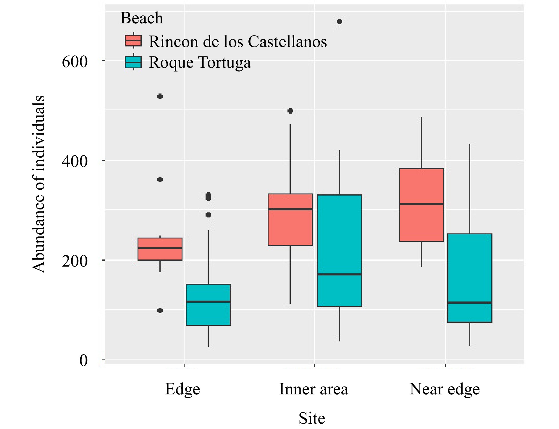
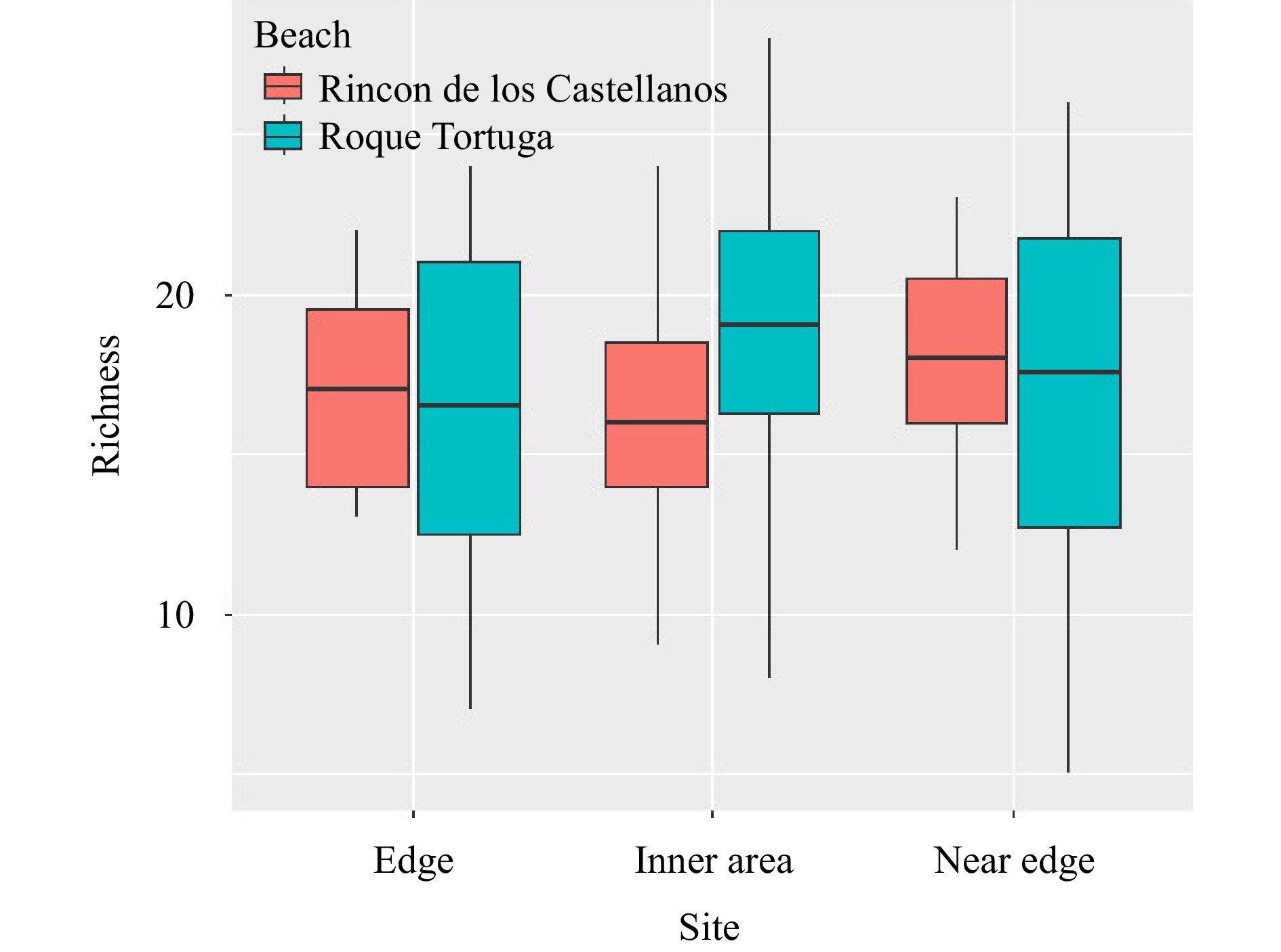
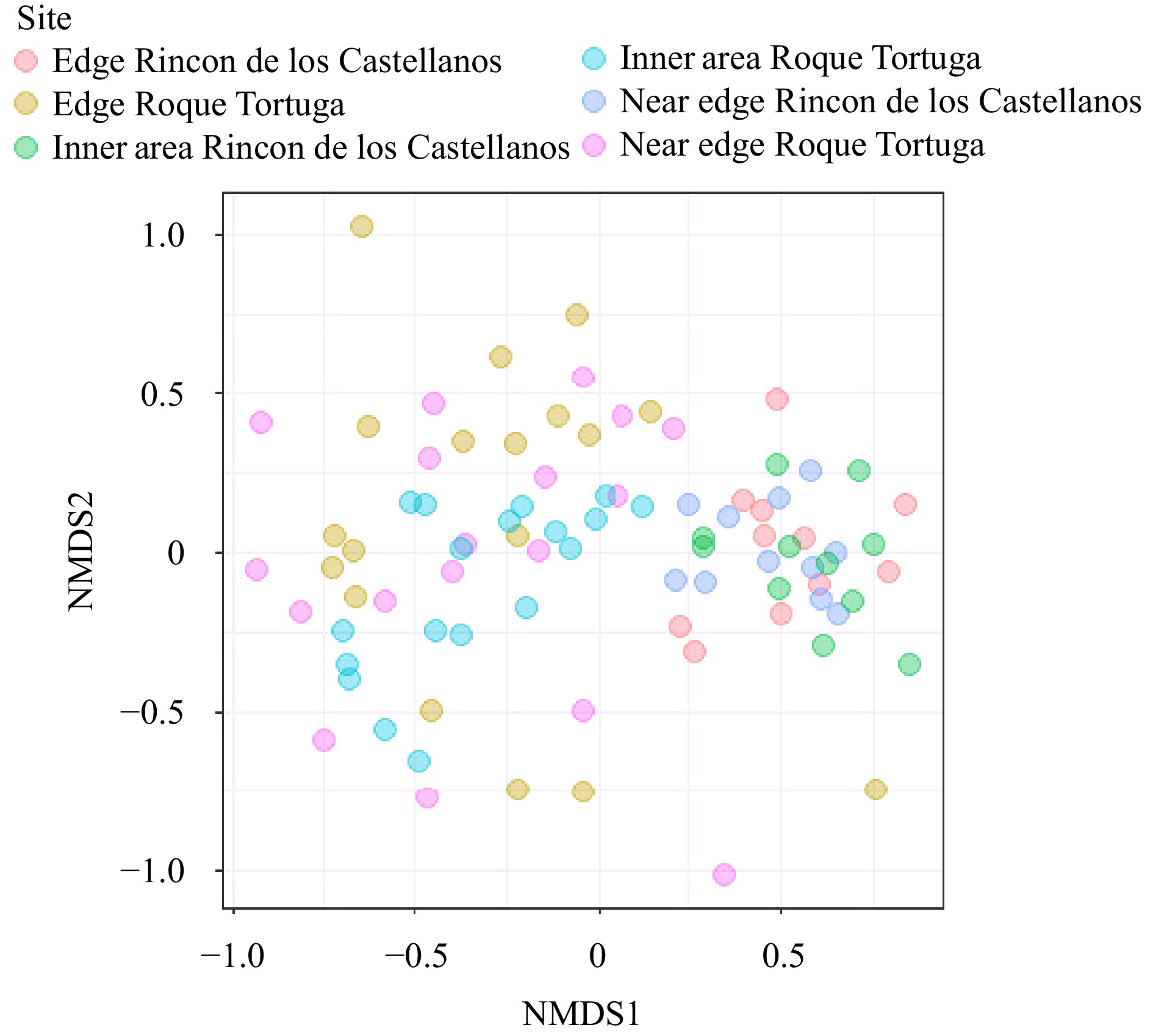
Fragmentation entails the disruption of habitat continuity, leading to anticipated species mobility as a consequence of inter-patch connectivity. Variability in species richness and individual abundances is a natural outcome in such scenarios. Our objective was to examine the edge effect within fragmented intertidal macroalgae habitats, employing the associated epifauna as a study model. This study reveals disparities in both species richness and individual abundance within the epifauna community inhabiting intertidal macroalgae during the spring season. Samples were obtained from two distinct coastal locations characterized by fragmented habitats. This enabled us to assess the distinctions in communities impacted by the edge effect as well as spatial variations. The results indicate a trend where abundance tends to be higher in the innermost regions of the patch zone in one location, while species richness remains relatively consistent across different patch zones, i.e., edge, near-edge, and inner areas by descriptive univariate analysis and ANOVA. Margalef richness and Simpson dominance are consistently higher from inner areas to edge, whilst Pielou evenness showed the contrasting trend, being higher from edge to inner areas. The patch effect seems to be a primary driver of differences among epifaunal communities. Additionally, spatial variations contribute significantly to the variability observed in these communities by the permutational multivariate analysis of variance (PERMANOVA) and non-metric multidimensional scaling (n-MDS). To gain a comprehensive understanding of the edge effect, further investigations examining other substrates, different months, or additional locations are warranted.
Fragmentation entails the disruption of habitat continuity, leading to anticipated species mobility as a consequence of inter-patch connectivity. Variability in species richness and individual abundances is a natural outcome in such scenarios. Our objective was to examine the edge effect within fragmented intertidal macroalgae habitats, employing the associated epifauna as a study model. This study reveals disparities in both species richness and individual abundance within the epifauna community inhabiting intertidal macroalgae during the spring season. Samples were obtained from two distinct coastal locations characterized by fragmented habitats. This enabled us to assess the distinctions in communities impacted by the edge effect as well as spatial variations. The results indicate a trend where abundance tends to be higher in the innermost regions of the patch zone in one location, while species richness remains relatively consistent across different patch zones, i.e., edge, near-edge, and inner areas by descriptive univariate analysis and ANOVA. Margalef richness and Simpson dominance are consistently higher from inner areas to edge, whilst Pielou evenness showed the contrasting trend, being higher from edge to inner areas. The patch effect seems to be a primary driver of differences among epifaunal communities. Additionally, spatial variations contribute significantly to the variability observed in these communities by the permutational multivariate analysis of variance (PERMANOVA) and non-metric multidimensional scaling (n-MDS). To gain a comprehensive understanding of the edge effect, further investigations examining other substrates, different months, or additional locations are warranted.


, Available online ,
doi: 10.1007/s13131-024-0001-1
Abstract:
Using literature published from 2010 onwards, this study investigates the ~3500 km extension of the shallow shelf current in the South China Sea (SCS) during the winter and summer monsoons. This current is later acknowledged as the South China Sea Shallow Shelf Current (SCSSC). This current is primarily driven by monsoonal winds, and influenced by regional river plumes (Pearl River, Hong River, Mekong River) and the prominent South China Sea Warm Current (SCSWC) and South China Sea Western Boundary Current (SCSWBC). The current exhibits significant seasonal variations in both direction and pattern. During winter, it flows along the northern South China Sea’s (NSCS) shelf and splits into two branches at the east of Hainan Island. One branch enters the Beibu-Tonkin Gulf through the Qiongzhou Strait and forms a major cyclonic circulation within the gulf, while the other branch flows southwestward along the southern coast of Hainan Island. These branches converge around 16°N latitude at the east of the Vietnamese shelf, then flow southward along the Sunda Shelf, where they deflect southwestward in “broadband” forms before curving southeastward along the east coast of Peninsular Malaysia (ECPM) and exiting via the Karimata Strait. In summer, the current exhibits a complex pattern. At the Sunda Shelf, it flows northwestward along the ECPM, then deflects northeastward around 6°N latitude, forming the Sunda Shelf’s anti-cyclonic eddy (SSE) and causing upwelling on the east coast of Peninsular Malaysia (ECPMU). Near the eastern Vietnamese shelf, the current splits around 11-12°N latitude into three distinct currents: the southward-flowing Vietnam Current, the northward-flowing Vietnam Meandering Current (VMC), and the southward-flowing SCSWBC. The VMC flows northward and then deflects northeastward south of Hainan Island, continuing northeastward along the NSCS’s shelf and exiting through the Taiwan Strait.
Using literature published from 2010 onwards, this study investigates the ~


, Available online ,
doi: 10.1007/s13131-024-2402-z
Abstract:
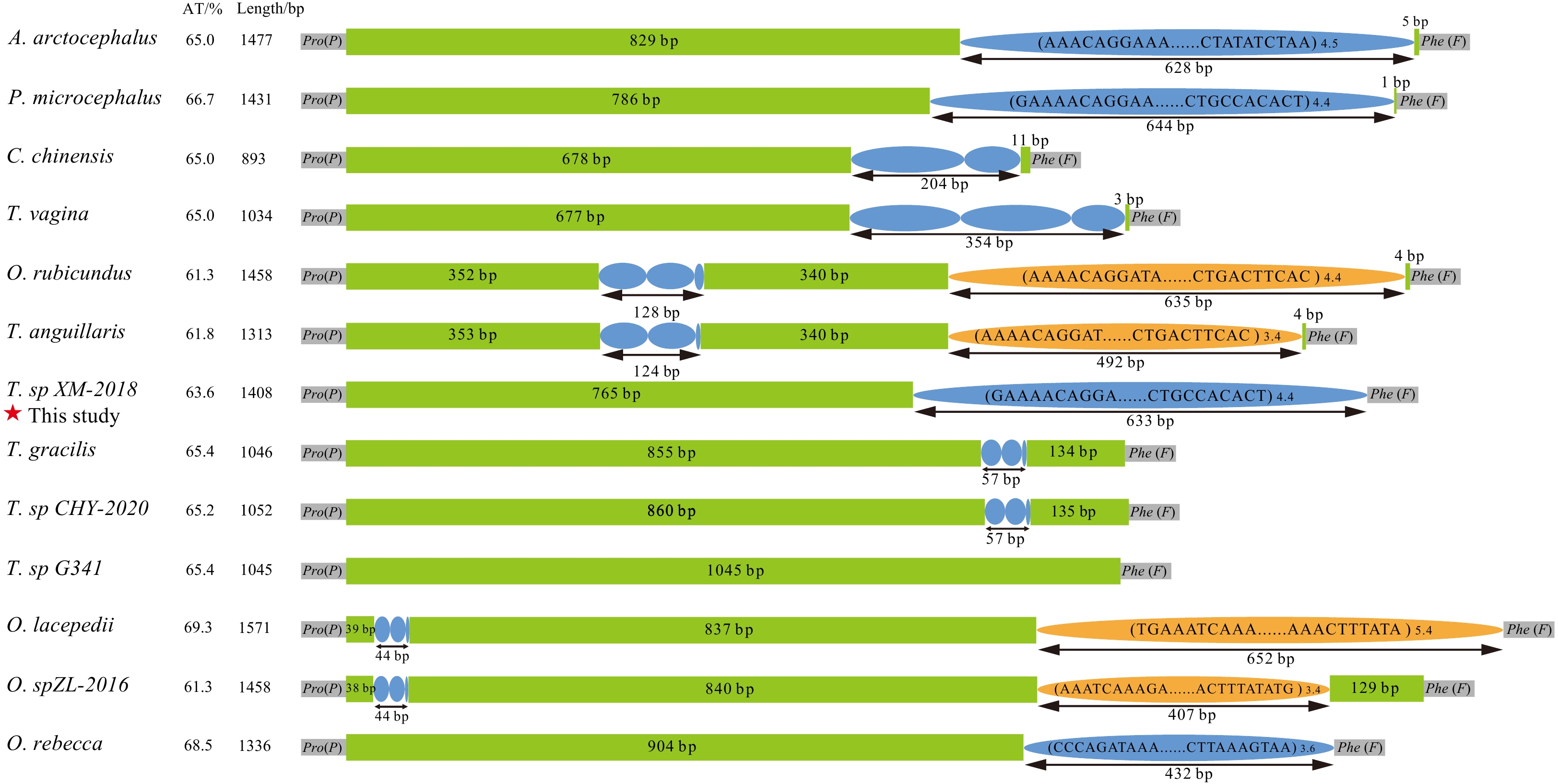
Despite most eel gobies (Gobionellidae: Amblyopinae) have inhabited brackish or marine waters, few species (such as Taenioides sp.) have been found to invade multiple inland freshwaters via artificial water transfer projects. The habitat transfers from brackish water to freshwater zones of Taenioides sp. have caused severe damage to Chinese aquatic ecosystems in recent years. Unfortunately, the molecular mechanism underlying freshwater invasion remains poorly understood. Considering changes of environment factors, especially salinity, are bound to adjust the demands for energy affected by mitochondria via oxidative phosphorylation, 13 Amblyopinae mitogenomes were compared, including the newly assembled Taenioides sp. mitogenome in this study. Comparative mitogenomic analyses revealed a highly conserved structure, composition and arrangements, with the exception of variable control region (CR). All of the CRs possessed tandem repeat sequences except Trypauchenopsis sp. G341, differing in motifs and number of copies, which was the dominant factor resulting in length heterogeneity of CR. The phylogenetic trees reconfirmed the paraphyletic origin of Amblyopinae with respect to Oxudercinae, supporting that these two subfamilies should be merged as an expansion of phenotypic variation within the “terrestrial goby” clade. Furthermore, four protein coding genes (COI, ND3, ND5 and Cyt b) in Taenioides sp. mitogenome have experienced adaptive evolution, indicating their important roles in enhancing the efficiency of ATP production to cope with the osmotic regulation adjustment and reach its current widespread distribution in multiple inland freshwaters of China. These results revealed the functional importance of mitochondrial genes, and provided fresh insights into the molecular mechanisms underlying the freshwater invasion. Also, our results may provide critical reference value for the future control of other invasive species.
Despite most eel gobies (Gobionellidae: Amblyopinae) have inhabited brackish or marine waters, few species (such as Taenioides sp.) have been found to invade multiple inland freshwaters via artificial water transfer projects. The habitat transfers from brackish water to freshwater zones of Taenioides sp. have caused severe damage to Chinese aquatic ecosystems in recent years. Unfortunately, the molecular mechanism underlying freshwater invasion remains poorly understood. Considering changes of environment factors, especially salinity, are bound to adjust the demands for energy affected by mitochondria via oxidative phosphorylation, 13 Amblyopinae mitogenomes were compared, including the newly assembled Taenioides sp. mitogenome in this study. Comparative mitogenomic analyses revealed a highly conserved structure, composition and arrangements, with the exception of variable control region (CR). All of the CRs possessed tandem repeat sequences except Trypauchenopsis sp. G341, differing in motifs and number of copies, which was the dominant factor resulting in length heterogeneity of CR. The phylogenetic trees reconfirmed the paraphyletic origin of Amblyopinae with respect to Oxudercinae, supporting that these two subfamilies should be merged as an expansion of phenotypic variation within the “terrestrial goby” clade. Furthermore, four protein coding genes (COI, ND3, ND5 and Cyt b) in Taenioides sp. mitogenome have experienced adaptive evolution, indicating their important roles in enhancing the efficiency of ATP production to cope with the osmotic regulation adjustment and reach its current widespread distribution in multiple inland freshwaters of China. These results revealed the functional importance of mitochondrial genes, and provided fresh insights into the molecular mechanisms underlying the freshwater invasion. Also, our results may provide critical reference value for the future control of other invasive species.


, Available online ,
doi: 10.1007/s13131-024-2382-z
Abstract:
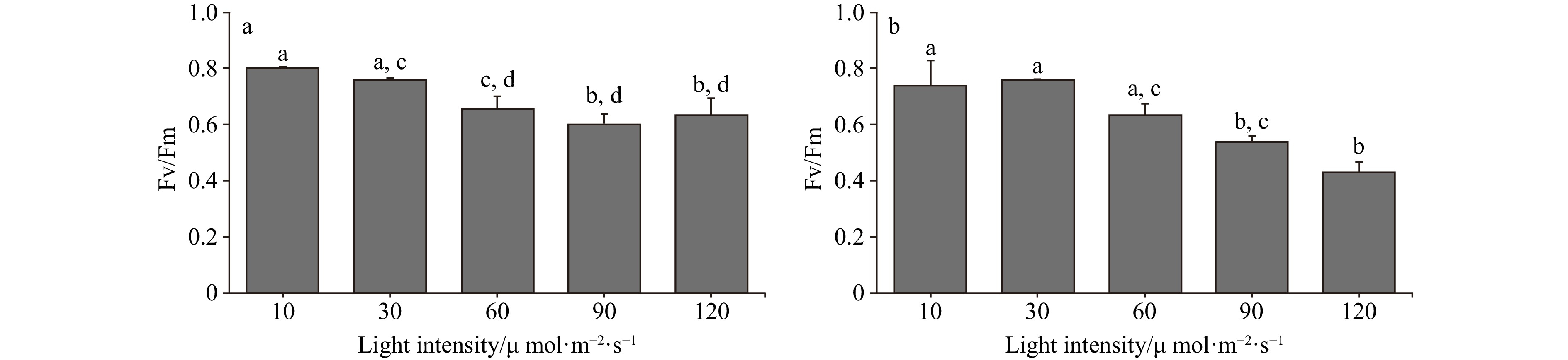
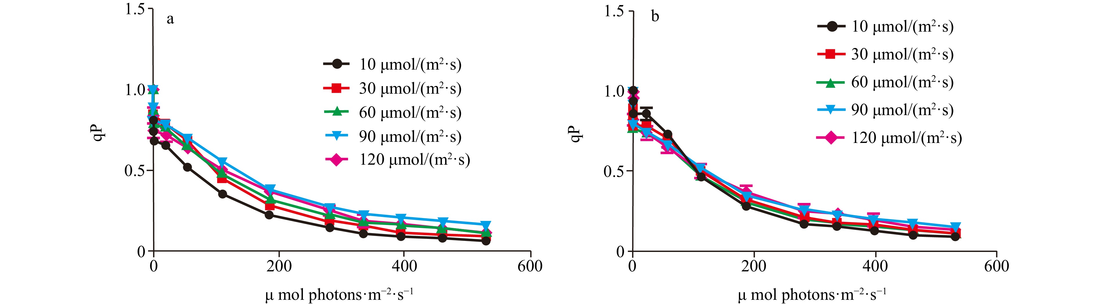
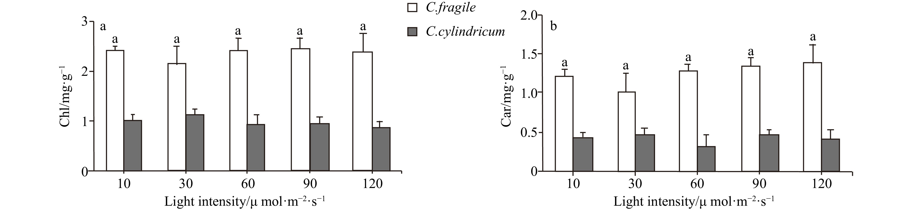
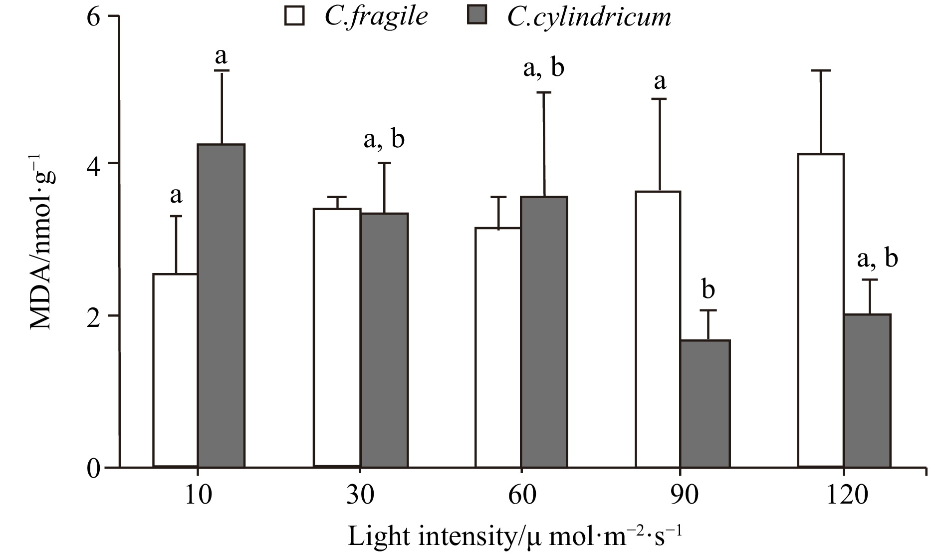
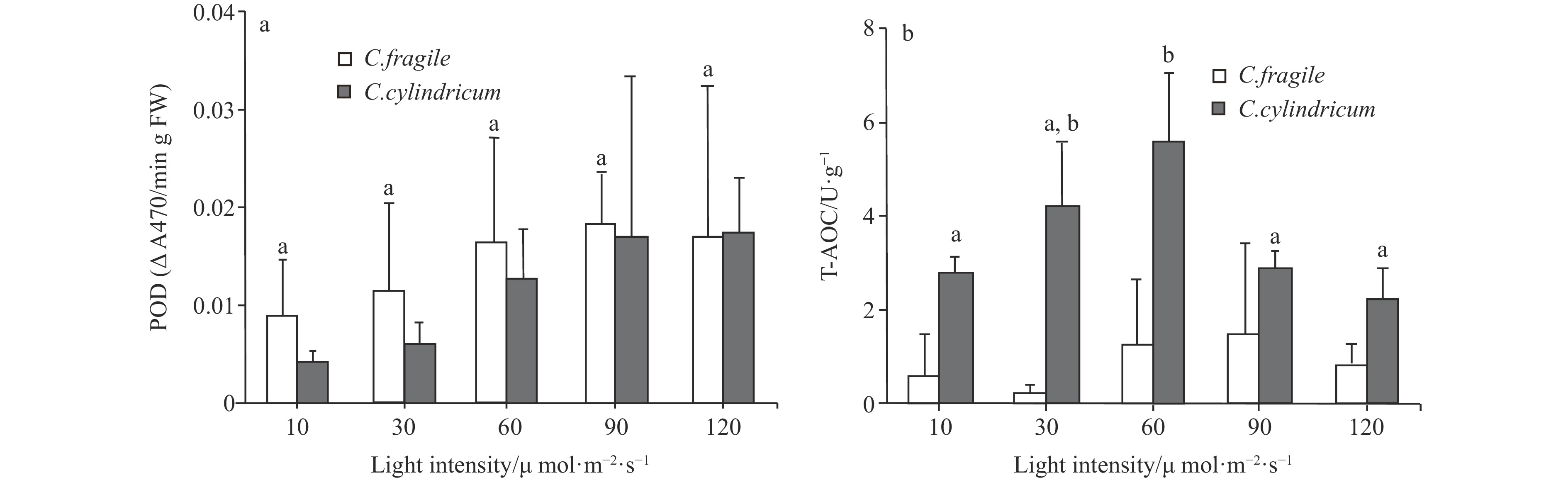
Biological invasions have become recognized as one of the greatest threats to ecosystems. Codium, a genus of invasive green algae, has frequent global outbreaks and damages local marine ecosystems. It is now generally accepted that light is one of the main factors affecting the luxuriant growth of macroalgae such as Codium. In this study, to investigate the invasive photo-adaptation strategy of Codium fragile, the photo-adaptation characteristics of C. fragile and C. cylindricum from the Nan’ ao Island of China were compared and explored. The effect of light intensity on the photosynthetic properties of the two species was investigated: the maximum quantum yield of photosystem II (Fv/Fm) of C. fragile was significantly higher at low light intensity. At a light intensity of 90 μmol/(m2·s), maximum relative electron transport rate (rETRmax) of the thalli was maximum, and the minimum saturating irradiance (Ek) was significantly increased. The photosynthetic rate (α value) of thalli was highest at a light intensity of 30 μmol/(m2·s). The photochemical quenching (qP) was enhanced but non-photochemical quenching (NPQ) was reduced at high light intensities. As for C. cylindricum, the optimal photochemical efficiency of the thalli at low light intensity was higher. High light intensity significantly reduced the rETR of the thalli. At low light intensity, α was significantly higher, Ek was significantly lower, and NPQ was also significantly decreased. The response relationship between light acclimation and antioxidant capacity of the thalli of two species of Codium was investigated: there was no significant effect of light intensity variation on the total antioxidant capacity of C. fragile. In the case of C. cylindricum, the degree of membrane lipid peroxidation was significantly increased at low light intensity, and its antioxidant capacity was significantly reduced when the light intensity was too high or too low. It can be hypothesized that the self-protection ability of C. fragile may be stronger than that of C. cylindricum under low and high light intensities, which is closely related to the strong invasiveness of C. fragile.
Biological invasions have become recognized as one of the greatest threats to ecosystems. Codium, a genus of invasive green algae, has frequent global outbreaks and damages local marine ecosystems. It is now generally accepted that light is one of the main factors affecting the luxuriant growth of macroalgae such as Codium. In this study, to investigate the invasive photo-adaptation strategy of Codium fragile, the photo-adaptation characteristics of C. fragile and C. cylindricum from the Nan’ ao Island of China were compared and explored. The effect of light intensity on the photosynthetic properties of the two species was investigated: the maximum quantum yield of photosystem II (Fv/Fm) of C. fragile was significantly higher at low light intensity. At a light intensity of 90 μmol/(m2·s), maximum relative electron transport rate (rETRmax) of the thalli was maximum, and the minimum saturating irradiance (Ek) was significantly increased. The photosynthetic rate (α value) of thalli was highest at a light intensity of 30 μmol/(m2·s). The photochemical quenching (qP) was enhanced but non-photochemical quenching (NPQ) was reduced at high light intensities. As for C. cylindricum, the optimal photochemical efficiency of the thalli at low light intensity was higher. High light intensity significantly reduced the rETR of the thalli. At low light intensity, α was significantly higher, Ek was significantly lower, and NPQ was also significantly decreased. The response relationship between light acclimation and antioxidant capacity of the thalli of two species of Codium was investigated: there was no significant effect of light intensity variation on the total antioxidant capacity of C. fragile. In the case of C. cylindricum, the degree of membrane lipid peroxidation was significantly increased at low light intensity, and its antioxidant capacity was significantly reduced when the light intensity was too high or too low. It can be hypothesized that the self-protection ability of C. fragile may be stronger than that of C. cylindricum under low and high light intensities, which is closely related to the strong invasiveness of C. fragile.


, Available online ,
doi: 10.1007/s13131-024-2391-y
Abstract:
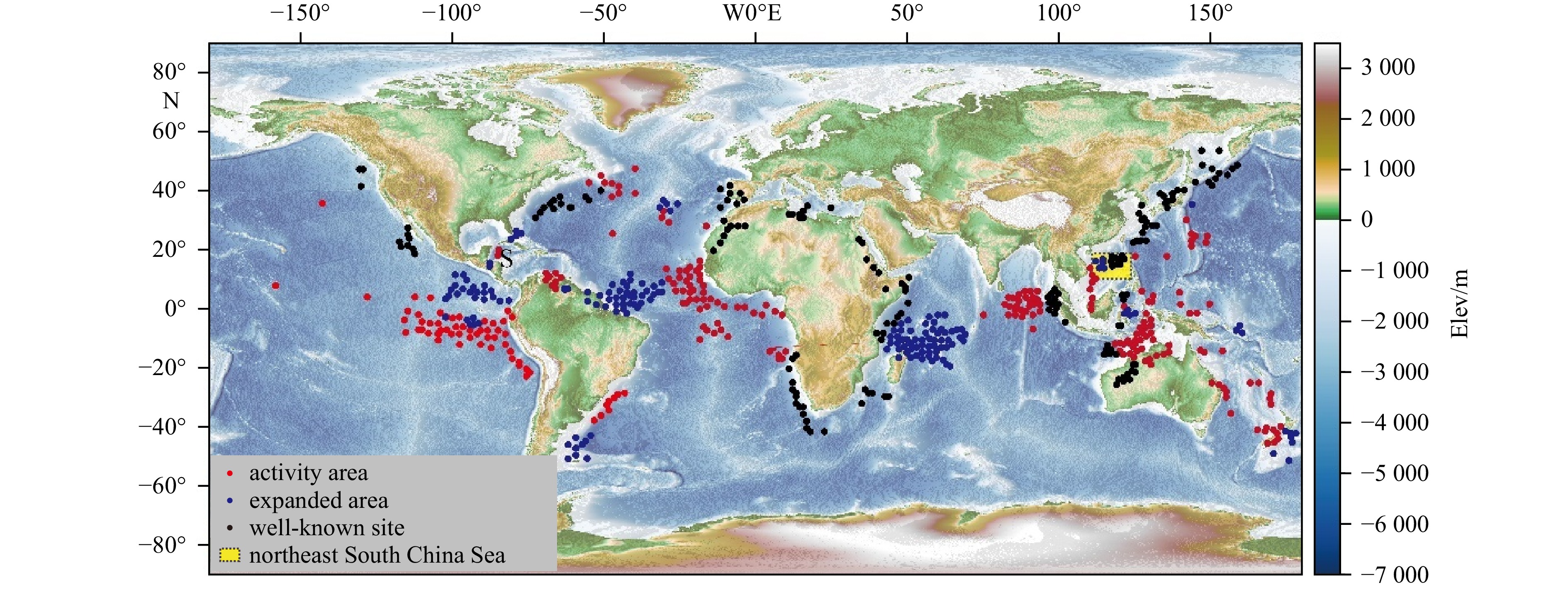
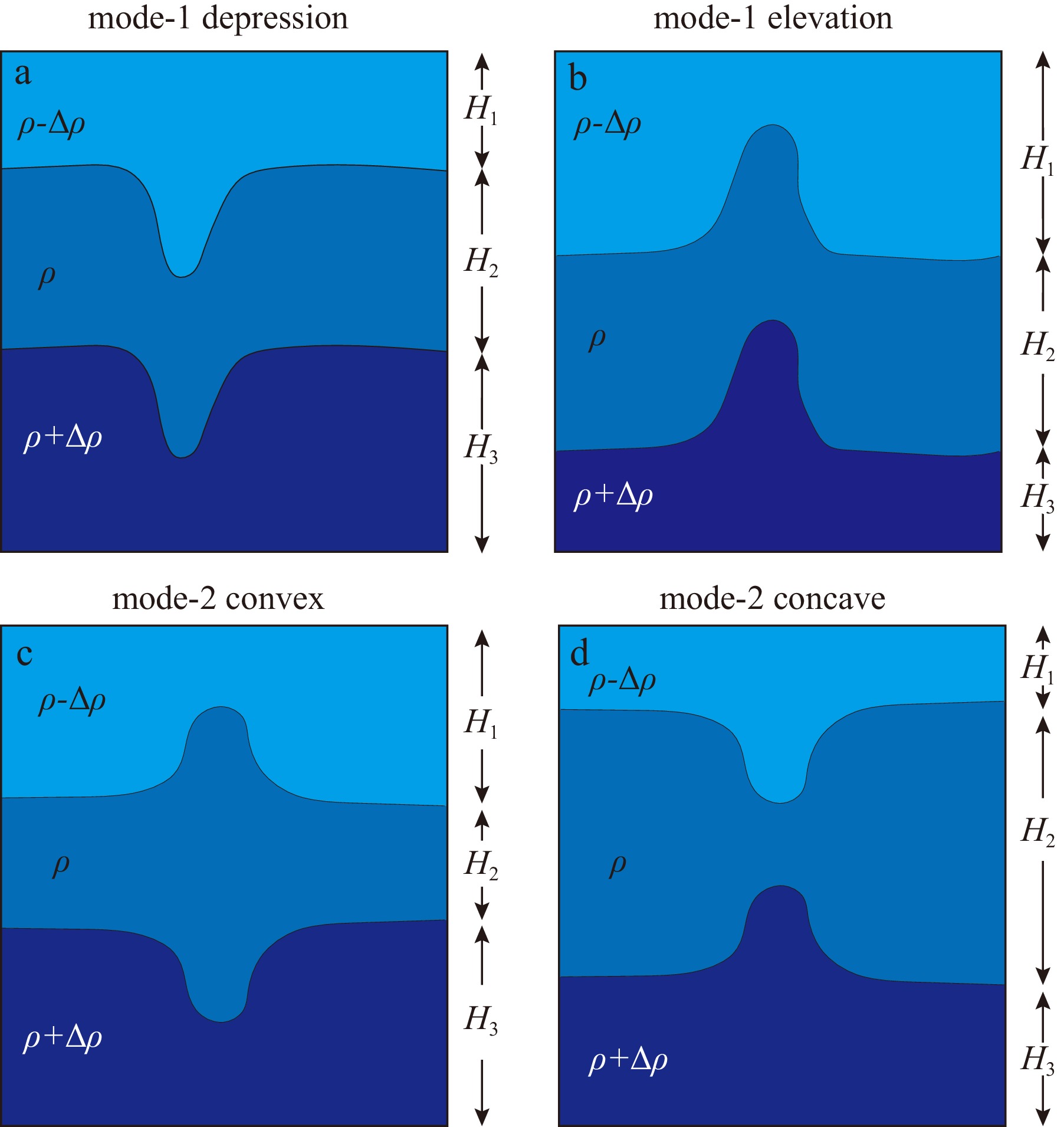
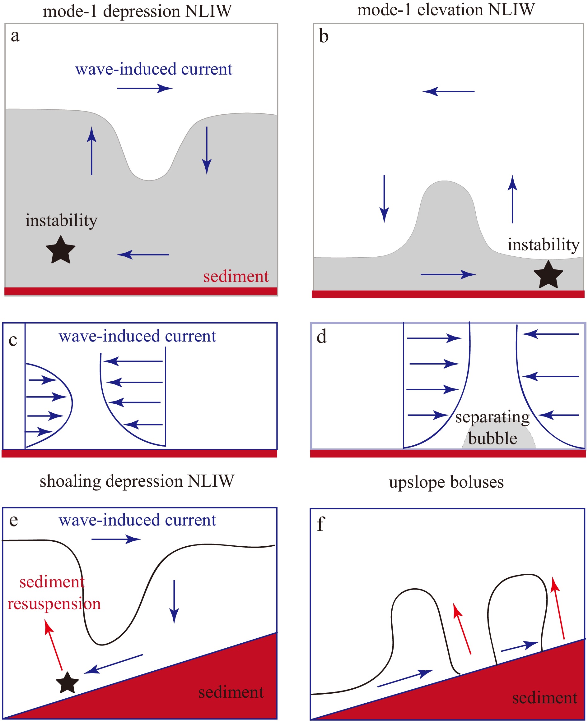
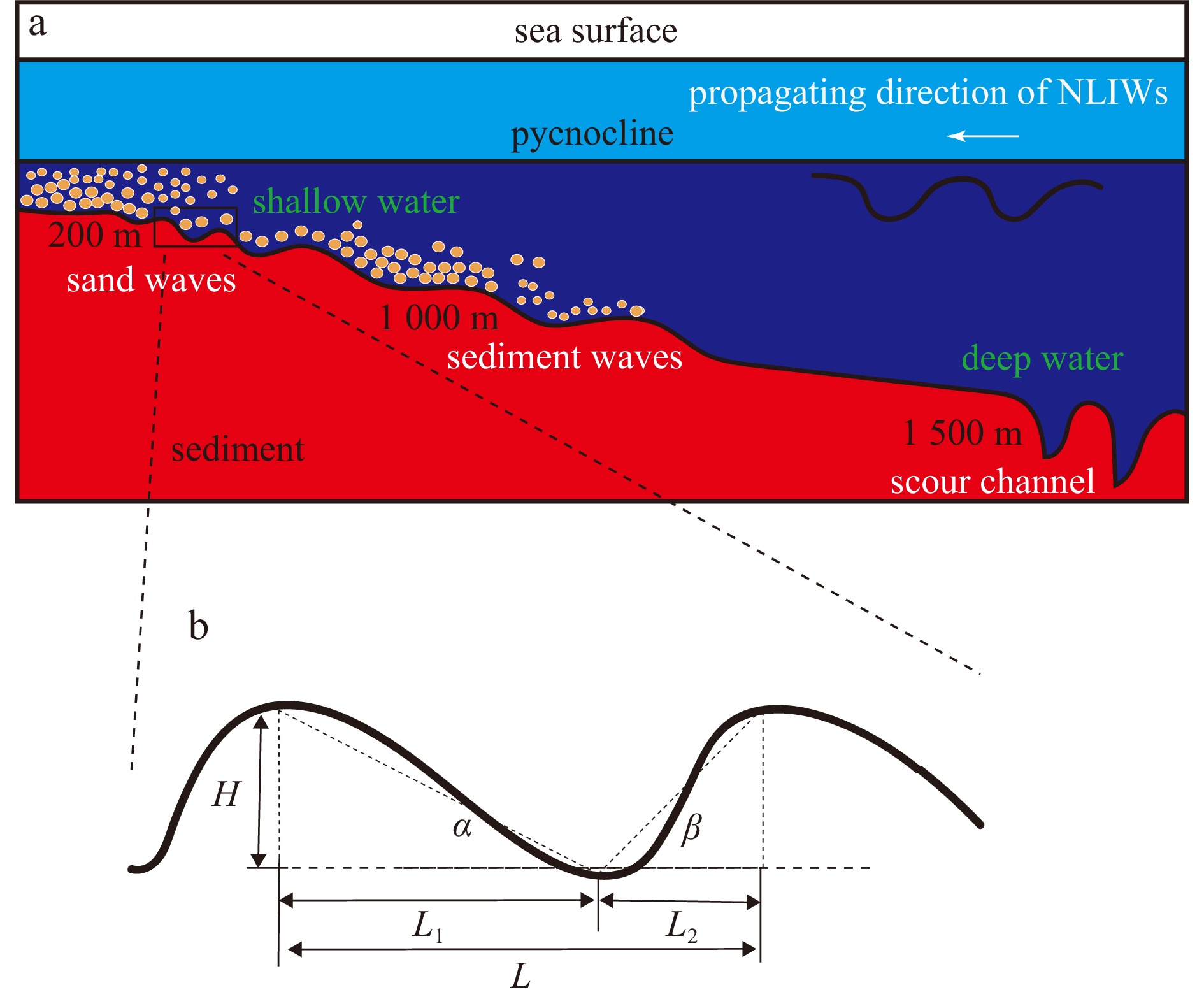
Nonlinear internal waves (NLIWs) exhibit robust dynamic submesoscale motions, connecting large-scale tides to small-scale shear instabilities in the ocean. Previous studies have mainly focused on their generation mechanisms and evolution along their paths. Considering their global distribution resulting from the primary origin in tide-topography interaction, there is an increasing cross-disciplinary interest in understanding how these energetic and ubiquitous NLIWs contribute to sediment redistribution in the ocean. This paper presents fundamental theories on NLIWs and comprehensively reviews triggering mechanisms, different types of instability, and sediment responses by summarizing recent theoretical parameterizations, numerical simulations, laboratory experiments, and in-situ observations. We specifically focus on elucidating various types of instability along with their impact on sediment dynamic processes. Finally, we outline several unresolved issues that require further exploration for a quantitative investigation into NLIW-induced sediment transfer in the ocean.
Nonlinear internal waves (NLIWs) exhibit robust dynamic submesoscale motions, connecting large-scale tides to small-scale shear instabilities in the ocean. Previous studies have mainly focused on their generation mechanisms and evolution along their paths. Considering their global distribution resulting from the primary origin in tide-topography interaction, there is an increasing cross-disciplinary interest in understanding how these energetic and ubiquitous NLIWs contribute to sediment redistribution in the ocean. This paper presents fundamental theories on NLIWs and comprehensively reviews triggering mechanisms, different types of instability, and sediment responses by summarizing recent theoretical parameterizations, numerical simulations, laboratory experiments, and in-situ observations. We specifically focus on elucidating various types of instability along with their impact on sediment dynamic processes. Finally, we outline several unresolved issues that require further exploration for a quantitative investigation into NLIW-induced sediment transfer in the ocean.


, Available online ,
doi: 10.1007/s13131-020-0000-9
Abstract:
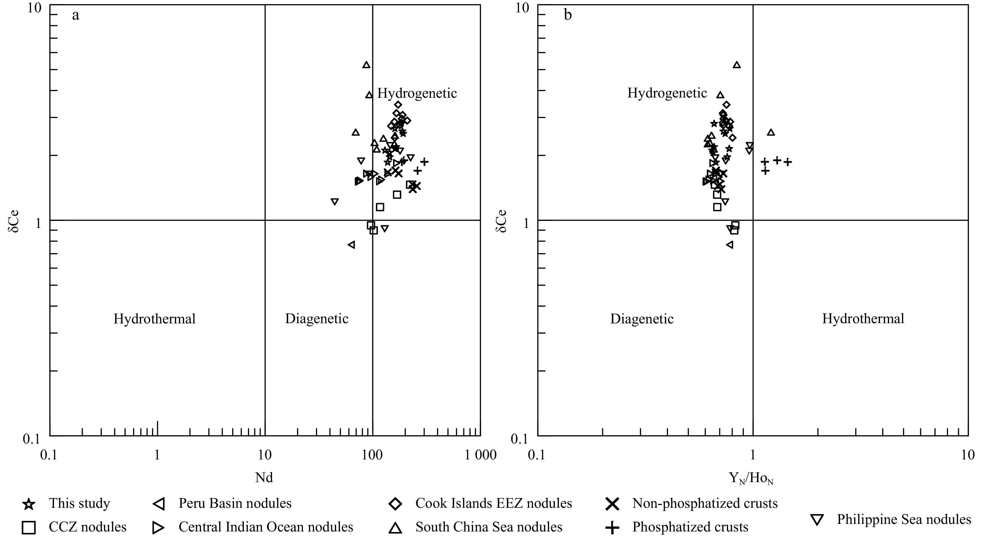
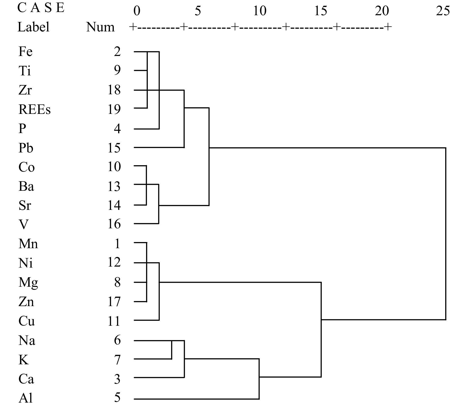
To explore the geochemical characteristics and genesis of the elements in ferromanganese nodules from the Northwest Pacific, this study analyses the mineral composition, elemental content, occurrence phase and genetic mechanisms of samples by X-ray diffraction (XRD), inductively coupled plasma‒optical emission spectrometry (ICP-OES), inductively coupled plasma‒mass spectrometry (ICP-MS) and phase analysis methods. The results show that ferromanganese nodules are mainly hydrogenetic, and Mn/Fe ratio ranges from 0.95 to 2.05. The major minerals are vernadite (δ-MnO2) and amorphous ferric oxyhydroxide (FeOOH), and the secondary minerals include todorokite, birnessite, quartz and plagioclase. Ferromanganese nodules contain high contents of Co (0.24%~0.42%), Cu (0.23%~0.73%), Ni (0.33%~0.86%) and rare earth elements (REEs,1192 µg/g~1990 µg/g), which have positive Ce and negative Y anomalies but no Eu anomaly. A cluster analysis suggests that the elements in ferromanganese nodules can be divided into three groups: hydrogenetic components, including Fe, Ti, Zr, P, Pb, Co, Ba, Sr, V and REEs; diagenetic components, including Mn, Ni, Mg, Zn and Cu; and detrital components, including Al, Na, K and Ca. According to chemical leaching, ferromanganese nodules can be divided into four phases: Na, Ca, Mg and Sr are mainly enriched in the carbonate phase; Mn, Co, Ni and Ba are mainly enriched in the Mn-oxide phase; Fe, P, Ti, Cu, Pb, V, Zn, Zr and REEs are mainly enriched in the Fe-oxide phase; and Al and K are mainly enriched in the residual phase. A combination of the two different methods reveal selective enrichment of metal elements from seawater by ferromanganese nodules, featuring multisource mineralization. Moreover, through ion exchange and adsorption, approximately 71.2% of REEs are enriched in the Fe-oxide phase, 15.4% in the Mn-oxide phase and 12.4% in the residual phase, while REE contents in the carbonate phase are relatively low. In addition, under the oxic conditions of seawater, the oxidation of soluble Ce3+ to insoluble CeO2 together with Fe-Mn minerals results in Ce enrichment in ferromanganese nodules. This study provides a reference for the metallogenesis of ferromanganese nodules from the Northwest Pacific.
To explore the geochemical characteristics and genesis of the elements in ferromanganese nodules from the Northwest Pacific, this study analyses the mineral composition, elemental content, occurrence phase and genetic mechanisms of samples by X-ray diffraction (XRD), inductively coupled plasma‒optical emission spectrometry (ICP-OES), inductively coupled plasma‒mass spectrometry (ICP-MS) and phase analysis methods. The results show that ferromanganese nodules are mainly hydrogenetic, and Mn/Fe ratio ranges from 0.95 to 2.05. The major minerals are vernadite (δ-MnO2) and amorphous ferric oxyhydroxide (FeOOH), and the secondary minerals include todorokite, birnessite, quartz and plagioclase. Ferromanganese nodules contain high contents of Co (0.24%~0.42%), Cu (0.23%~0.73%), Ni (0.33%~0.86%) and rare earth elements (REEs,


, Available online ,
doi: 10.1007/s13131-020-0000-0
Abstract:
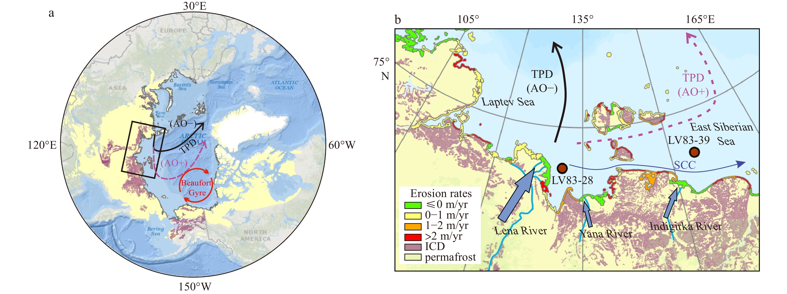
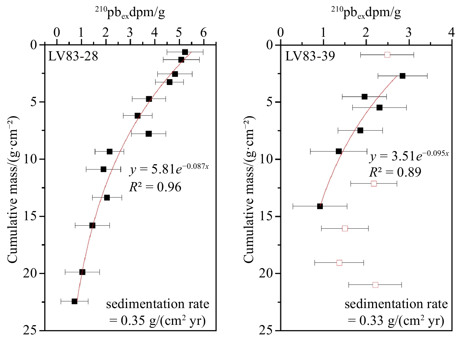
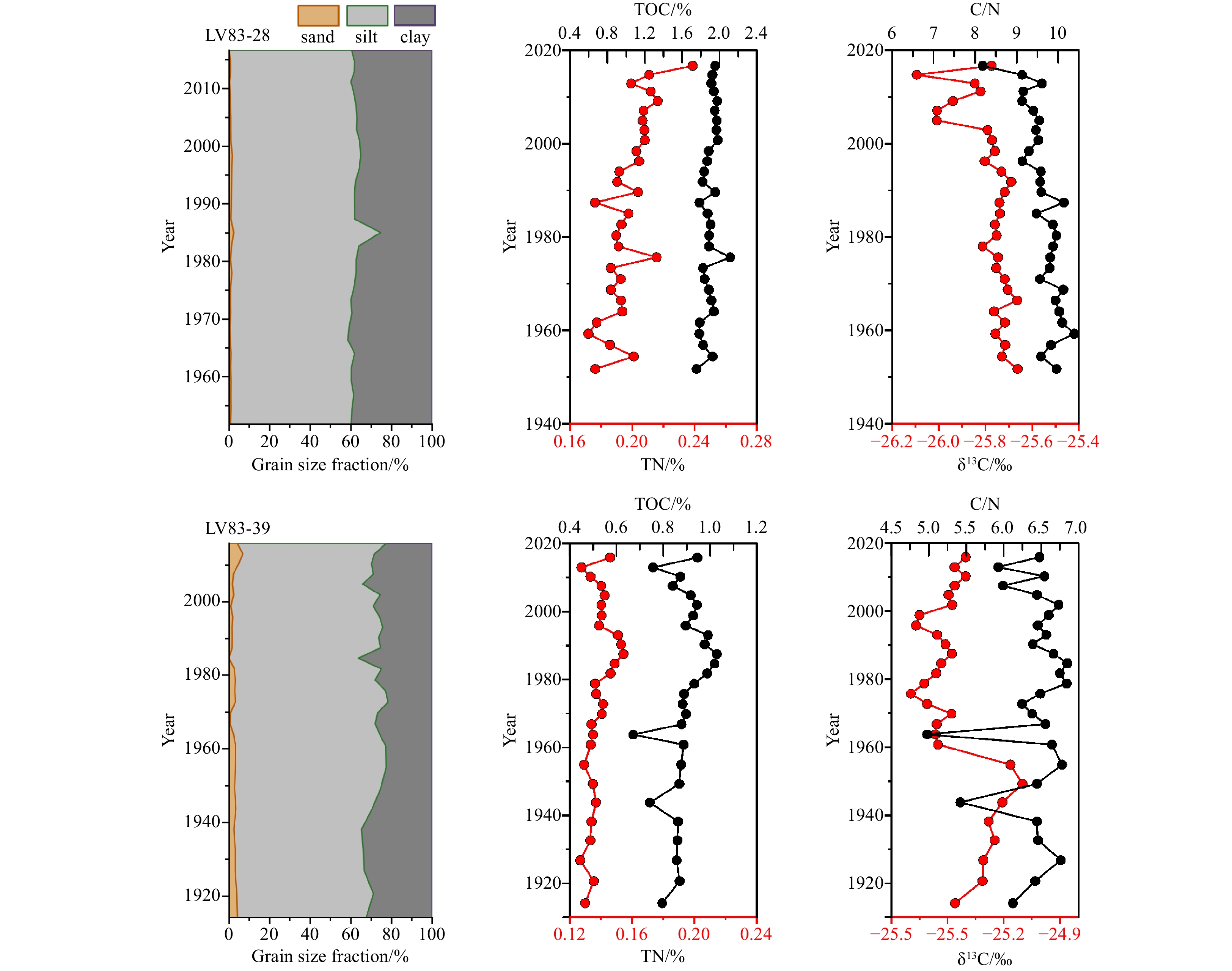
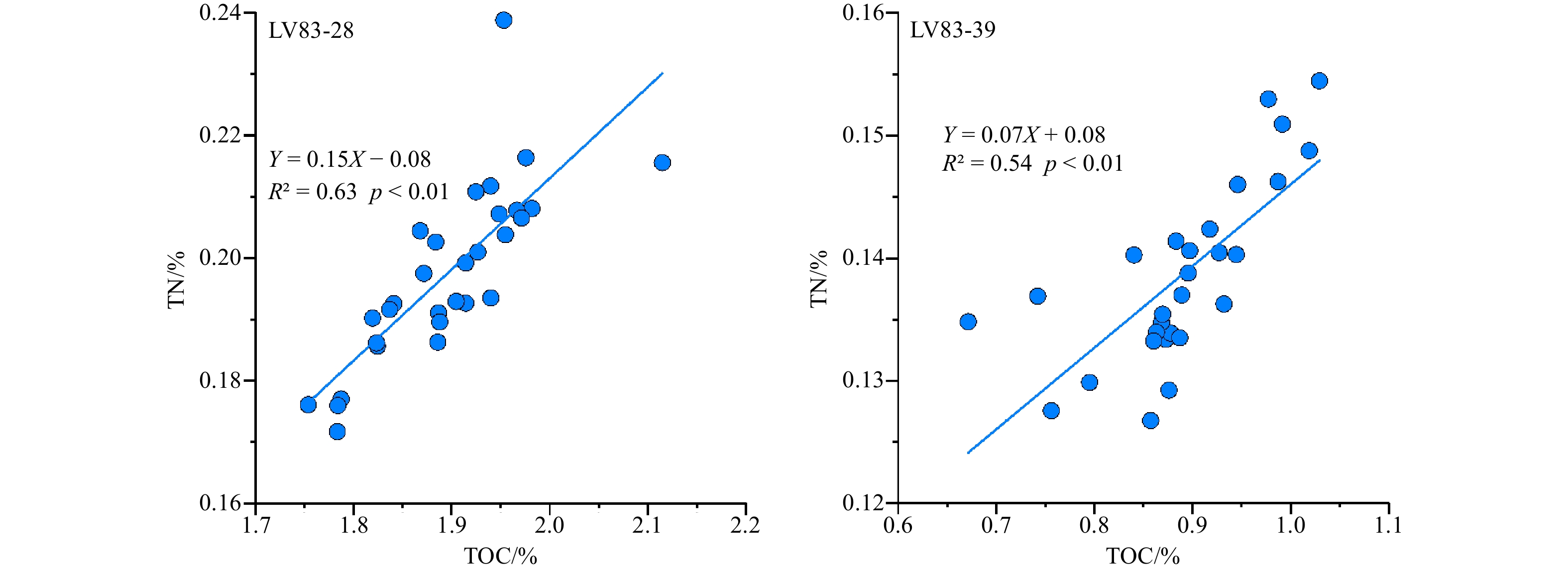
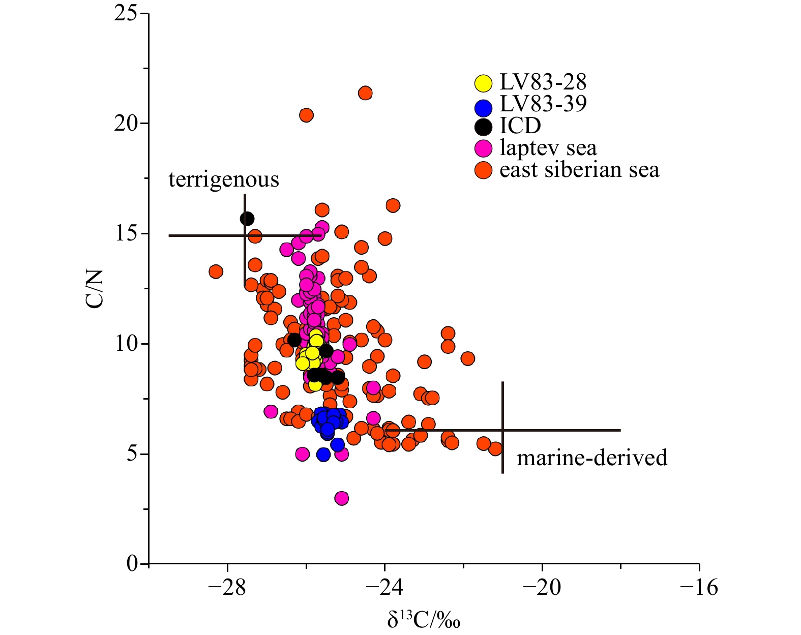
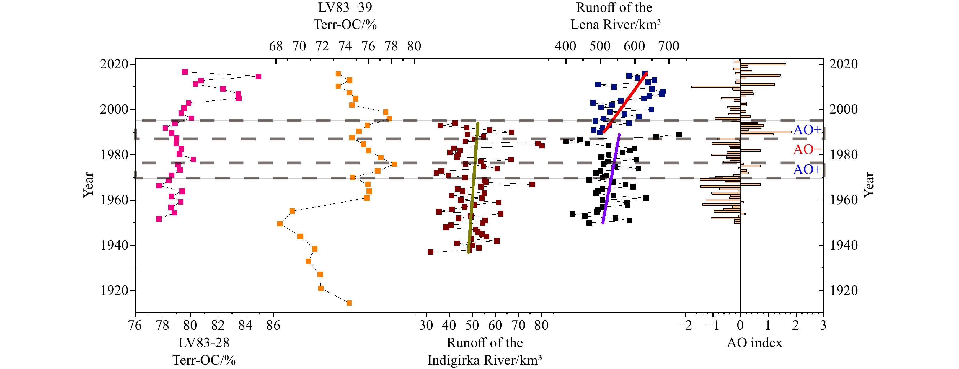
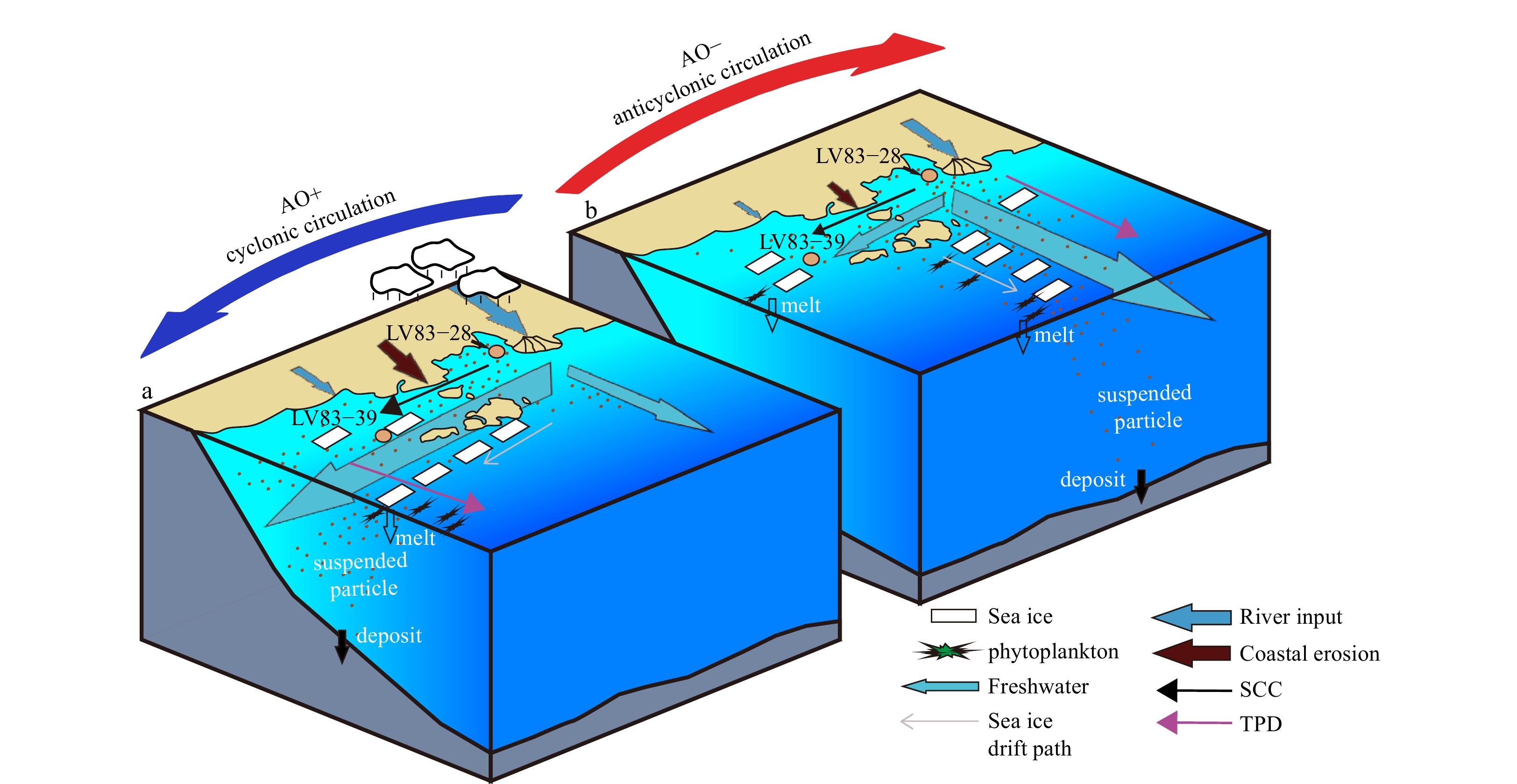
Arctic climate changes have profoundly influenced the polar environmental changes in recent years. Arctic Oscillation (AO), as a key component of the Arctic climate system’s internal variability, affects the source to sink processes and interactions across the multilayer Arctic system by regulating the land, ocean, sea ice, and atmospheric processes. The East Siberian Arctic Shelf (ESAS) has experienced significant changes in the input, transport, and burial of sedimentary organic carbon (OC) due to climate warming and shifts in the AO phase in recent decades. This study analyzes grain size, total organic carbon (TOC), total nitrogen (TN), and stable carbon isotope (δ13C) in two sediment cores from the ESAS to reconstruct the burial record of OC over the past few decades and examine the response mechanism of sedimentary OC records to regional-scale climate forcing. The results show that the OC in the two sediment cores originates from mixed sources with a dominant terrestrial contribution. In the LV83-28 core from the Laptev Sea, the TOC and TN content have increased at an accelerated rate since the 1990s, with a noticeable rise in the contribution of terrestrial OC. This trend is linked to an increase in terrigenous input caused by the positive AO phase. Core LV83-39 in the East Siberian Sea could have accumulated more terrestrial OC transported along the continental shelf during the positive AO. This implies that, under the interannual regulation of the AO regime, the input and cross-shelf transport of terrigenous OC in the ESAS showed consistent sedimentary responses. This finding could enhance the understanding of the burial mechanism of sedimentary OC and its environmental response to regional climate change.
Arctic climate changes have profoundly influenced the polar environmental changes in recent years. Arctic Oscillation (AO), as a key component of the Arctic climate system’s internal variability, affects the source to sink processes and interactions across the multilayer Arctic system by regulating the land, ocean, sea ice, and atmospheric processes. The East Siberian Arctic Shelf (ESAS) has experienced significant changes in the input, transport, and burial of sedimentary organic carbon (OC) due to climate warming and shifts in the AO phase in recent decades. This study analyzes grain size, total organic carbon (TOC), total nitrogen (TN), and stable carbon isotope (δ13C) in two sediment cores from the ESAS to reconstruct the burial record of OC over the past few decades and examine the response mechanism of sedimentary OC records to regional-scale climate forcing. The results show that the OC in the two sediment cores originates from mixed sources with a dominant terrestrial contribution. In the LV83-28 core from the Laptev Sea, the TOC and TN content have increased at an accelerated rate since the 1990s, with a noticeable rise in the contribution of terrestrial OC. This trend is linked to an increase in terrigenous input caused by the positive AO phase. Core LV83-39 in the East Siberian Sea could have accumulated more terrestrial OC transported along the continental shelf during the positive AO. This implies that, under the interannual regulation of the AO regime, the input and cross-shelf transport of terrigenous OC in the ESAS showed consistent sedimentary responses. This finding could enhance the understanding of the burial mechanism of sedimentary OC and its environmental response to regional climate change.
, Available online ,
doi: 10.1007/s13131-024-2399-3
Abstract:
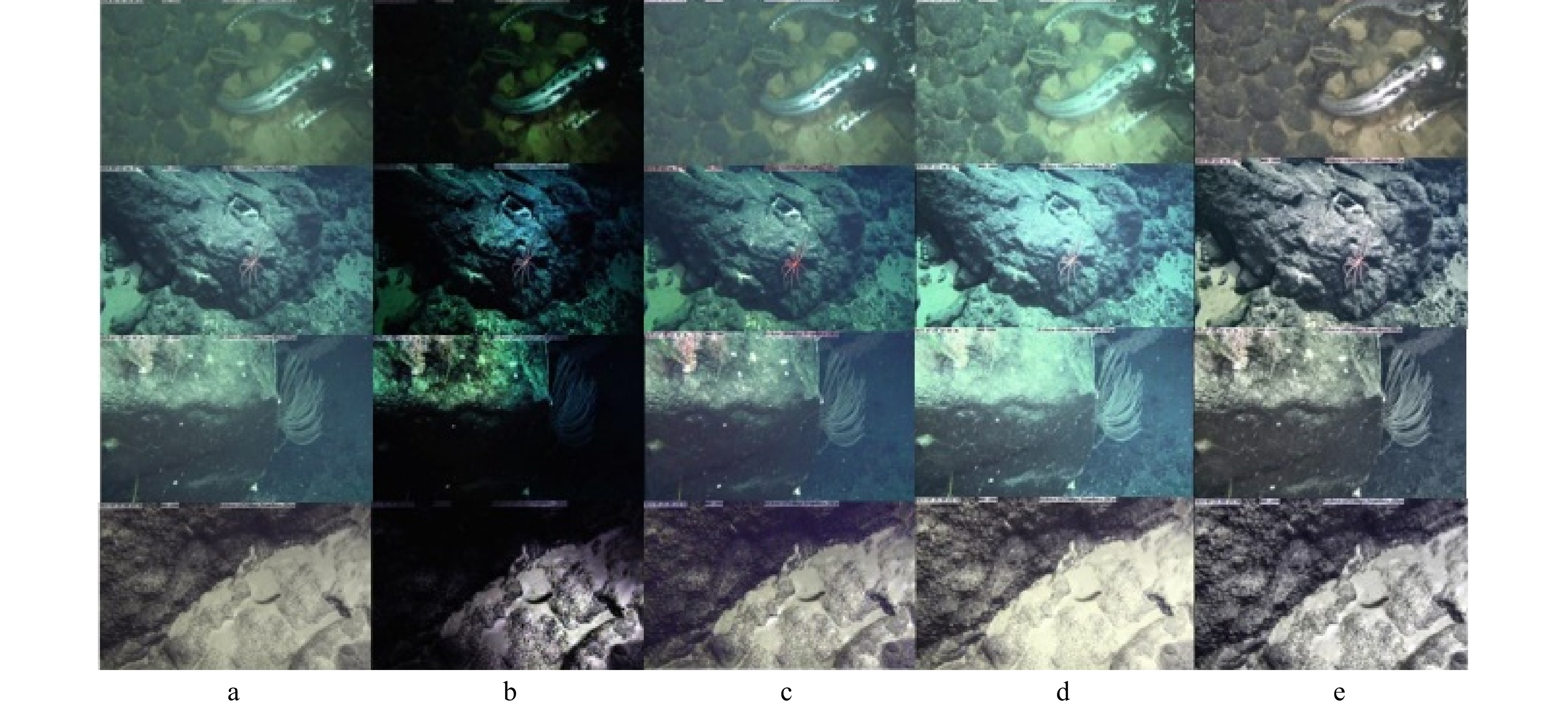
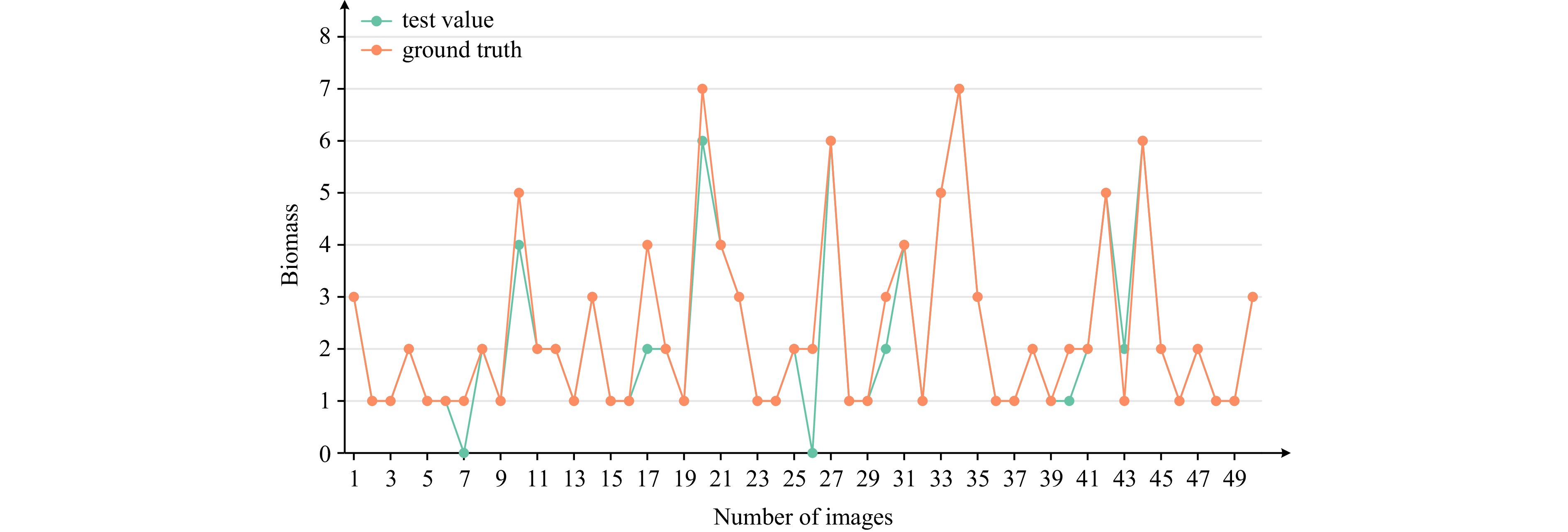
Scientific and precise evaluations of the megafaunal and landform characteristics of seamounts are important guides for their protection and study. A series of manned and unmanned submersibles have provided invaluable observational imaging data for the ecological study of seamounts. However, traditional methods of artificial observation of seamount imaging data cannot accurately and efficiently determine the characteristics of megafauna and landforms. This research harnesses data-driven technology to systematically investigate the distributional traits and morphological features of megafaunal organisms, as well as the topographical characteristics, in the Caiwei Guyot region of the western Pacific's Magellan Seamounts. To construct the landform and megafauna dataset of the Caiwei Guyot region, we used a data preprocessing technology based on image enhancement to provide high-quality imaging data for data-driven technologies. A megafaunal identification and counting algorithm based on YOLOv5 (You Only Look Once Version 5) was developed to efficiently assess the abundance, variety, and dominant species of megafauna. Simultaneously, a landform three-dimensional (3D) reconstruction algorithm based on PatchmatchNet was developed to reconstruct the 3D form of the terrain accurately. This study pioneers the application of data-driven technology to deep-sea imaging within the Caiwei Guyot region, offering an innovative approach to accurately and efficiently characterize the region's unique megafauna and landforms.
Scientific and precise evaluations of the megafaunal and landform characteristics of seamounts are important guides for their protection and study. A series of manned and unmanned submersibles have provided invaluable observational imaging data for the ecological study of seamounts. However, traditional methods of artificial observation of seamount imaging data cannot accurately and efficiently determine the characteristics of megafauna and landforms. This research harnesses data-driven technology to systematically investigate the distributional traits and morphological features of megafaunal organisms, as well as the topographical characteristics, in the Caiwei Guyot region of the western Pacific's Magellan Seamounts. To construct the landform and megafauna dataset of the Caiwei Guyot region, we used a data preprocessing technology based on image enhancement to provide high-quality imaging data for data-driven technologies. A megafaunal identification and counting algorithm based on YOLOv5 (You Only Look Once Version 5) was developed to efficiently assess the abundance, variety, and dominant species of megafauna. Simultaneously, a landform three-dimensional (3D) reconstruction algorithm based on PatchmatchNet was developed to reconstruct the 3D form of the terrain accurately. This study pioneers the application of data-driven technology to deep-sea imaging within the Caiwei Guyot region, offering an innovative approach to accurately and efficiently characterize the region's unique megafauna and landforms.


, Available online ,
doi: 10.1007/s13131-024-2393-9
Abstract:
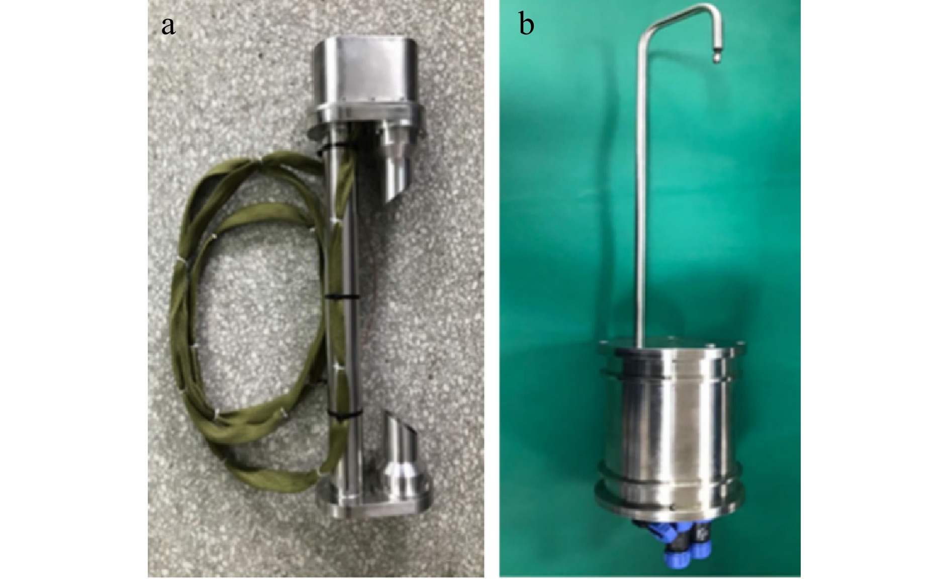
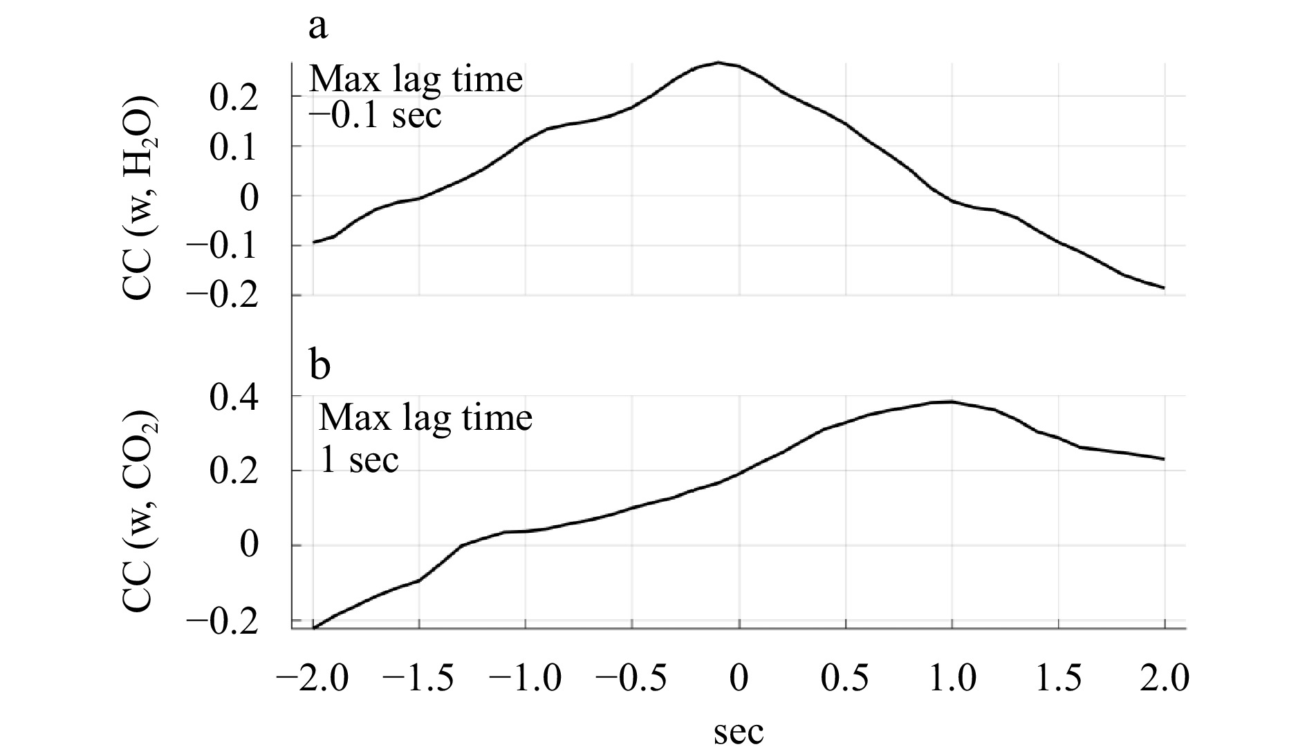
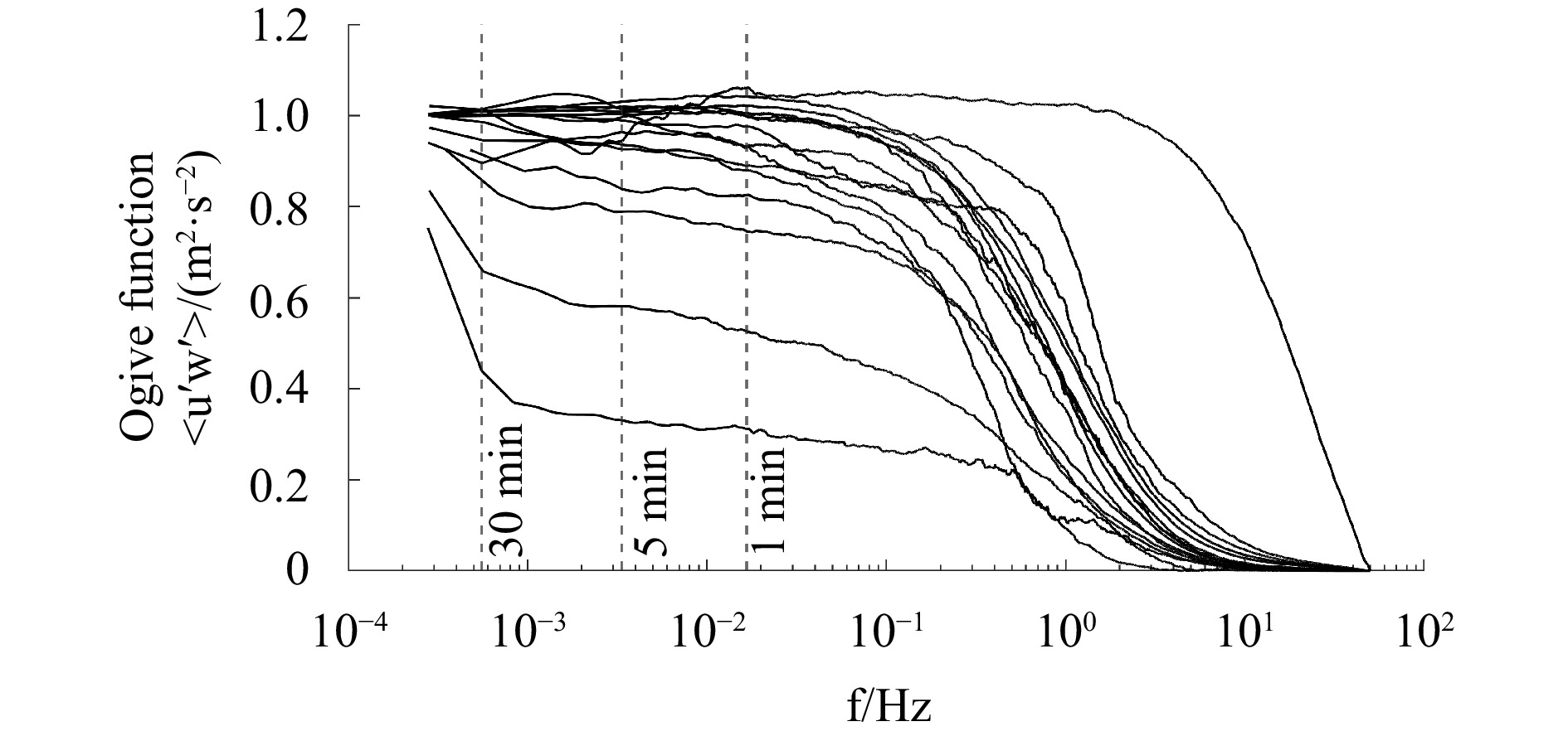
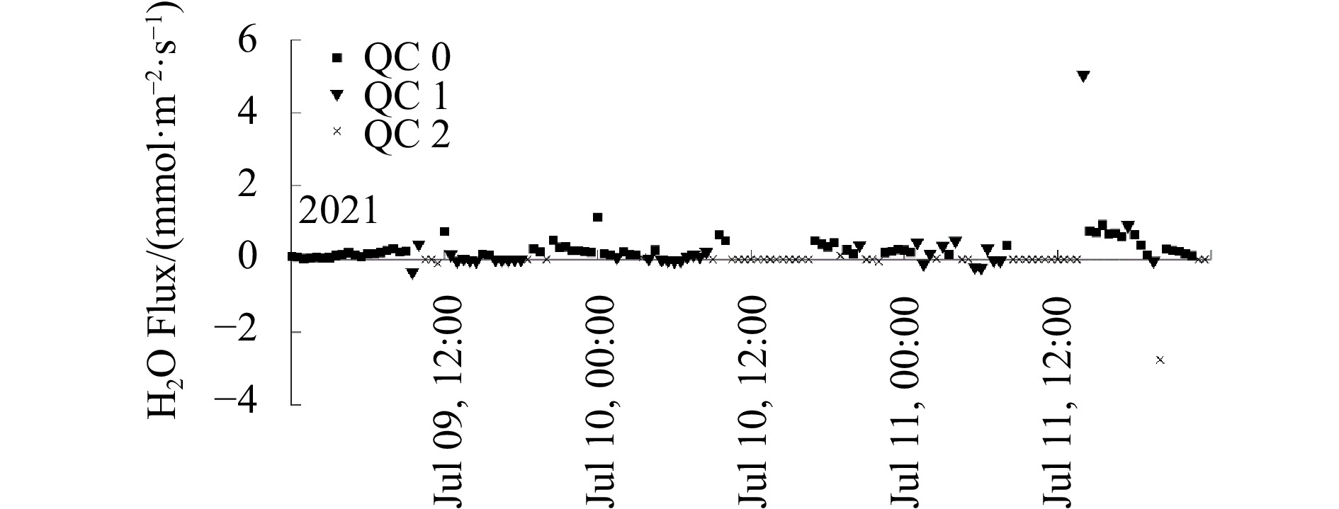
Air-sea water vapor and CO2 flux observation experiments were carried out at the Yantai National Satellite Ocean Calibration Platform and the jetty at Monolithic Beach, Juehua Island, using a 100 Hz gas analyzer. The observations were corrected by employing wild point rejection, linear detrending, delay correction, coordinate rotation, time matching, and WPL correction. The results of spectral analysis and a turbulence development adequacy data quality check showed that the overall observation data quality was good. The air-sea water vapor and CO2 flux results showed that the observation duration affected both the air-sea flux intensity and direction at different observation frequencies. At shorter observation durations, the air-sea flux values measured at 100 Hz were smaller than the 20 Hz measurements and had opposite directions. In addition, the WPL correction reduced the overall air-sea flux and partially minimized the effect of observation frequency on the air-sea flux intensity. These results showed that high-frequency observations showed more turbulence variations than low-frequency observations. This conclusion could promote an understanding of small-scale turbulence variations.
Air-sea water vapor and CO2 flux observation experiments were carried out at the Yantai National Satellite Ocean Calibration Platform and the jetty at Monolithic Beach, Juehua Island, using a 100 Hz gas analyzer. The observations were corrected by employing wild point rejection, linear detrending, delay correction, coordinate rotation, time matching, and WPL correction. The results of spectral analysis and a turbulence development adequacy data quality check showed that the overall observation data quality was good. The air-sea water vapor and CO2 flux results showed that the observation duration affected both the air-sea flux intensity and direction at different observation frequencies. At shorter observation durations, the air-sea flux values measured at 100 Hz were smaller than the 20 Hz measurements and had opposite directions. In addition, the WPL correction reduced the overall air-sea flux and partially minimized the effect of observation frequency on the air-sea flux intensity. These results showed that high-frequency observations showed more turbulence variations than low-frequency observations. This conclusion could promote an understanding of small-scale turbulence variations.


, Available online ,
doi: 10.1007/s13131-024-2369-9
Abstract:
Microsatellite markers with polymorphic advantages are widely used in the exploration and utilization of marine fishery resources. In this study, 16 polymorphic microsatellite markers were used to evaluate the diversity and population structure of Setipinna tenuifilis, a nearshore fish of economic and ecological value in the western Pacific and Indian Oceans. The genetic diversity of S. tenuifilis showed a high level (mean Na=23.25, mean Ho=0.639, mean Ra=11.625, and PIC=0.844) similar to other Clupeiformes fish species. The nine wild S. tenuifilis populations showed significant differentiation (FST ranging from0.00384 to 0.19346 ) and were generally divided into southern and northern populations based on genetic structure, except for the Zhoushan population, which exhibited genetic mixture. Our results provide fundamental but significant genetic insights for the management and conservation of S. tenuifilis fishery resources.
Microsatellite markers with polymorphic advantages are widely used in the exploration and utilization of marine fishery resources. In this study, 16 polymorphic microsatellite markers were used to evaluate the diversity and population structure of Setipinna tenuifilis, a nearshore fish of economic and ecological value in the western Pacific and Indian Oceans. The genetic diversity of S. tenuifilis showed a high level (mean Na=23.25, mean Ho=0.639, mean Ra=11.625, and PIC=0.844) similar to other Clupeiformes fish species. The nine wild S. tenuifilis populations showed significant differentiation (FST ranging from


, Available online
Abstract:
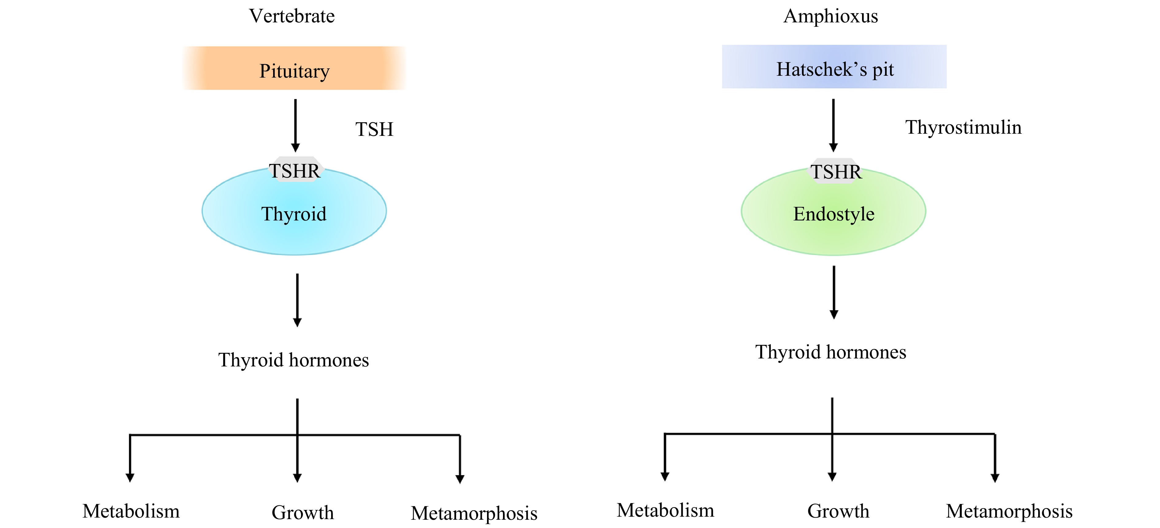
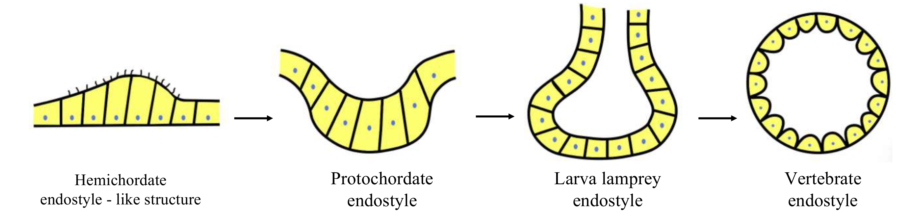
All vertebrates have a definitive thyroid gland, or thyroid for short. As a critical organ for growth, development and metabolism, its origin and evolution have long received attention. On the basis of anatomical position, endodermal origination and histological features, the endostyle of amphioxus has been proposed as a homologue to the thyroid of vertebrates. This homology is further supported by the findings that the amphioxus endostyle abounds in thyroid hormones, possesses several thyroid-specific proteins such as thyroperoxidase, NADPH oxidase and thyroglobulin, and expresses the thyroid-related transcription factors involved in the regulation of development of the vertebrate thyroid, including Nkx2.1, FoxE4 and Pax2/5/8. Importantly, our study on functionality, together with others, indicates significant similarities between the amphioxus endostyle and the vertebrate thyroid gland. Moreover, we show that the production of thyroid hormones by the amphioxus endostyle is mediated in a fashion similar to that of the vertebrate thyroid. These provide solid evidences that the amphioxus endostyle is the homologue of the vertebrate thyroid. From a phylogenetic viewpoint, we propose that the hypobranchial ridge, or endostyle-like structure, of hemichordates is the most primitive forerunner of the thyroid, from which the vertebrate thyroid is formed through the transformation of non-follicular endostyle of amphioxus to follicular endocrine organ of vertebrates. We also raise a couple of questions that demand further study.
All vertebrates have a definitive thyroid gland, or thyroid for short. As a critical organ for growth, development and metabolism, its origin and evolution have long received attention. On the basis of anatomical position, endodermal origination and histological features, the endostyle of amphioxus has been proposed as a homologue to the thyroid of vertebrates. This homology is further supported by the findings that the amphioxus endostyle abounds in thyroid hormones, possesses several thyroid-specific proteins such as thyroperoxidase, NADPH oxidase and thyroglobulin, and expresses the thyroid-related transcription factors involved in the regulation of development of the vertebrate thyroid, including Nkx2.1, FoxE4 and Pax2/5/8. Importantly, our study on functionality, together with others, indicates significant similarities between the amphioxus endostyle and the vertebrate thyroid gland. Moreover, we show that the production of thyroid hormones by the amphioxus endostyle is mediated in a fashion similar to that of the vertebrate thyroid. These provide solid evidences that the amphioxus endostyle is the homologue of the vertebrate thyroid. From a phylogenetic viewpoint, we propose that the hypobranchial ridge, or endostyle-like structure, of hemichordates is the most primitive forerunner of the thyroid, from which the vertebrate thyroid is formed through the transformation of non-follicular endostyle of amphioxus to follicular endocrine organ of vertebrates. We also raise a couple of questions that demand further study.

, Available online ,
doi: 10.1007/s13131-024-2394-8
Abstract:
Spartina alterniflora Loisel is now listed among the world’s 100 most dangerous invasive species, severely affecting the ecological balance of coastal wetlands. Remote sensing technologies based on deep learning enable large-scale monitoring of Spartina alterniflora, but they require large datasets and have poor interpretability. A new method is proposed to detect Spartina alterniflora Loisel from Sentinel-2 imagery. Firstly, to get the high canopy cover and dense community characteristics of Spartina alterniflora Loisel, multi-dimensional shallow features are extracted from the imagery. Secondly, to detect different objects from satellite imagery, index features are extracted, and the statistical features of the gray-level co-occurrence matrix (GLCM) are derived using Principal Component Analysis - Gray-Level Co-Occurrence Matrix (PCA-GLCM). Then, ensemble learning methods, including Random Forest (RF), eXtreme Gradient Boosting (XGBoost), and Light Gradient Boosting Machine (LightGBM) models, are employed for image classification. Meanwhile, Recursive Feature Elimination with Cross-Validation (RFECV) is used to select the best feature subset. Finally, to enhance the interpretability of the models, the best features are utilized to classify multi-temporal images and SHapley Additive exPlanations (SHAP) is combined with these classifications to explain the model prediction process. The method is validated by using Sentinel-2 imageries and previous observations of Spartina alterniflora Loisel in Chongming Island, it is found that the model combining image texture features such as GLCM covariance can significantly improve the detection accuracy of Spartina alterniflora by about 8% compared with the model without image texture features. Through multiple model comparisons and feature selection via RFECV, the selected model and eight features demonstrated good classification accuracy when applied to data from different time periods, proving that feature reduction can effectively enhance model generalization. Additionally, visualizing model decisions using SHAP revealed that the image texture feature component_1_GLCMVariance is particularly important for identifying each land cover type.
Spartina alterniflora Loisel is now listed among the world’s 100 most dangerous invasive species, severely affecting the ecological balance of coastal wetlands. Remote sensing technologies based on deep learning enable large-scale monitoring of Spartina alterniflora, but they require large datasets and have poor interpretability. A new method is proposed to detect Spartina alterniflora Loisel from Sentinel-2 imagery. Firstly, to get the high canopy cover and dense community characteristics of Spartina alterniflora Loisel, multi-dimensional shallow features are extracted from the imagery. Secondly, to detect different objects from satellite imagery, index features are extracted, and the statistical features of the gray-level co-occurrence matrix (GLCM) are derived using Principal Component Analysis - Gray-Level Co-Occurrence Matrix (PCA-GLCM). Then, ensemble learning methods, including Random Forest (RF), eXtreme Gradient Boosting (XGBoost), and Light Gradient Boosting Machine (LightGBM) models, are employed for image classification. Meanwhile, Recursive Feature Elimination with Cross-Validation (RFECV) is used to select the best feature subset. Finally, to enhance the interpretability of the models, the best features are utilized to classify multi-temporal images and SHapley Additive exPlanations (SHAP) is combined with these classifications to explain the model prediction process. The method is validated by using Sentinel-2 imageries and previous observations of Spartina alterniflora Loisel in Chongming Island, it is found that the model combining image texture features such as GLCM covariance can significantly improve the detection accuracy of Spartina alterniflora by about 8% compared with the model without image texture features. Through multiple model comparisons and feature selection via RFECV, the selected model and eight features demonstrated good classification accuracy when applied to data from different time periods, proving that feature reduction can effectively enhance model generalization. Additionally, visualizing model decisions using SHAP revealed that the image texture feature component_1_GLCMVariance is particularly important for identifying each land cover type.


, Available online ,
doi: 10.1007/s13131-024-2389-5
Abstract:
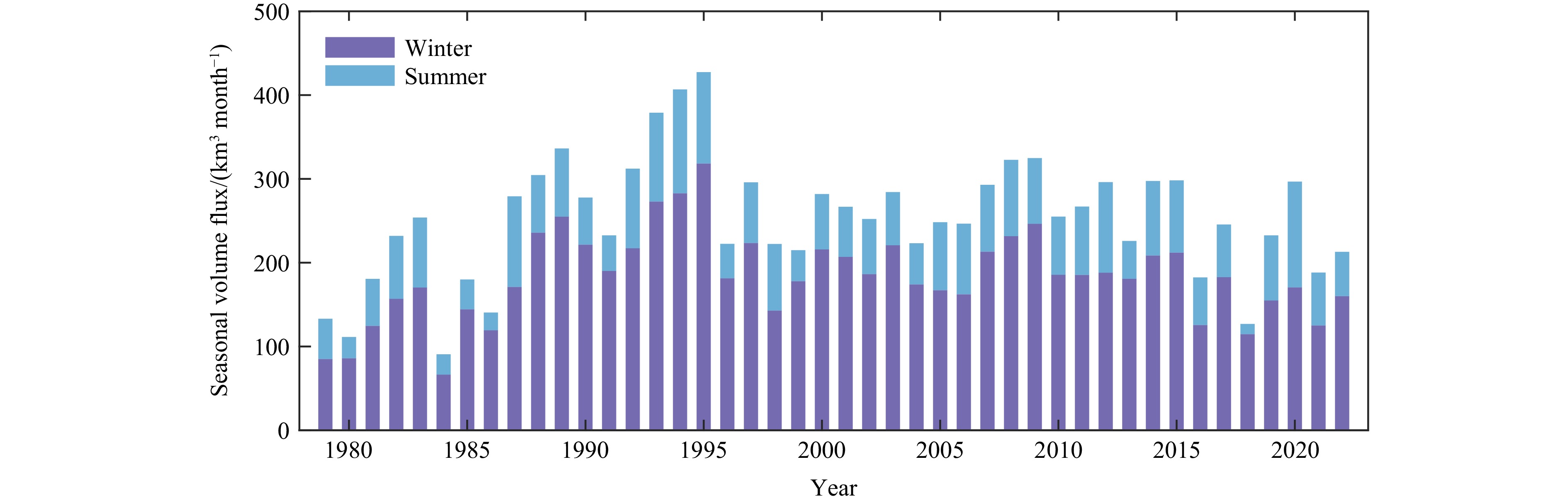
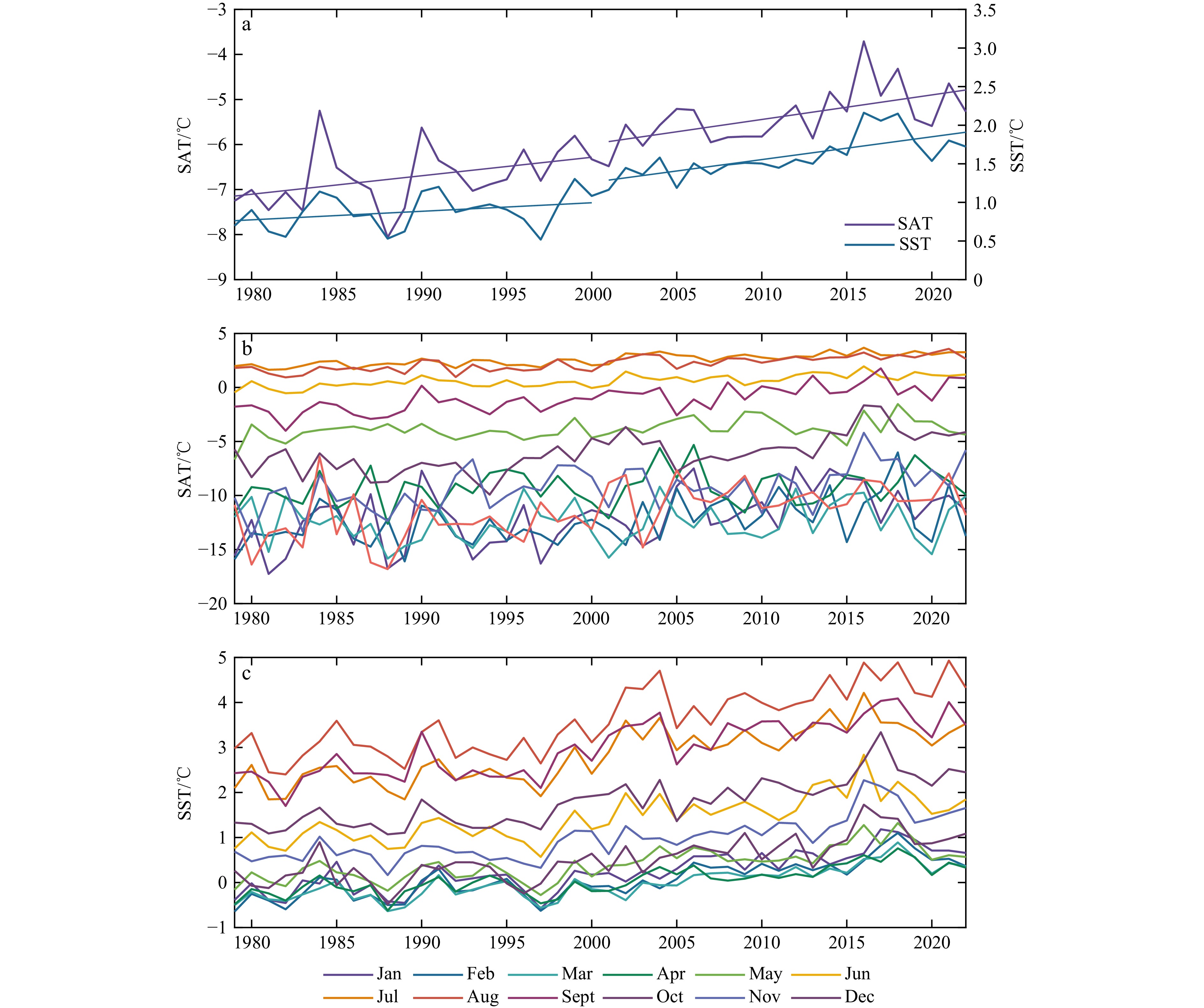
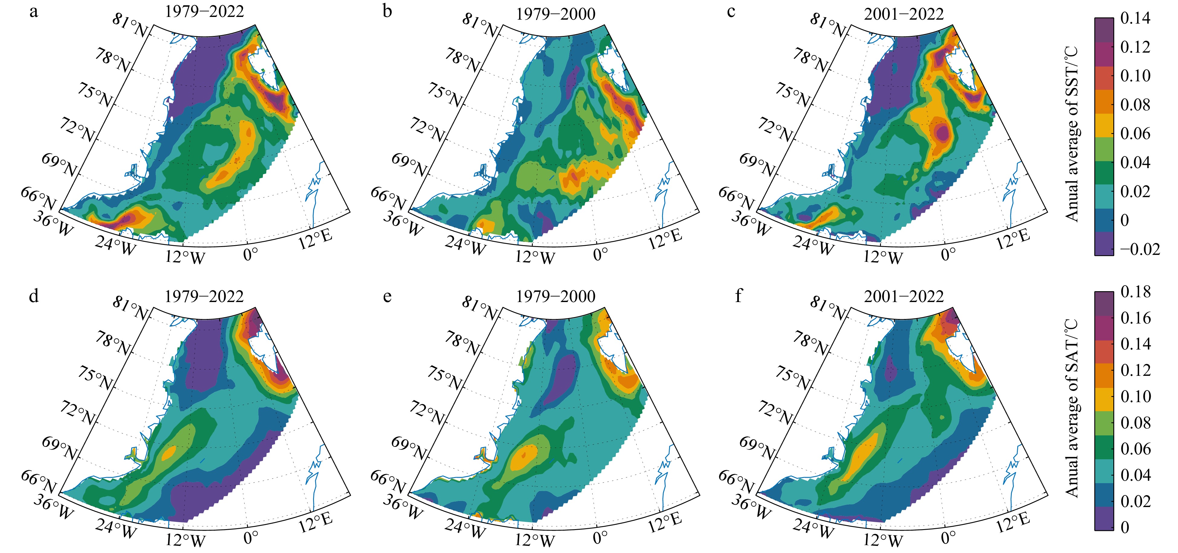
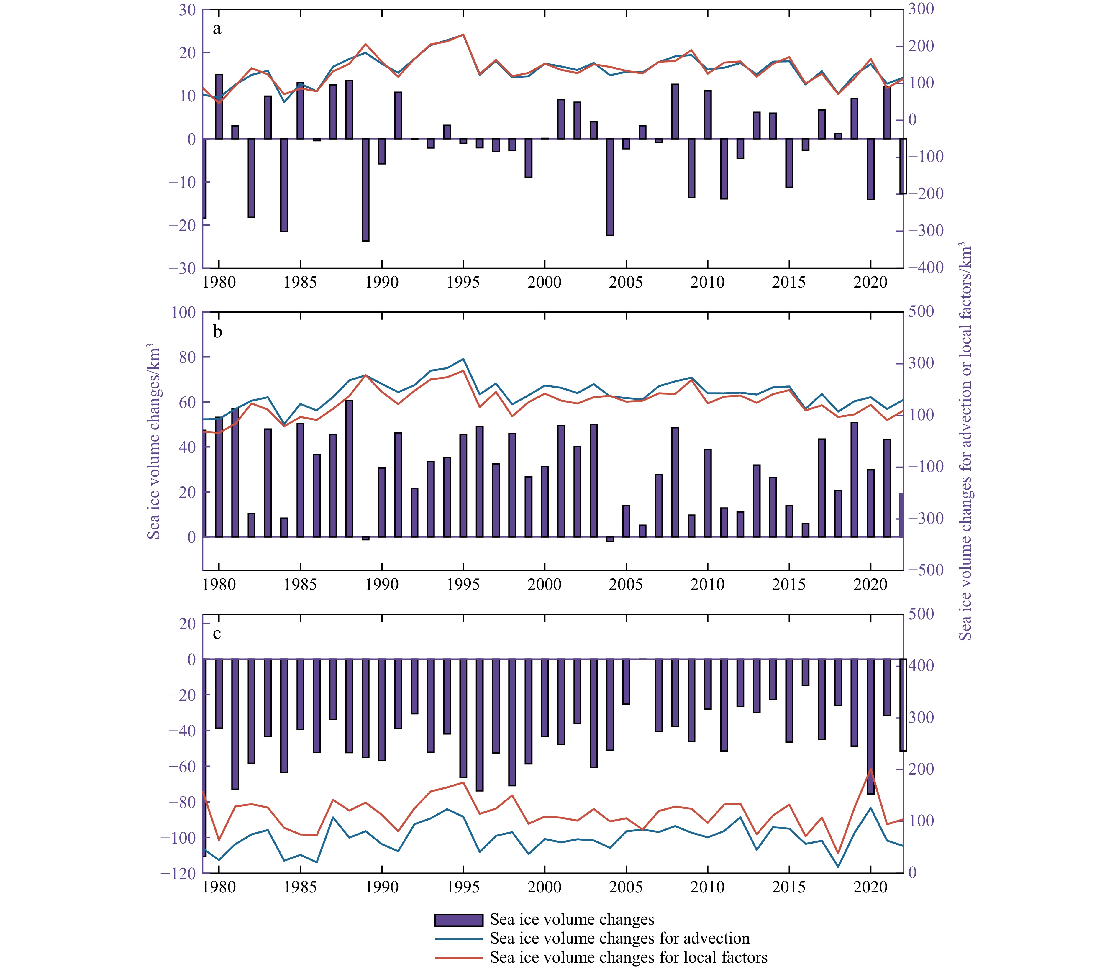
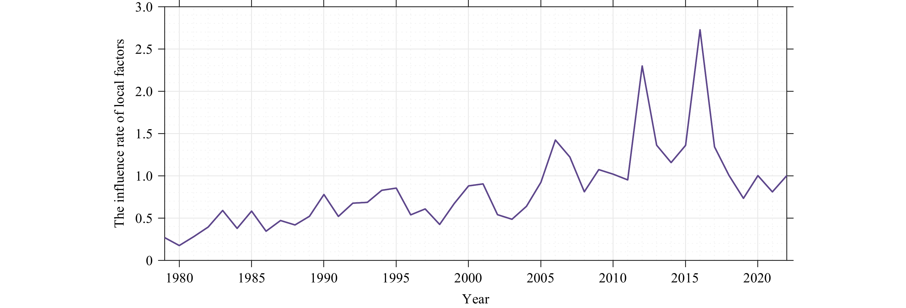
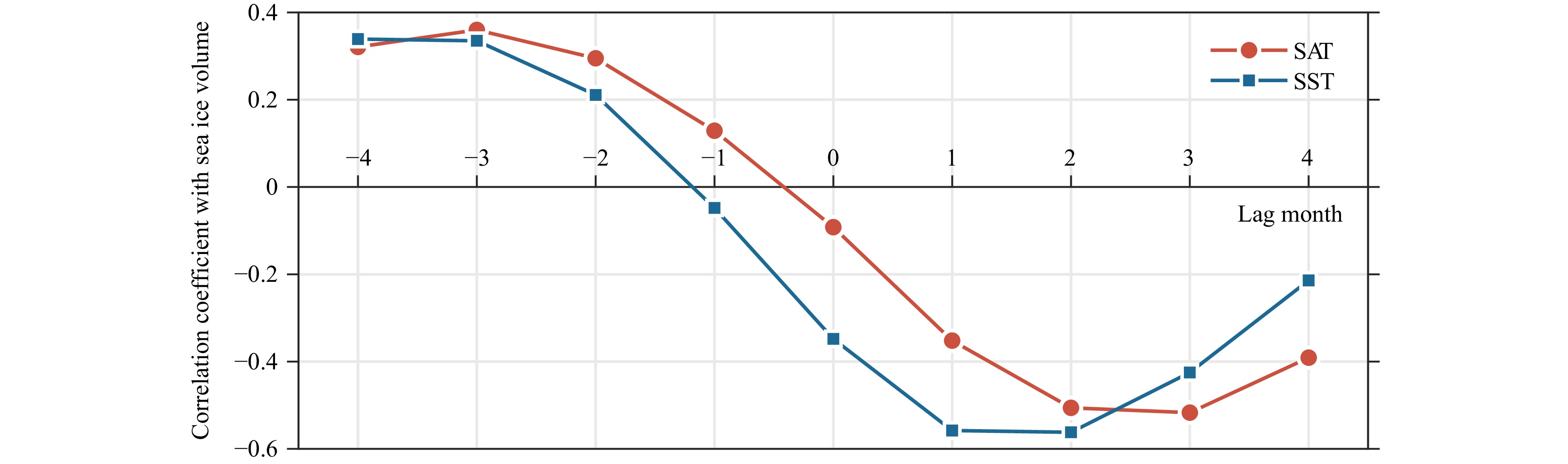
Arctic sea ice is an essential component of the climate system and plays an important role in global climate change. This study calculates the volume flux through Fram Strait (FS) and the sea ice volume in the Greenland Sea (GS) from 1979 to 2022, and analyzes trends before and after 2000. In addition, the contributions of advection and local processes to sea ice volume variations in the GS during different seasons are compared. The influence of the surface air temperature (SAT) and the sea surface temperature (SST) on sea ice volume variations is discussed, as well as the impact of atmospheric circulation on sea ice. Results indicate no significant trend in the sea ice volume flux through FS from 1979 to 2022. However, the sea ice volume in the GS exhibited a notable decreasing trend. Compared with the period of 1979–2000, the sea ice volume decreasing trend accelerated significantly during the period of 2001–2022. During winter, ice advection from the central Arctic Ocean exert a strong influence on the sea ice volume variations in the GS, whereas during summer, local processes, including the interactions with the atmosphere and ocean, as well as the dynamic process of sea ice itself, exert a considerable impact. The sea ice volume in the GS declined rapidly after 2000. Furthermore, the effects of local processes on sea ice have intensified, with the SST exerting a stronger influence on the sea ice volume variations in the GS than the SAT. The positive Arctic oscillation and dipole anomaly are important drivers for the transport of Arctic sea ice to the GS. The Winter North Atlantic oscillation intensifies ocean heat content, affecting sea ice in the GS.
Arctic sea ice is an essential component of the climate system and plays an important role in global climate change. This study calculates the volume flux through Fram Strait (FS) and the sea ice volume in the Greenland Sea (GS) from 1979 to 2022, and analyzes trends before and after 2000. In addition, the contributions of advection and local processes to sea ice volume variations in the GS during different seasons are compared. The influence of the surface air temperature (SAT) and the sea surface temperature (SST) on sea ice volume variations is discussed, as well as the impact of atmospheric circulation on sea ice. Results indicate no significant trend in the sea ice volume flux through FS from 1979 to 2022. However, the sea ice volume in the GS exhibited a notable decreasing trend. Compared with the period of 1979–2000, the sea ice volume decreasing trend accelerated significantly during the period of 2001–2022. During winter, ice advection from the central Arctic Ocean exert a strong influence on the sea ice volume variations in the GS, whereas during summer, local processes, including the interactions with the atmosphere and ocean, as well as the dynamic process of sea ice itself, exert a considerable impact. The sea ice volume in the GS declined rapidly after 2000. Furthermore, the effects of local processes on sea ice have intensified, with the SST exerting a stronger influence on the sea ice volume variations in the GS than the SAT. The positive Arctic oscillation and dipole anomaly are important drivers for the transport of Arctic sea ice to the GS. The Winter North Atlantic oscillation intensifies ocean heat content, affecting sea ice in the GS.


, Available online ,
doi: 10.1007/s13131-024-2396-6
Abstract:
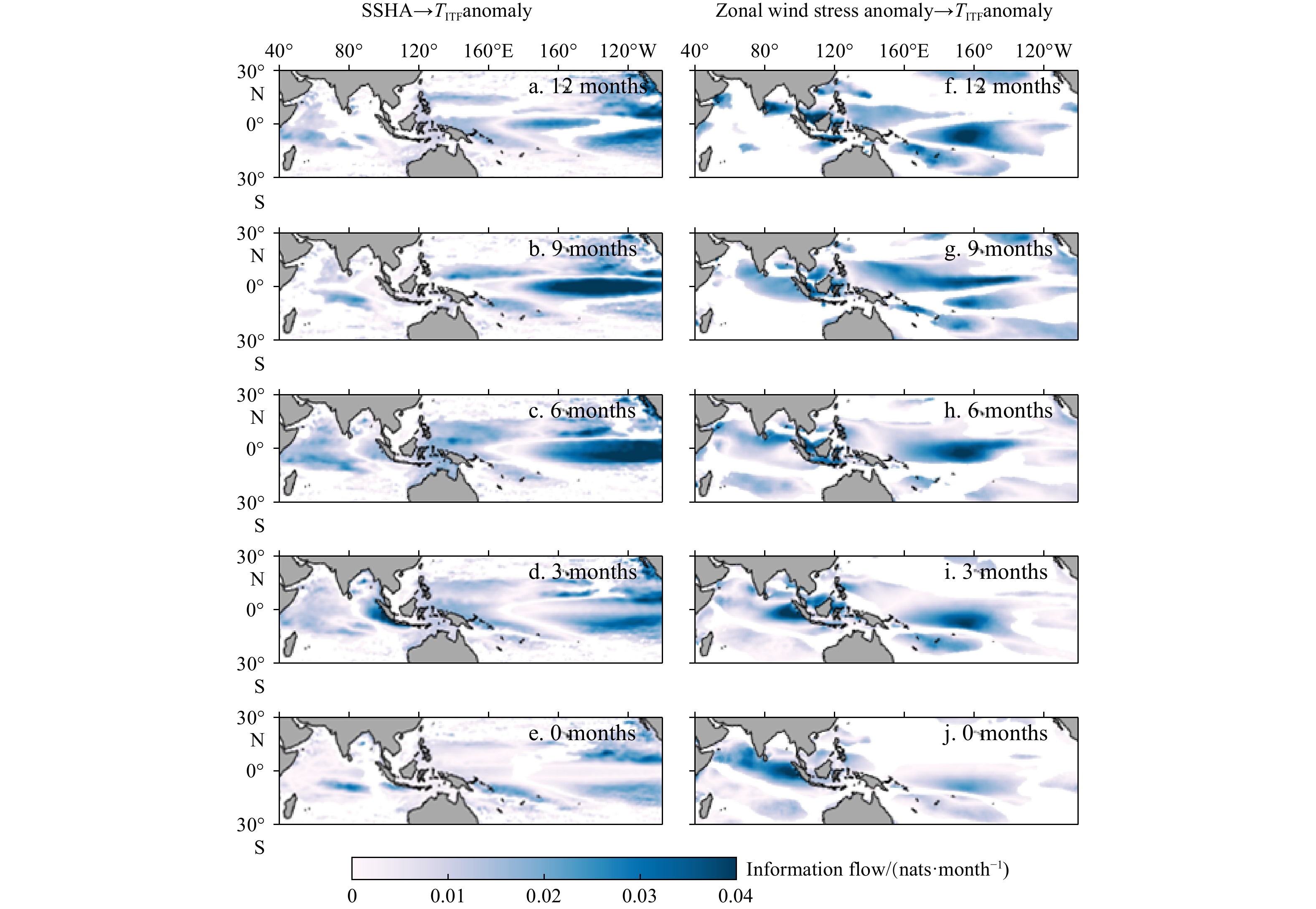
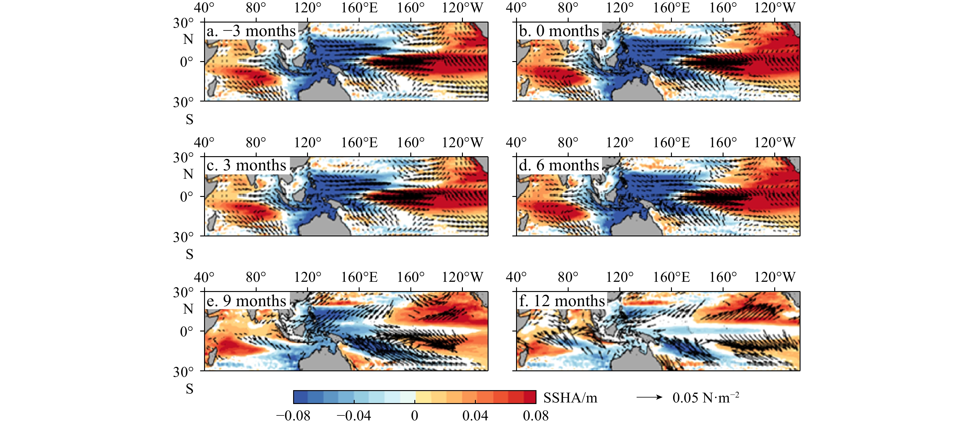
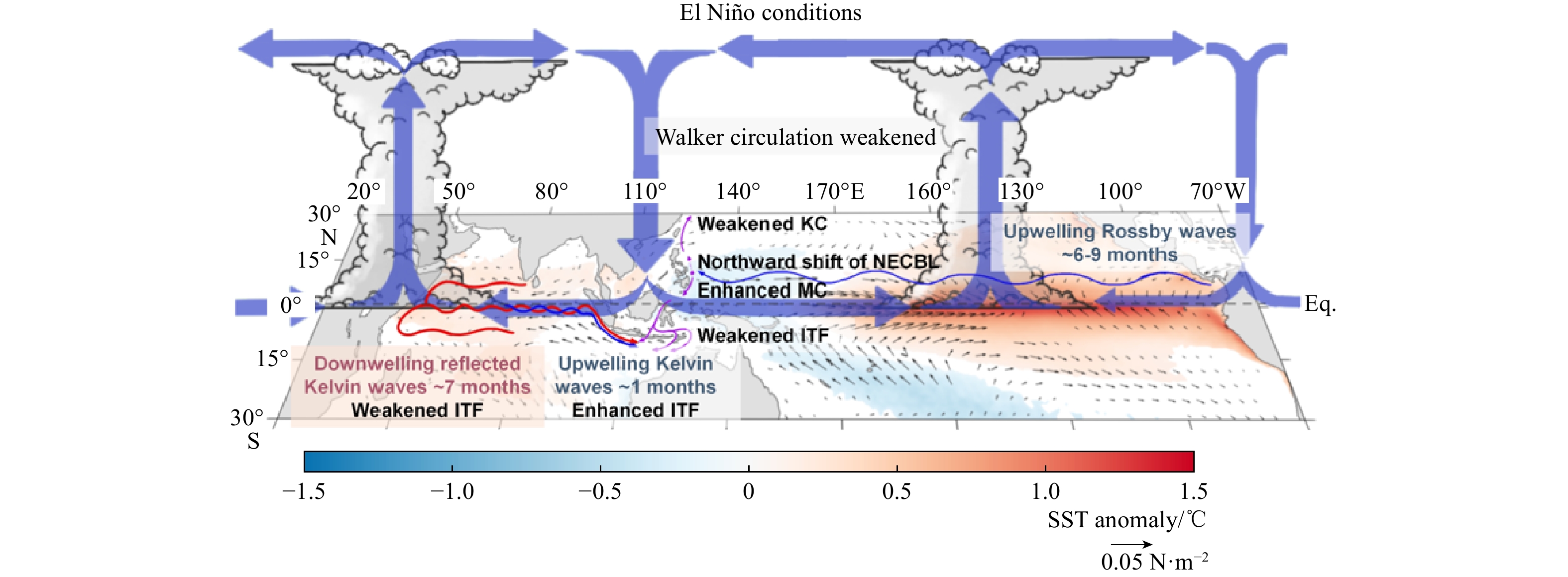
The Indonesian Throughflow (ITF) plays important roles in global ocean circulation and climate systems. Previous studies suggested the ITF interannual variability is driven by both the El Niño-Southern Oscillation (ENSO) and the Indian Ocean Dipole (IOD) events. The detailed processes of ENSO and/or IOD induced anomalies impacting on the ITF, however, are still not clear. In this study, this issue is investigated through causal relation, statistical and dynamical analyses based on satellite observation. The results show that the driven mechanisms of ENSO on the ITF include two aspects. Firstly, the ENSO related wind field anomalies driven anomalous cyclonic ocean circulation in the western Pacific, and off equatorial upwelling Rossby waves propagating westward to arrive at the western boundary of the Pacific, both tend to induce negative sea surface height anomalies (SSHA) in the western Pacific, favoring ITF reduction since the develop of the El Niño through the following year. Secondly, the ENSO events modulate equatorial Indian Ocean zonal winds through Walker Circulation, which in turn trigger eastward propagating upwelling Kelvin waves and westward propagating downwelling Rossby waves. The Rossby waves are reflected into downwelling Kelvin waves, which then propagate eastward along the equator and the Sumatra-Java coast in the Indian Ocean. As a result, the wave dynamics tend to generate negative (positive) SSHA in the eastern Indian Ocean, and thus enhance (reduce) the ITF transport with time lag of 0–6 (9–12) month, respectively. Under the IOD condition, the wave dynamics also tend to enhance the ITF in the positive IOD year, and reduce the ITF in the following year.
The Indonesian Throughflow (ITF) plays important roles in global ocean circulation and climate systems. Previous studies suggested the ITF interannual variability is driven by both the El Niño-Southern Oscillation (ENSO) and the Indian Ocean Dipole (IOD) events. The detailed processes of ENSO and/or IOD induced anomalies impacting on the ITF, however, are still not clear. In this study, this issue is investigated through causal relation, statistical and dynamical analyses based on satellite observation. The results show that the driven mechanisms of ENSO on the ITF include two aspects. Firstly, the ENSO related wind field anomalies driven anomalous cyclonic ocean circulation in the western Pacific, and off equatorial upwelling Rossby waves propagating westward to arrive at the western boundary of the Pacific, both tend to induce negative sea surface height anomalies (SSHA) in the western Pacific, favoring ITF reduction since the develop of the El Niño through the following year. Secondly, the ENSO events modulate equatorial Indian Ocean zonal winds through Walker Circulation, which in turn trigger eastward propagating upwelling Kelvin waves and westward propagating downwelling Rossby waves. The Rossby waves are reflected into downwelling Kelvin waves, which then propagate eastward along the equator and the Sumatra-Java coast in the Indian Ocean. As a result, the wave dynamics tend to generate negative (positive) SSHA in the eastern Indian Ocean, and thus enhance (reduce) the ITF transport with time lag of 0–6 (9–12) month, respectively. Under the IOD condition, the wave dynamics also tend to enhance the ITF in the positive IOD year, and reduce the ITF in the following year.


, Available online ,
doi: 10.1007/s13131-024-2392-x
Abstract:
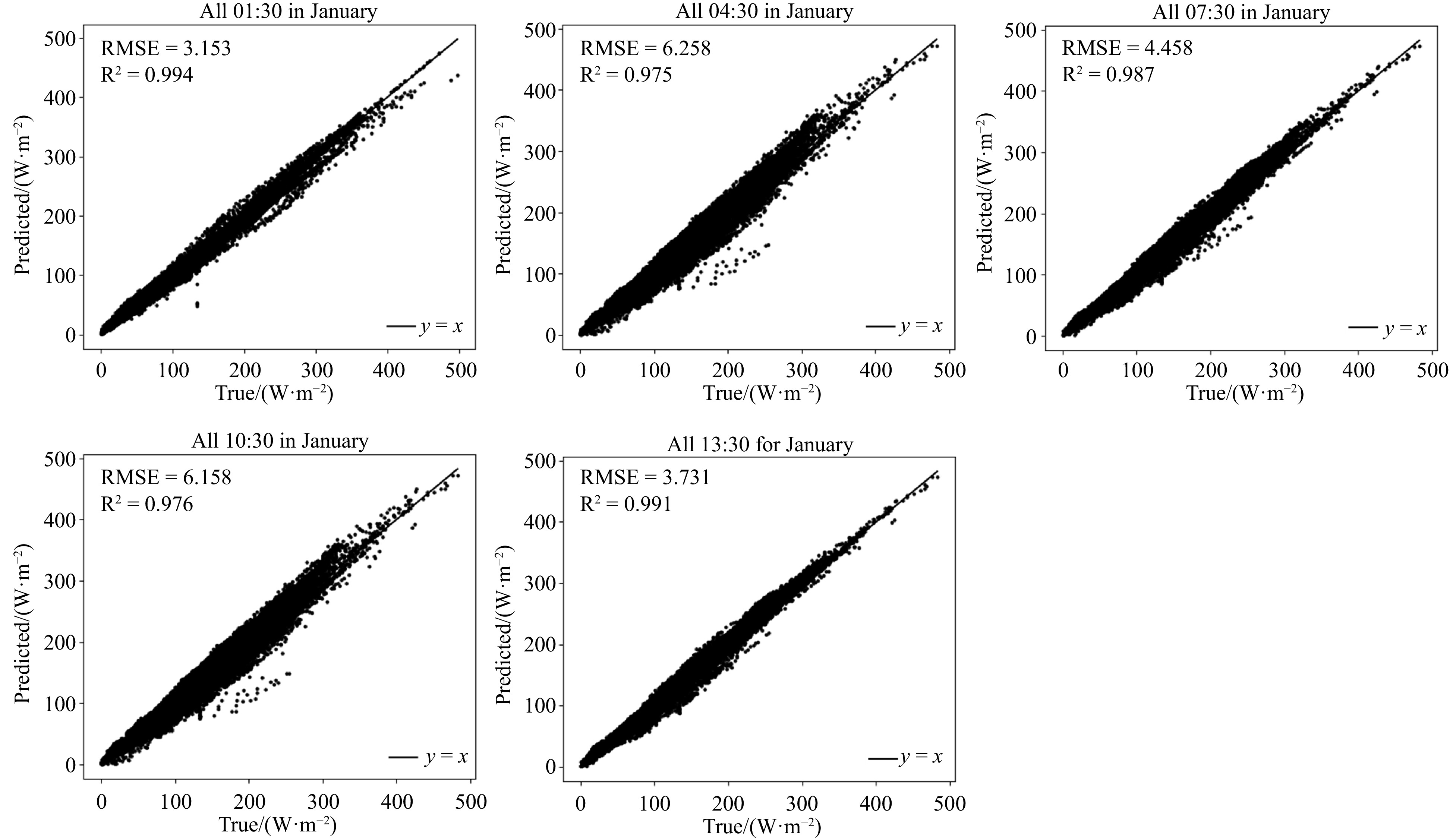
Efficient and accurate prediction of ocean surface latent heat fluxes is essential for understanding and modeling climate dynamics. Conventional estimation methods have low resolution and lack accuracy. The Transformer model, with its self-attention mechanism, effectively captures long-range dependencies, leading to a degradation of accuracy over time. Due to the non-linearity and uncertainty of physical processes, the Transformer model encounters the problem of error accumulation, leading to a degradation of accuracy over time. To solve this problem, we combine the data assimilation technique with the Transformer model and continuously modify the model state to make it closer to the actual observations. In this paper, we propose a deep learning model called TransNetDA, which integrates Transformer, Convolutional Neural Network and data assimilation methods. By combining data-driven and data assimilation methods for spatiotemporal prediction, TransNetDA effectively extracts multi-scale spatial features and significantly improves prediction accuracy. The experimental results indicate that the TransNetDA method surpasses traditional techniques in terms of RMSE and R2 metrics, showcasing its superior performance in predicting latent heat fluxes at the ocean surface.
Efficient and accurate prediction of ocean surface latent heat fluxes is essential for understanding and modeling climate dynamics. Conventional estimation methods have low resolution and lack accuracy. The Transformer model, with its self-attention mechanism, effectively captures long-range dependencies, leading to a degradation of accuracy over time. Due to the non-linearity and uncertainty of physical processes, the Transformer model encounters the problem of error accumulation, leading to a degradation of accuracy over time. To solve this problem, we combine the data assimilation technique with the Transformer model and continuously modify the model state to make it closer to the actual observations. In this paper, we propose a deep learning model called TransNetDA, which integrates Transformer, Convolutional Neural Network and data assimilation methods. By combining data-driven and data assimilation methods for spatiotemporal prediction, TransNetDA effectively extracts multi-scale spatial features and significantly improves prediction accuracy. The experimental results indicate that the TransNetDA method surpasses traditional techniques in terms of RMSE and R2 metrics, showcasing its superior performance in predicting latent heat fluxes at the ocean surface.


, Available online
Abstract:
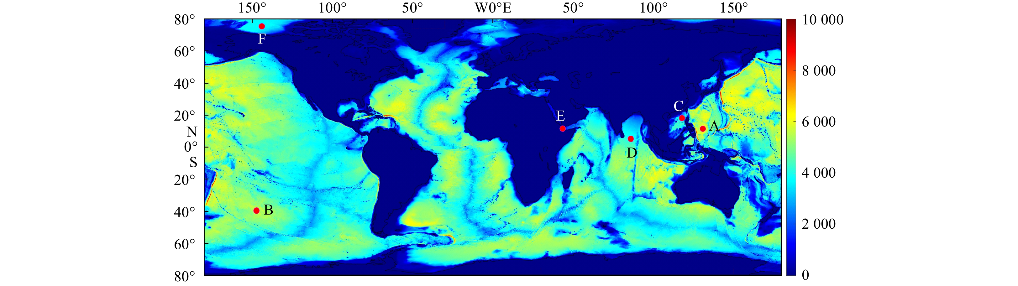
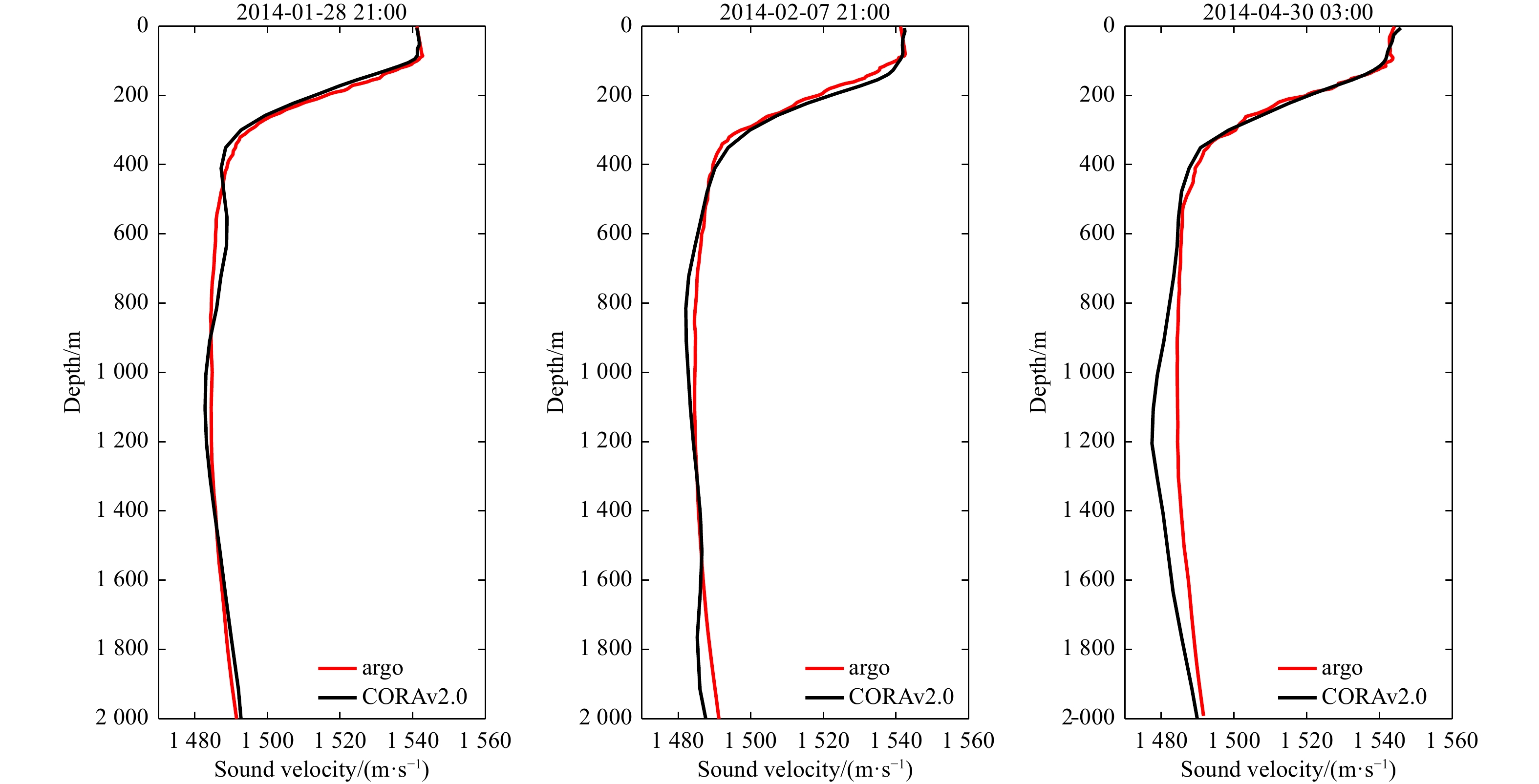
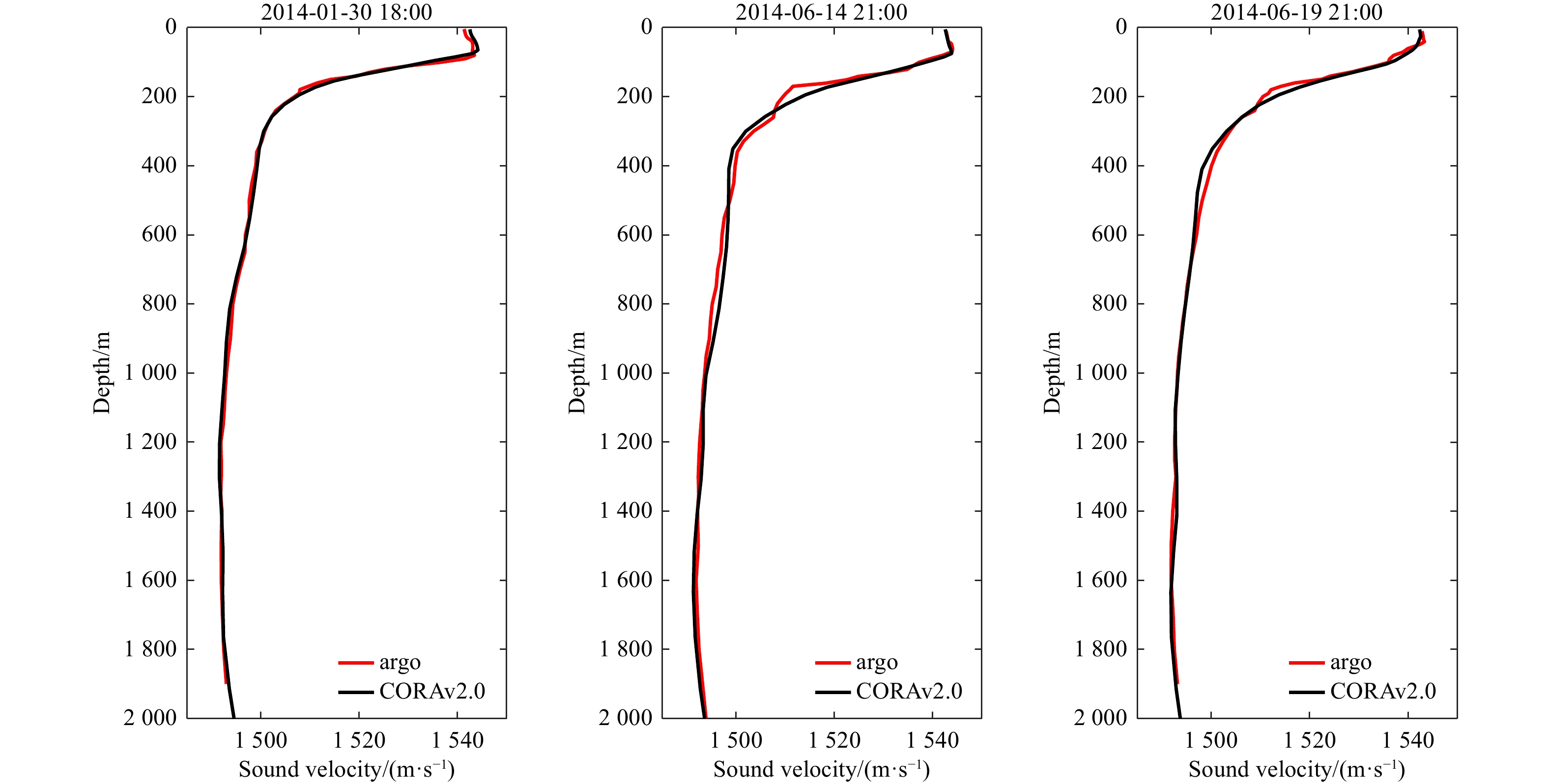
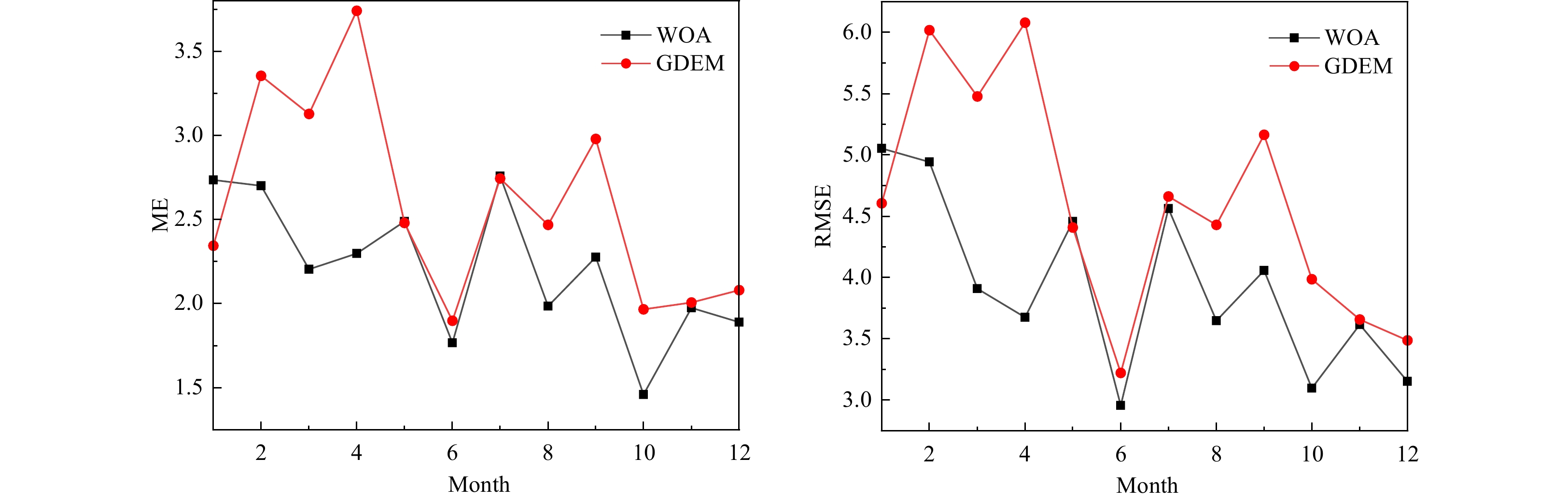
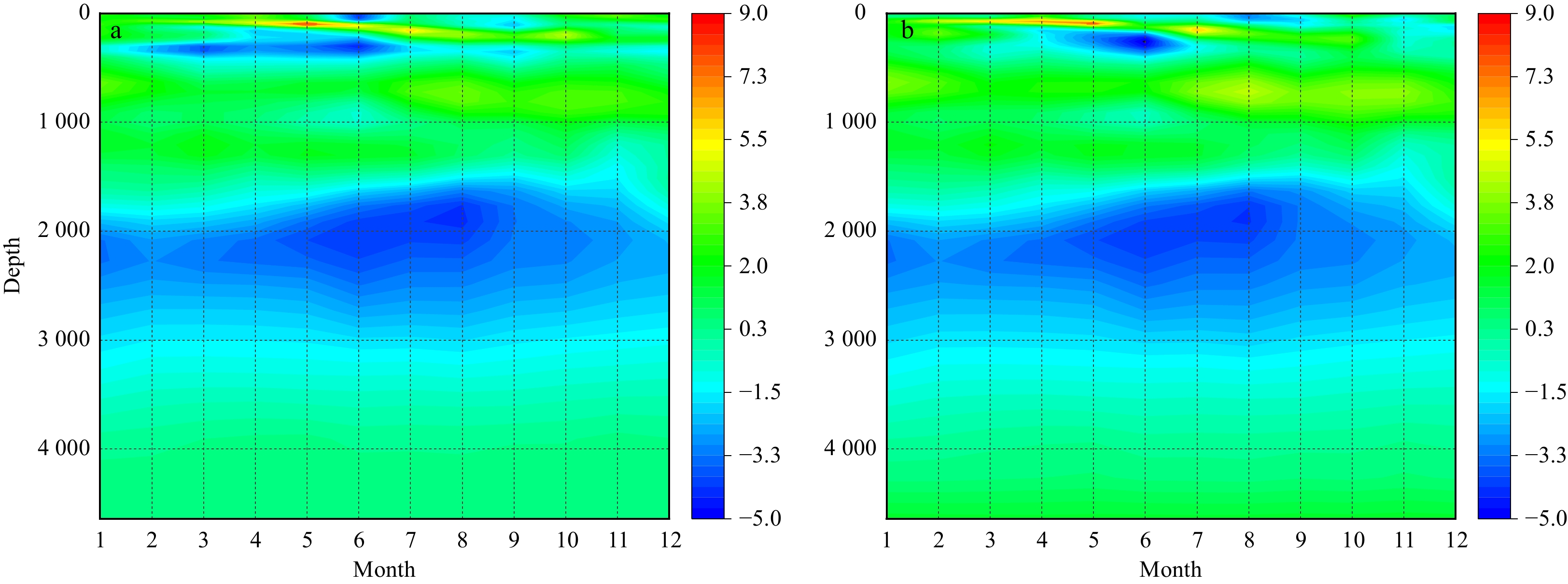
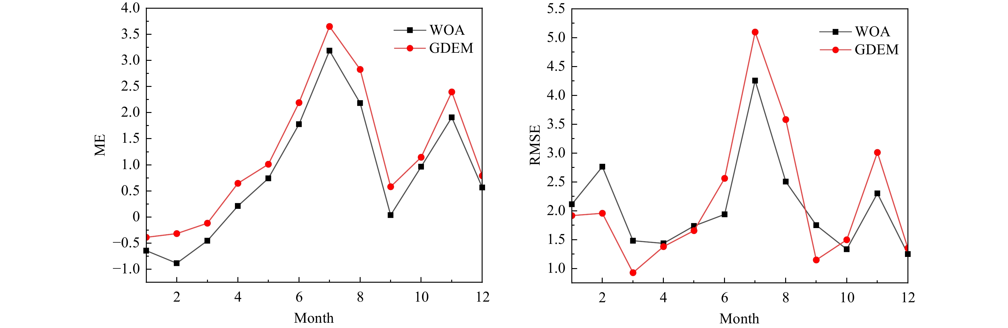
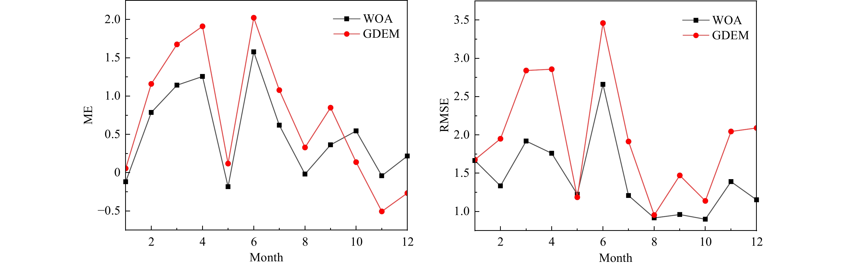
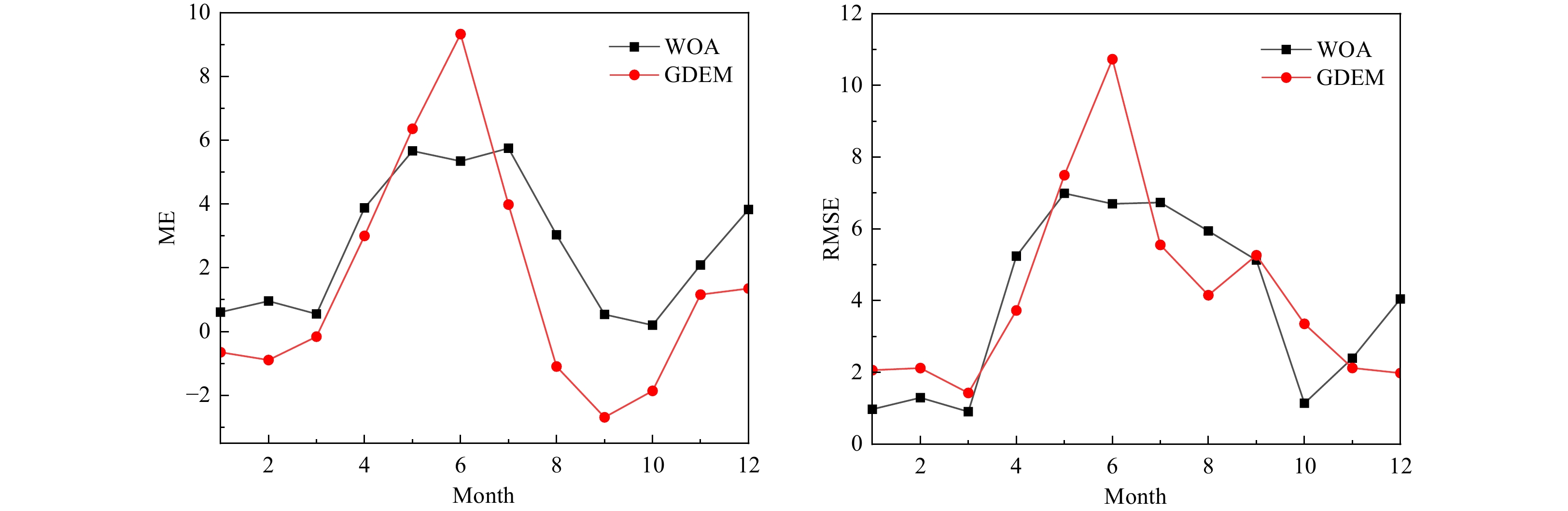
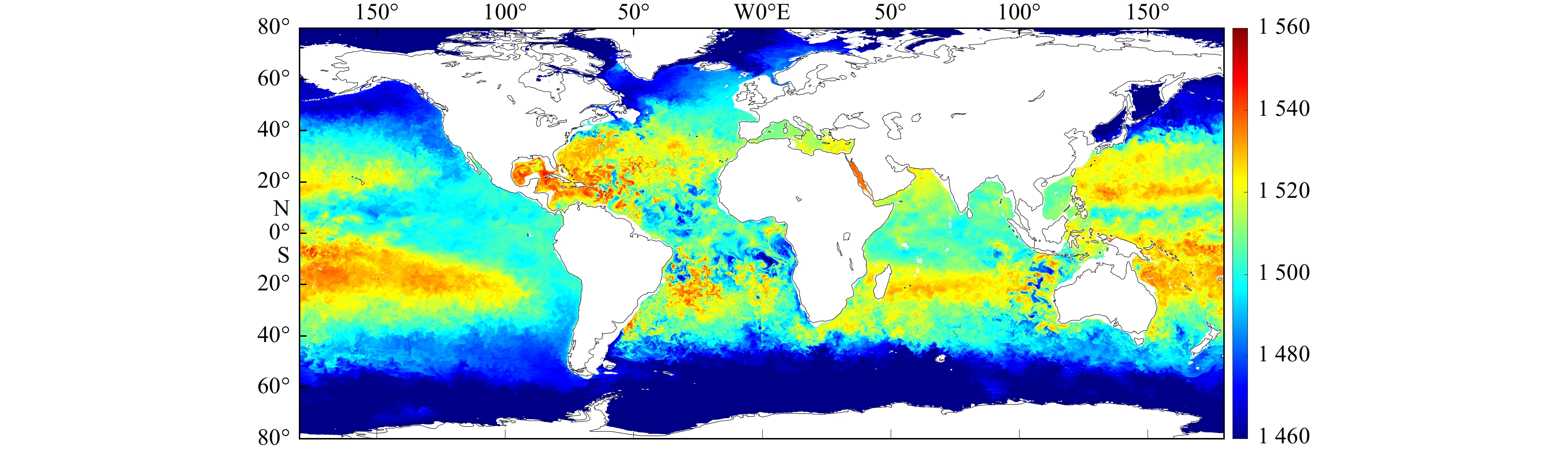
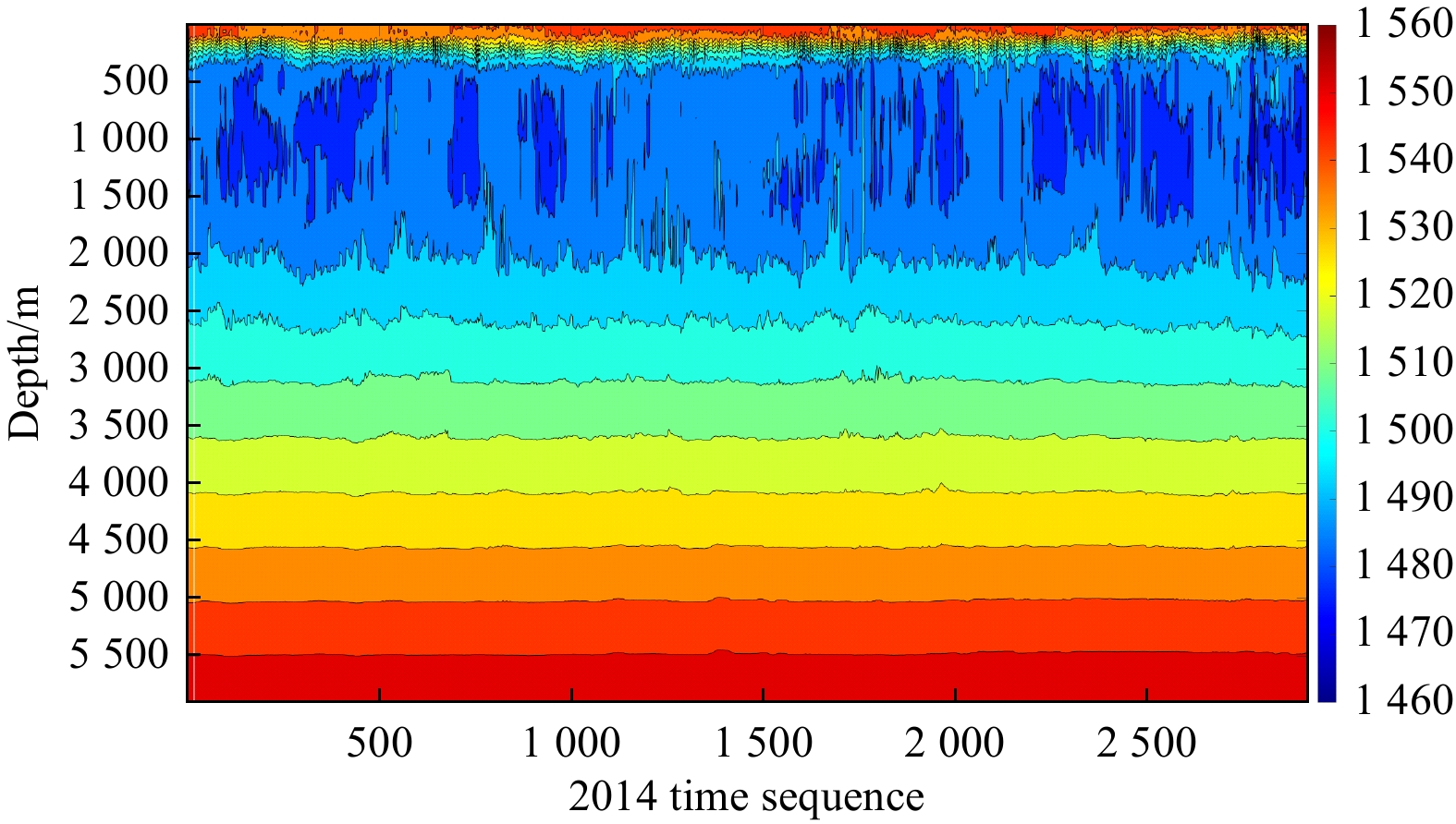
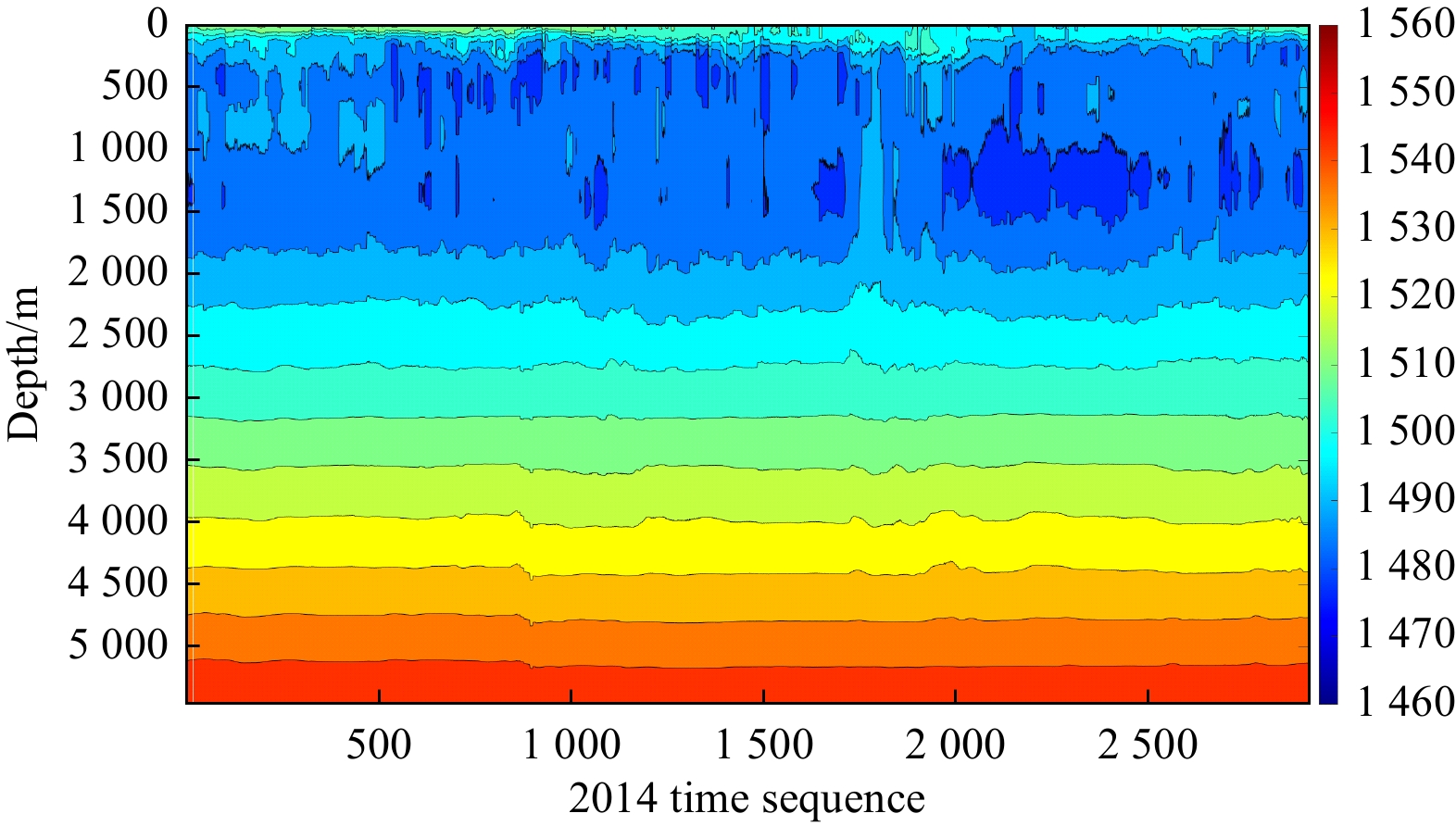
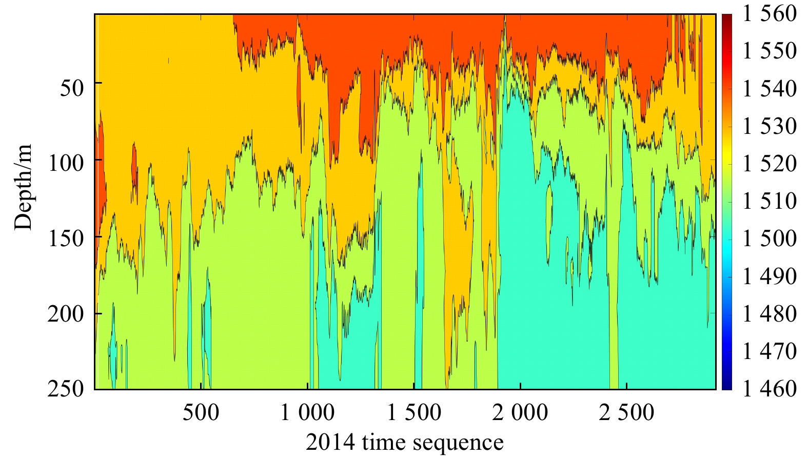
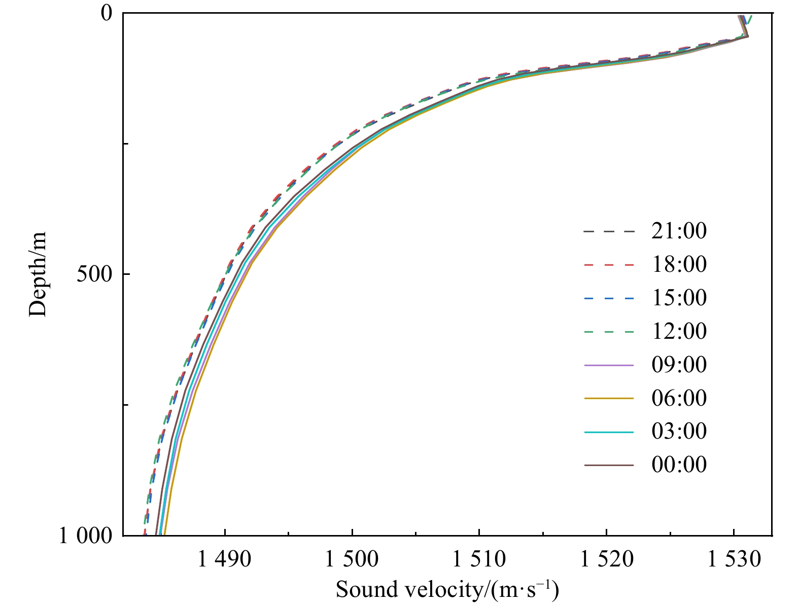
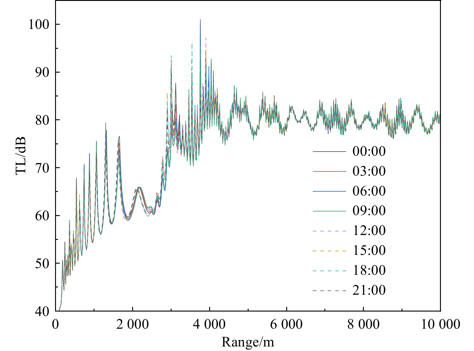
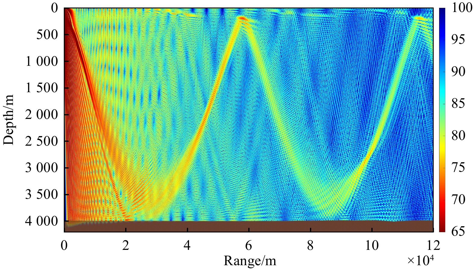
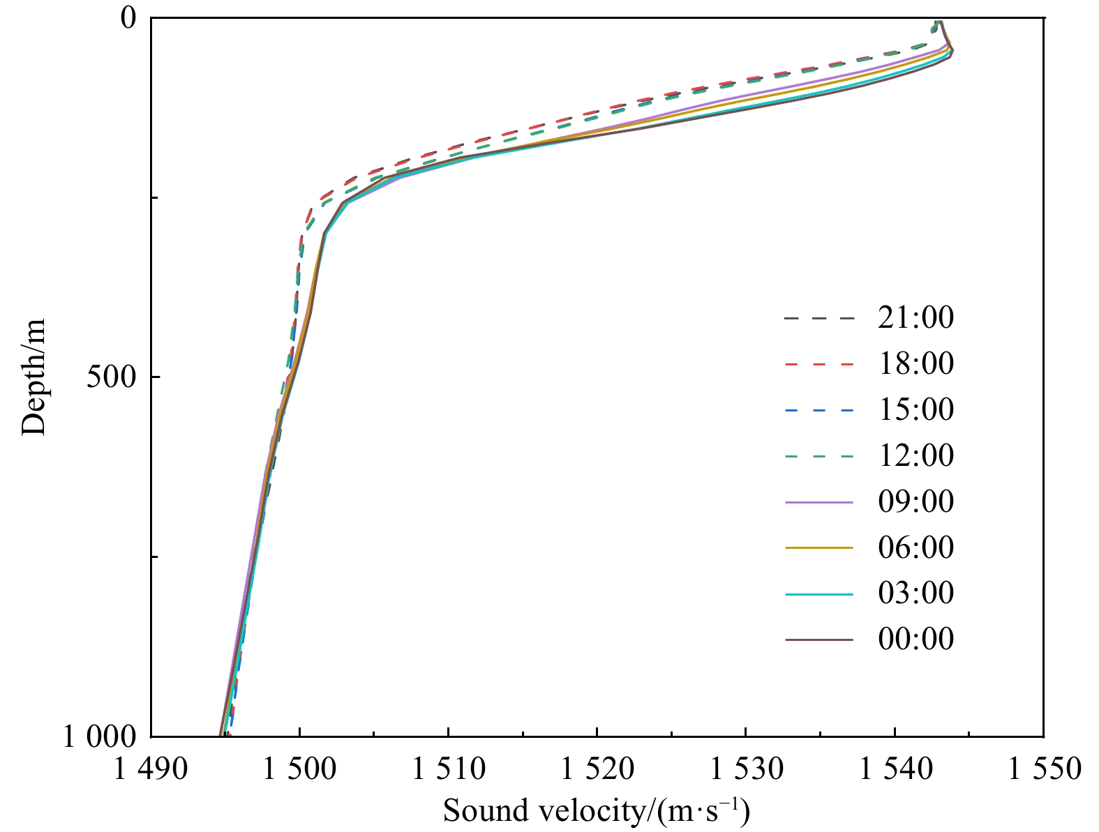
Ocean reanalysis data, compared to traditional observational data, possess stronger continuity and higher data accuracy. The globally high-resolution ice–ocean coupled reanalysis product CORA v2.0 (China Ocean ReAnalysis, Version 2.0), independently developed by the National Marine Information Center, has attracted considerable attention since its release in 2020. This paper selected six representative points of sound velocity profiles in different global ocean regions and conducted comparative analysis between the 2014 momentary data from CORA v2.0 and Argo data. Additionally, the monthly average data of CORA v2.0 in 2013 were compared and studied against GDEM (General Digital Environmental Model) and WOA (World Ocean Atlas) data. Metrics such as RMSE and ME were introduced to evaluate the differences between datasets. The study found that, in a comparison of single moment data, the sound velocity profiles of CORA v2.0 data and Argo data exhibit high consistency, with ME generally within 2 m/s. Regarding a comparison of monthly average data, the consistency between CORA v2.0 data and WOA data is higher, while the error relative to GDEM data is relatively larger, but their RMSE and ME exhibit high similarity in temporal trends. Based on the 2014 data of CORA v2.0, the temporal and spatial evolutionary laws of global seawater sound velocity profiles and sound velocity fields were analyzed. On the time scale, the variation of seawater sound velocity is mainly influenced by seasons, with significant differences between winter and summer seasons. On the daily scale, there are certain differences in sound velocity profiles mainly in the early morning and afternoon. On the spatial scale, analysis was conducted from both horizontal and vertical perspectives. The distribution of sound velocity exhibits evident regularity with latitude, with shallow seawater sound velocity being greatly influenced by external factors while deep seawater is relatively stable. Using the RAMgeo model to solve the underwater acoustic field at three specific points, the characteristic changes of sound velocity profiles at different times of the day and their impact on under water sound propagation losses were obtained. This study provides valuable information for the application of CORA v2.0 data products.
Ocean reanalysis data, compared to traditional observational data, possess stronger continuity and higher data accuracy. The globally high-resolution ice–ocean coupled reanalysis product CORA v2.0 (China Ocean ReAnalysis, Version 2.0), independently developed by the National Marine Information Center, has attracted considerable attention since its release in 2020. This paper selected six representative points of sound velocity profiles in different global ocean regions and conducted comparative analysis between the 2014 momentary data from CORA v2.0 and Argo data. Additionally, the monthly average data of CORA v2.0 in 2013 were compared and studied against GDEM (General Digital Environmental Model) and WOA (World Ocean Atlas) data. Metrics such as RMSE and ME were introduced to evaluate the differences between datasets. The study found that, in a comparison of single moment data, the sound velocity profiles of CORA v2.0 data and Argo data exhibit high consistency, with ME generally within 2 m/s. Regarding a comparison of monthly average data, the consistency between CORA v2.0 data and WOA data is higher, while the error relative to GDEM data is relatively larger, but their RMSE and ME exhibit high similarity in temporal trends. Based on the 2014 data of CORA v2.0, the temporal and spatial evolutionary laws of global seawater sound velocity profiles and sound velocity fields were analyzed. On the time scale, the variation of seawater sound velocity is mainly influenced by seasons, with significant differences between winter and summer seasons. On the daily scale, there are certain differences in sound velocity profiles mainly in the early morning and afternoon. On the spatial scale, analysis was conducted from both horizontal and vertical perspectives. The distribution of sound velocity exhibits evident regularity with latitude, with shallow seawater sound velocity being greatly influenced by external factors while deep seawater is relatively stable. Using the RAMgeo model to solve the underwater acoustic field at three specific points, the characteristic changes of sound velocity profiles at different times of the day and their impact on under water sound propagation losses were obtained. This study provides valuable information for the application of CORA v2.0 data products.


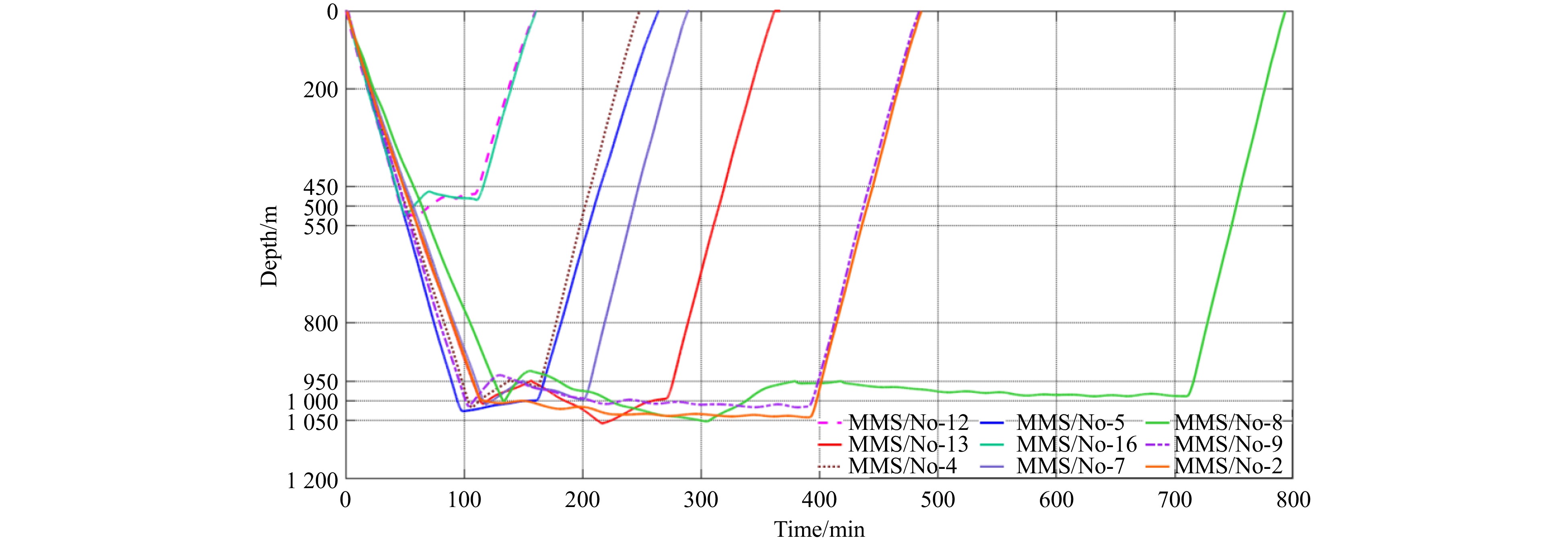
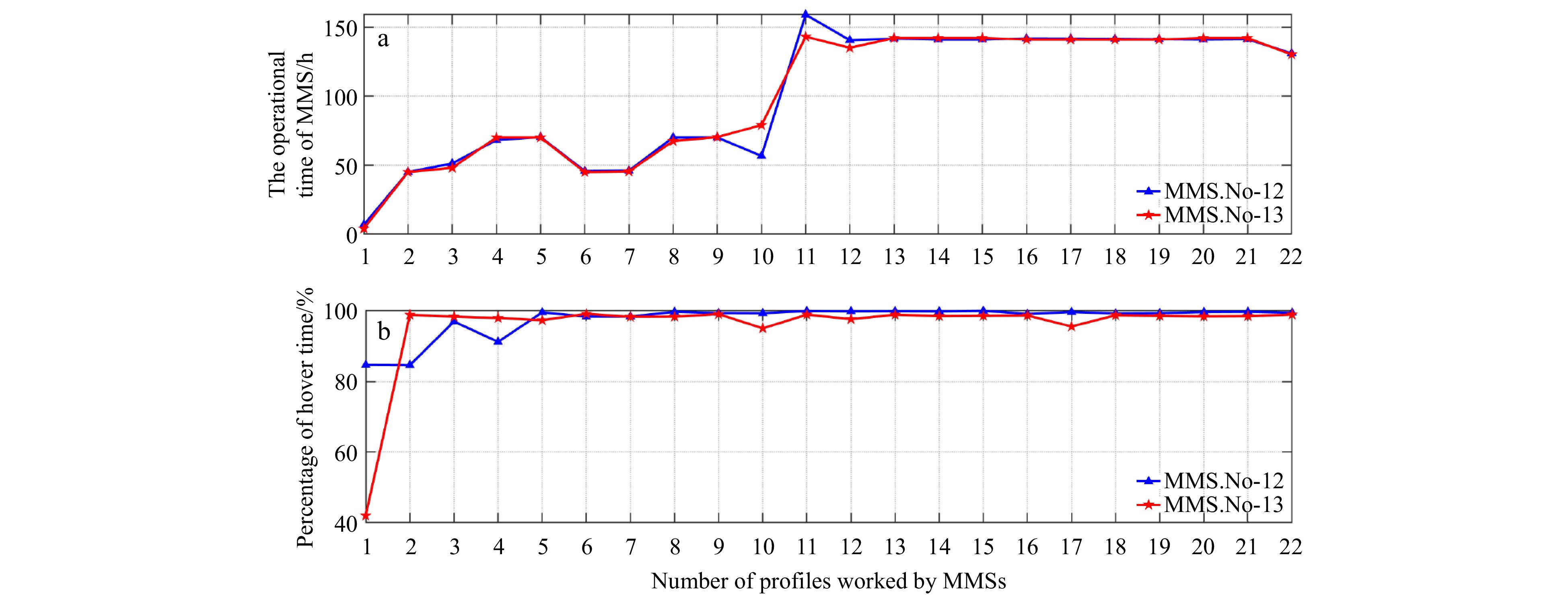
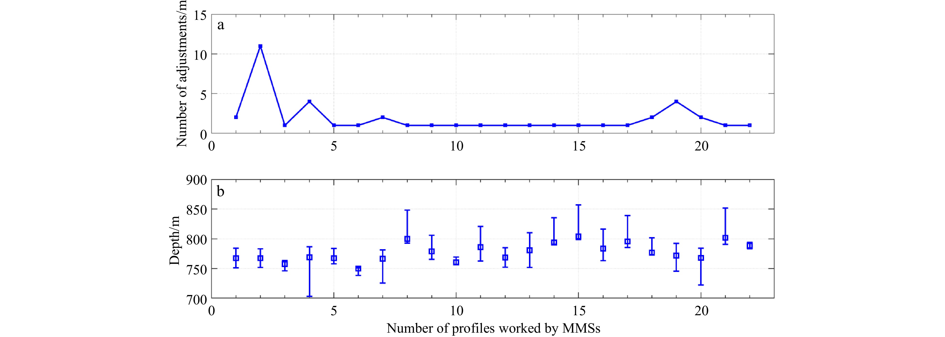
A new fixed-depth suspension control algorithm for mobile marine seismometer and its testing results
, Available online
Abstract:
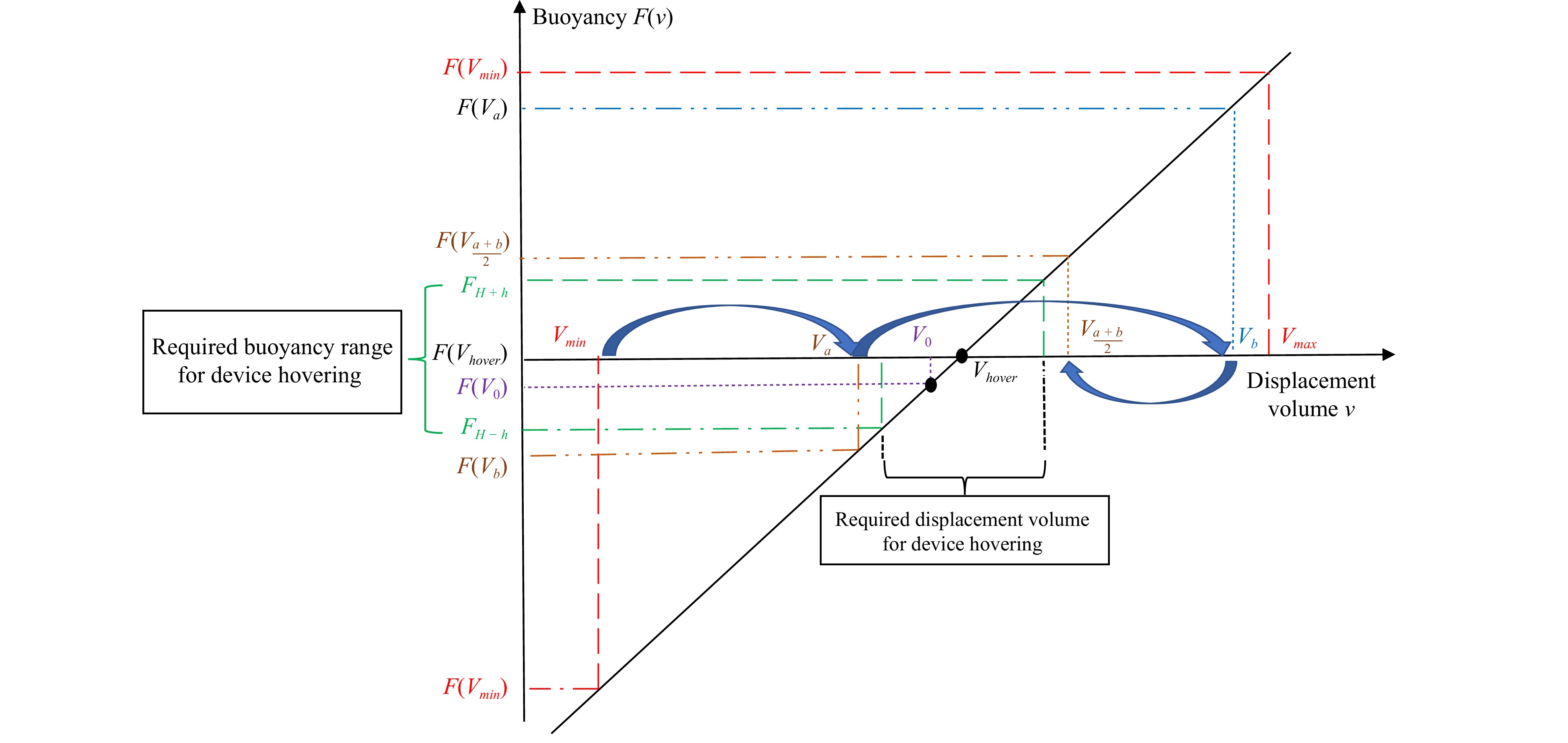
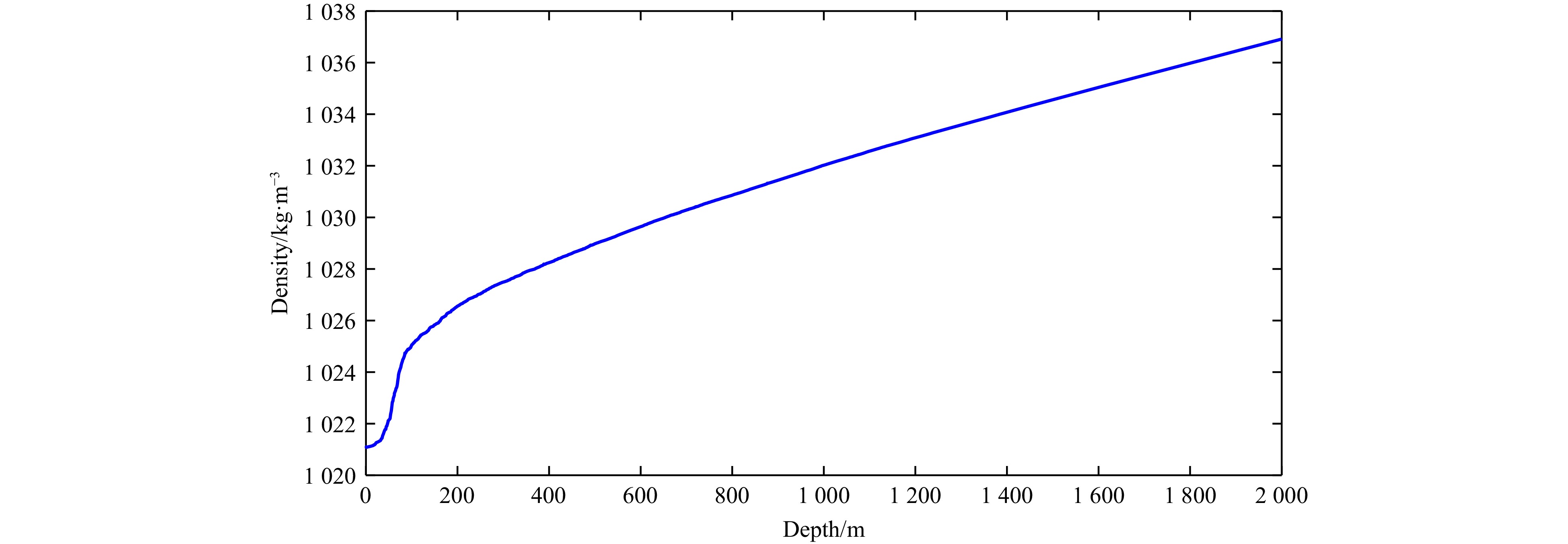
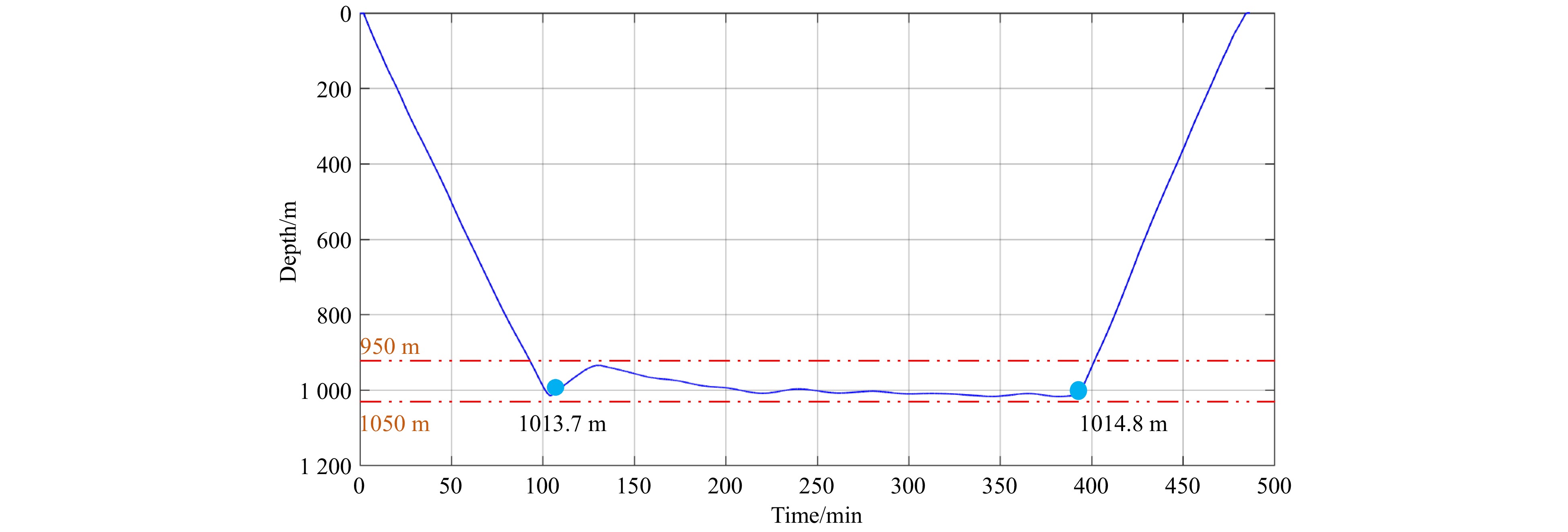
A mobile marine seismometer (MMS) is a vertical underwater vehicle that detects ocean seismic waves. One of the critical operational requirements for an MMS is that it remains suspended at a desired depth. This article aimed to propose a fixed-depth suspension control for the MMS with a limited onboard energy supply. The research team established a kinematic model to analyze fluctuations in the vertical motion of the MMS and the delayed response of the system. We ascertained a direct one-to-one correlation between the displacement volume of the mobile ocean seismic instrument and the depth at which it reaches a state of neutral buoyancy (commonly referred to as the hover depth). A fixed-depth control algorithm was introduced, allowing a gradual approach to the necessary displacement volume to reach the desired suspension depth. The study optimized the boundary conditions to reduce unnecessary adjustments and mitigate the time delay caused by the instrument’s inertia, thereby significantly minimizing energy consumption. This method does not require calculating the hydrodynamic parameters or transfer functions of the MMS, thereby considerably reducing the implementation complexity. In the three-month sea trial in the South China Sea, the seismic instrument was set to hover at 800 meters, with a permissible fluctuation of ±100 meters, operating on a seven-day cycle. The experimental results show that the seismic instrument has an average hover error of 34.6 meters, with a vertical drift depth of 29.6 meters per cycle, and the buoyancy adjustment system made six adjustments, indicating that our proposed control method performs satisfactorily. In addition, this method provides new insights for the fixed-depth control of other ocean observation devices that rely on buoyancy adjustment.
A mobile marine seismometer (MMS) is a vertical underwater vehicle that detects ocean seismic waves. One of the critical operational requirements for an MMS is that it remains suspended at a desired depth. This article aimed to propose a fixed-depth suspension control for the MMS with a limited onboard energy supply. The research team established a kinematic model to analyze fluctuations in the vertical motion of the MMS and the delayed response of the system. We ascertained a direct one-to-one correlation between the displacement volume of the mobile ocean seismic instrument and the depth at which it reaches a state of neutral buoyancy (commonly referred to as the hover depth). A fixed-depth control algorithm was introduced, allowing a gradual approach to the necessary displacement volume to reach the desired suspension depth. The study optimized the boundary conditions to reduce unnecessary adjustments and mitigate the time delay caused by the instrument’s inertia, thereby significantly minimizing energy consumption. This method does not require calculating the hydrodynamic parameters or transfer functions of the MMS, thereby considerably reducing the implementation complexity. In the three-month sea trial in the South China Sea, the seismic instrument was set to hover at 800 meters, with a permissible fluctuation of ±100 meters, operating on a seven-day cycle. The experimental results show that the seismic instrument has an average hover error of 34.6 meters, with a vertical drift depth of 29.6 meters per cycle, and the buoyancy adjustment system made six adjustments, indicating that our proposed control method performs satisfactorily. In addition, this method provides new insights for the fixed-depth control of other ocean observation devices that rely on buoyancy adjustment.


, Available online ,
doi: 10.1007/s13131-020-0000-1
Abstract:
The year, 2024, marks the 40th anniversary of Chinese research expeditions in the polar regions and the 25th anniversary of its Arctic research expeditions. China has conducted 14 national Arctic research expeditions. With the increase of understandings on the global impacts of the changes of Arctic climate system, especially on China’s weather and climate, and demands for commercial utilization of the Arctic sea routes, Chinese scientists have made great progresses on on-site and remote sensing observation technologies for Arctic Ocean, interaction mechanisms between atmosphere, sea ice, and ocean, the connection mechanism between the Arctic Ocean and other regions, and have achieved a series of research results. This study summarizes the research achievements by Chinese scientists in the above-mentioned aspects or beyond, identifies knowledge gaps, and based on this, discusses prospects and provides suggestions. From a perspective of observation, improving the observation capabilities of the Arctic Ocean in winter and the ocean under the ice, as well as floe-scale processes of sea ice and mesoscale and submesoscale processes of the ocean, is an urgent task to be addressed. Strengthening international cooperation is necessary for building a monitoring network for the Arctic marine environment. From a perspective of numerical simulation, the descriptive ability and parameterization scheme of sub-grid processes based on observational evidence need to be developed. From a perspective of cross-sphere interactions, in addition to the multi-media coupling within the Arctic Ocean that this review focuses on, the interaction between the Arctic Ocean and land or ice sheet (Greenland), especially the water cycle process, is also a scientific domain that needs to be considered, in the context of Arctic warming and humidification. From a perspective of climate effects, the physical mechanisms that affect the robustness of teleconnection need to be clarified.
The year, 2024, marks the 40th anniversary of Chinese research expeditions in the polar regions and the 25th anniversary of its Arctic research expeditions. China has conducted 14 national Arctic research expeditions. With the increase of understandings on the global impacts of the changes of Arctic climate system, especially on China’s weather and climate, and demands for commercial utilization of the Arctic sea routes, Chinese scientists have made great progresses on on-site and remote sensing observation technologies for Arctic Ocean, interaction mechanisms between atmosphere, sea ice, and ocean, the connection mechanism between the Arctic Ocean and other regions, and have achieved a series of research results. This study summarizes the research achievements by Chinese scientists in the above-mentioned aspects or beyond, identifies knowledge gaps, and based on this, discusses prospects and provides suggestions. From a perspective of observation, improving the observation capabilities of the Arctic Ocean in winter and the ocean under the ice, as well as floe-scale processes of sea ice and mesoscale and submesoscale processes of the ocean, is an urgent task to be addressed. Strengthening international cooperation is necessary for building a monitoring network for the Arctic marine environment. From a perspective of numerical simulation, the descriptive ability and parameterization scheme of sub-grid processes based on observational evidence need to be developed. From a perspective of cross-sphere interactions, in addition to the multi-media coupling within the Arctic Ocean that this review focuses on, the interaction between the Arctic Ocean and land or ice sheet (Greenland), especially the water cycle process, is also a scientific domain that needs to be considered, in the context of Arctic warming and humidification. From a perspective of climate effects, the physical mechanisms that affect the robustness of teleconnection need to be clarified.


, Available online
Abstract:
Sea ice and snow are the most sensitive and important crucial components of the global climate system, affecting the global climate by modulating the energy exchange between the ocean and the atmosphere. The sea near Zhongshan Station in Antarctica is covered by landfast sea ice, with snow depth influenced by both thermal factors and wind. This region frequently experiences katabatic winds and cyclones from the westerlies, leading to frequent snow blowing events that redistribute the snow and affects its depth, subsequently impacting the thermodynamic growth of sea ice. This study utilizes the one-dimensional thermodynamic model ICEPACK was to simulate landfast sea ice thickness and snow depth near Zhongshan Station in 2016. Two parameterization schemes for snow blowing, the Bulk scheme and the ITDrdg scheme, were analyzed evaluated for their impact on snow depth. The results showed that simulations using snow blowing schemes more closely align with observed results, with the ITDrdg scheme providing more accurate simulations, evidenced by root mean square errors of less than 10 cm for both snow depth and sea ice thickness. Snow blowing also impacted the thermodynamic growth of sea ice, particularly bottom growth. The sea ice bottom increased by 9.0 cm using the ITDrdg scheme compared to simulations without the snow blowing, accounting for 12.5% of total sea ice bottom growth. Furthermore, snow blowing process also influenced snow ice formation, highlighting its primary role in affecting snow depth. Continued field observations of snow blowing are necessary to evaluate and improve parameterization schemes.
Sea ice and snow are the most sensitive and important crucial components of the global climate system, affecting the global climate by modulating the energy exchange between the ocean and the atmosphere. The sea near Zhongshan Station in Antarctica is covered by landfast sea ice, with snow depth influenced by both thermal factors and wind. This region frequently experiences katabatic winds and cyclones from the westerlies, leading to frequent snow blowing events that redistribute the snow and affects its depth, subsequently impacting the thermodynamic growth of sea ice. This study utilizes the one-dimensional thermodynamic model ICEPACK was to simulate landfast sea ice thickness and snow depth near Zhongshan Station in 2016. Two parameterization schemes for snow blowing, the Bulk scheme and the ITDrdg scheme, were analyzed evaluated for their impact on snow depth. The results showed that simulations using snow blowing schemes more closely align with observed results, with the ITDrdg scheme providing more accurate simulations, evidenced by root mean square errors of less than 10 cm for both snow depth and sea ice thickness. Snow blowing also impacted the thermodynamic growth of sea ice, particularly bottom growth. The sea ice bottom increased by 9.0 cm using the ITDrdg scheme compared to simulations without the snow blowing, accounting for 12.5% of total sea ice bottom growth. Furthermore, snow blowing process also influenced snow ice formation, highlighting its primary role in affecting snow depth. Continued field observations of snow blowing are necessary to evaluate and improve parameterization schemes.


, Available online ,
doi: 10.1007/s13131-024-2301-3
Abstract:
The spatial variability of mesozooplankton (MZ) community characteristics, with an emphasis on the predominant taxa, copepods, were evaluated between two distinct coastal water environments of Mangalore: the Netravati-Gurupura estuarine system (NGES) and the adjacent nearshore waters (<20 m depth) on the southwest coast of India during winter 2018. The nearshore waters were characterised by uniformly distributed hydrographic properties, particularly in terms of water column temperature, salinity and turbidity. This well-mixed water column likely stimulated increased phytoplankton chlorophyll a concentrations (av. 2.9±2.2 mg/m3), which in turn supported higher MZ biomass (av. 0.4±0.15 mL/m3) and abundance (av.6889 ±3387 ind./m3) in the nearshore waters. In contrast, the NGES exhibited highly variable hydrographic conditions, leading to inconsistent chlorophyll a (av. 3.2±3.7 mg/m3), along with significantly lower MZ biomass (av. 0.1±0.2 mL/m3) and abundance (av. 238±339 ind./m3). The MZ community was dominated by herbivorous copepods (HCs), particularly Bestiolina similis, in the entire study region; however, the nearshore waters supported a more diverse taxon. The overall dominance of HCs, e.g., B. similis and Pseudodiaptomous aurivillii, in the nearshore waters, indicates the presence of stable hydrographic conditions, especially consistently higher salinity and chlorophyll a level. In contrast, the unstable hydrographic conditions in the NGES, primarily reflected in the uneven salinity distributions, likely contributed to the reduced MZ biomass and abundance. The relative increase in the abundance of B. similis observed exclusively in the euhaline zones of the estuary highlights the significant influence of neritic waters.
The spatial variability of mesozooplankton (MZ) community characteristics, with an emphasis on the predominant taxa, copepods, were evaluated between two distinct coastal water environments of Mangalore: the Netravati-Gurupura estuarine system (NGES) and the adjacent nearshore waters (<20 m depth) on the southwest coast of India during winter 2018. The nearshore waters were characterised by uniformly distributed hydrographic properties, particularly in terms of water column temperature, salinity and turbidity. This well-mixed water column likely stimulated increased phytoplankton chlorophyll a concentrations (av. 2.9±2.2 mg/m3), which in turn supported higher MZ biomass (av. 0.4±0.15 mL/m3) and abundance (av.


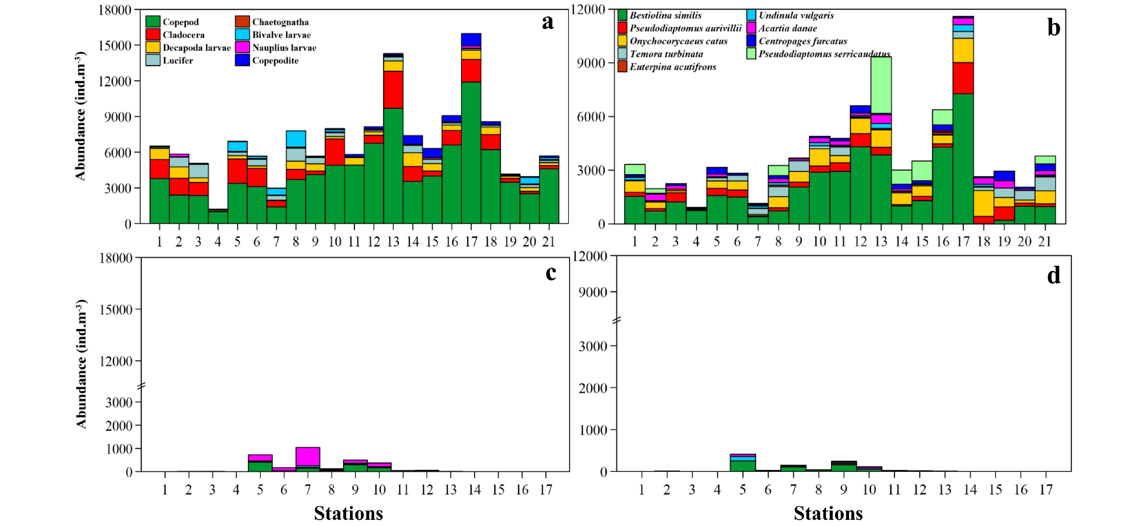
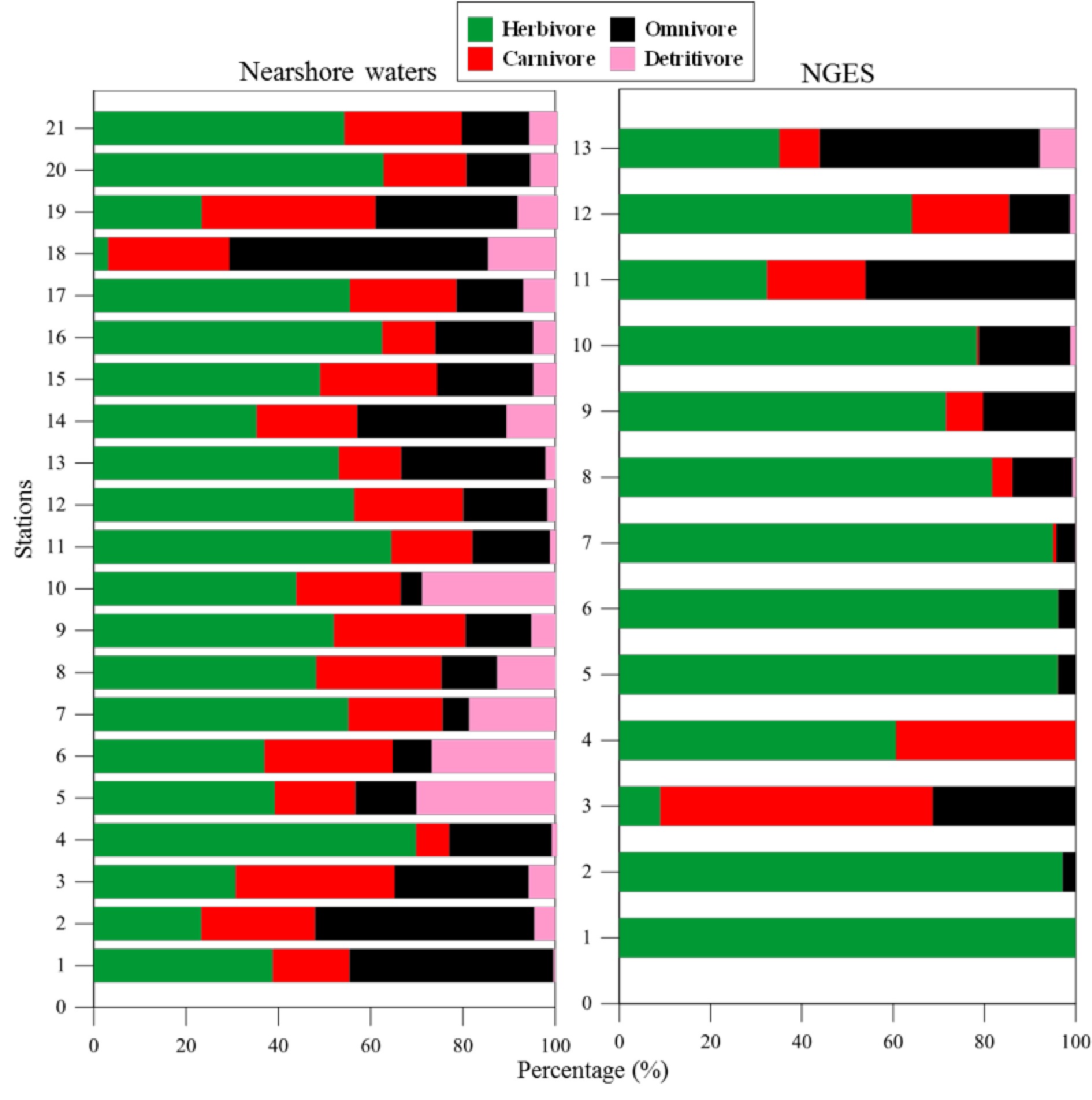
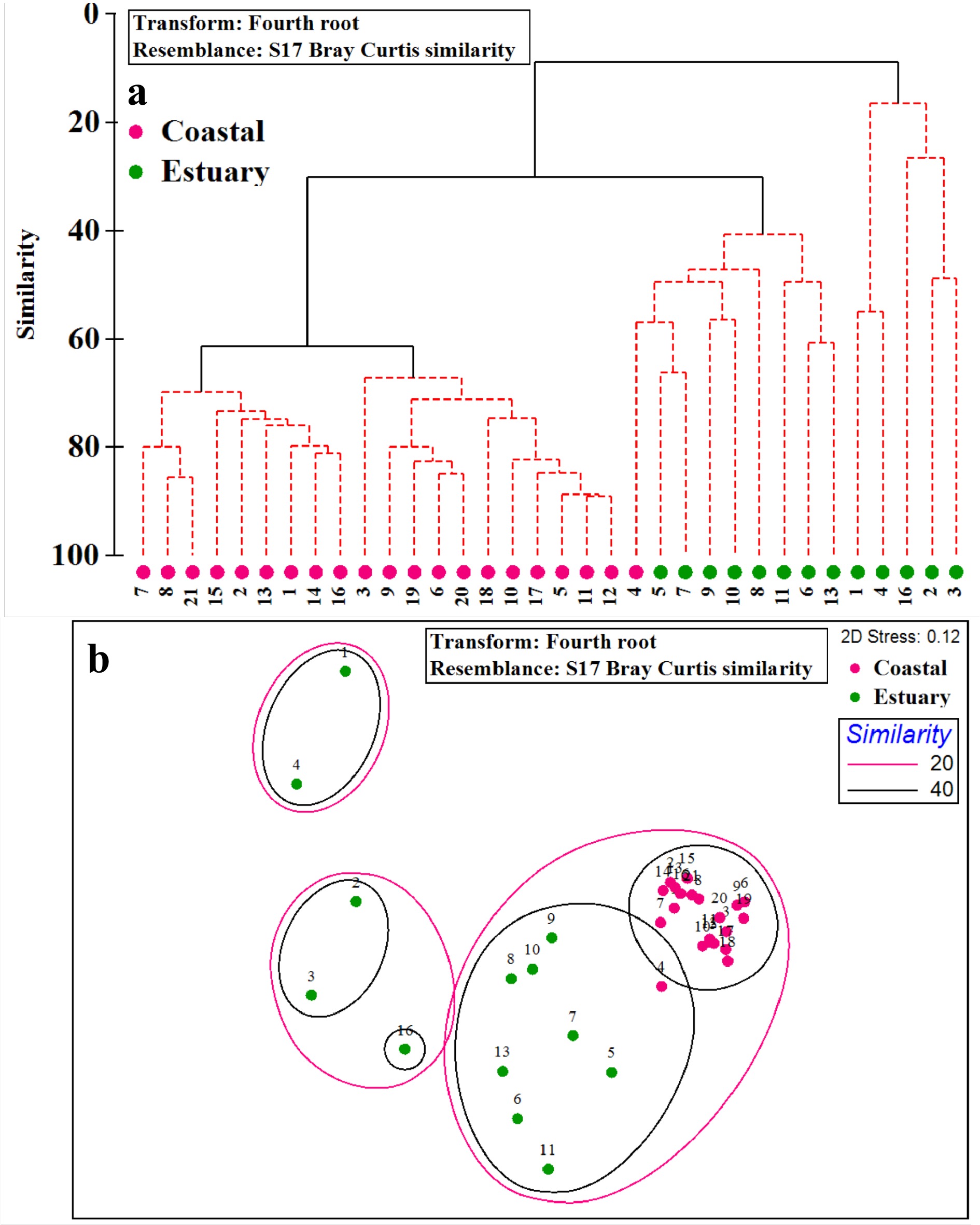


, Available online ,
doi: 10.1007/s13131-024-2383-y
Abstract:
The correct understanding of fish population structure plays a positive role in their fishery management. The dotted gizzard shad, Konosirus punctatus, is widely distributed in the coastal waters of the Northwestern Pacific. With the over-exploitation of economically important fishes, its importance is increasingly prominent. To further examine the population genetic structure of K. punctatus across the Northwestern Pacific, the amplified fragment length polymorphism (AFLP) and the inter-simple sequence repeats (ISSRs) were employed to perform genetic variation analysis. The results showed that the combination of polyacrylamide gel electrophoresis and silver staining can effectively detect genetic variation for K. punctatus populations. The average proportions of polymorphic loci were 46.26% and 87.13% for AFLP and ISSR markers, respectively, and the genetic diversity parameters showed no obvious differences among populations. Both AMOVA and pairwise Fst suggested that there was significant genetic differentiation between Chinese and Japanese populations. All samples also clustered into two clades based on the UPGMA tree by two markers, which indicated significant genetic differentiation among populations. Consistent with the previous studies, there are two highly differentiated groups at the nuclear gene level and they were suggested to be treated as two separate genetic management units. The results of the present study could provide the genetic management strategy for this important economic species.
The correct understanding of fish population structure plays a positive role in their fishery management. The dotted gizzard shad, Konosirus punctatus, is widely distributed in the coastal waters of the Northwestern Pacific. With the over-exploitation of economically important fishes, its importance is increasingly prominent. To further examine the population genetic structure of K. punctatus across the Northwestern Pacific, the amplified fragment length polymorphism (AFLP) and the inter-simple sequence repeats (ISSRs) were employed to perform genetic variation analysis. The results showed that the combination of polyacrylamide gel electrophoresis and silver staining can effectively detect genetic variation for K. punctatus populations. The average proportions of polymorphic loci were 46.26% and 87.13% for AFLP and ISSR markers, respectively, and the genetic diversity parameters showed no obvious differences among populations. Both AMOVA and pairwise Fst suggested that there was significant genetic differentiation between Chinese and Japanese populations. All samples also clustered into two clades based on the UPGMA tree by two markers, which indicated significant genetic differentiation among populations. Consistent with the previous studies, there are two highly differentiated groups at the nuclear gene level and they were suggested to be treated as two separate genetic management units. The results of the present study could provide the genetic management strategy for this important economic species.


, Available online
Abstract:
The exchange of inorganic nutrients at the coastal sediment-water interface (SWI) plays a crucial role in regulating the nutrient budget in overlying water. The related studies mainly focus on the mid to high-latitude regions, leaving a significant gap in the quantitative assessment of nutrient exchange and environmental controls at the SWI in low-latitude coastal regions. We quantitatively assess the exchange of inorganic nutrients at the SWI in three tropical bays (Dongzhai harbor, Xiaohai lagoon, Qinglan harbor). Sediments act as a source of ammonium, phosphate, and silicate, but for nitrate, sediments can be both a source and sink, although with substantial spatial and temporal variations in their fluxes. Labile organic matter is a critical regulator for the fluxes of inorganic nutrients at the SWI. The sedimentary nutrients input with high N/P ratio will alter the nutrient stoichiometry to mitigate the nitrogen limitation in coastal waters. However, the internal sediment release in these tropical bays plays a relative weak role in contributing to the nutrient addition in comparison with the other external nutrient sources including riverine input, submarine groundwater discharge, and atmospheric deposition. According to the global compilation on SWI nutrient fluxes, we propose that water column primary production and external inputs to interpret the variation in exchange and fluxes of nutrients at the SWI in different ecosystems. Such a conceptual understanding of these chain biogeochemical processes involving external nutrient input, primary production, particulate organic matter settling, and the accumulation and release of inorganic nutrients in sediments will be helpful for the scientific-based pollution prevent and control in coastal waters.
The exchange of inorganic nutrients at the coastal sediment-water interface (SWI) plays a crucial role in regulating the nutrient budget in overlying water. The related studies mainly focus on the mid to high-latitude regions, leaving a significant gap in the quantitative assessment of nutrient exchange and environmental controls at the SWI in low-latitude coastal regions. We quantitatively assess the exchange of inorganic nutrients at the SWI in three tropical bays (Dongzhai harbor, Xiaohai lagoon, Qinglan harbor). Sediments act as a source of ammonium, phosphate, and silicate, but for nitrate, sediments can be both a source and sink, although with substantial spatial and temporal variations in their fluxes. Labile organic matter is a critical regulator for the fluxes of inorganic nutrients at the SWI. The sedimentary nutrients input with high N/P ratio will alter the nutrient stoichiometry to mitigate the nitrogen limitation in coastal waters. However, the internal sediment release in these tropical bays plays a relative weak role in contributing to the nutrient addition in comparison with the other external nutrient sources including riverine input, submarine groundwater discharge, and atmospheric deposition. According to the global compilation on SWI nutrient fluxes, we propose that water column primary production and external inputs to interpret the variation in exchange and fluxes of nutrients at the SWI in different ecosystems. Such a conceptual understanding of these chain biogeochemical processes involving external nutrient input, primary production, particulate organic matter settling, and the accumulation and release of inorganic nutrients in sediments will be helpful for the scientific-based pollution prevent and control in coastal waters.


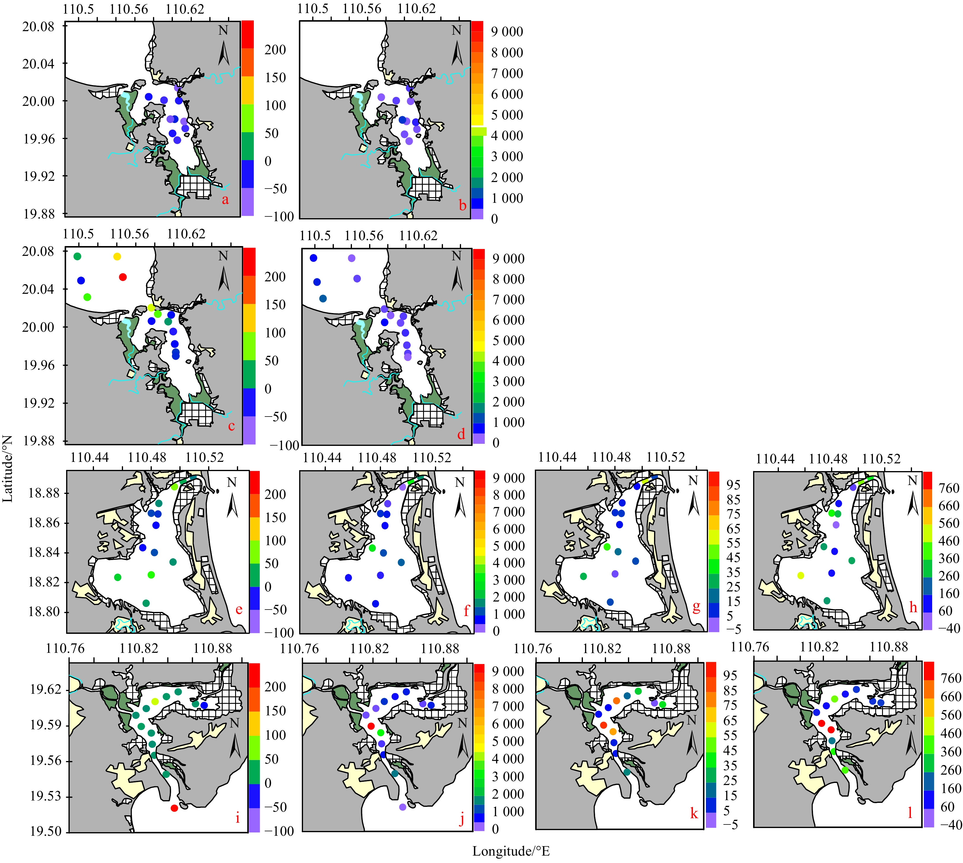
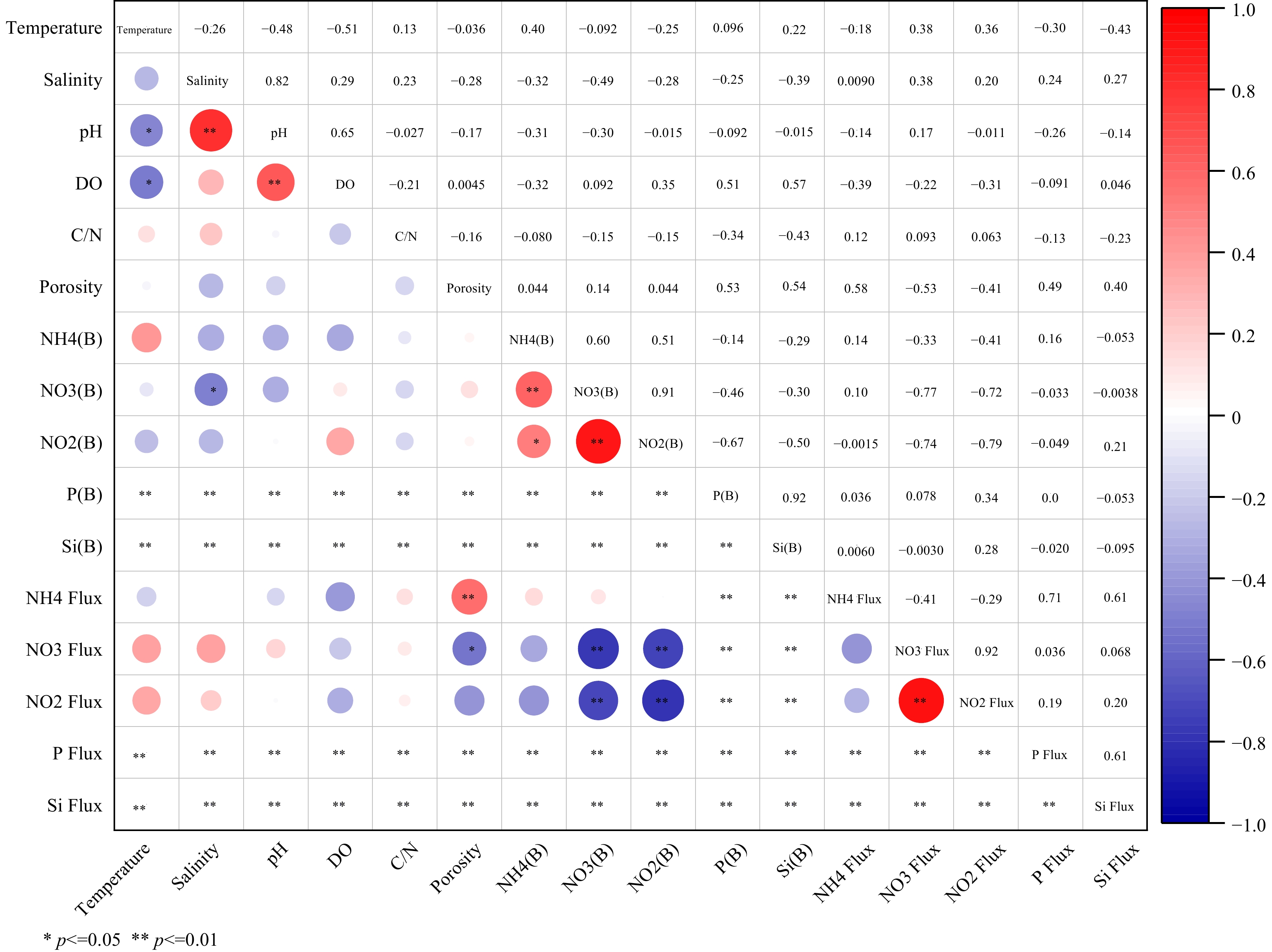

, Available online ,
doi: 10.1007/s13131-024-2303-1
Abstract:
Macrobenthic organisms are commonly employed as biomonitors for environmental risk assessment. In this study, we aimed to investigate the spatial and temporal patterns of the macrobenthic community, which is influenced by environmental factors of sediments and bottom water layer. We sampled a total of 12, 11, 10, and 11 stations in the Shengsi Archipelago during June 2010, August 2010, November 2020, and April 2021 respectively. A total of 124 species of macrobenthos were identified, with polychaetes being the dominant group. The abundance, biomass, and diversity indices exhibited no significant temporal differences. Similarly, biodiversity did not exhibit a clear spatial gradient, likely due to the small study area and the absence of significant differences in key factors such as depth. However, the stations with the lowest biodiversity values consistently appeared in the southwest region, possibly due to the impact of human activities. Significant differences in the macrobenthic community were observed between all months except between June and August, and mollusk Endopleura lubrica and polychaete Sigambra hanaokai were important contributors to these differences according to the results of the Similarity Percentages analysis. Suspended particulate matter (SPM) was identified as the primary driving factors of macrobenthic variability. In summary, the community structure underwent temporal changes influenced by complex current patterns, while biodiversity remained relatively stable. This study contributes to our understanding of the key environmental factors affecting macrobenthic communities and biodiversity. It also provides valuable data support for the long-term monitoring of macrobenthos and the environment in the Shengsi Archipelago.
Macrobenthic organisms are commonly employed as biomonitors for environmental risk assessment. In this study, we aimed to investigate the spatial and temporal patterns of the macrobenthic community, which is influenced by environmental factors of sediments and bottom water layer. We sampled a total of 12, 11, 10, and 11 stations in the Shengsi Archipelago during June 2010, August 2010, November 2020, and April 2021 respectively. A total of 124 species of macrobenthos were identified, with polychaetes being the dominant group. The abundance, biomass, and diversity indices exhibited no significant temporal differences. Similarly, biodiversity did not exhibit a clear spatial gradient, likely due to the small study area and the absence of significant differences in key factors such as depth. However, the stations with the lowest biodiversity values consistently appeared in the southwest region, possibly due to the impact of human activities. Significant differences in the macrobenthic community were observed between all months except between June and August, and mollusk Endopleura lubrica and polychaete Sigambra hanaokai were important contributors to these differences according to the results of the Similarity Percentages analysis. Suspended particulate matter (SPM) was identified as the primary driving factors of macrobenthic variability. In summary, the community structure underwent temporal changes influenced by complex current patterns, while biodiversity remained relatively stable. This study contributes to our understanding of the key environmental factors affecting macrobenthic communities and biodiversity. It also provides valuable data support for the long-term monitoring of macrobenthos and the environment in the Shengsi Archipelago.
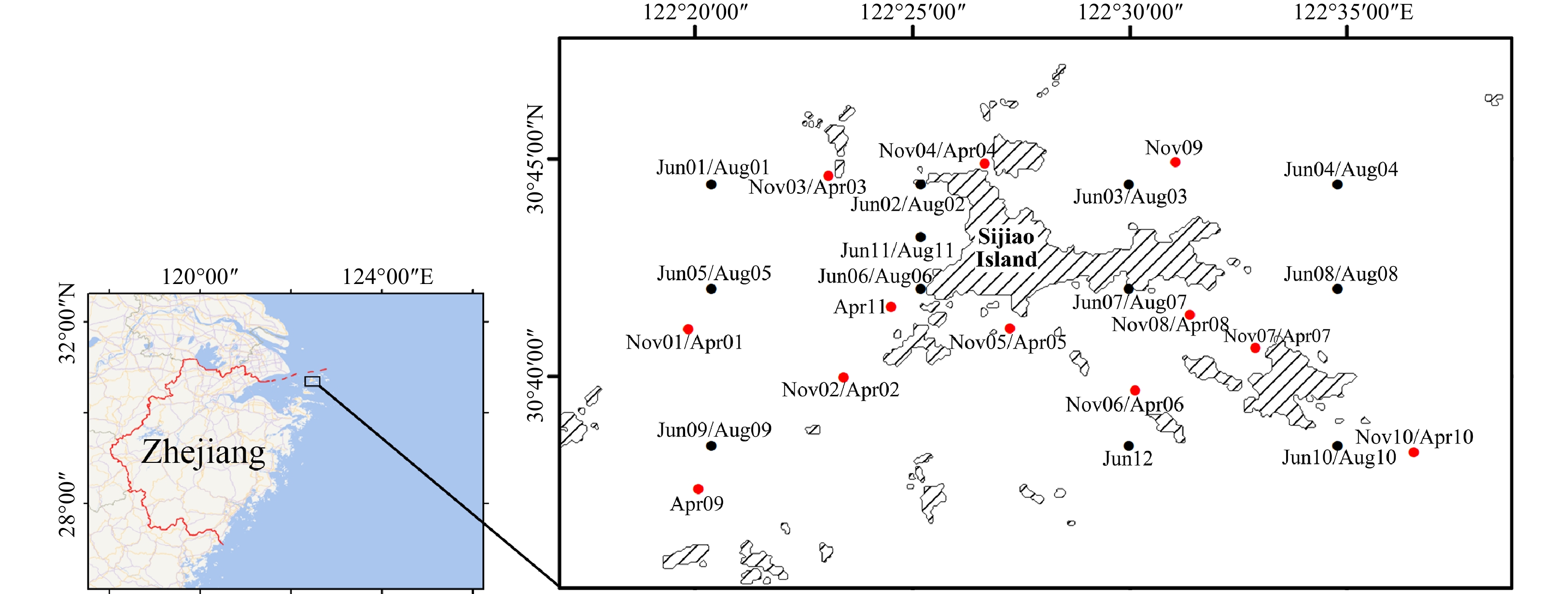

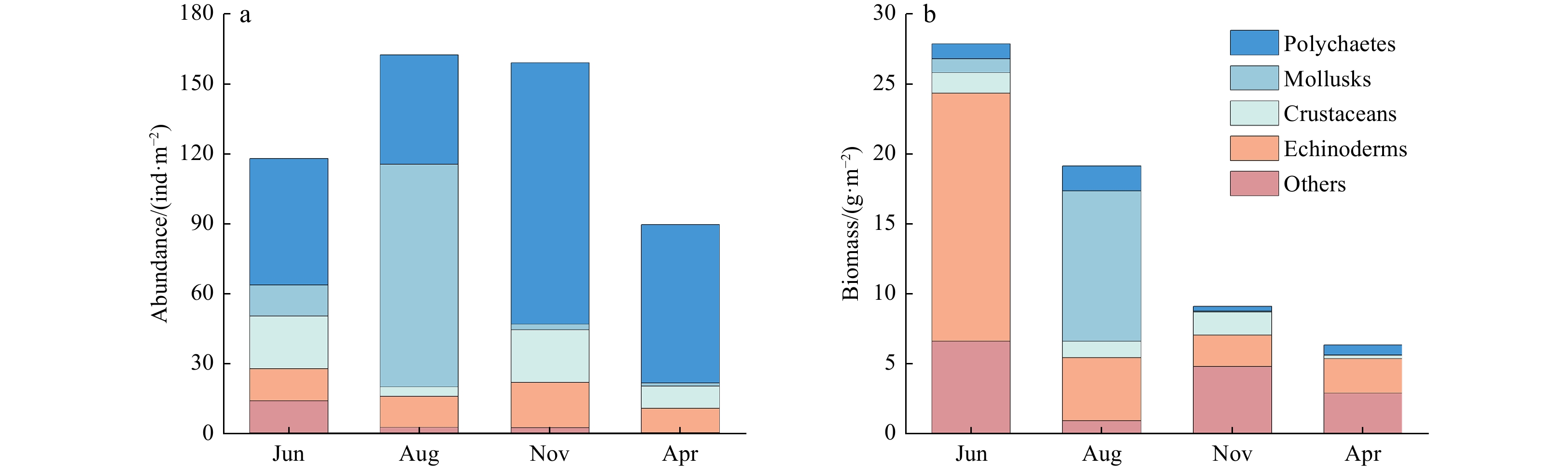
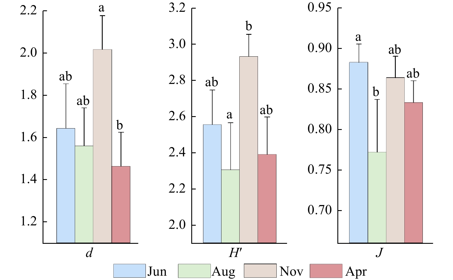
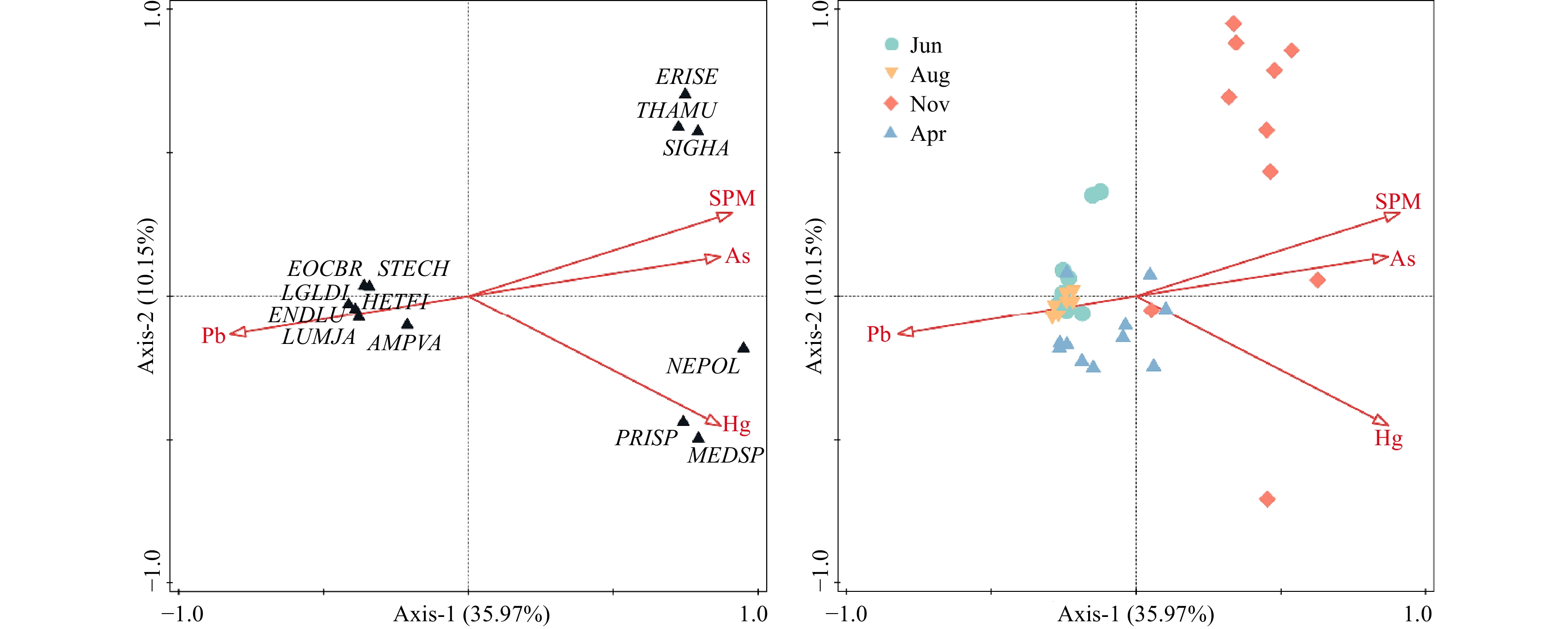
, Available online ,
doi: 10.1007/s13131-022-2131-0
Abstract:
, Available online
Abstract:
Seasonal location and intensity changes in the western Pacific subtropical high (WPSH) are important factors dominating the synoptic weather and the distribution and magnitude of precipitation in the rain belt over East Asia. Therefore, this article delves into the forecast of the western Pacific subtropical high index during typhoon activity by adopting a hybrid deep learning model. Firstly, the predictors, which are the inputs of the model, are analysed based on three characteristics: the first is the statistical discipline of the WPSH index anomalies corresponding to the three types of typhoon paths; the second is the correspondence of distributions between sea surface temperature (SST), 850 hPa zonal wind (u), meridional wind (v), and 500 hPa potential height field; and the third is the numerical sensitivity experiment, which reflects the evident impact of variations in the physical field around the typhoon to the WPSH index. Secondly, the model is repeatedly trained through the backward propagation algorithm to predict the WPSH index using 2011-2018 atmospheric variables as the input of the training set. The model predicts the WPSH index after 6 h, 24 h, 48 h, and 72 h. The validation set using independent data in 2019 is utilized to illustrate the performance. Finally, the model is improved by changing the CNN2D module to the DeCNN module to enhance its ability to predict images. Taking the 2019 Typhoon Lekima as an example, it shows the promising performance of this model to predict the 500 hPa potential height field.
Seasonal location and intensity changes in the western Pacific subtropical high (WPSH) are important factors dominating the synoptic weather and the distribution and magnitude of precipitation in the rain belt over East Asia. Therefore, this article delves into the forecast of the western Pacific subtropical high index during typhoon activity by adopting a hybrid deep learning model. Firstly, the predictors, which are the inputs of the model, are analysed based on three characteristics: the first is the statistical discipline of the WPSH index anomalies corresponding to the three types of typhoon paths; the second is the correspondence of distributions between sea surface temperature (SST), 850 hPa zonal wind (u), meridional wind (v), and 500 hPa potential height field; and the third is the numerical sensitivity experiment, which reflects the evident impact of variations in the physical field around the typhoon to the WPSH index. Secondly, the model is repeatedly trained through the backward propagation algorithm to predict the WPSH index using 2011-2018 atmospheric variables as the input of the training set. The model predicts the WPSH index after 6 h, 24 h, 48 h, and 72 h. The validation set using independent data in 2019 is utilized to illustrate the performance. Finally, the model is improved by changing the CNN2D module to the DeCNN module to enhance its ability to predict images. Taking the 2019 Typhoon Lekima as an example, it shows the promising performance of this model to predict the 500 hPa potential height field.


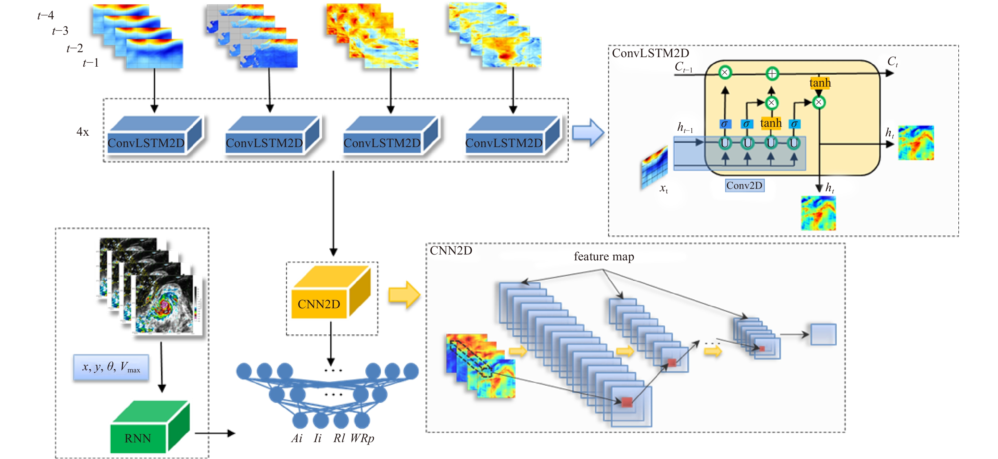


, Available online ,
doi: 10.1007/s13131-020-1589-x
Abstract:
Protease-producing bacteria play key roles in the degradation of organic nitrogen materials in marine sediments. However, their diversity, production of proteases and other extracellular enzymes, even in situ ecological functions remain largely unknown. In this study, we investigated the diversity of cultivable extracellular protease-producing bacteria in the sediments of the Bohai Bay. A total of 109 bacterial isolates were obtained from the sediments of 7 stations. The abundance of cultivable protease-producing bacteria was about 104 CFU/g of sediment in all the samples. Phylogenetic analysis based on 16S rRNA gene sequences classified all the isolates into 14 genera from phyla Proteobacteria, Firmicutes, Bacteroidetes and Actinobacteria, with Pseudoalteromonas (63/109, 57.8%), Bacillus (9/109, 8.2%), Sulfitobacter (8/109, 7.3%) and Salegentibacter (6/109, 5.5%) as the dominant taxa. Enzymatic inhibition tests indicated that all the tested isolates produced serine and/or metalloprotease, with only a small proportion producing cysteine and/or aspartic proteases. Several extracellular enzyme activities, including alginase, lipase, amylase and cellulose, and nitrate reduction were also detected for strains with higher protease activities. According the results, the protease-producing bacteria could also be participate in many biogeochemical processes in marine sediments. Our study broadened understanding and knowledge on the potential ecological functions of protease-producing bacteria in marine sediments.
Protease-producing bacteria play key roles in the degradation of organic nitrogen materials in marine sediments. However, their diversity, production of proteases and other extracellular enzymes, even in situ ecological functions remain largely unknown. In this study, we investigated the diversity of cultivable extracellular protease-producing bacteria in the sediments of the Bohai Bay. A total of 109 bacterial isolates were obtained from the sediments of 7 stations. The abundance of cultivable protease-producing bacteria was about 104 CFU/g of sediment in all the samples. Phylogenetic analysis based on 16S rRNA gene sequences classified all the isolates into 14 genera from phyla Proteobacteria, Firmicutes, Bacteroidetes and Actinobacteria, with Pseudoalteromonas (63/109, 57.8%), Bacillus (9/109, 8.2%), Sulfitobacter (8/109, 7.3%) and Salegentibacter (6/109, 5.5%) as the dominant taxa. Enzymatic inhibition tests indicated that all the tested isolates produced serine and/or metalloprotease, with only a small proportion producing cysteine and/or aspartic proteases. Several extracellular enzyme activities, including alginase, lipase, amylase and cellulose, and nitrate reduction were also detected for strains with higher protease activities. According the results, the protease-producing bacteria could also be participate in many biogeochemical processes in marine sediments. Our study broadened understanding and knowledge on the potential ecological functions of protease-producing bacteria in marine sediments.
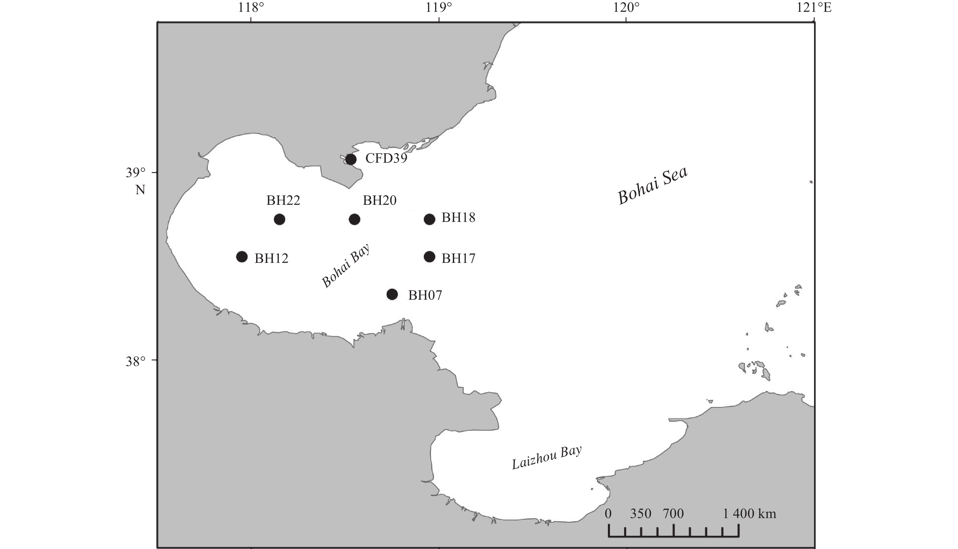

Display Method:
2024, 43(12): 1-12.
doi: 10.1007/s13131-024-2365-0
Abstract:
We introduce a new method, the piecewise Reynolds mean (PREM), for decomposing the flow velocity into the mean-flow and eddy-flow parts in the time domain for subsequent calculation of the mean flow kinetic energy (MKE) and eddy kinetic energy (EKE). Compared with conventional methods like the Reynolds mean and running mean (RUM), PREM has the advantage of exact balance between the MKE and EKE, without the additional residual kinetic energy (RKE), while retaining time-dependent mean-flow. It is mathematically simple and computationally lightweight, depending on a pre-defined separation scale for the mean-flow and eddies. Based on satellite observations and the separation scale of 1 year, we compare PREM with RUM, as well as another newly proposed method, the eddy detection and extraction (EDEX). The latter is based on objective identification of mesoscale eddies and eddy anomaly extraction algorithms, and is therefore only suitable for mesoscale eddy energetics, but independent of separation scales. It is shown that compared with RUM, PREM gives larger mean EKE and stronger interannual variability. In strong-current and eddy-rich regions, the two methods differ the most (max: Kuroshio Extension, root-mean-sqaure-difference = 60.3 J/m3); but in areas with weak current and eddy, the difference accounts for the largest fraction of total EKE (max: south of the Aleutian Islands, 208%). EKE estimated by the two methods is out of phase (min correlation coefficient = 0.38). The mean EKE and standard deviation from the EDEX method resemble the PREM with 1-year separation scale, but is generally smaller in magnitude.
We introduce a new method, the piecewise Reynolds mean (PREM), for decomposing the flow velocity into the mean-flow and eddy-flow parts in the time domain for subsequent calculation of the mean flow kinetic energy (MKE) and eddy kinetic energy (EKE). Compared with conventional methods like the Reynolds mean and running mean (RUM), PREM has the advantage of exact balance between the MKE and EKE, without the additional residual kinetic energy (RKE), while retaining time-dependent mean-flow. It is mathematically simple and computationally lightweight, depending on a pre-defined separation scale for the mean-flow and eddies. Based on satellite observations and the separation scale of 1 year, we compare PREM with RUM, as well as another newly proposed method, the eddy detection and extraction (EDEX). The latter is based on objective identification of mesoscale eddies and eddy anomaly extraction algorithms, and is therefore only suitable for mesoscale eddy energetics, but independent of separation scales. It is shown that compared with RUM, PREM gives larger mean EKE and stronger interannual variability. In strong-current and eddy-rich regions, the two methods differ the most (max: Kuroshio Extension, root-mean-sqaure-difference = 60.3 J/m3); but in areas with weak current and eddy, the difference accounts for the largest fraction of total EKE (max: south of the Aleutian Islands, 208%). EKE estimated by the two methods is out of phase (min correlation coefficient = 0.38). The mean EKE and standard deviation from the EDEX method resemble the PREM with 1-year separation scale, but is generally smaller in magnitude.
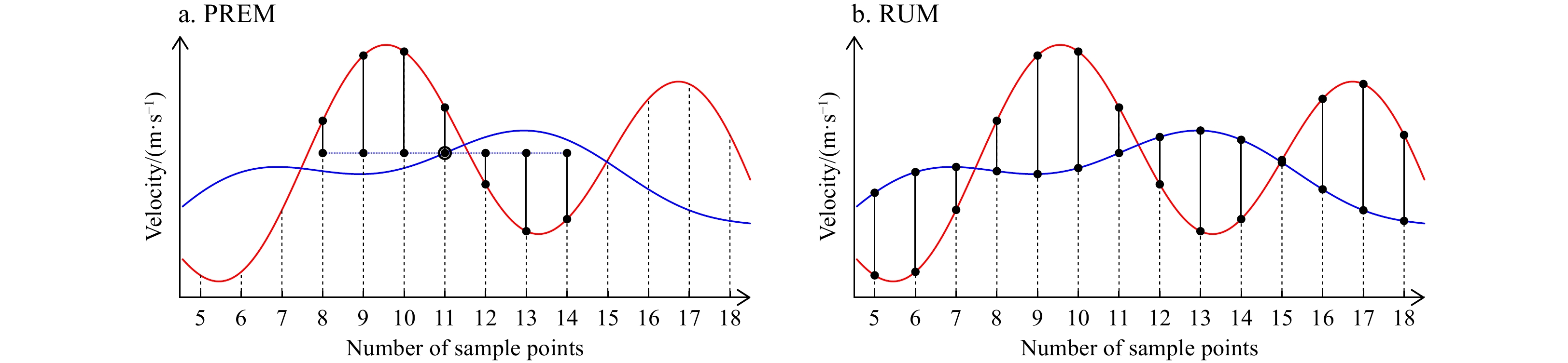


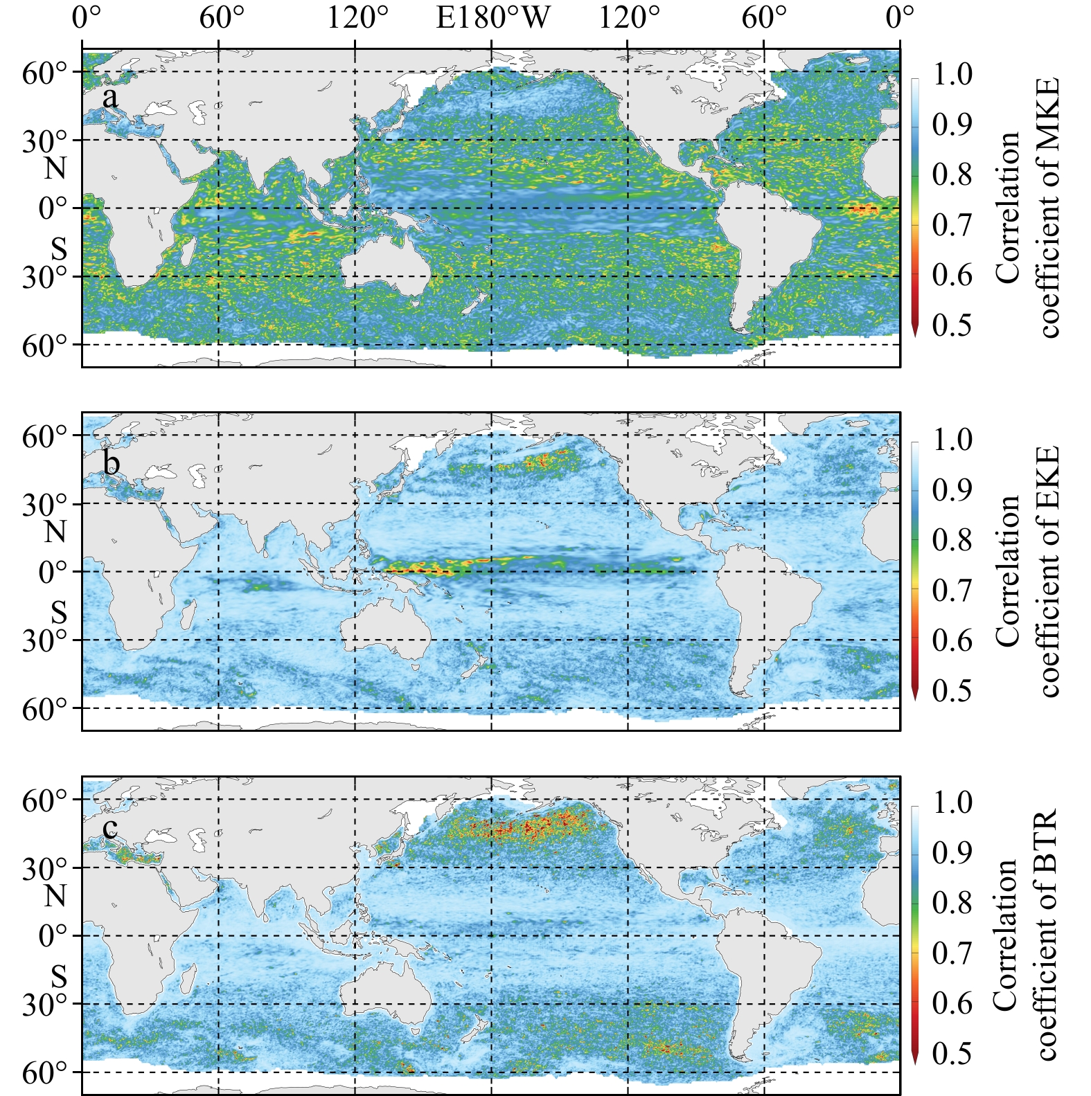

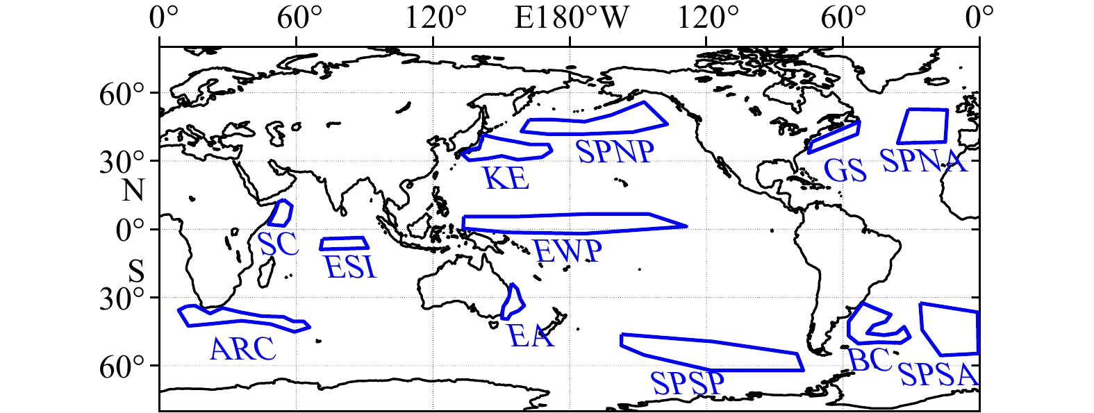
2024, 43(12): 13-33.
doi: 10.1007/s13131-024-2450-4
Abstract:
Accurate significant wave height (SWH) prediction is essential for the development and utilization of wave energy. Deep learning methods such as recurrent and convolutional neural networks have achieved good results in SWH forecasting. However, these methods do not adapt well to dynamic seasonal variations in wave data. In this study, we propose a novel method—the spatiotemporal dynamic graph (STDG) neural network. This method predicts the SWH of multiple nodes based on dynamic graph modeling and multi-characteristic fusion. First, considering the dynamic seasonal variations in the wave direction over time, the network models wave dynamic spatial dependencies from long- and short-term pattern perspectives. Second, to correlate multiple characteristics with SWH, the network introduces a cross-characteristic transformer to effectively fuse multiple characteristics. Finally, we conducted experiments on two datasets from the South China Sea and East China Sea to validate the proposed method and compared it with five prediction methods in the three categories. The experimental results show that the proposed method achieves the best performance at all predictive scales and has greater advantages for extreme value prediction. Furthermore, an analysis of the dynamic graph shows that the proposed method captures the seasonal variation mechanism of the waves.
Accurate significant wave height (SWH) prediction is essential for the development and utilization of wave energy. Deep learning methods such as recurrent and convolutional neural networks have achieved good results in SWH forecasting. However, these methods do not adapt well to dynamic seasonal variations in wave data. In this study, we propose a novel method—the spatiotemporal dynamic graph (STDG) neural network. This method predicts the SWH of multiple nodes based on dynamic graph modeling and multi-characteristic fusion. First, considering the dynamic seasonal variations in the wave direction over time, the network models wave dynamic spatial dependencies from long- and short-term pattern perspectives. Second, to correlate multiple characteristics with SWH, the network introduces a cross-characteristic transformer to effectively fuse multiple characteristics. Finally, we conducted experiments on two datasets from the South China Sea and East China Sea to validate the proposed method and compared it with five prediction methods in the three categories. The experimental results show that the proposed method achieves the best performance at all predictive scales and has greater advantages for extreme value prediction. Furthermore, an analysis of the dynamic graph shows that the proposed method captures the seasonal variation mechanism of the waves.
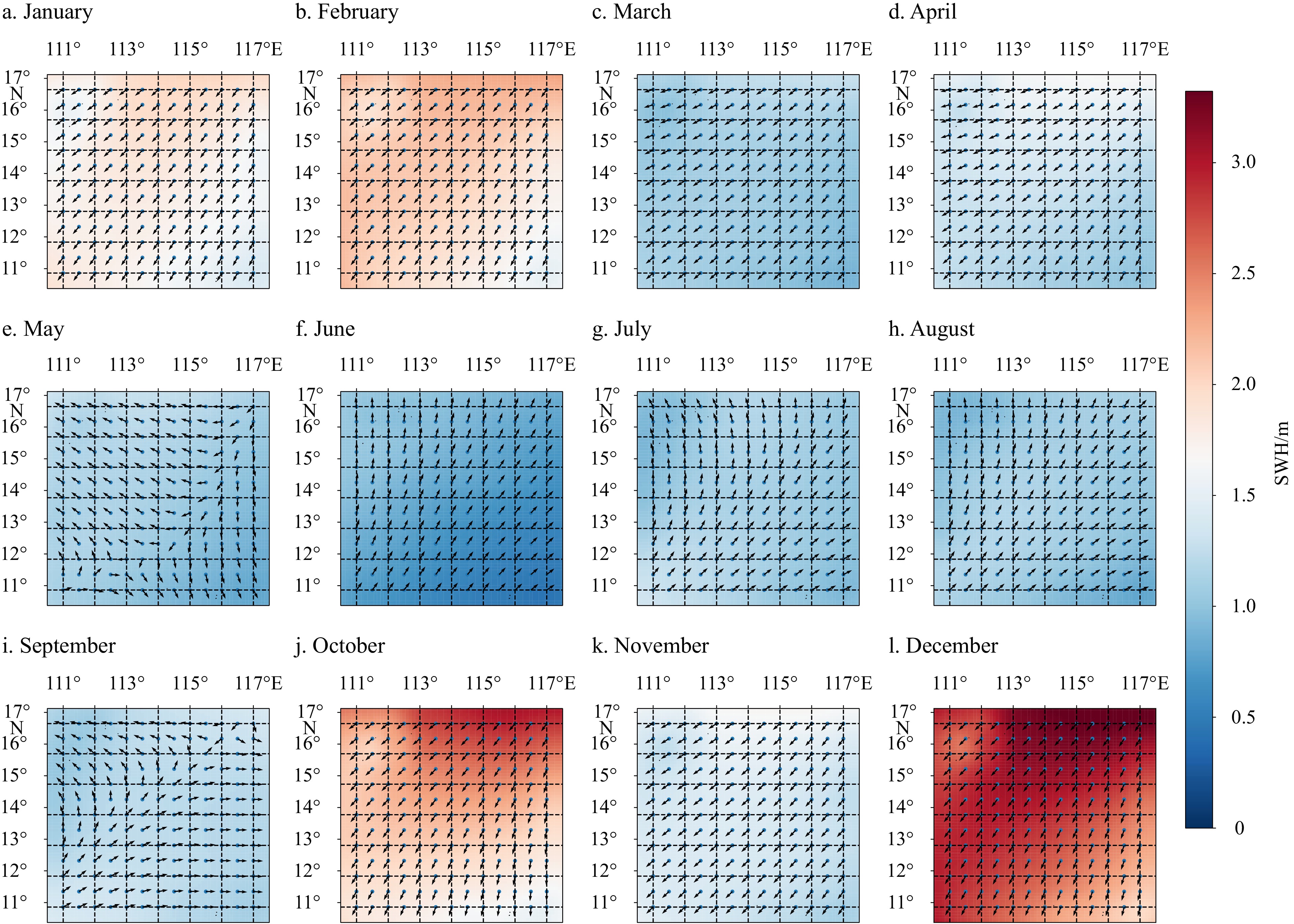
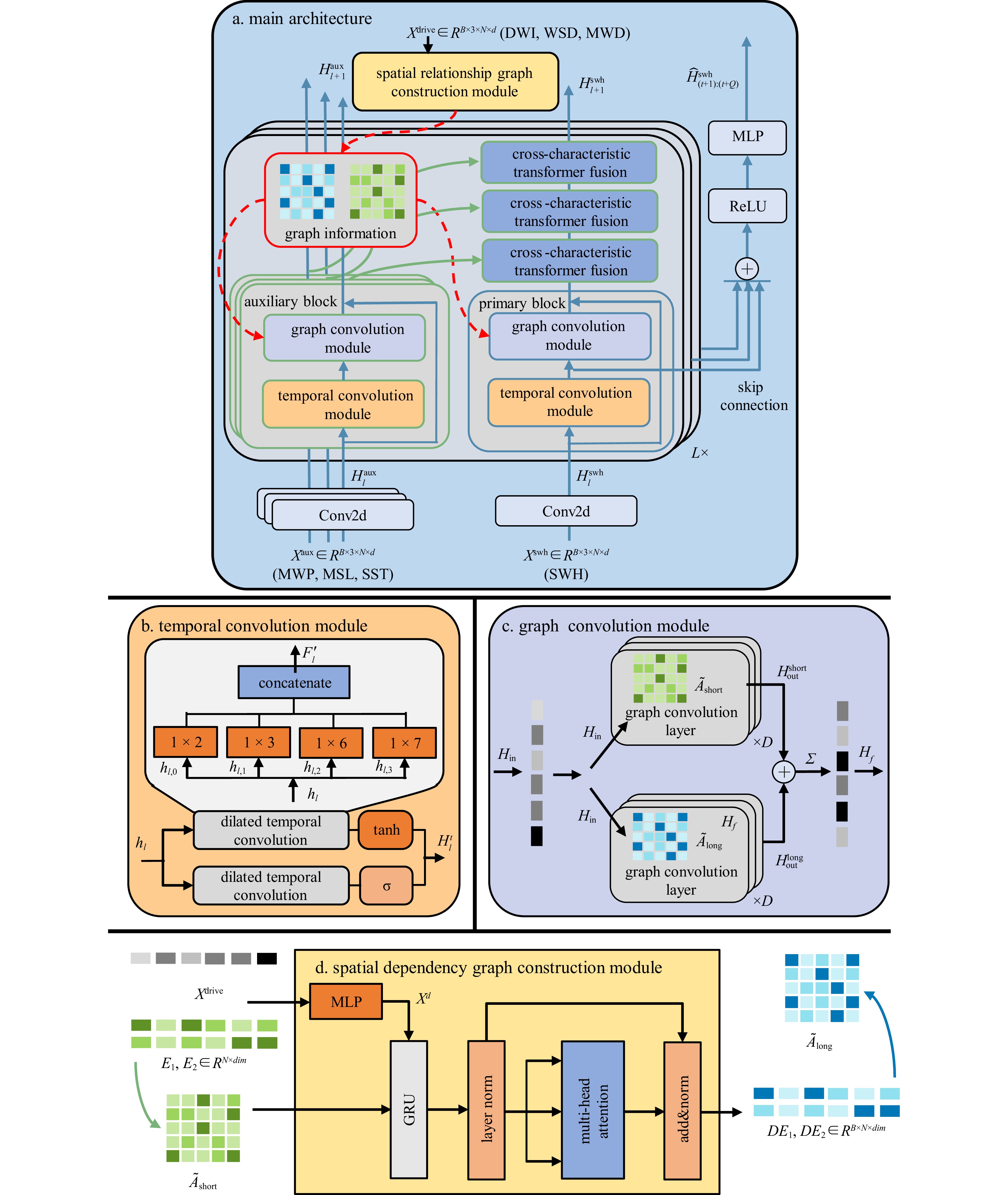
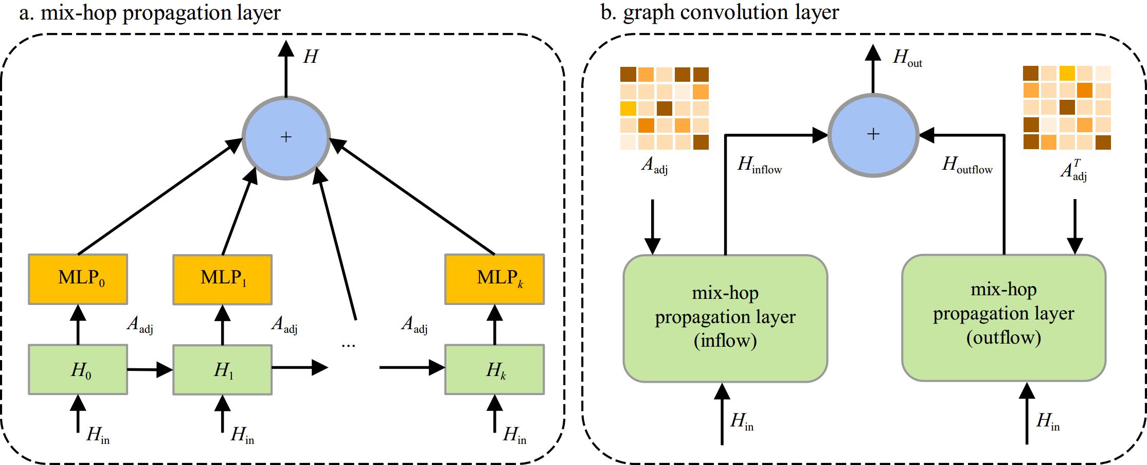
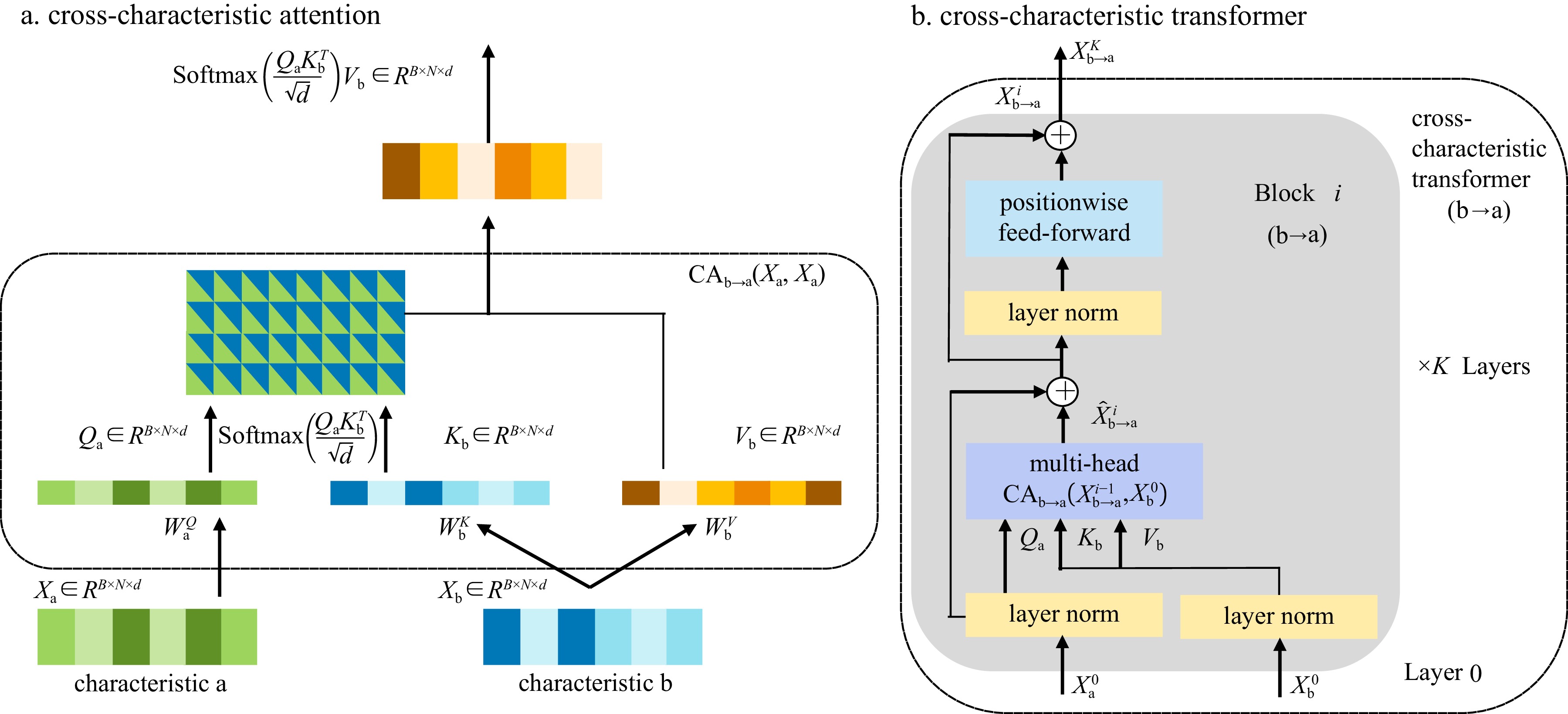
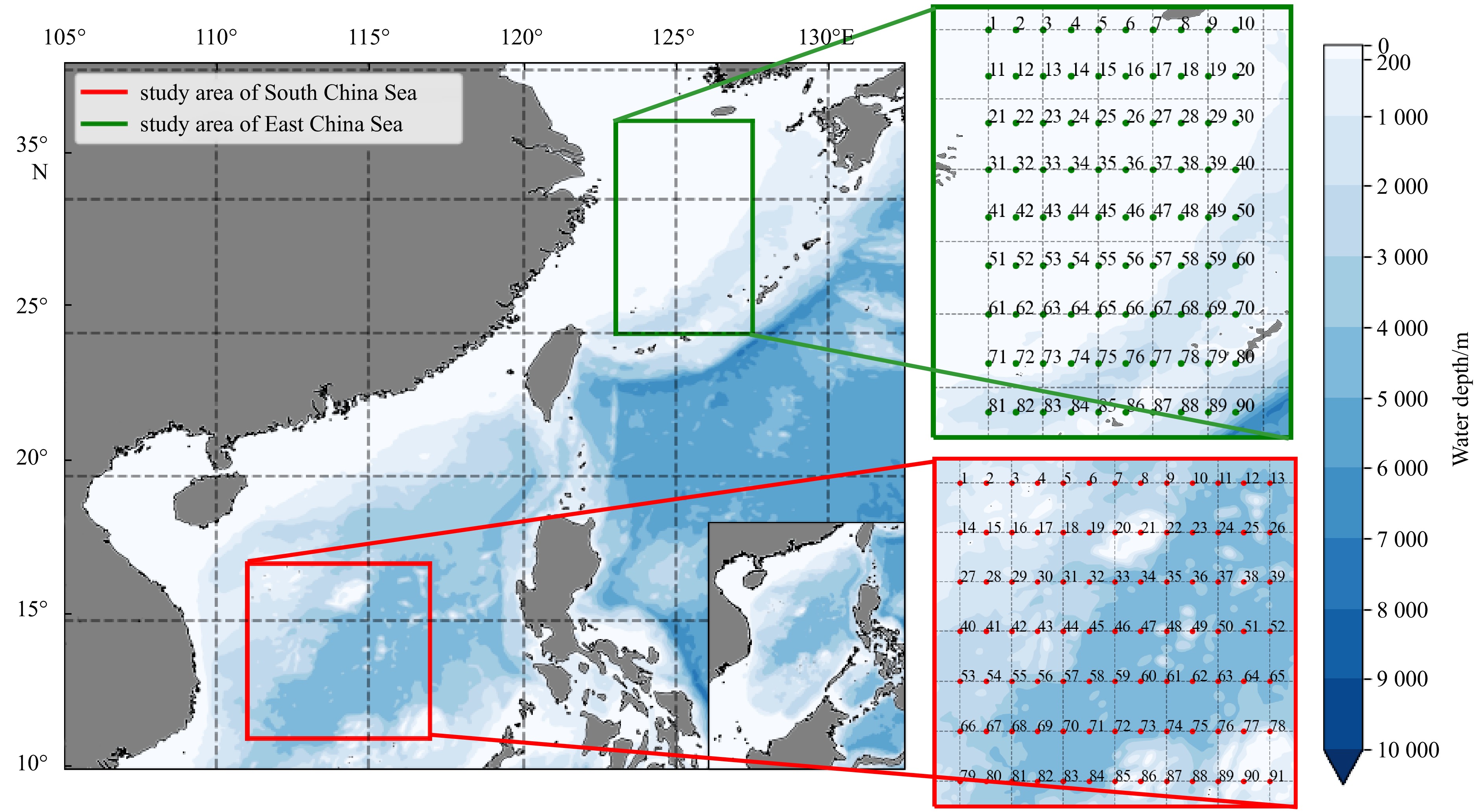
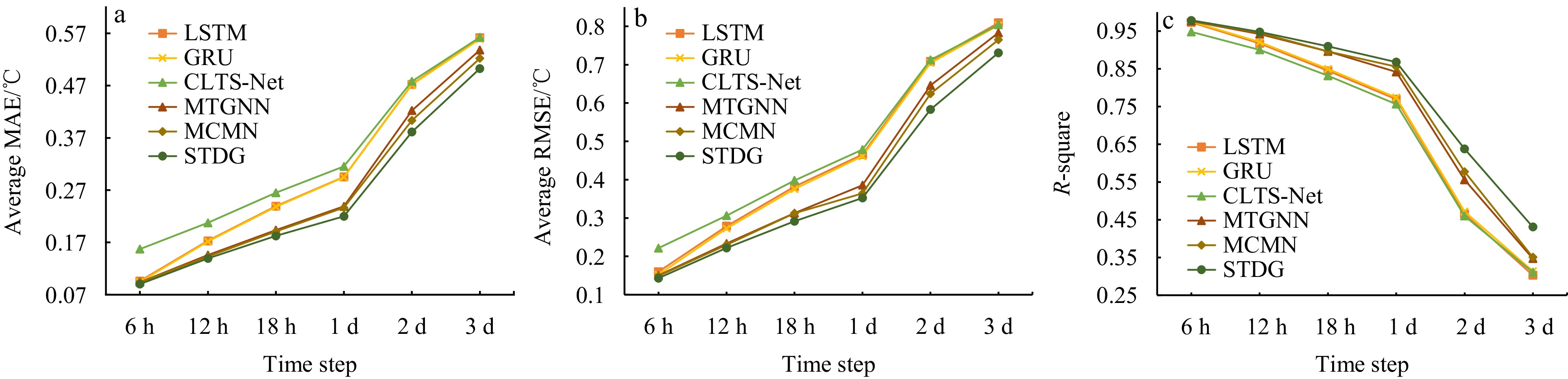
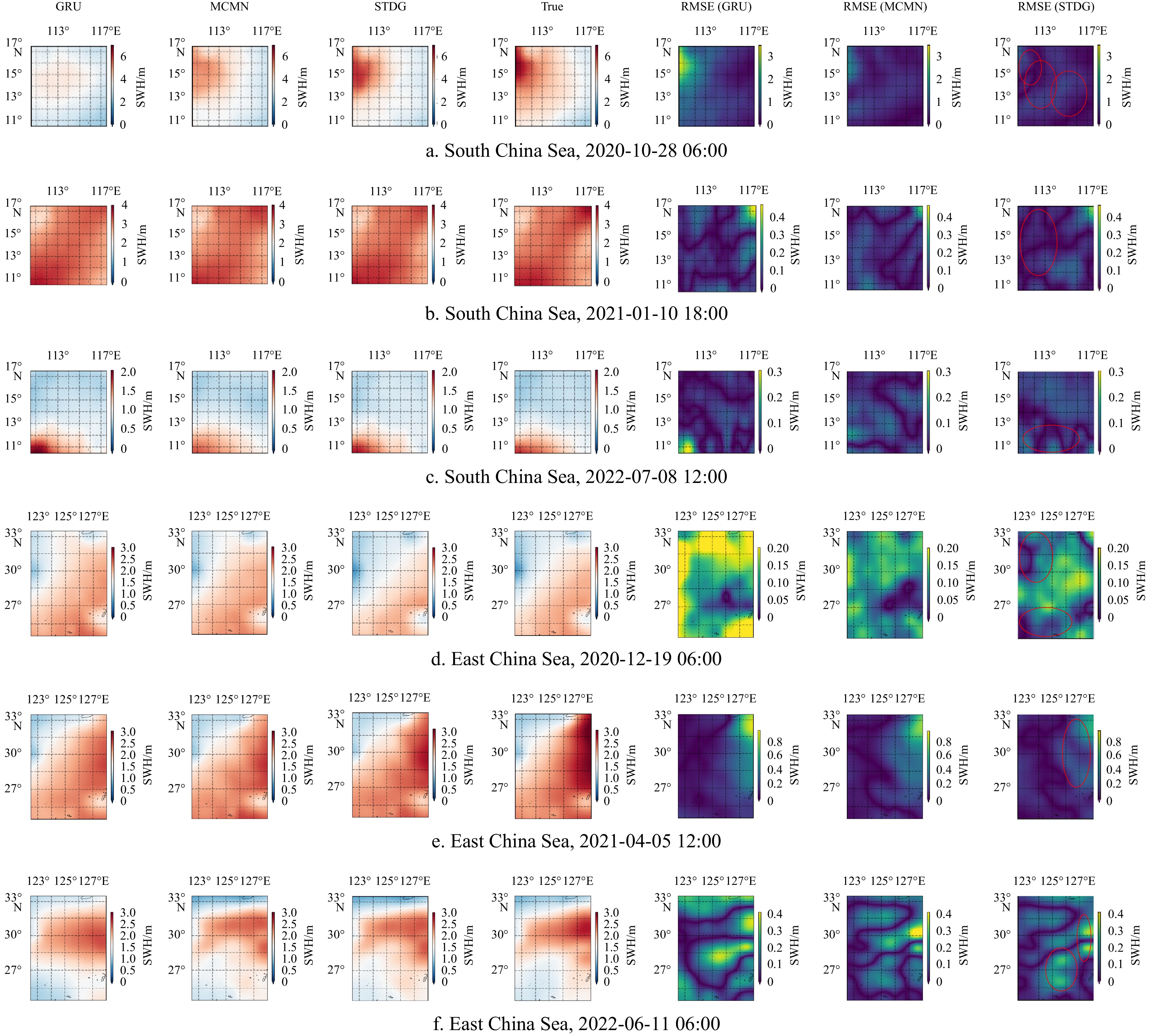
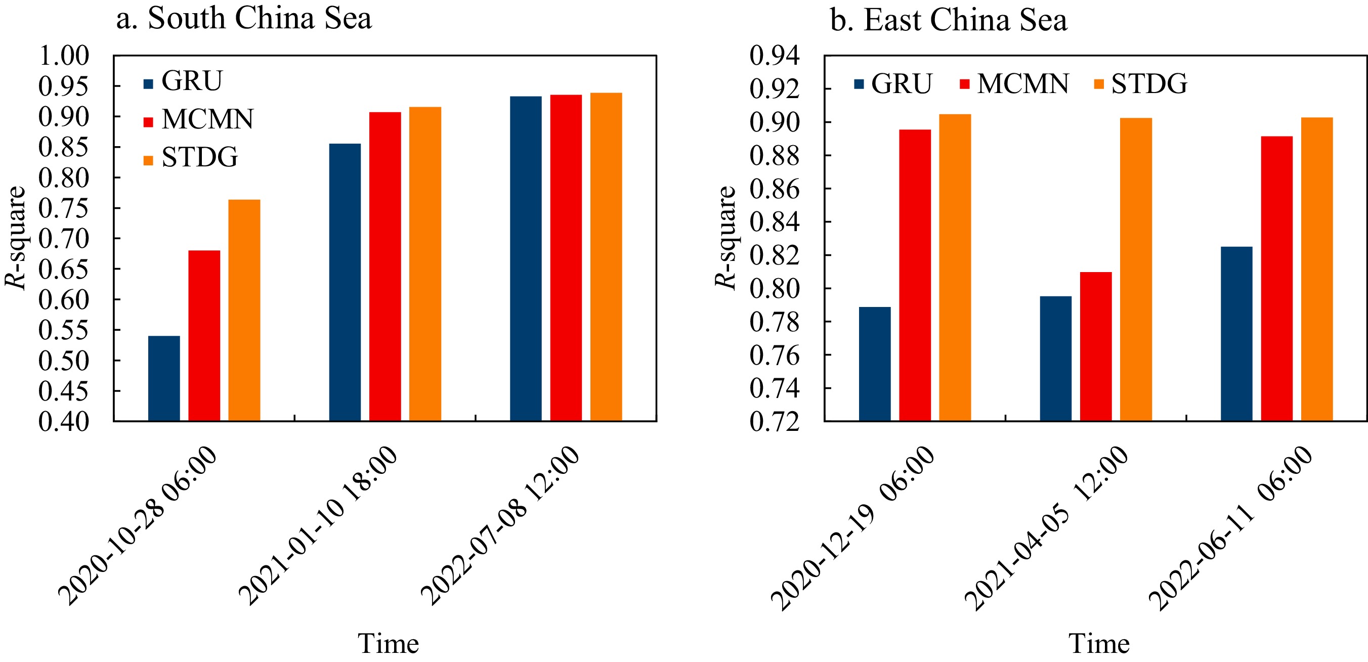
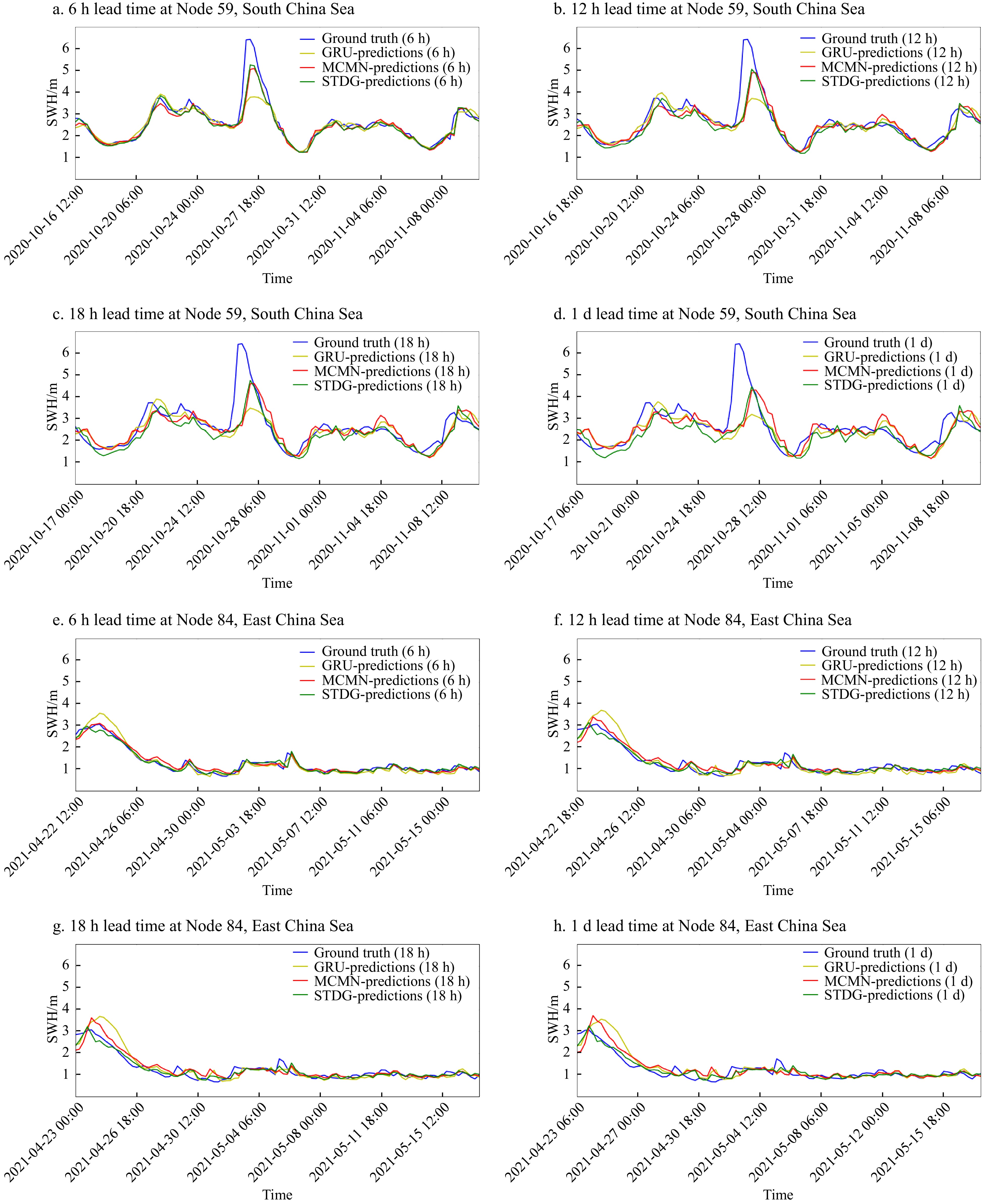


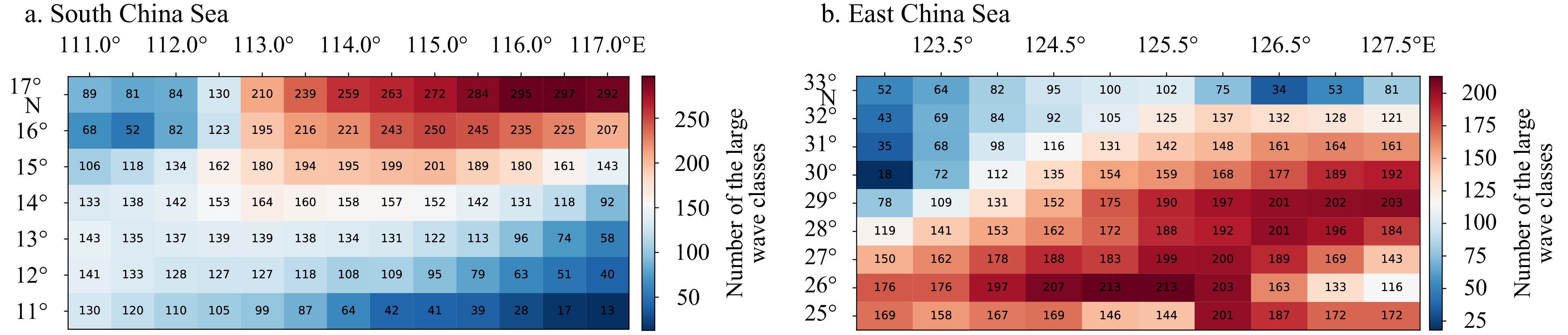
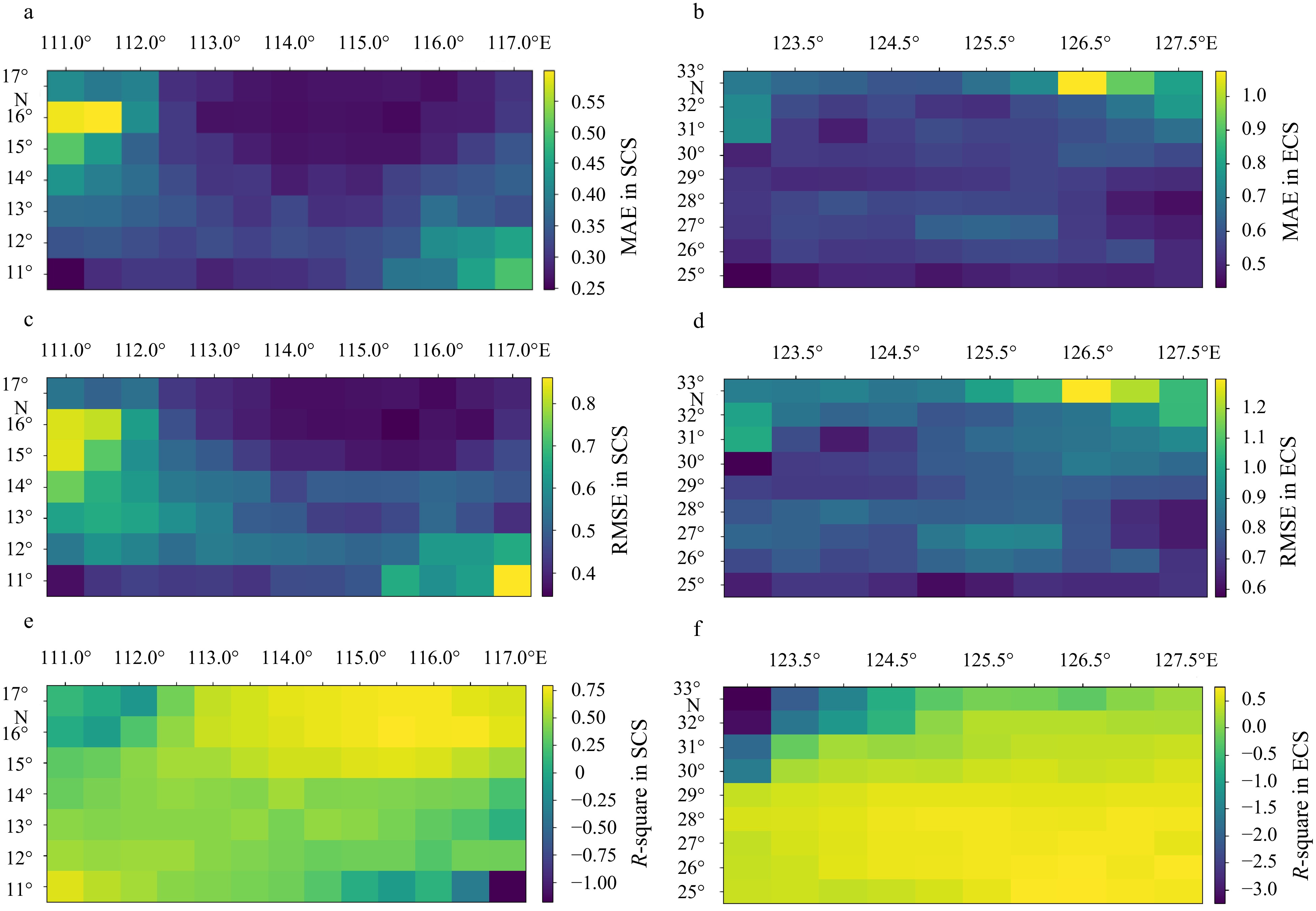
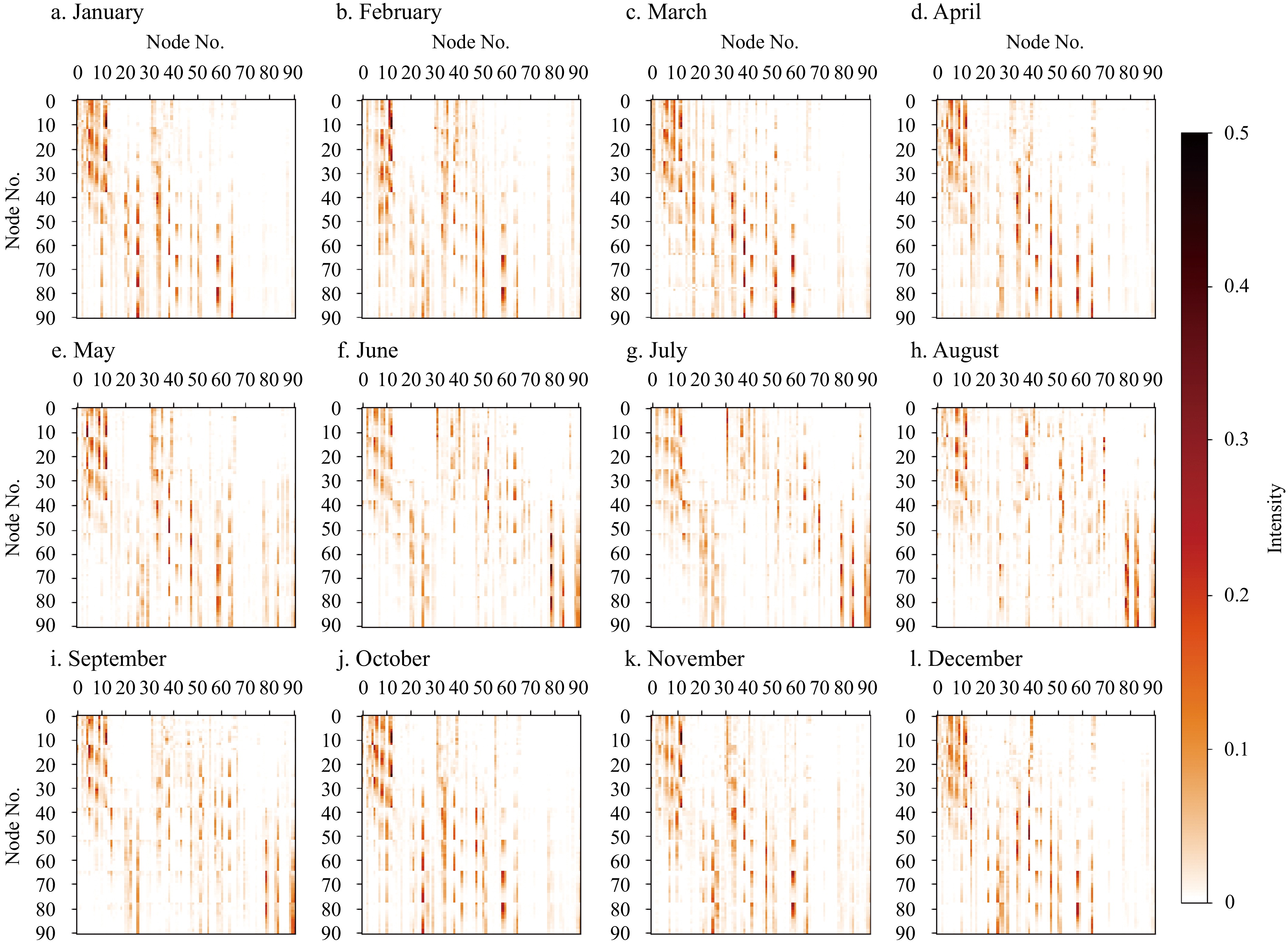


2024, 43(12): 34-46.
doi: 10.1007/s13131-024-2395-7
Abstract:
Over the past two decades, numerous countries have actively participated in the International Argo Program, working toward the global “OneArgo” goal. China’s Argo program has deployed over 500 autonomous profiling floats in the Indo-Pacific, with 55 Beidou (BD) floats, equipped with the Beidou satellite communication system, currently operational. During the operation of the BD float network, we found that in addition to the limitation of floats battery, the loss may also be caused by communication loss due to the floats escaping from the Beidou-2’s short message coverage. In this study, float trajectories are simulated using velocity fields from an eddy-resolved resolution Estimating the Circulation and Climate of the Ocean, Phase Ⅱ (ECCO2) model and a Lagrangian particle tracking model programmed to represent the vertical motions of profiling floats. The simulations can help to explore both the representativeness and the predictability of profiling float displacements. By deploying a large number of synthetic floats in the Lagrangian particle tracking system, we construct probability density functions (PDFs) of the simulated-float trajectory among key oceans, for example, a joint region of East Indian−South China Sea−Northwest Pacific Ocean (5°–40°N, 70°–140°E), which is generally similar to the location of the present BD float network. These statistics can help to estimate the chance of floats drifting into shallow seas (such as the East China Sea) and out of the coverage of the Beidou satellite communication. With this knowledge changes to the future China’s Argo observing system could be made.
Over the past two decades, numerous countries have actively participated in the International Argo Program, working toward the global “OneArgo” goal. China’s Argo program has deployed over 500 autonomous profiling floats in the Indo-Pacific, with 55 Beidou (BD) floats, equipped with the Beidou satellite communication system, currently operational. During the operation of the BD float network, we found that in addition to the limitation of floats battery, the loss may also be caused by communication loss due to the floats escaping from the Beidou-2’s short message coverage. In this study, float trajectories are simulated using velocity fields from an eddy-resolved resolution Estimating the Circulation and Climate of the Ocean, Phase Ⅱ (ECCO2) model and a Lagrangian particle tracking model programmed to represent the vertical motions of profiling floats. The simulations can help to explore both the representativeness and the predictability of profiling float displacements. By deploying a large number of synthetic floats in the Lagrangian particle tracking system, we construct probability density functions (PDFs) of the simulated-float trajectory among key oceans, for example, a joint region of East Indian−South China Sea−Northwest Pacific Ocean (5°–40°N, 70°–140°E), which is generally similar to the location of the present BD float network. These statistics can help to estimate the chance of floats drifting into shallow seas (such as the East China Sea) and out of the coverage of the Beidou satellite communication. With this knowledge changes to the future China’s Argo observing system could be made.


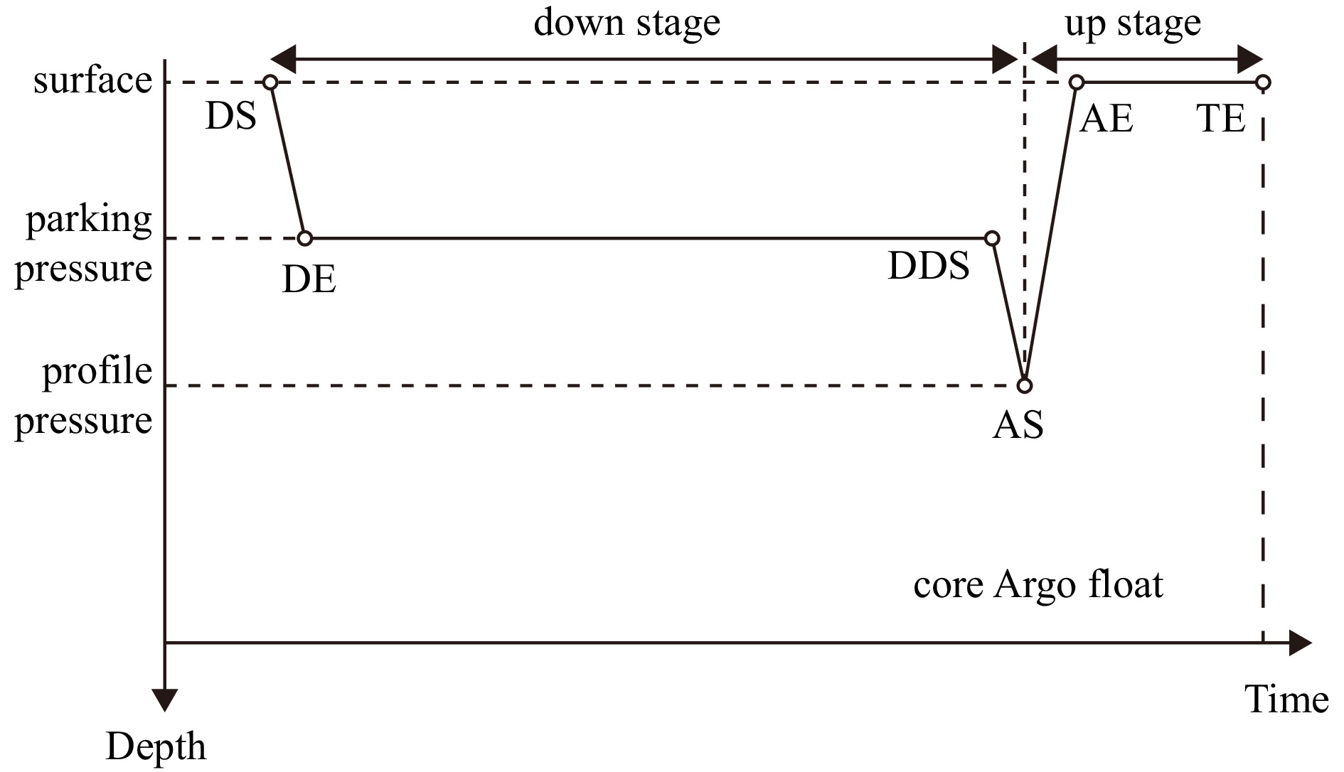


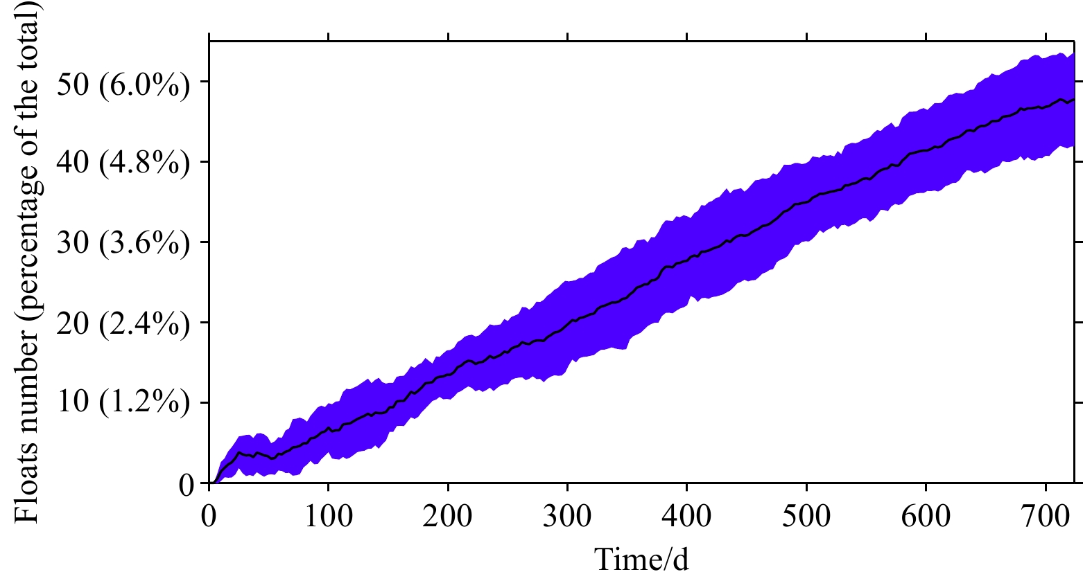


2024, 43(12): 58-65.
doi: 10.1007/s13131-024-2415-7
Abstract:
Aquaculture, as the fastest-growing food production sector in the world, is becoming an increasingly nonnegligible source of greenhouse gas emissions. Despite this, there has been limited research on nitrous oxide (N2O) emission from marine aquaculture in China, where more marine aquaculture occurs than anywhere else, globally. We estimated N2O emissions (E) from marine mariculture of 10 fish and 6 crustacean species in China from 2003 to 2022 using production data from the China Fishery Statistical Yearbook (2004–2023), and data for feed conversion rates and types from the literature. From 2003, marine aquaculture production, the annual N2O emissions (EA), and the annual N2O emissions per unit of aquaculture area (EIA) trend upward. The EA of fish culture was lower than that of crustaceans, but the EIA of fish culture was generally higher. Sea bass (0.308 Tg/a, in terms of N) and white shrimp (0.945 Tg/a, in terms of N) had the highest average EA among fish and crustacean cultures, respectively. The highest average EA from fish and crustacean were both Guangdong Province (fish: 0.248 Tg, crustacean: 0.547 Tg), and the highest sea area were both the South China Sea (fish: 0.316 Tg, crustacean: 1.082 Tg); the highest average EIA for fish and crustacean were Tianjin City [35.40 t/(hm2·a)] and Guangxi Zhuang Autonomous Region [19.83 t/(hm2·a)], respectively, and the highest sea areas were both the South China Sea (fish: 0.316 Tg, crustacean: 1.082 Tg). These analyses provide baseline data for a greenhouse gas emissions inventory for China, based on an interpretation of them, we provide recommendations for reducing N2O emissions in marine fish and crustacean culture.
Aquaculture, as the fastest-growing food production sector in the world, is becoming an increasingly nonnegligible source of greenhouse gas emissions. Despite this, there has been limited research on nitrous oxide (N2O) emission from marine aquaculture in China, where more marine aquaculture occurs than anywhere else, globally. We estimated N2O emissions (E) from marine mariculture of 10 fish and 6 crustacean species in China from 2003 to 2022 using production data from the China Fishery Statistical Yearbook (2004–2023), and data for feed conversion rates and types from the literature. From 2003, marine aquaculture production, the annual N2O emissions (EA), and the annual N2O emissions per unit of aquaculture area (EIA) trend upward. The EA of fish culture was lower than that of crustaceans, but the EIA of fish culture was generally higher. Sea bass (0.308 Tg/a, in terms of N) and white shrimp (0.945 Tg/a, in terms of N) had the highest average EA among fish and crustacean cultures, respectively. The highest average EA from fish and crustacean were both Guangdong Province (fish: 0.248 Tg, crustacean: 0.547 Tg), and the highest sea area were both the South China Sea (fish: 0.316 Tg, crustacean: 1.082 Tg); the highest average EIA for fish and crustacean were Tianjin City [35.40 t/(hm2·a)] and Guangxi Zhuang Autonomous Region [19.83 t/(hm2·a)], respectively, and the highest sea areas were both the South China Sea (fish: 0.316 Tg, crustacean: 1.082 Tg). These analyses provide baseline data for a greenhouse gas emissions inventory for China, based on an interpretation of them, we provide recommendations for reducing N2O emissions in marine fish and crustacean culture.


2024, 43(12): 66-74.
doi: 10.1007/s13131-024-2423-7
Abstract:
Particle size is an important characteristic of suspended matter, and it contains crucial information about the deposition process. Suspended particle samples in the water mixing zone of the Changjiang River Estuary were collected in December 2016. Untreated original grain size and the decentralized grain size of the suspended particles were measured via a laser particle size analyzer. Morphological characteristics and the chemical composition of the suspended particles were also studied systematically using a scanning electron microscope (SEM) with an energy dispersive X-ray spectrometer (EDS). Then, the flocculation and sedimentation of suspended matter in the water mixing zone were explored by combining them with the water mixing processes in the estuary. The average particle size of suspended matter in the mixing zone of the Changjiang River Estuary ranges from Ф5.73 to Ф7.98. The particle size distribution pattern is an abnormal model with a mainly unimodal pattern. In the freshwater area that was dominated by runoff, the suspended matter is mainly composed of fine particles, the settling velocity is slow, and the flocculation is weak. Floc particles were often seen in the mixing zone, with the flocs having a relatively large particle size, a low density and a loose structure appearing at the weak mixing zone; the flocs had a compacted structure in most areas of the mixing zone. The changes of suspended particle size in the estuarine mixing zone promote the settling and deposition of suspended matter, which has an important influence on the bed geomorphology and preservation of the fine suspended particles in the estuary.
Particle size is an important characteristic of suspended matter, and it contains crucial information about the deposition process. Suspended particle samples in the water mixing zone of the Changjiang River Estuary were collected in December 2016. Untreated original grain size and the decentralized grain size of the suspended particles were measured via a laser particle size analyzer. Morphological characteristics and the chemical composition of the suspended particles were also studied systematically using a scanning electron microscope (SEM) with an energy dispersive X-ray spectrometer (EDS). Then, the flocculation and sedimentation of suspended matter in the water mixing zone were explored by combining them with the water mixing processes in the estuary. The average particle size of suspended matter in the mixing zone of the Changjiang River Estuary ranges from Ф5.73 to Ф7.98. The particle size distribution pattern is an abnormal model with a mainly unimodal pattern. In the freshwater area that was dominated by runoff, the suspended matter is mainly composed of fine particles, the settling velocity is slow, and the flocculation is weak. Floc particles were often seen in the mixing zone, with the flocs having a relatively large particle size, a low density and a loose structure appearing at the weak mixing zone; the flocs had a compacted structure in most areas of the mixing zone. The changes of suspended particle size in the estuarine mixing zone promote the settling and deposition of suspended matter, which has an important influence on the bed geomorphology and preservation of the fine suspended particles in the estuary.


2024, 43(12): 75-84.
doi: 10.1007/s13131-024-2307-x
Abstract:
The lanternfishes are mesopelagic fish that are highly productive as common bycatch of deep-sea shrimp trawlers, but they are often neglected or discarded. Despite being one of the dominant lanternfish species in the Arabian Sea, little is known about the life history of Diaphus thiollierei and its role in marine ecosystems. In this study, 103 D. thiollierei were collected in the Arabian Sea during October-November 2020 to study population growth based on sagittal otolith daily ages; and 10 fish collected during April–May 2021 were subjected to otolith microchemistry analysis to reconstruct the vertical migration in their life history using LA-ICP-MS technique. The standard length–dry weight (SL-DW) relationships for D. thiollierei revealed both negative allometric growth and a significant difference between the sexes. Using daily growth annuli counts on the sagittal section of otoliths, the von Bertalanffy growth equation for D. thiollierei was determined. The pattern of four elemental ratios (Sr to Ca, Mg to Ca, Li to Ca, and Ba to Ca) in sagittal otolith suggested that, in general, D. thiollierei descended continually after hatching until the post-larval (PL) stage when they reached a depth of approximately 200 m. Subsequently, from the PL stage to the post-metamorphosis Ⅱ (PM Ⅱ) stage, D. thiollierei likely further sank from 200 m to a depth of approximately 300 m, and then in the daytime they were at a depth of approximately 300–800 m to take refuge from predators. This pilot study explored to unravel the vertical migration during life history in D. thiollierei from sagittal otoliths, whereas further investigation on otolith is needed to better delineate the population ecology in detail, and thus to provide basic information for the exploitation of the lanternfish resource and the understanding of their ecological roles.
The lanternfishes are mesopelagic fish that are highly productive as common bycatch of deep-sea shrimp trawlers, but they are often neglected or discarded. Despite being one of the dominant lanternfish species in the Arabian Sea, little is known about the life history of Diaphus thiollierei and its role in marine ecosystems. In this study, 103 D. thiollierei were collected in the Arabian Sea during October-November 2020 to study population growth based on sagittal otolith daily ages; and 10 fish collected during April–May 2021 were subjected to otolith microchemistry analysis to reconstruct the vertical migration in their life history using LA-ICP-MS technique. The standard length–dry weight (SL-DW) relationships for D. thiollierei revealed both negative allometric growth and a significant difference between the sexes. Using daily growth annuli counts on the sagittal section of otoliths, the von Bertalanffy growth equation for D. thiollierei was determined. The pattern of four elemental ratios (Sr to Ca, Mg to Ca, Li to Ca, and Ba to Ca) in sagittal otolith suggested that, in general, D. thiollierei descended continually after hatching until the post-larval (PL) stage when they reached a depth of approximately 200 m. Subsequently, from the PL stage to the post-metamorphosis Ⅱ (PM Ⅱ) stage, D. thiollierei likely further sank from 200 m to a depth of approximately 300 m, and then in the daytime they were at a depth of approximately 300–800 m to take refuge from predators. This pilot study explored to unravel the vertical migration during life history in D. thiollierei from sagittal otoliths, whereas further investigation on otolith is needed to better delineate the population ecology in detail, and thus to provide basic information for the exploitation of the lanternfish resource and the understanding of their ecological roles.


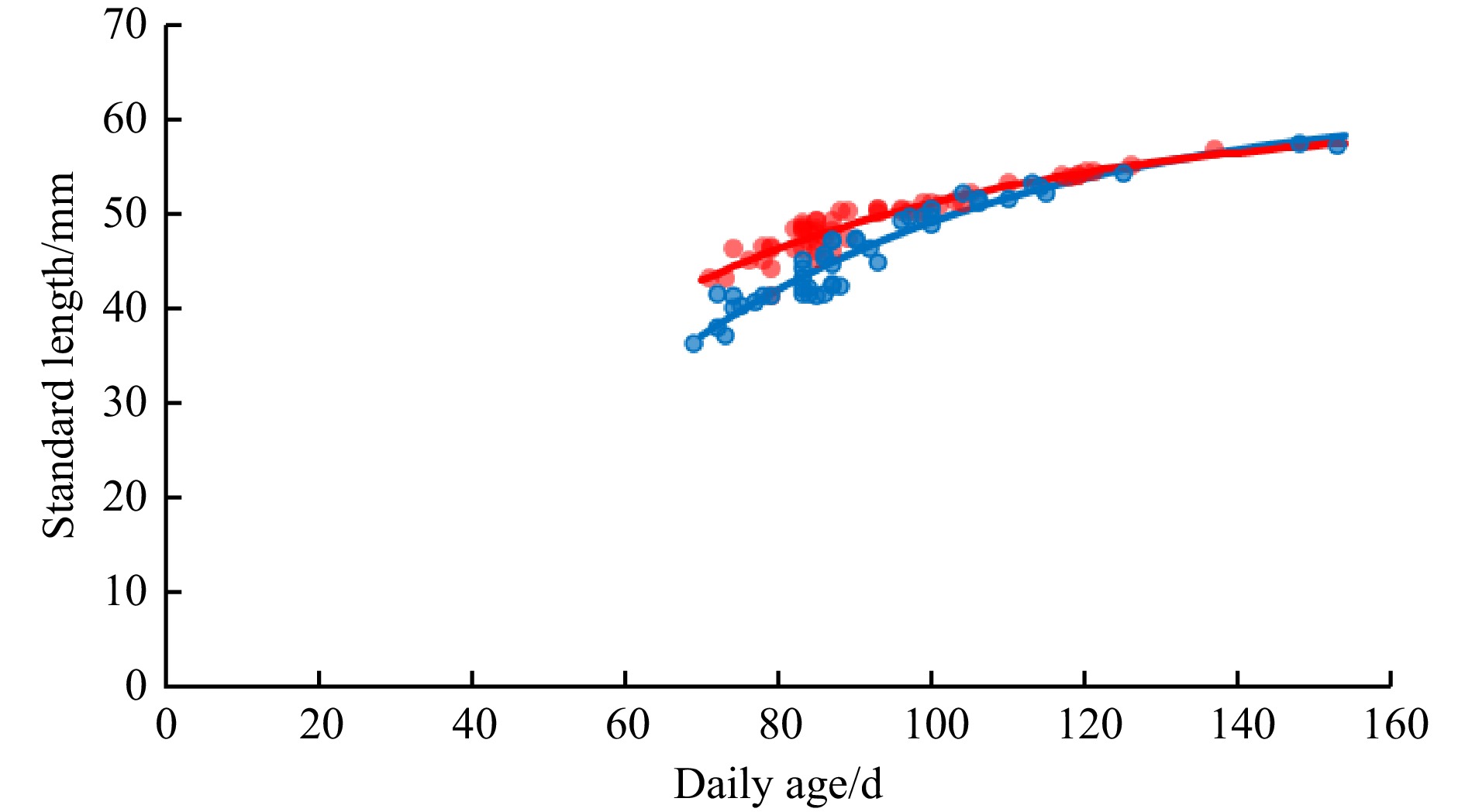

2024, 43(12): 85-101.
doi: 10.1007/s13131-024-2420-x
Abstract:
Phytoplankton blooms are complex environmental phenomena driven by multiple factors. Understanding their relationships with meteorological factors and climate oscillations is essential for advancing data-driven and hybrid statistical-dynamical models. However, these relationships have rarely been investigated across different temporal scales. This study employs wavelet transform coherence and multiple wavelet coherence to examine the multiscale and multivariate relationships between phytoplankton blooms, meteorological factors, and climate oscillations in eight large marine ecosystems of the western North Pacific. The results reveal that all phytoplankton blooms in the studied ecosystems exhibit significant annual oscillations, while seasonal climate patterns demonstrate either unimodal or bimodal distributions. A comparison of the wavelet transform coherence and multiple wavelet coherence results indicates that meteorological factors primarily drive short-period variations in phytoplankton blooms, whereas climate oscillations exert more influence on long-term changes. The explanation of phytoplankton blooms increases as the driver factors increase, but there are also some decreasing due to the collinearity between different factors. The sea-air temperature difference emerges as the most significant driving factor, with its mechanisms varying across marine ecosystems: one type influences mixed-layer depth, while the other arises from interspecific differences in temperature sensitivity. Furthermore, the results underscore the importance of integrating non-dominant large-scale circulation indices with predominant meteorological factors for a more comprehensive understanding.
Phytoplankton blooms are complex environmental phenomena driven by multiple factors. Understanding their relationships with meteorological factors and climate oscillations is essential for advancing data-driven and hybrid statistical-dynamical models. However, these relationships have rarely been investigated across different temporal scales. This study employs wavelet transform coherence and multiple wavelet coherence to examine the multiscale and multivariate relationships between phytoplankton blooms, meteorological factors, and climate oscillations in eight large marine ecosystems of the western North Pacific. The results reveal that all phytoplankton blooms in the studied ecosystems exhibit significant annual oscillations, while seasonal climate patterns demonstrate either unimodal or bimodal distributions. A comparison of the wavelet transform coherence and multiple wavelet coherence results indicates that meteorological factors primarily drive short-period variations in phytoplankton blooms, whereas climate oscillations exert more influence on long-term changes. The explanation of phytoplankton blooms increases as the driver factors increase, but there are also some decreasing due to the collinearity between different factors. The sea-air temperature difference emerges as the most significant driving factor, with its mechanisms varying across marine ecosystems: one type influences mixed-layer depth, while the other arises from interspecific differences in temperature sensitivity. Furthermore, the results underscore the importance of integrating non-dominant large-scale circulation indices with predominant meteorological factors for a more comprehensive understanding.


2024, 43(12): 102-112.
doi: 10.1007/s13131-024-2451-3
Abstract:
By establishing a distribution and environmental factor database of 21 typical harmful dinoflagellates in global waters, the MaxEnt model was used to predict shifts in the habitat of harmful dinoflagellates in Chinese waters under global climate change. The results revealed that offshore distance was the most important predictive factor and that surface seawater temperature (SST), primary productivity, and nitrate concentration were the key ecological factors influencing the distribution of harmful dinoflagellates. Under the low greenhouse gas emission scenario defined by the Intergovernmental Panel on Climate Change (IPCC), by approximately 2050, 17 of the 21 harmful dinoflagellate species in high-suitability areas (HSA) will migrate northward, six species will migrate eastward, and six species will expand their HSA. By 2100, approximately 18 of the 21 harmful dinoflagellate species in HSA will have migrated northward, seven species will have migrated eastward, and four species will have expanded their HSA. Notably, the HSA content of highly toxic Alexandrium minutum is expected to increase by 13.4% and 9.4% by 2050 and 2100, respectively. Under the high greenhouse gas emissions, there will be 17 species migrating northward, 6 species migrating eastward, and 4 species increasing in their size in HSA by 2050; moreover, there will be 16 species migrating northward, 2 migrating eastward, and 4 species according to their size of HSA by 2100. Specifically, the HSA of A. minutum is predicted to increase by 7.0% and 25.9% by 2050 and 2100, respectively. Notably, A. ostenfeldii, which is currently seldom present in the China seas, is predicted to exhibit an HSA in most coastal areas of the Yellow Sea, the Bohai Sea, the Hangzhou Bay, the Zhejiang Coast, and the Beibu Gulf of the South China Sea. Conversely, the HSA of Noctiluca scintillans, a typical red-tide species, will be reduced by 7%–90%. The northward migration of Karenia mikimotoi exceeded 100 km and 300 km under low and high greenhouse gas emission scenarios, respectively. These changes underscore the significant impact of climate change on the distribution and habitat suitability of harmful dinoflagellates, thus indicating a potential shift in their ecological dynamics and consequent effects on marine ecosystems.
By establishing a distribution and environmental factor database of 21 typical harmful dinoflagellates in global waters, the MaxEnt model was used to predict shifts in the habitat of harmful dinoflagellates in Chinese waters under global climate change. The results revealed that offshore distance was the most important predictive factor and that surface seawater temperature (SST), primary productivity, and nitrate concentration were the key ecological factors influencing the distribution of harmful dinoflagellates. Under the low greenhouse gas emission scenario defined by the Intergovernmental Panel on Climate Change (IPCC), by approximately 2050, 17 of the 21 harmful dinoflagellate species in high-suitability areas (HSA) will migrate northward, six species will migrate eastward, and six species will expand their HSA. By 2100, approximately 18 of the 21 harmful dinoflagellate species in HSA will have migrated northward, seven species will have migrated eastward, and four species will have expanded their HSA. Notably, the HSA content of highly toxic Alexandrium minutum is expected to increase by 13.4% and 9.4% by 2050 and 2100, respectively. Under the high greenhouse gas emissions, there will be 17 species migrating northward, 6 species migrating eastward, and 4 species increasing in their size in HSA by 2050; moreover, there will be 16 species migrating northward, 2 migrating eastward, and 4 species according to their size of HSA by 2100. Specifically, the HSA of A. minutum is predicted to increase by 7.0% and 25.9% by 2050 and 2100, respectively. Notably, A. ostenfeldii, which is currently seldom present in the China seas, is predicted to exhibit an HSA in most coastal areas of the Yellow Sea, the Bohai Sea, the Hangzhou Bay, the Zhejiang Coast, and the Beibu Gulf of the South China Sea. Conversely, the HSA of Noctiluca scintillans, a typical red-tide species, will be reduced by 7%–90%. The northward migration of Karenia mikimotoi exceeded 100 km and 300 km under low and high greenhouse gas emission scenarios, respectively. These changes underscore the significant impact of climate change on the distribution and habitat suitability of harmful dinoflagellates, thus indicating a potential shift in their ecological dynamics and consequent effects on marine ecosystems.
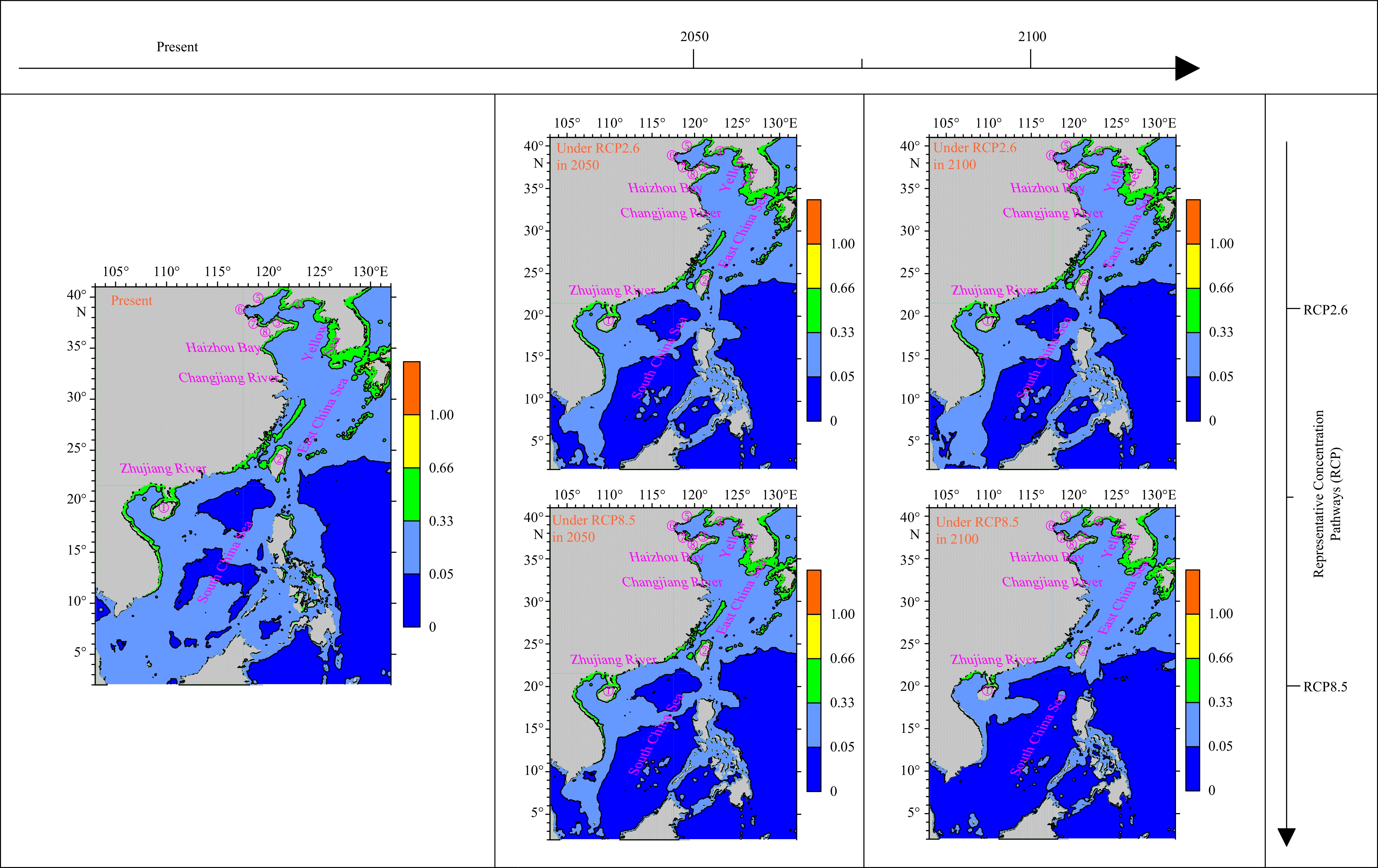
2024, 43(12): 113-122.
doi: 10.1007/s13131-024-2387-7
Abstract:
As our understanding of ecology deepens and modeling techniques advance, species distribution models have grown increasingly sophisticated, enhancing both their fitting and predictive capabilities. However, the dependability of predictive accuracy remains a critical issue, as the precision of these predictions largely hinges on the quality of the base data. We developed models using both field survey and remote sensing data from 2016 to 2020 to evaluate the impact of different data sources on the accuracy of predictions for Scomber japonicus distributions. Our research findings indicate that the variability of water temperature and salinity data from field suvery is significantly greater than that from remote sensing data. Within the same season, we found that the relationship between the abundance of S. japonicus and environmental factors varied significantly depending on the data source. Models using field survey data were able to more accurately reflect the complex relationships between resource distribution and environmental factors. Additionally, in terms of model predictive performance, models based on field survey data demonstrated greater accuracy in predicting the abundance of S. japonicus compared to those based on remote sensing data, allowing for more accurate mastery of their spatial distribution characteristics. This study highlights the significant impact of data sources on the accuracy of species distribution models and offers valuable insights for fisheries resources management.
As our understanding of ecology deepens and modeling techniques advance, species distribution models have grown increasingly sophisticated, enhancing both their fitting and predictive capabilities. However, the dependability of predictive accuracy remains a critical issue, as the precision of these predictions largely hinges on the quality of the base data. We developed models using both field survey and remote sensing data from 2016 to 2020 to evaluate the impact of different data sources on the accuracy of predictions for Scomber japonicus distributions. Our research findings indicate that the variability of water temperature and salinity data from field suvery is significantly greater than that from remote sensing data. Within the same season, we found that the relationship between the abundance of S. japonicus and environmental factors varied significantly depending on the data source. Models using field survey data were able to more accurately reflect the complex relationships between resource distribution and environmental factors. Additionally, in terms of model predictive performance, models based on field survey data demonstrated greater accuracy in predicting the abundance of S. japonicus compared to those based on remote sensing data, allowing for more accurate mastery of their spatial distribution characteristics. This study highlights the significant impact of data sources on the accuracy of species distribution models and offers valuable insights for fisheries resources management.
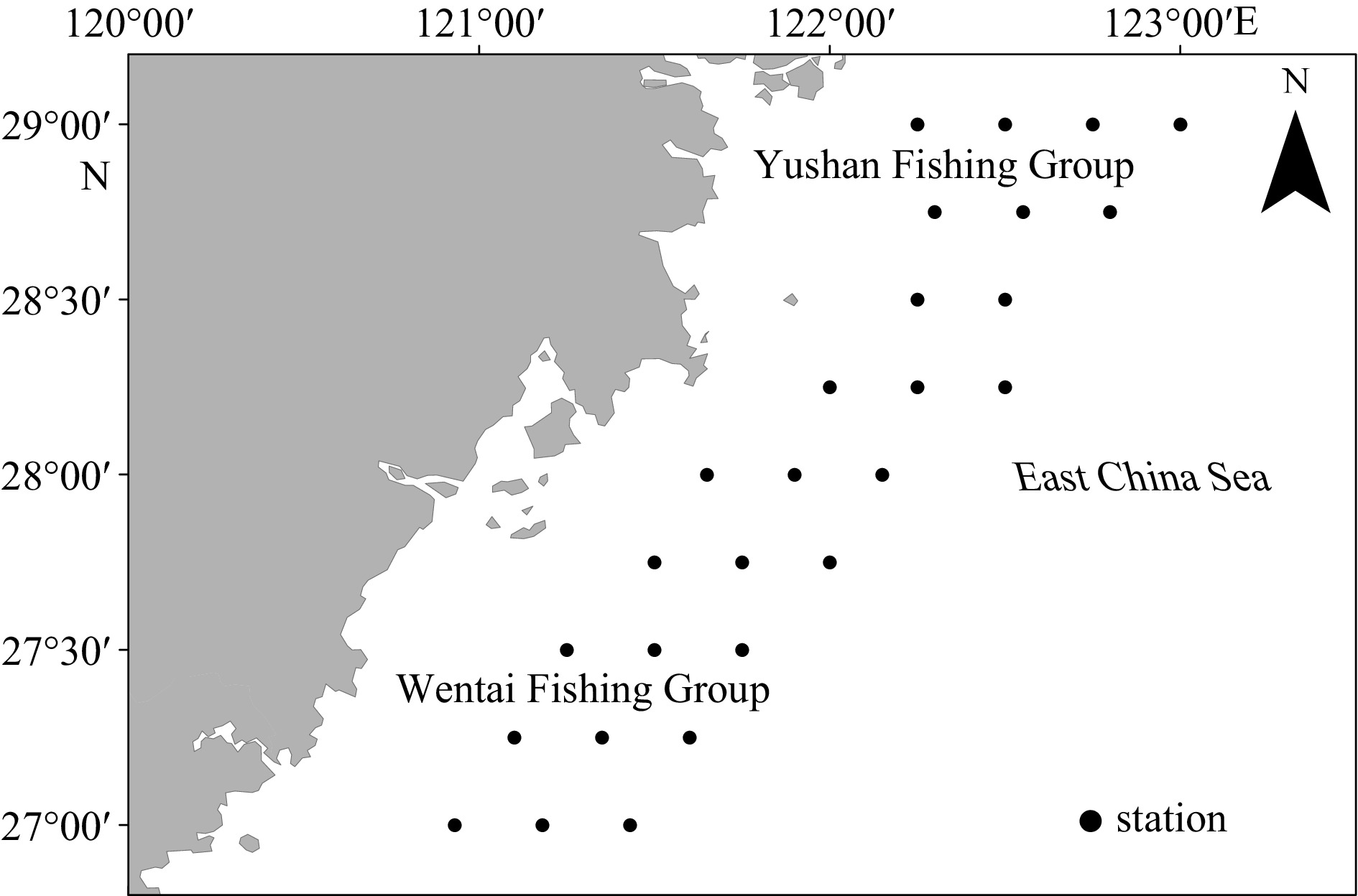


2024, 43(12): 123-140.
doi: 10.1007/s13131-024-2386-8
Abstract:
The proposed study focuses on the reported oil spill detection and assessments of oil impacts on marine ecosystems. Five selected oil spills, including those in East China Sea, Balikpapan Bay, Red Sea, Mauritius coast, and Colombo coast were detected using the Sentinel-1 satellite dataset. Sentinel-2/Landsat 8, and Sentinel-5 Precursor (S-5P) satellite datasets were utilized to observe the impacts of oil spills on vegetation cover and air quality respectively. Synthetic aperture radar-based oil spill detection techniques are effective in monitoring oil pollution. Impacts of oil spills on vegetation are monitored via different vegetation indices. The East China Sea spill moved around 190 km from the source point. The area of vegetation cover impacted by the Balikpapan Bay oil spill was 118 km2. Near real-time data of different toxic gases from S-5P were analyzed for Sri Lanka and the Red Sea using the Google Earth Engine. It is concluded that wind speed was between the range of 3 m/s to 9 m/s that is favorable for the oil spill detection, and it is also observed that wind direction had impacts on oil spill movement as well. Vegetation Indices provide highly reliable results for the four events but the Red Sea oil spill findings were not satisfactory due to low vegetation cover in this area.
The proposed study focuses on the reported oil spill detection and assessments of oil impacts on marine ecosystems. Five selected oil spills, including those in East China Sea, Balikpapan Bay, Red Sea, Mauritius coast, and Colombo coast were detected using the Sentinel-1 satellite dataset. Sentinel-2/Landsat 8, and Sentinel-5 Precursor (S-5P) satellite datasets were utilized to observe the impacts of oil spills on vegetation cover and air quality respectively. Synthetic aperture radar-based oil spill detection techniques are effective in monitoring oil pollution. Impacts of oil spills on vegetation are monitored via different vegetation indices. The East China Sea spill moved around 190 km from the source point. The area of vegetation cover impacted by the Balikpapan Bay oil spill was 118 km2. Near real-time data of different toxic gases from S-5P were analyzed for Sri Lanka and the Red Sea using the Google Earth Engine. It is concluded that wind speed was between the range of 3 m/s to 9 m/s that is favorable for the oil spill detection, and it is also observed that wind direction had impacts on oil spill movement as well. Vegetation Indices provide highly reliable results for the four events but the Red Sea oil spill findings were not satisfactory due to low vegetation cover in this area.

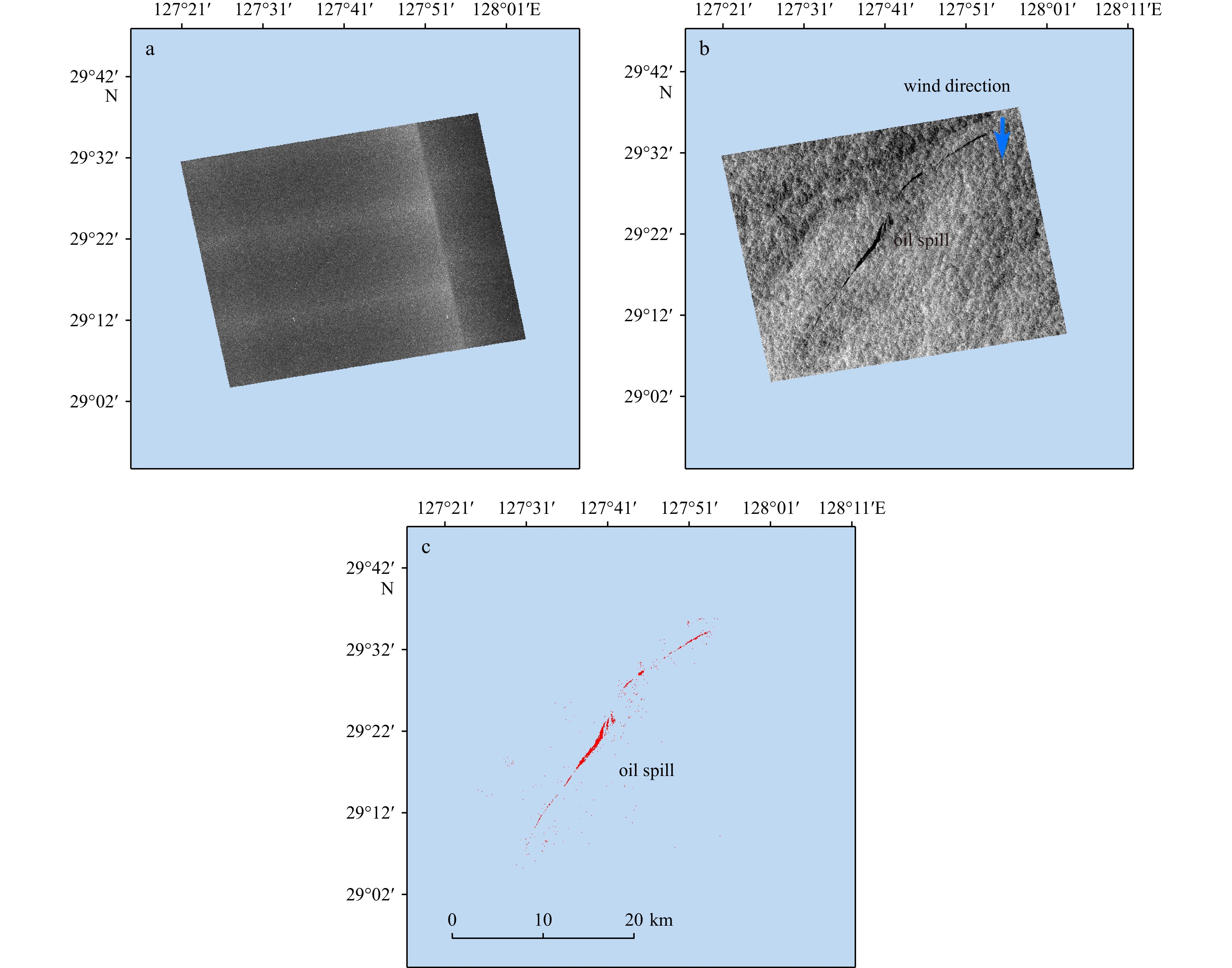

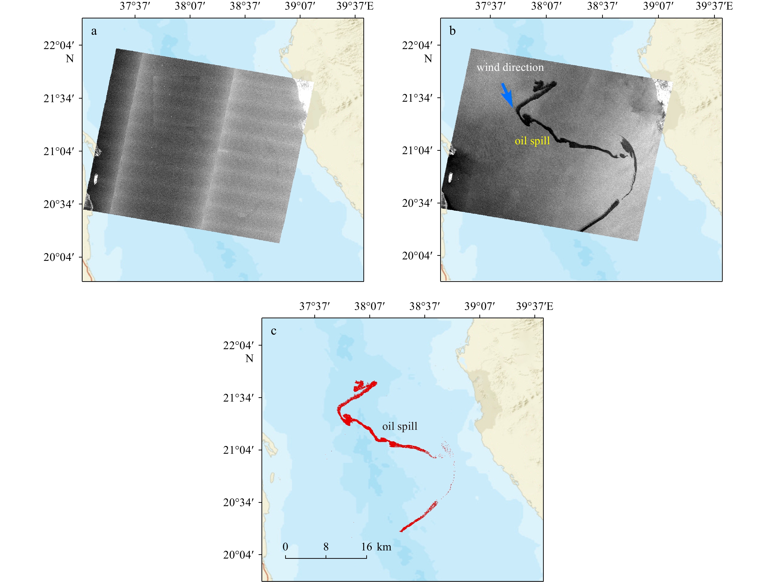
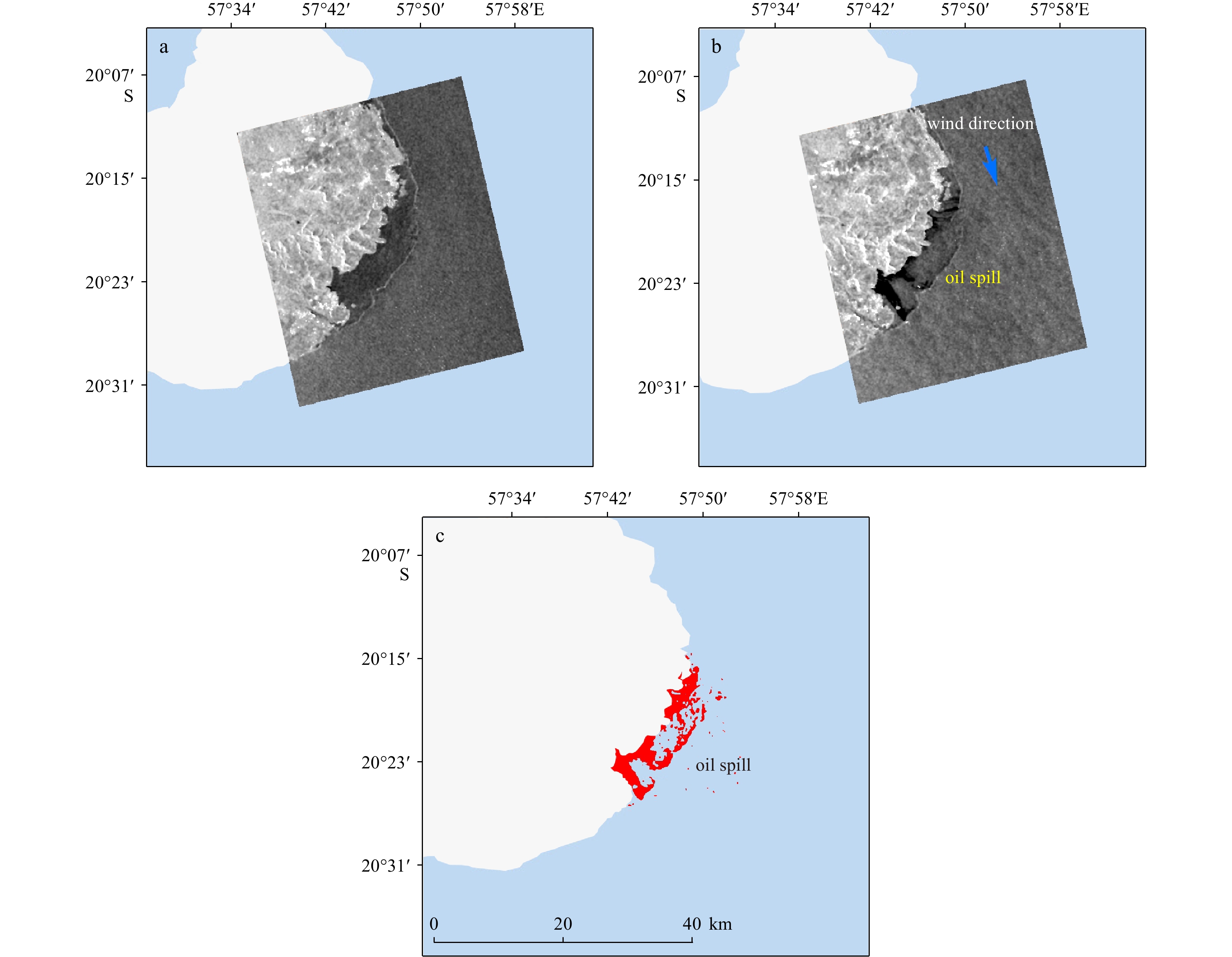


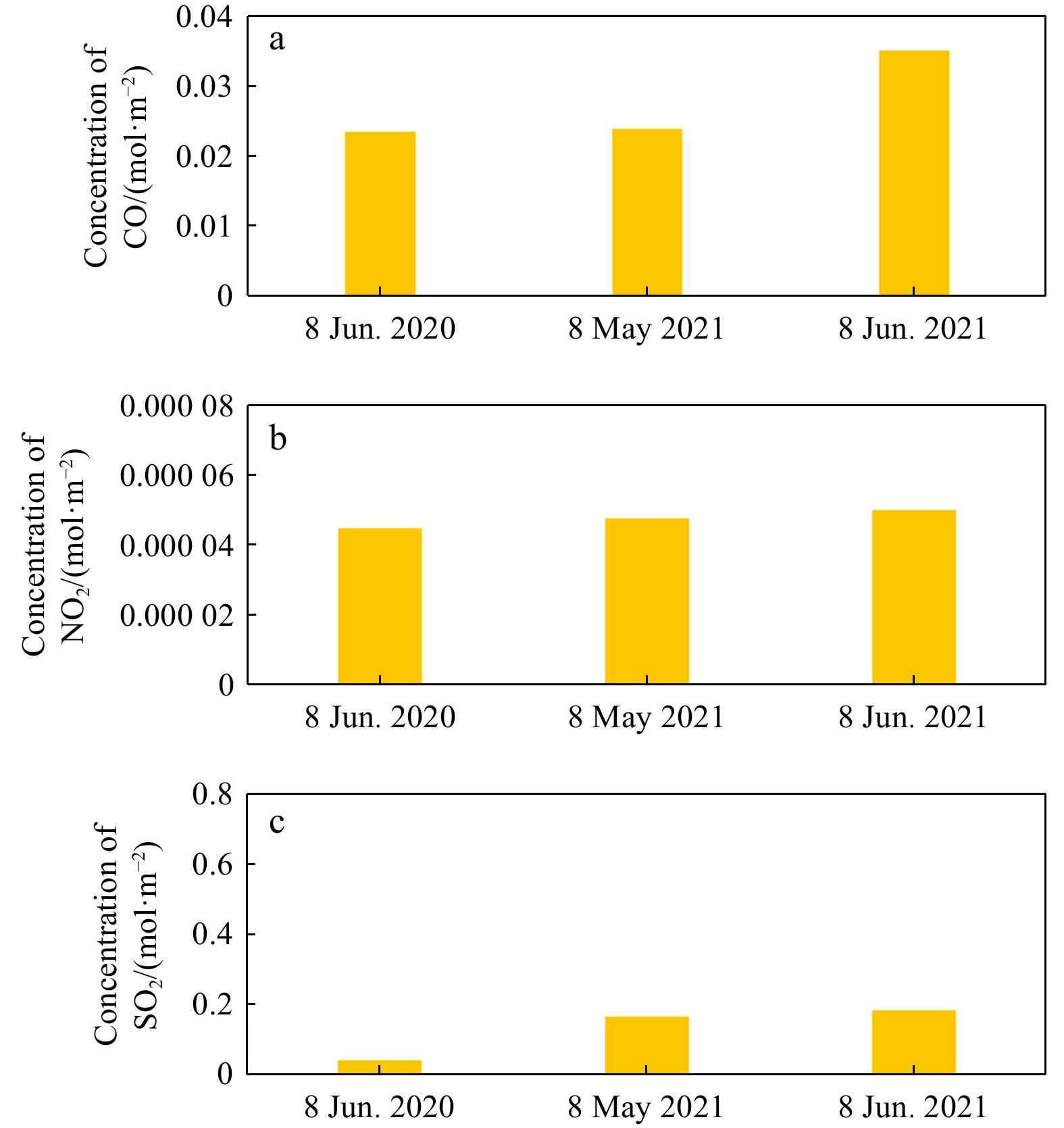
Latest Issues
Impact Factor: 0
ISSN 0253-505X (Print)
0253-505X (Online)
CN 11-2056/P
ISSN 0253-505X (Print)
0253-505X (Online)
CN 11-2056/P
ISSN 0253-505X
CN 11-2056/P
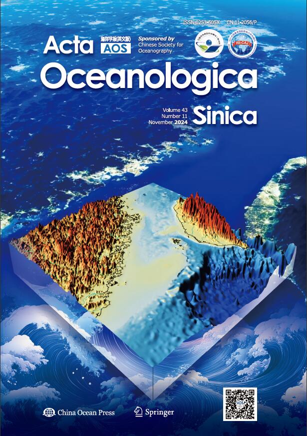
Impact Factor: 0
ISSN 0253-505X (Print)
0253-505X (Online)
CN 11-2056/P
ISSN 0253-505X (Print)
0253-505X (Online)
CN 11-2056/P
ISSN 0253-505X
CN 11-2056/P

Impact Factor: 0
ISSN 0253-505X (Print)
0253-505X (Online)
CN 11-2056/P
ISSN 0253-505X (Print)
0253-505X (Online)
CN 11-2056/P
ISSN 0253-505X
CN 11-2056/P
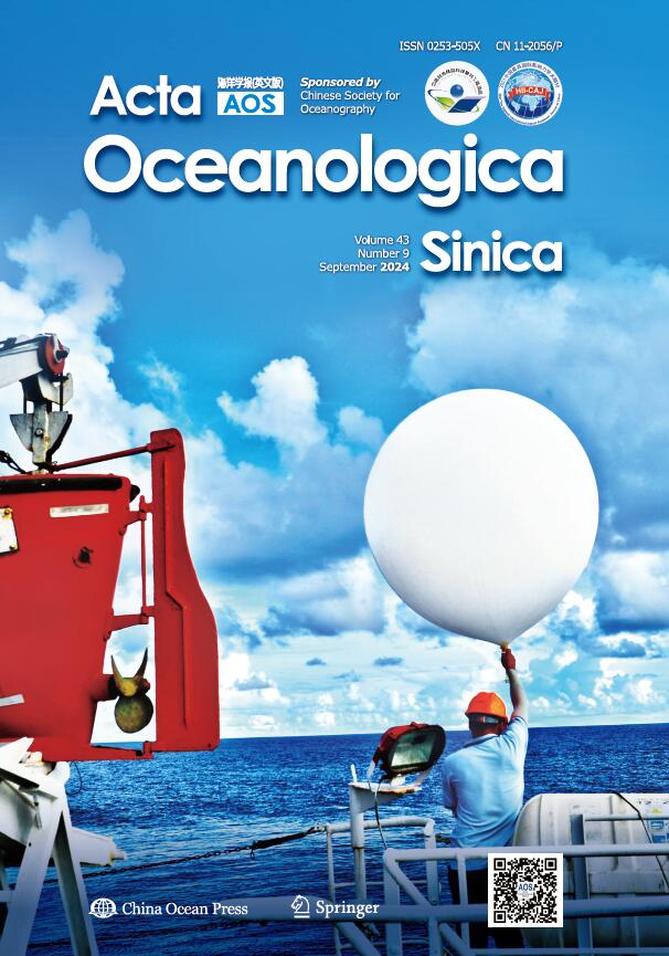
Impact Factor: 0
ISSN 0253-505X (Print)
0253-505X (Online)
CN 11-2056/P
ISSN 0253-505X (Print)
0253-505X (Online)
CN 11-2056/P
ISSN 0253-505X
CN 11-2056/P
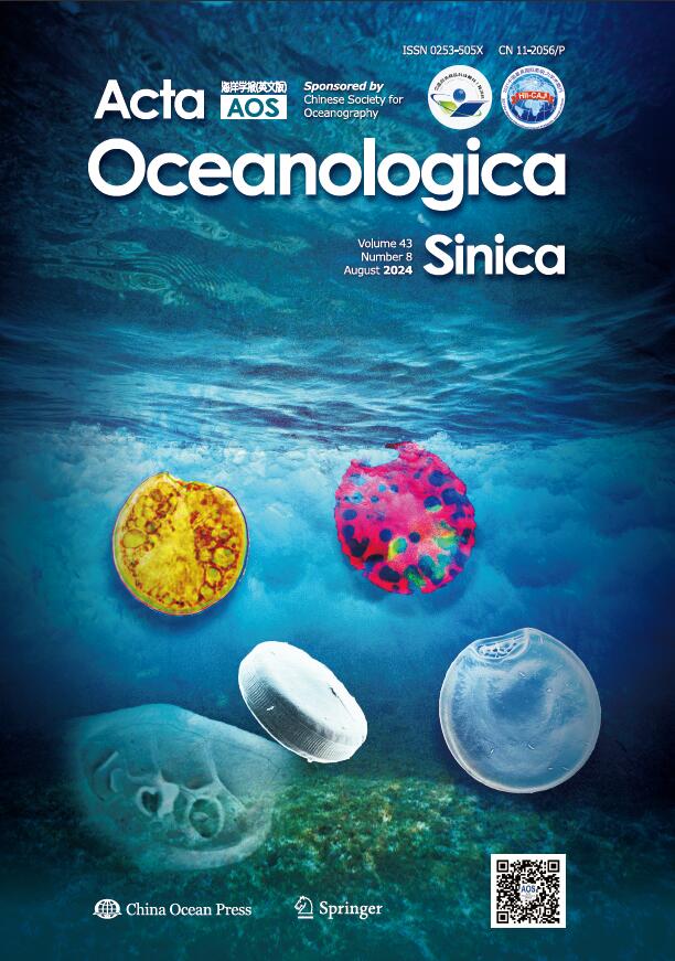
Impact Factor: 0
ISSN 0253-505X (Print)
0253-505X (Online)
CN 11-2056/P
ISSN 0253-505X (Print)
0253-505X (Online)
CN 11-2056/P
ISSN 0253-505X
CN 11-2056/P
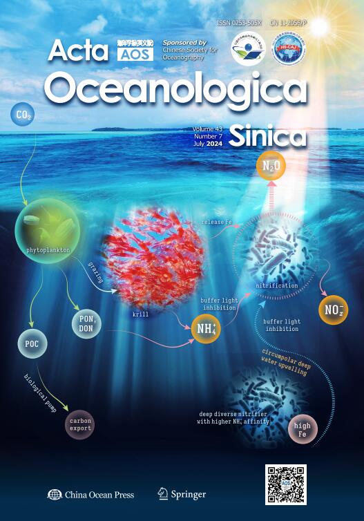
Impact Factor: 0
ISSN 0253-505X (Print)
0253-505X (Online)
CN 11-2056/P
ISSN 0253-505X (Print)
0253-505X (Online)
CN 11-2056/P
ISSN 0253-505X
CN 11-2056/P


