Vertical structure of tidal currents in the Xuliujing Section of Changjiang River Estuary
-
Abstract: Three long-term fixed acoustic Doppler current profilers were first used for investigating the vertical structure of tidal currents in Xuliujing Section of Changjiang River Estuary. Moreover, three different periods (spring, summer and fall) were also considered for investigating seasonal variations. The semi-diurnal tides were the most energetic, with along-channel speed of up to 80 cm/s for M2 constituent, which dominates at all stations with percent energy up to 65%–75% during seasons. The shape of tidal ellipses of the most energetic semi-diurnal constituent M2 showed obvious polarization of the flow paralleling to the riverbank, with the minor semi-axis being generally less than 20% of the major one. The maximum velocity of mean current is appeared in top layers at all the three stations, and the velocity decreased with the depth. The seasonal variations of direction are also observed, which is probably caused by complex local topography since the erosion and deposition in riverbed. Observed vertical variation of four parameters of M2 ellipses, agreed well with the optimally fit frictional solutions in top and middle layers. However, there was an obvious difference between frictional model and observed data in the lower water column. Discrepancies are probably on account of stratification, which strengthens in summer and fall due to the freshening influence of the Changjiang River Estuary outflow.
-
Figure 2. Time series of the discharges at Datong Station (thumbnail image in Fig. 1) in 2011. Datong is the last permanent hydrometric station with long discharge records on the main Changjiang River, and the discharge is difficult to observe owing to the tidal influence. So the discharge in Datong is commonly regarded as the net discharge into the East China Sea.
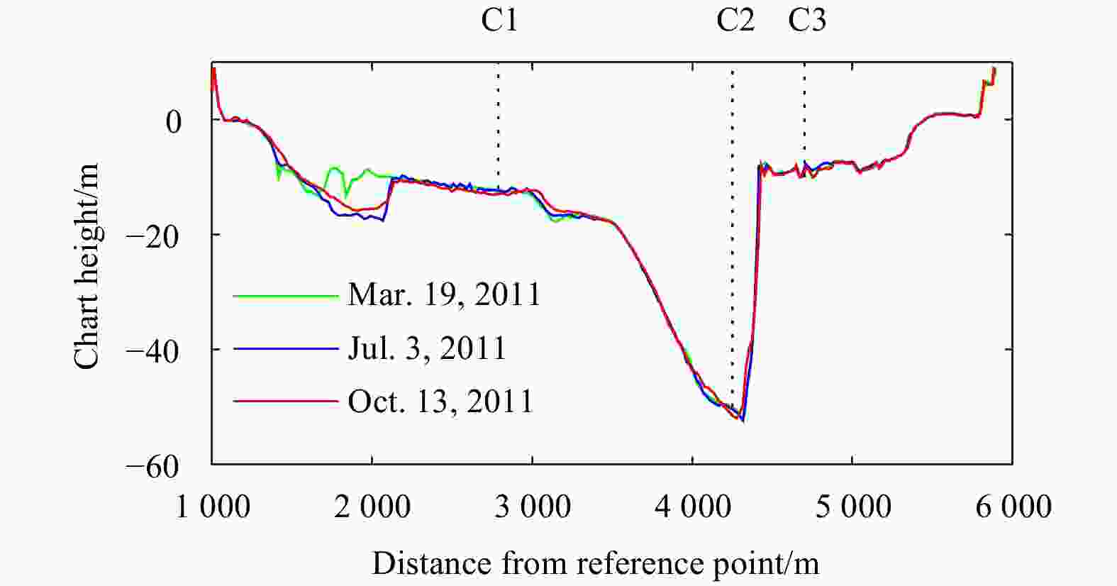
Figure 3. Shapes of Xuliujing Section on three different dates of 2011. A boat-mounted single-beam echo sounder transducer (sonar) was used for bathymetric surveying at Xuliujing Section (Fig. 1) once a month. The echo sounder was a 208 kHz HY1600, 8 degree transducer, with a depth accuracy of 0.01 m+0.1%D (D is measured depth) and sampling rate of 5 Hz.
Figure 4. Energy partition of vertical-averaged currents at three acoustic Doppler current profiler stations. Area of pie chart (top-row) indicates total kinetic energy variance
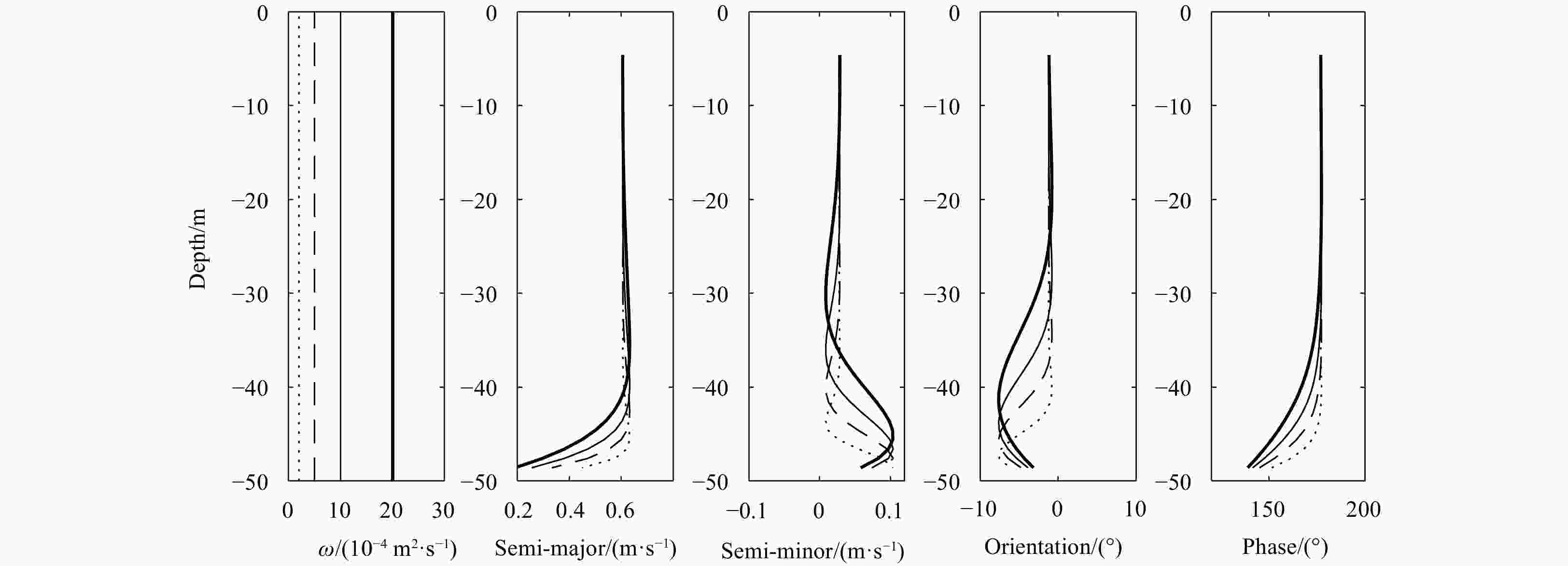
$\sigma^2_{{\rm{KE}}_{{\rm{dat}}}}$ , and the sector is the Kinetic energy variance ratio VE, which represents relative contribution of the tidal component to the total flow in each season. The largest pie appears at Station C2 in summer and it represents 0.67 m4/s4. Histogram bars indicate percent energy En in the individual constituents.Figure 8. The vertical distribution of M2 ellipse parameters and the frictional model for three stations. Dots indicate measured data, solid lines are optimally fit model solution with a constant eddy viscosity and corresponding value of cost function (detailed in Section 4.1). Horizontal lines denote the tidal-averaged water depth.
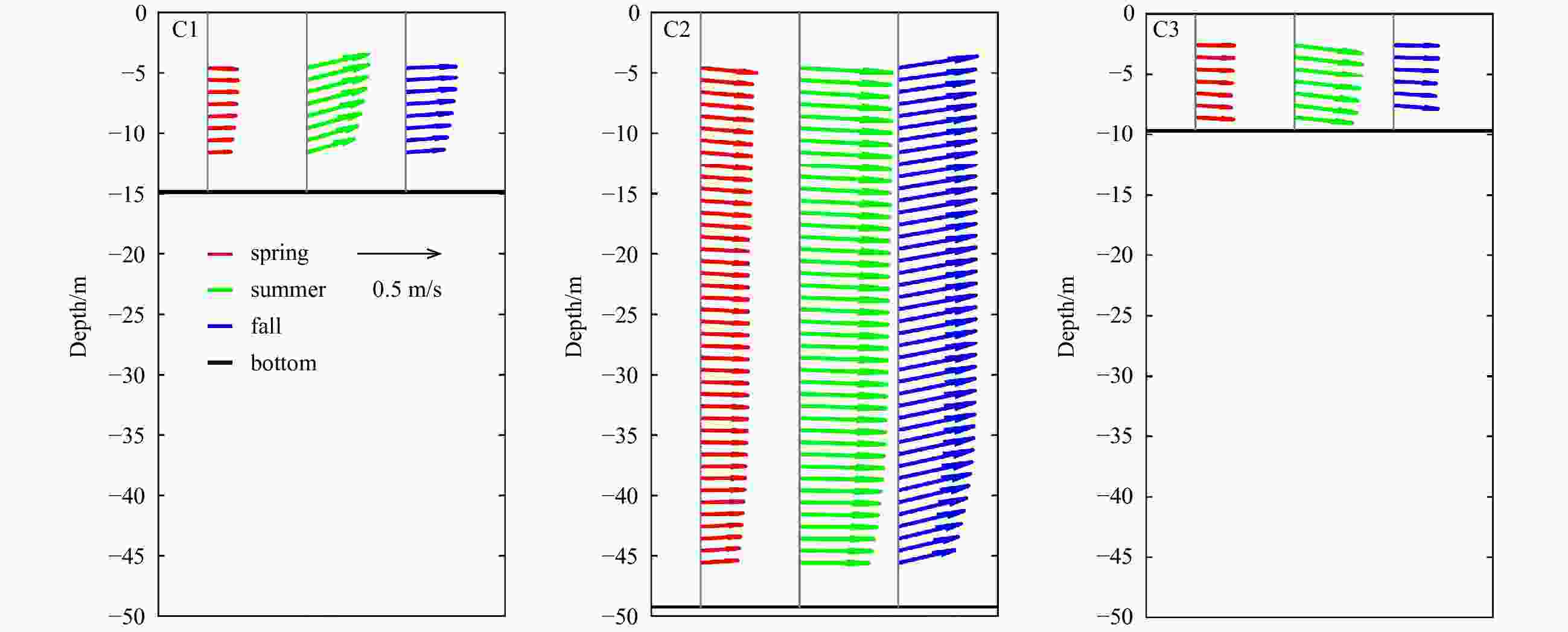
Table 1. Basic parameters of the three acoustic Doppler current profiler stations located in Xuliujing Section
Station Depth/
mTop unmeasured
length/mBottom unmeasured length/m Number of
valid binsC1 14.9 ~2 ~3 9 C2 51.5 ~4 ~4 45 C3 9.7 ~2 ~2 6 -
Beardsley R C, Limeburner R, Yu H, et al. 1985. Discharge of the Changjiang (Yangtze River) into the East China Sea. Continental Shelf Research, 4(1−2): 57–76. doi: 10.1016/0278-4343(85)90022-6 Bi Congcong, Bao Xianwen, Ding Yang, et al. 2019. Observed characteristics of tidal currents and mean flow in the northern Yellow Sea. Journal of Oceanology and Limnology, 37(2): 461–473. doi: 10.1007/s00343-019-8026-z Bolaños R, Brown J M, Amoudry L O, et al. 2013. Tidal, riverine, and wind influences on the circulation of a macrotidal estuary. Journal of Physical Oceanography, 43(1): 29–50. doi: 10.1175/JPO-D-11-0156.1 Chen Zhongyuan, Li Jiufa, Shen Huanting, et al. 2001. Yangtze River of China: historical analysis of discharge variability and sediment flux. Geomorphology, 41(2−3): 77–91. doi: 10.1016/S0169-555X(01)00106-4 Codiga D L, Rear L V. 2004. Observed tidal currents outside Block Island Sound: offshore decay and effects of estuarine outflow. Journal of Geophysical Research, 109(C7): C07S05 Davies A G. 1990. A model of the vertical structure of the wave and current bottom boundary layer. In: Davies A M, ed. Modeling Marine Systems. Boca Raton: CRC Press, 263–297 DiMarco S F, Reid R O. 1998. Characterization of the principal tidal current constituents on the Texas-Louisiana shelf. Journal of Geophysical Research, 103(C2): 3093–3109. doi: 10.1029/97JC03289 Godin G. 1972. The Analysis of Tides. Toronto: University of Toronto Press Herrera J L, Varela R A, Rosón G. 2008. Spatial variability of the barotropic M2 constituent tidal current over the Rías Baixas Galician shelf (NW Spain). Journal of Marine Systems, 72(1−4): 189–199. doi: 10.1016/j.jmarsys.2007.07.006 Kundu P K, Blanton J O, Janopaul M M. 1981. Analysis of current observations on the Georgia shelf. Journal of Physical Oceanography, 11(8): 1139–1149. doi: 10.1175/1520-0485(1981)011<1139:AOCOOT>2.0.CO;2 Larsen L H, Cannon G A, Choi B H. 1985. East China Sea tide currents. Continental Shelf Research, 4(1−2): 77–103. doi: 10.1016/0278-4343(85)90023-8 Lee S, Lie H J, Cho C H, et al. 2011. Vertical structure of the M2 tidal current in the Yellow Sea. Ocean Science Journal, 46(2): 73–84. doi: 10.1007/s12601-011-0007-x Liu Dujuan. 2004. The situation and analysis of salinity intrusion in coastal areas, China. Journal of Geological Hazards and Environment Preservation, 15(1): 31–36 López M, Flores-Mateos L, Candela J. 2021. Tidal currents at the sills of the Northern Gulf of California. Continental Shelf Research, 227: 104513. doi: 10.1016/j.csr.2021.104513 Mei Xuefei, Zhang Min, Dai Zhijun, et al. 2019. Large addition of freshwater to the tidal reaches of the Yangtze (Changjiang) River. Estuaries and Coasts, 42(3): 629–640. doi: 10.1007/s12237-019-00518-0 Mohn C, Erofeeva S, Turnewitsch R, et al. 2013. Tidal and residual currents over abrupt deep-sea topography based on shipboard ADCP data and tidal model solutions for three popular bathymetry grids. Ocean Dynamics, 63(2−3): 195–208. doi: 10.1007/s10236-013-0597-1 Muste M, Kim D, González-Castro J A. 2010. Near-transducer errors in ADCP measurements: experimental findings. Journal of Hydraulic Engineering, 136(5): 275–289. doi: 10.1061/(ASCE)HY.1943-7900.0000173 Pawlowicz R, Beardsley B, Lentz S. 2002. Classical tidal harmonic analysis including error estimates in MATLAB using T_TIDE. Computers & Geosciences, 28(8): 929–937 Prandle D. 1982. The vertical structure of tidal currents and other oscillatory flows. Continental Shelf Research, 1(2): 191–207. doi: 10.1016/0278-4343(82)90004-8 Pu Xiang, Shi J Z, Hu Guodong. 2017. The effect of stratification on the vertical structure of the tidal ellipse in the Changjiang River Estuary, China. Journal of Hydro-environment Research, 15: 75–94. doi: 10.1016/j.jher.2017.03.004 Sánchez-Román A, Criado-Aldeanueva F, García-Lafuente J, et al. 2008. Vertical structure of tidal currents over Espartel and Camarinal sills, Strait of Gibraltar. Journal of Marine Systems, 74(1−2): 120–133. doi: 10.1016/j.jmarsys.2007.11.007 Siagian H, Ismanto A, Putra T W L, et al. 2021. Stratification on the vertical structure of the tidal ellipse and power density estimation in the Larantuka Strait, East Flores Based on ADCP measurement data. IOP Conference Series: Earth and Environmental Science, 750(1): 012023. doi: 10.1088/1755-1315/750/1/012023 Teague W J, Jacobs G A, Perkins H T, et al. 2002. Low-frequency current observations in the Korea/Tsushima Strait. Journal of Physical Oceanography, 32(6): 1621–1641. doi: 10.1175/1520-0485(2002)032<1621:LFCOIT>2.0.CO;2 Tsimplis M N. 2000. Vertical structure of tidal currents over the Camarinal Sill at the Strait of Gibraltar. Journal of Geophysical Research, 105(C8): 19709–19728. doi: 10.1029/2000JC900066 Ullman D S, Codiga D L. 2004. Seasonal variation of a coastal jet in the Long Island Sound outflow region based on HF radar and Doppler current observations. Journal of Geophysical Research, 109(C7): C07S06 Wang Kai, Fang Guohong, Feng Shizuo. 1999. A 3-D numerical simulation of M2 tides and tidal currents in the Bohai Sea, the Huanghai Sea and the East China Sea. Haiyang Xuebao (in Chinese), 21(4): 1–13 Wong K C, Münchow A. 1995. Buoyancy forced interaction between estuary and inner shelf: observation. Continental Shelf Research, 15(1): 59–88. doi: 10.1016/0278-4343(94)P1813-Q Wünchow A, Masse A K, Garvine R W. 1992. Astronomical and nonlinear tidal currents in a coupled estuary shelf system. Continental Shelf Research, 12(4): 471–498. doi: 10.1016/0278-4343(92)90087-Z Yang Yunping, Li Yitian, Han Jianqiao, et al. 2012. Variation of tide limit and tidal current limit in Yangtze Estuary and its impact on projects. Journal of Sediment Research, 37(6): 46–51 Zhao Jianhu, Chen Zhigao, Zhang Hongmei, et al. 2016. Multiprofile discharge estimation in the tidal reach of Yangtze Estuary. Journal of Hydraulic Engineering, 142(12): 04016056. doi: 10.1061/(ASCE)HY.1943-7900.0001201 Zhu Xueming, Bao Xianwen, Song Dehai, et al. 2012. Numerical study on the tides and tidal currents in Bohai Sea, Yellow Sea and East China Sea. Oceanologia et Limnologia Sinica, 43(6): 1103–1113 -


 下载:
下载:


