

Mounded seismic units in the modern canyon system in the Shenhu area, northern South China Sea: Sediment deformation, depositional structures or the mixed system?
-
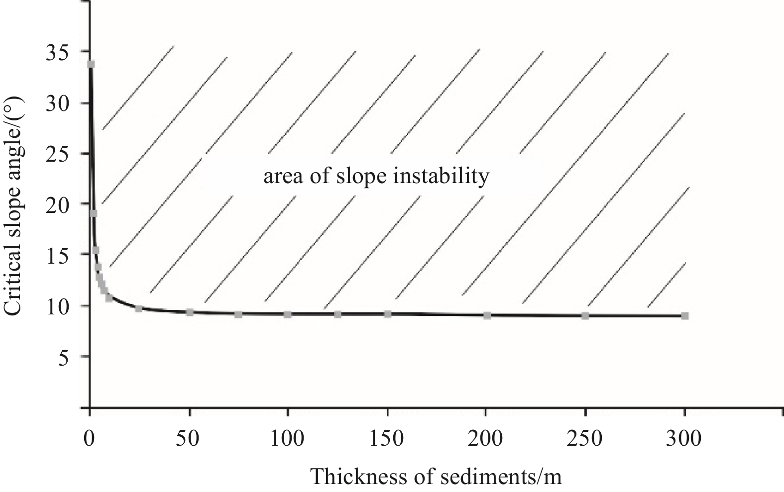
Abstract: The canyon system, including 17 small slope-confined canyons in the Shenhu area, northern South China Sea, is significantly characterized by mounded or undulating features on the canyon flanks and canyon heads. However, the mechanism underlying the formation of these features has yet to be elucidated. In previous studies, most of them were interpreted as sediment deformation on the exploration seismic profiles. In this paper, we collected high-resolution bathymetric data, chirp profiles and geotechnical test data to investigate their detailed morphology, internal structures, and origin. The bathymetric data indicated that most mounded seismic units have smooth seafloors and are separated by grooves or depressions. The distance between two adjacent mounded units is only hundreds of meters. On chirp profiles, mounded seismic units usually exhibit chaotic reflections and wavy reflections, of which the crests migrate upslope. The slope stability analysis results revealed that the critical angle of the soil layers in the study area tends to be 9°, indicating that most mounded seismic units on the canyon flanks and heads are stable at present. The terrain characteristics and seismic configurations combined with the slope stability analysis results indicated that most mounded seismic units are not sediment deformation but depositional structures or mixed systems composed of deformation and depositional structures.
-
Key words:
- northern South China Sea /
- submarine canyons /
- mounded seismic units /
- chirp profile /
- slope stability
-
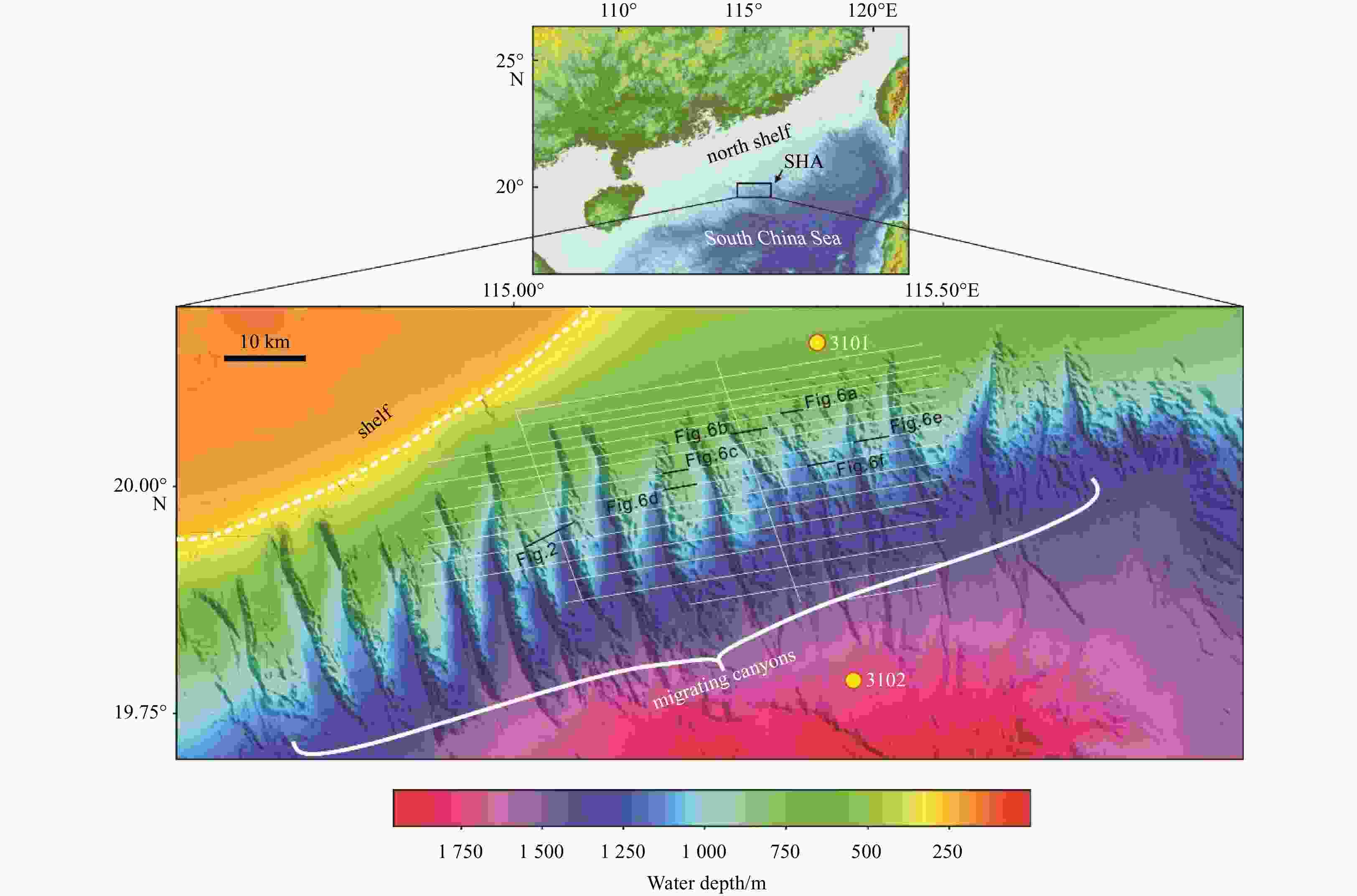
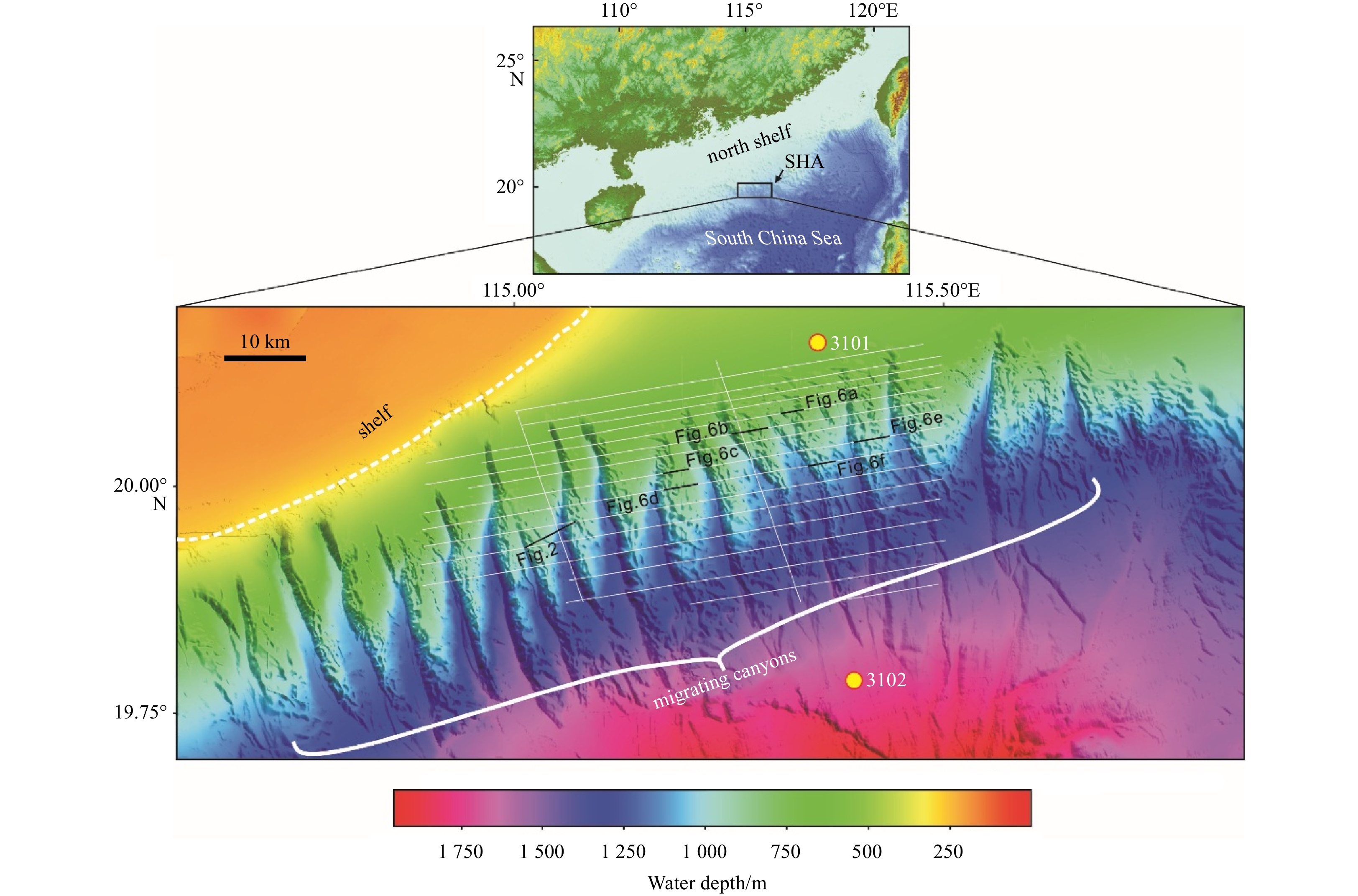
Figure 1. Bathymetric map of the study area and geophysical data tracks. The study area is shown in the inserted map in the upper. The bathymetric map is based on multibeam bathymetric data combined with water depths derived from 3D seismic data. The shelf break is near the 250 m isobath. White thin lines represent subbottom profiles, and yellow dots denote 100-m boreholes. SHA: Shenhu area.
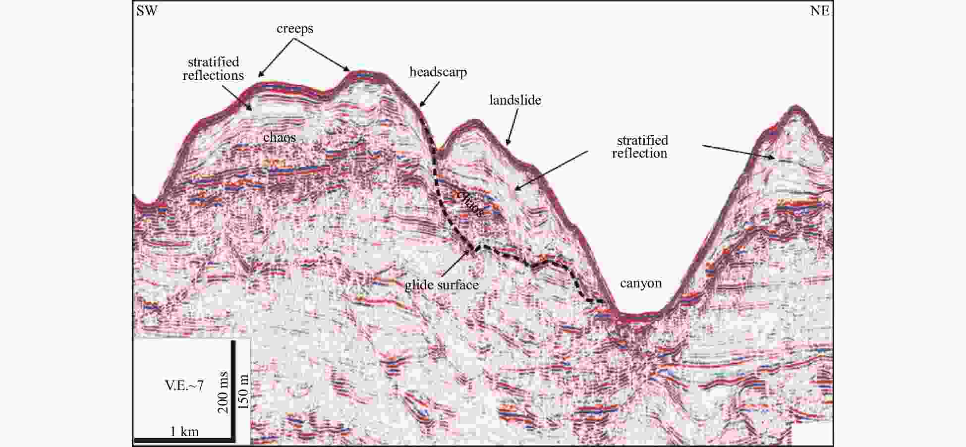
Figure 2. Interpretation of landslides on an exploration seismic profile in the canyon flanks (after He et al., 2014). See Fig. 1 for the location. The seismic facies inside the landslides include chaotic and stratified reflections with variable amplitudes. V.E.~7 indicates that the vertical scale is exaggerated approximately 7 times.
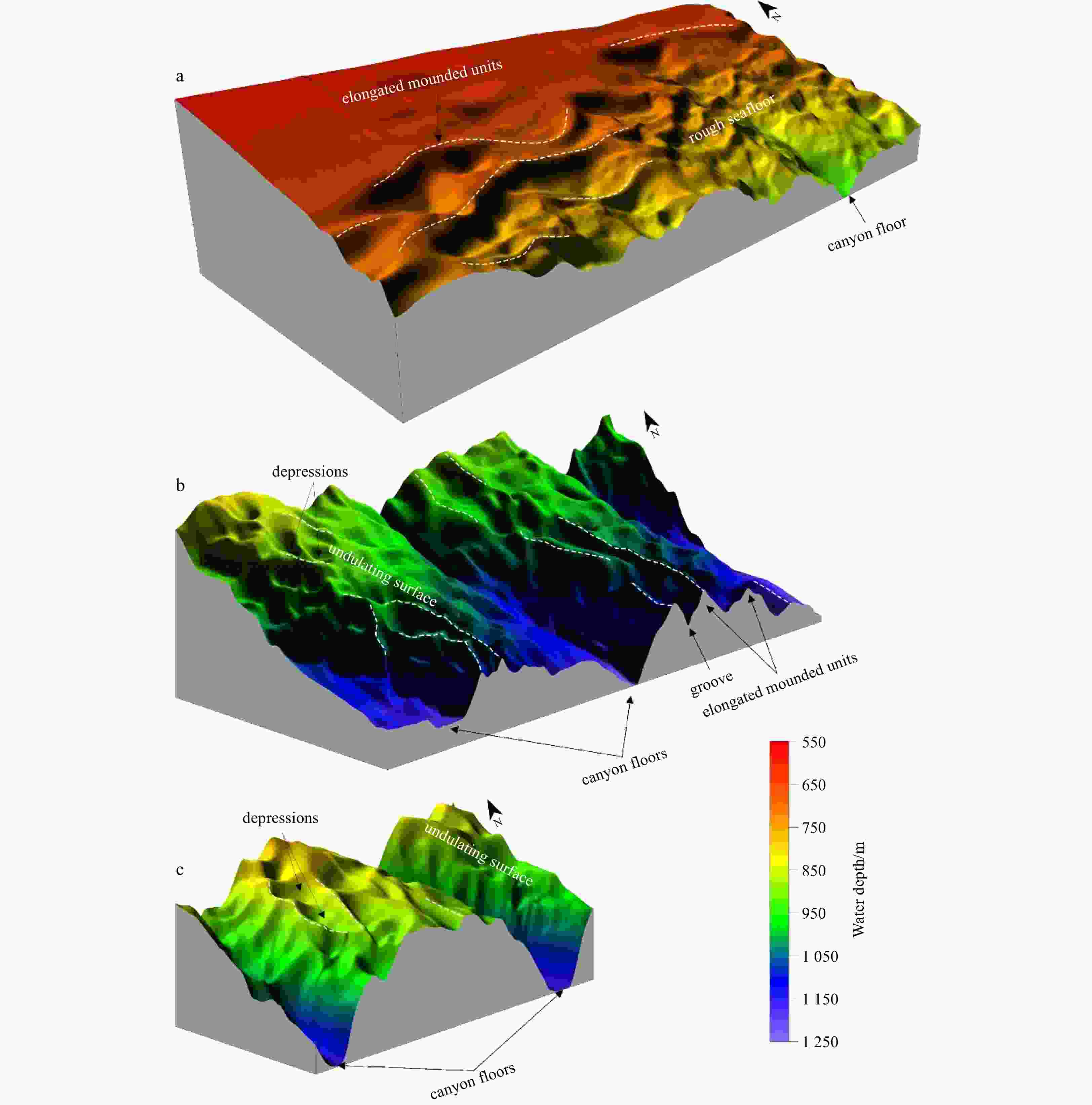
Figure 4. 3D surface maps of canyon head (a) and canyon flanks (b, c). See Fig. 3 for their locations. White dotted lines represent splines of elongated mounded units.
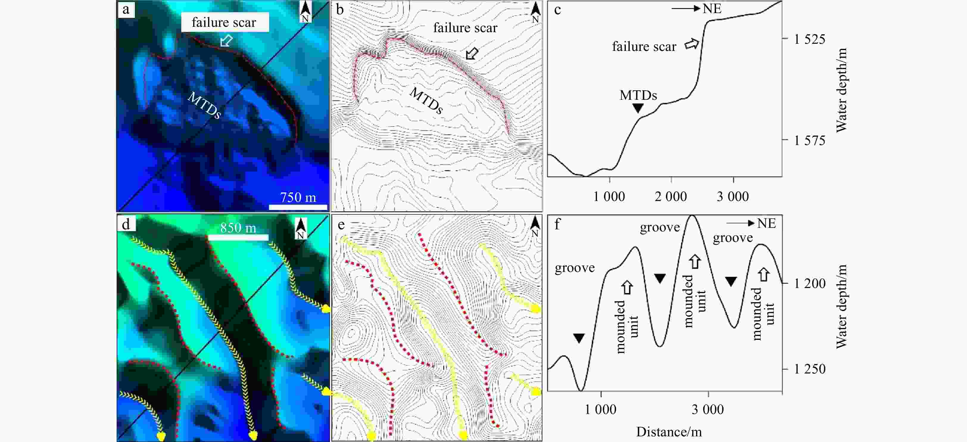
Figure 5. Bathymetric map showing the morphology of a typical landslide (a–c) and the physiographic characterization of mounded seismic units on the canyon flank (d–f). See Fig. 3 for their locations. The red zigzag lines denote the failure scar of a slide, and the red dotted lines represent spines of mounded units. The yellow arrow lines represent grooves.
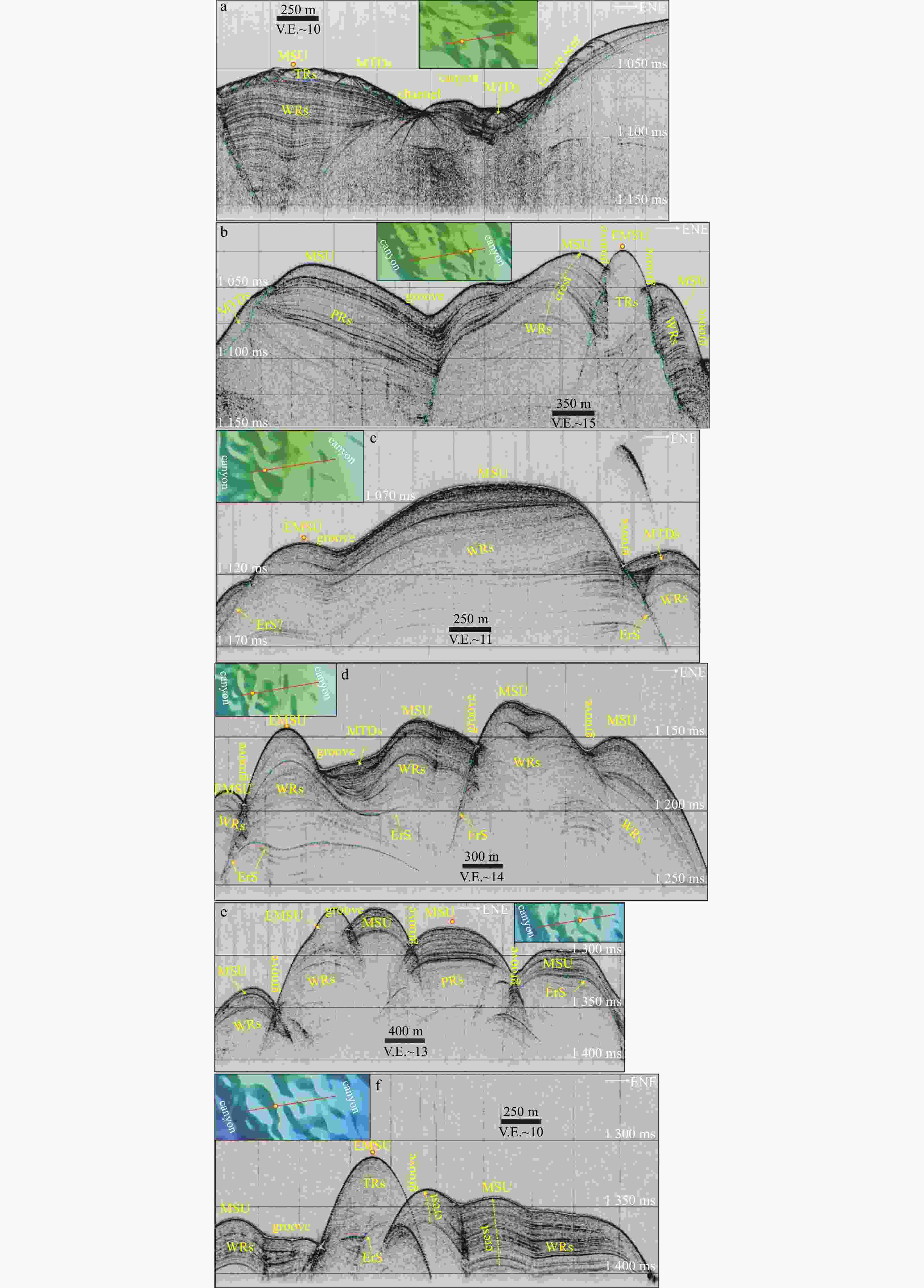
Figure 6. Chirp profiles show seismic architectures of elongated or mounded units on the canyon flanks. See Fig. 1 for their tracks. WRs: wavy reflections; TRs: translucent reflections; PRs: parallel reflections; ErS: electronic surface; MSU: mounded seismic units; EMSU: elongated mounded seismic units. Blue dotted lines denote erosional surfaces. V.E.~10 indicates that the vertical scale is exaggerated approximately 10 times.
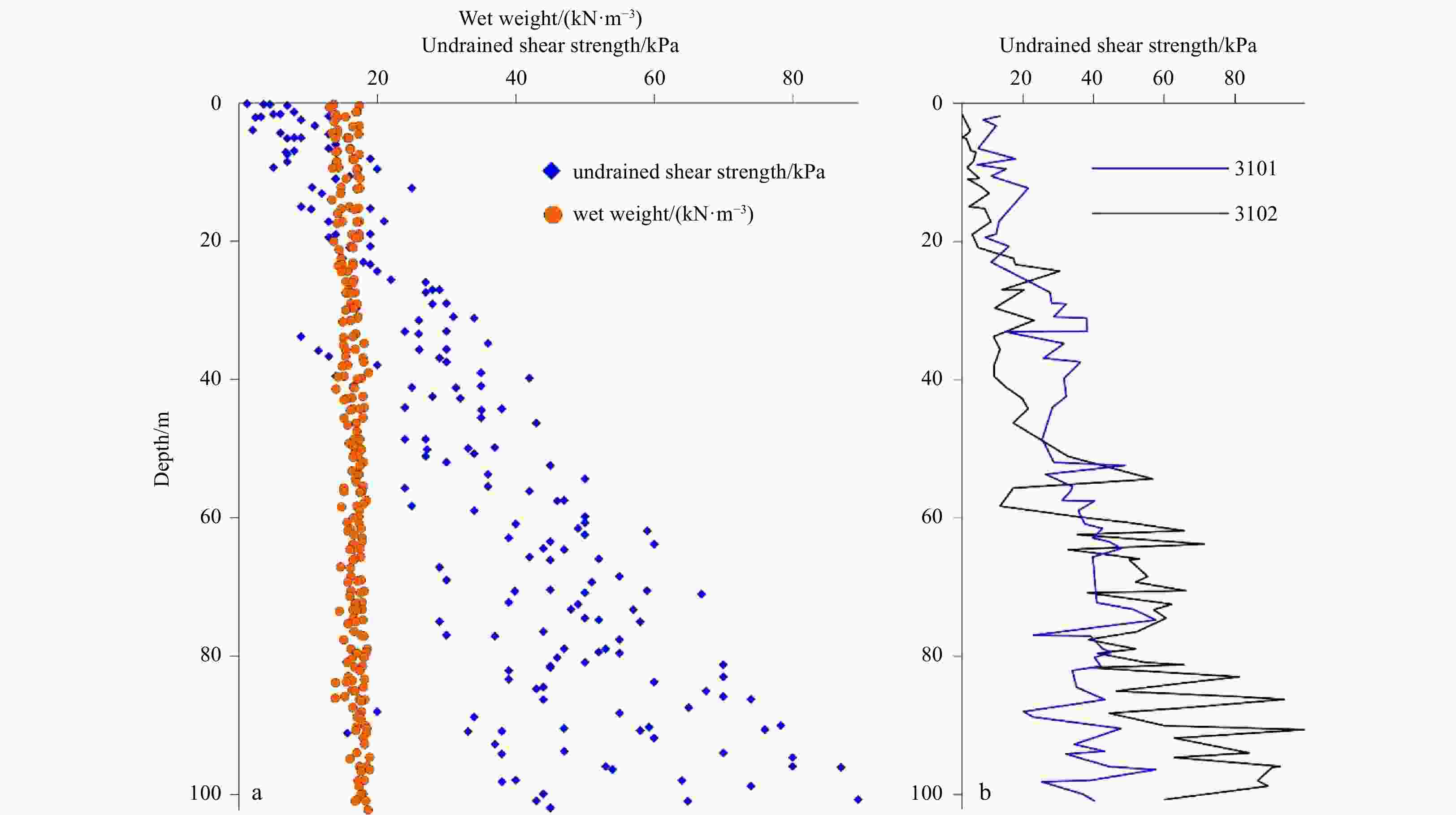
Figure 7. Variation in wet bulk density and undrained shear strength vs. depth in two 100-m boreholes (a) and undrained shear strength profiles at Boreholes 3101 and 3102 (b). The locations of the boreholes are shown in Fig. 1.
-
[1] Alford M H, Peacock T, MacKinnon J A, et al. 2015. The formation and fate of internal waves in the South China Sea. Nature, 521(7550): 65–69. doi: 10.1038/nature14399 [2] Baeten N J, Laberg J S, Forwick M, et al. 2013. Morphology and origin of smaller-scale mass movements on the continental slope off northern Norway. Geomorphology, 187: 122–134. doi: 10.1016/j.geomorph.2013.01.008 [3] Berndt C, Costa S, Canals M, et al. 2012. Repeated slope failure linked to fluid migration: the Ana submarine landslide complex, Eivissa Channel, western Mediterranean Sea. Earth and Planetary Science Letters, 319–320: 65–74 [4] Bøe R, Hovland M, Instanes A, et al. 2000. Submarine slide scars and mass movements in Karmsundet and Skudenesfjorden, southwestern Norway: morphology and evolution. Marine Geology, 167(1−2): 147–165. doi: 10.1016/S0025-3227(00)00017-7 [5] Bull S, Cartwright J, Huuse M. 2009. A review of kinematic indicators from mass-transport complexes using 3D seismic data. Marine and Petroleum Geology, 26(7): 1132–1151. doi: 10.1016/j.marpetgeo.2008.09.011 [6] Canals M, Lastras G, Urgeles R, et al. 2004. Slope failure dynamics and impacts from seafloor and shallow sub- seafloor geophysical data: case studies from the COSTA project. Marine Geology, 213(1−4): 9–72. doi: 10.1016/j.margeo.2004.10.001 [7] Carlson P R, Karl H A, Edwards B D. 1991. Mass sediment failure and transport features revealed by acoustic techniques, Beringian margin, Bering Sea, Alaska. Marine Geotechnology, 10(1−2): 33–51. doi: 10.1080/10641199109379881 [8] Chaytor J D, ten Brink U S, Solow A R, et al. 2009. Size distribution of submarine landslides along the U.S. Atlantic margin. Marine Geology, 264(1−2): 16–27. doi: 10.1016/j.margeo.2008.08.007 [9] Clare M, Chaytor J, Dabson O, et al. 2018. A consistent global approach for morphometric characterisation of subaqueous landslides. In: Lintern D G, Mosher D C, Moscardelli L G, et al., eds. Subaqueous Mass Movements. London: Geological Society, Special Publications, 455–477 [10] Correggiari A, Trincardi F, Langone L, et al. 2001. Styles of failure in late Holocene highstand prodelta wedges on the Adriatic shelf. Journal of Sedimentary Research, 71(2): 218–236. doi: 10.1306/042800710218 [11] Duncan J M. 1996. State of the art: limit equilibrium and finite-element analysis of slopes. Journal of Geotechnical Engineering, 122(7): 577–596. doi: 10.1061/(ASCE)0733-9410(1996)122:7(577) [12] Gardner W D. 1989. Baltimore Canyon as a modern conduit of sediment to the deep sea. Deep-Sea Research Part A. Oceanographic Research Papers, 36(3): 323–358 [13] Gardner J V, Prior D B, Field M E. 1999. Humboldt slide — a large shear-dominated retrogressive slope failure. Marine Geology, 154(1−4): 323–338. doi: 10.1016/S0025-3227(98)00121-2 [14] Gee M J R, Gawthorpe R L, Friedmann S J. 2006. Triggering and evolution of a giant submarine landslide, offshore Angola, revealed by 3D seismic stratigraphy and geomorphology. Journal of Sedimentary Research, 76(1): 9–19. doi: 10.2110/jsr.2006.02 [15] Gong Chenglin, Wang Yingmin, Zhu Weilin, et al. 2013. Upper Miocene to Quaternary unidirectionally migrating deep-water channels in the Pearl River Mouth Basin, northern South China Sea. AAPG Bulletin, 97(2): 285–308. doi: 10.1306/07121211159 [16] Gong Chenglin, Wang Yingmin, Zheng Rongcai, et al. 2016. Middle Miocene reworked turbidites in the Baiyun Sag of the Pearl River Mouth Basin, northern South China Sea margin: processes, genesis, and implications. Journal of Asian Earth Sciences, 128: 116–129. doi: 10.1016/j.jseaes.2016.06.025 [17] Haflidason H, Sejrup H P, Nygård A, et al. 2004. The Storegga Slide: architecture, geometry and slide development. Marine Geology, 213(1−4): 201–234. doi: 10.1016/j.margeo.2004.10.007 [18] Hampton M A, Lee H J, Locat J. 1996. Submarine landslides. Reviews of Geophysics, 34(1): 33–59. doi: 10.1029/95RG03287 [19] He Ye, Zhong Guangfa, Wang Liaoliang, et al. 2014. Characteristics and occurrence of submarine canyon-associated landslides in the middle of the northern continental slope, South China Sea. Marine and Petroleum Geology, 57: 546–560. doi: 10.1016/j.marpetgeo.2014.07.003 [20] Hotchkiss F S, Wunsch C. 1982. Internal waves in Hudson Canyon with possible geological implications. Deep-Sea Research Part A. Oceanographic Research Papers, 29(4): 415–442 [21] Jiang Jing, Shi Hesheng, Lin Changsong, et al. 2017. Sequence architecture and depositional evolution of the Late Miocene to quaternary northeastern shelf margin of the South China Sea. Marine and Petroleum Geology, 81: 79–97. doi: 10.1016/j.marpetgeo.2016.12.025 [22] Jiang Heng, Su Ming, Lei Xinhua, et al. 2018. Distribution of fine-grained turbidites on canyon ridges in the Shenhu area of northern South China Sea and its implications. Marine Geology & Quaternary Geology, 38(5): 52–62 [23] Karl H A, Cacchione D A, Carlson P R. 1986. Internal-wave currents as a mechanism to account for large sand waves in Navarinsky Canyon head, Bering Sea. Journal of Sedimentary Research, 56(5): 706–714 [24] Klaucke I, Cochonat P. 1999. Analysis of past sea floor failures on the continental slope off Nice (SE France). Geo-Marine Letter, 19: 245–253 [25] Kukowski N, Hampel A, Hoth S, et al. 2008. Morphotectonic and morphometric analysis of the Nazca plate and the adjacent offshore Peruvian continental slope—Implications for submarine landscape evolution. Marine Geology, 254(1−2): 107–120. doi: 10.1016/j.margeo.2008.05.017 [26] Lee H, Baraza J. 1999. Geotechnical characteristics and slope stability in the Gulf of Cadiz. Marine Geology, 155(1−2): 173–190. doi: 10.1016/S0025-3227(98)00146-7 [27] Lee S H, Chough S K. 2001. High-resolution (2–7 kHz) acoustic and geometric characters of submarine creep deposits in the South Korea Plateau, East Sea. Sedimentology, 48(3): 629–644. doi: 10.1046/j.1365-3091.2001.00383.x [28] Lee H J, Locat J, Desgagnés P, et al. 2007. Submarine mass movements on continental margins. In: Nittrouer C A, Austin J A, Field M E, eds. Continental Margin Sedimentation: From Sediment Transport to Sequence Stratigraphy. Malden: Blackwell Publishing, 213–274 [29] Lee H J, Syvitski J P M, Parker G, et al, 2002. Distinguishing sediment waves from slope failure deposits: field examples, including the ‘humboldt slide’, and modelling results. Marine Geology, 192(1–3): 79–104 [30] Li D, Chen X, Liu A. 2011. On the generation and evolution of internal solitary waves in the northwestern South China Sea. Ocean Modelling, 40(2): 105–119. doi: 10.1016/j.ocemod.2011.08.005 [31] Li Jian, Li Wei, Alves T M, et al. 2019. Different origins of seafloor undulations in a submarine canyon system, northern South China Sea, based on their seismic character and relative location. Marine Geology, 413: 99–111. doi: 10.1016/j.margeo.2019.04.007 [32] Li Xiaofeng, Zhao Zhongxiang, Pichel W G. 2008. Internal solitary waves in the northwestern South China Sea inferred from satellite images. Geophysical Research Letters, 35(13): L13605. doi: 10.1029/2008GL034272 [33] Li Xishuang, Zhou Qingjie, Su Tianyun, et al. 2016. Slope-confined submarine canyons in the Baiyun deep-water area, northern South China Sea: variation in their modern morphology. Marine Geophysical Research, 37(2): 95–112. doi: 10.1007/s11001-016-9269-0 [34] Liu Zheng, Chen Duanxin, Zhu Yousheng, et al. 2021. Geophysical studies of mass transport deposits on the slope canyon floor with high-resolution autonomous underwater vehicle (AUV) in the Shenhu area and its implications for sediment transportation. Marine Geology & Quaternary Geology, 41(2): 13–21 [35] Ma Benjun, Wu Shiguo, Sun Qiliang, et al. 2015. The late Cenozoic deep-water channel system in the Baiyun Sag, Pearl River Mouth Basin: development and tectonic effects. Deep-Sea Research Part II: Topical Studies in Oceanography, 122: 226–239. doi: 10.1016/j.dsr2.2015.06.015 [36] Masson D G, Howe J A, Stoker M S. 2002. Bottom-current sediment waves, sediment drifts and contourites in the northern Rockall Trough. Marine Geology, 192(1−3): 215–237. doi: 10.1016/S0025-3227(02)00556-X [37] McAdoo B G, Pratson L F, Orange D L. 2000. Submarine landslide geomorphology, US continental slope. Marine Geology, 169(1−2): 103–136. doi: 10.1016/S0025-3227(00)00050-5 [38] Morgenstern N R, Price V E. 1965. The analysis of the stability of general slip surfaces. Géotechnique, 15(1): 79–93 [39] Moscardelli L, Wood L. 2008. New classification system for mass transport complexes in offshore Trinidad. Basin Research, 20(1): 73–98. doi: 10.1111/j.1365-2117.2007.00340.x [40] O’Leary D W. 1991. Structure and morphology of submarine slab slides: Clues to origin and behavior. Marine Geouchnology, 10: 53–69. doi: 10.1080/10641199109379882 [41] O’Leary D W, Laine E. 1996. Proposed criteria for recognizing intrastratal deformation features in marine high resolution seismic reflection profiles. Geo-Marine Letters, 16(4): 305–312. doi: 10.1007/BF01245561 [42] Puig P, Greenan B J W, Li M Z, et al. 2013. Sediment transport processes at the head of Halibut Canyon, eastern Canada margin: an interplay between internal tides and dense shelf-water cascading. Marine Geology, 341: 14–28. doi: 10.1016/j.margeo.2013.05.004 [43] Qiao Shaohua, Su Ming, Kuang Zenggui, et al. 2015. Canyon-related undulation structures in the Shenhu area, northern South China Sea. Marine Geophysical Research, 36(2): 243–252 [44] Qin Zhiliang. 2012. Sedimentary process, distribution and mechanism of mass transport deposits, the slope area of northern South China Sea (in Chinese)[dissertation]. Qingdao: Institute of Oceanology, Chinese Academy of Sciences [45] Rebesco M, Hernández-Molina F J, Van Rooij D, et al. 2014. Contourites and associated sediments controlled by deep-water circulation processes: state-of-the-art and future considerations. Marine Geology, 352: 111–154. doi: 10.1016/j.margeo.2014.03.011 [46] Rebesco M, Neagu R C, Cuppari A, et al. 2009. Morphobathymetric analysis and evidence of submarine mass movements in the western Gulf of Taranto (Calabria margin, Ionian Sea). International Journal of Earth Sciences, 98(4): 791–805. doi: 10.1007/s00531-009-0429-1 [47] Reeder D B, Ma B B, Yang Y J. 2011. Very large subaqueous sand dunes on the upper continental slope in the South China Sea generated by episodic, shoaling deep-water internal solitary waves. Marine Geology, 279(1−4): 12–18. doi: 10.1016/j.margeo.2010.10.009 [48] Ribó M, Puig P, Muñoz A, et al. 2016. Morphobathymetric analysis of the large fine-grained sediment waves over the Gulf of Valencia continental slope (NW Mediterranean). Geomorphology, 253: 22–37. doi: 10.1016/j.geomorph.2015.09.027 [49] Sun Jinlong, Xu Huilong, Zhan Wenhuan, et al. 2012. Activity and triggering mechanism of seismic belt along the northern South China Sea continental margin. Journal of Tropical Oceanography, 31(3): 40–47 [50] Vanneste M, Mienert J, Bünz S. 2006. The Hinlopen Slide: a giant, submarine slope failure on the northern Svalbard margin, Arctic Ocean. Earth and Planetary Science Letters, 245(1−2): 373–388. doi: 10.1016/j.jpgl.2006.02.045 [51] Wu Lunyu, Xiong Xuejun, Li Xiaolong, et al. 2016. Bottom currents observed in and around a submarine valley on the continental slope of the northern South China Sea. Journal of Ocean University of China, 15(6): 947–957. doi: 10.1007/s11802-016-3054-1 [52] Zhao Zhongxiang, Klemas V, Zheng Quanan, et al. 2004. Remote sensing evidence for baroclinic tide origin of internal solitary waves in the northeastern South China Sea. Geophysical Research Letters, 31(6): L06302 [53] Zhou Qingjie, Li Xishuang, Zhou Hang, et al. 2019. Characteristics and genetic analysis of submarine landslides in the northern slope of the South China Sea. Marine Geophysical Research, 40(3): 303–314. doi: 10.1007/s11001-018-9369-0 [54] Zhou Wei, Wang Yingmin, Gao Xianzhi, et al. 2015. Architecture, evolution history and controlling factors of the Baiyun submarine canyon system from the middle Miocene to Quaternary in the Pearl River Mouth Basin, northern South China Sea. Marine and Petroleum Geology, 67: 389–407. doi: 10.1016/j.marpetgeo.2015.05.015 [55] Zhu Mangzheng, Graham S, Pang Xiong, et al. 2010. Characteristics of migrating submarine canyons from the middle Miocene to present: implications for paleoceanographic circulation, northern South China Sea. Marine and Petroleum Geology, 27(1): 307–319. doi: 10.1016/j.marpetgeo.2009.05.005 -

 下载:
下载:


 点击查看大图
计量
- 文章访问数: 543
- HTML全文浏览量: 169
- PDF下载量: 24
- 被引次数: 0

