

Exploring spatial non-stationarity of near-miss ship collisions from AIS data under the influence of sea fog using geographically weighted regression: A case study in the Bohai Sea, China
-
Abstract: Sea fog is a disastrous weather phenomenon, posing a risk to the safety of maritime transportation. Dense sea fogs reduce visibility at sea and have frequently caused ship collisions. This study used a geographically weighted regression (GWR) model to explore the spatial non-stationarity of near-miss collision risk, as detected by a vessel conflict ranking operator (VCRO) model from automatic identification system (AIS) data under the influence of sea fog in the Bohai Sea. Sea fog was identified by a machine learning method that was derived from Himawari-8 satellite data. The spatial distributions of near-miss collision risk, sea fog, and the parameters of GWR were mapped. The results showed that sea fog and near-miss collision risk have specific spatial distribution patterns in the Bohai Sea, in which near-miss collision risk in the fog season is significantly higher than that outside the fog season, especially in the northeast (the sea area near Yingkou Port and Bayuquan Port) and the southeast (the sea area near Yantai Port). GWR outputs further indicated a significant correlation between near-miss collision risk and sea fog in fog season, with higher R-squared (0.890 in fog season, 2018), than outside the fog season (0.723 in non-fog season, 2018). GWR results revealed spatial non-stationarity in the relationships between-near miss collision risk and sea fog and that the significance of these relationships varied locally. Dividing the specific navigation area made it possible to verify that sea fog has a positive impact on near-miss collision risk.
-
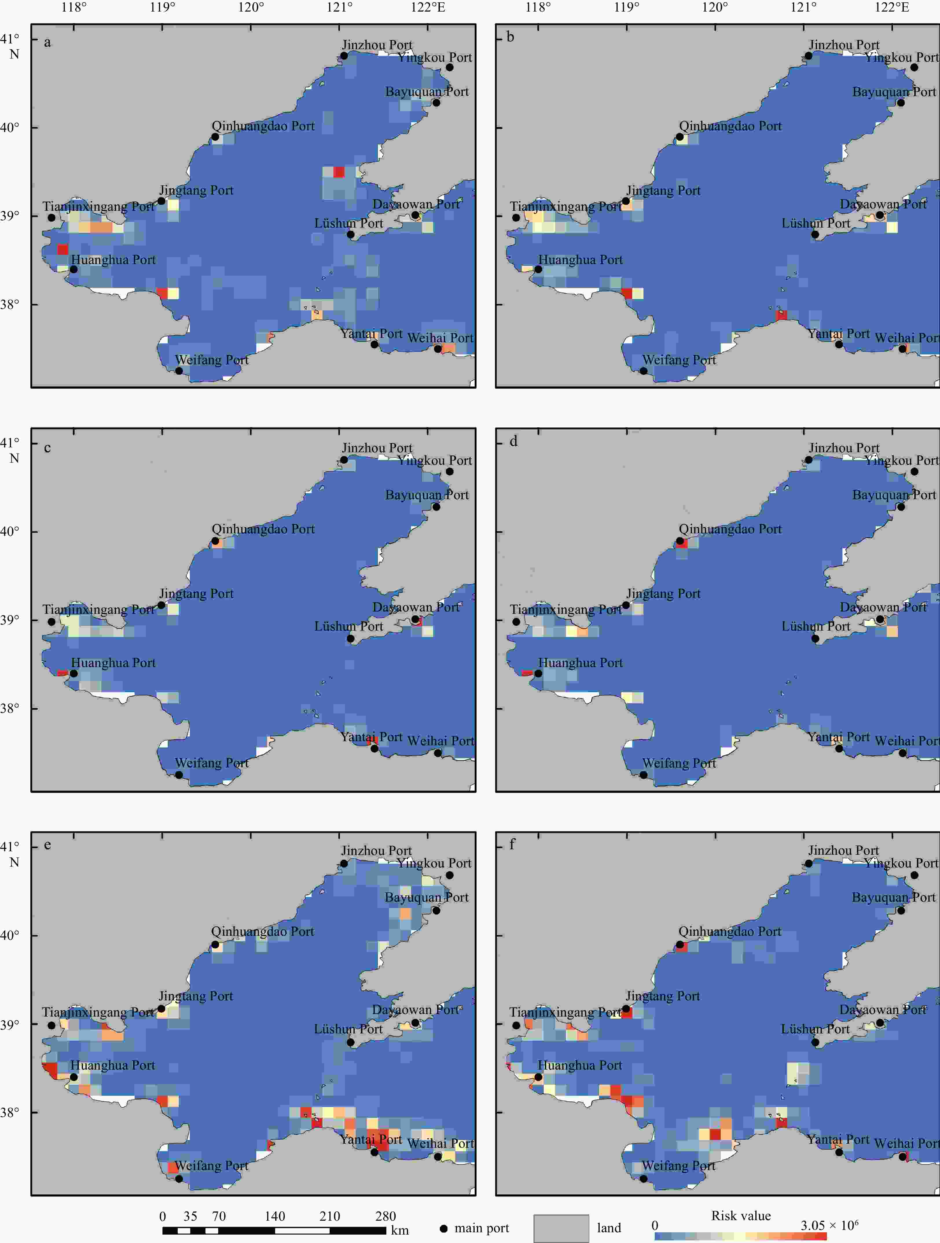
Figure 2. Spatial distribution of near-miss collision risk calculated according to the VCRO model: a. fog season, 2016, b. non-fog season, 2016, c. fog season, 2017, d. non-fog season, 2017, e. fog season, 2018, and f. non-fog season, 2018. The blue in each grid cell indicates the low risk value and the red represents high risk value.

Figure 3. Spatial distribution of sea fog in the Bohai Sea: a. April 2016, b. July 2016, c. April 2017, d. July 2017, e. April 2018, and f. July 2018.
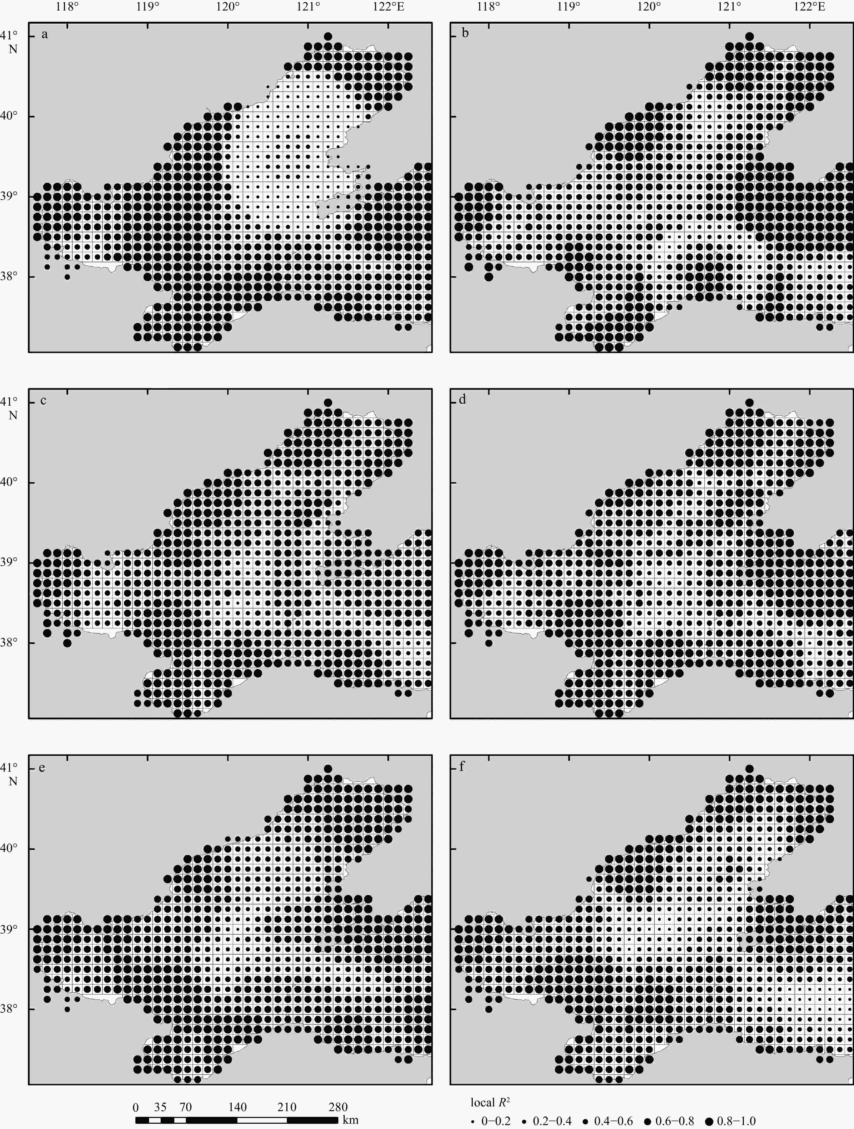
Figure 4. Local R2 of geographically weighted regression (GWR): a. fog season, 2016; b. non-fog season, 2016; c. fog season, 2017; d. non-fog season, 2017; e. fog season, 2018; and f. non-fog season, 2018.

Figure 5. Standardized residuals of geographically weighted regression (GWR): a. fog season, 2016; b. non-fog season, 2016; c. fog season, 2017; d. non-fog season, 2017; e. fog season, 2018; and f. non-fog season, 2018.

Figure 6. Local coefficient estimation of sea fog in the geographically weighted regression (GWR): a. fog season, 2016; b. non-fog season, 2016; c. fog season, 2017; d. non-fog season, 2017; e. fog season, 2018; and f. non-fog season, 2018.

Figure 7. Channel area division process: a. simplified shipping routes and points; b. Thiessen polygon using Delaunay triangulation method with route points as the source; c. shipping route areas after merging and trimming; d. channel areas with letters.
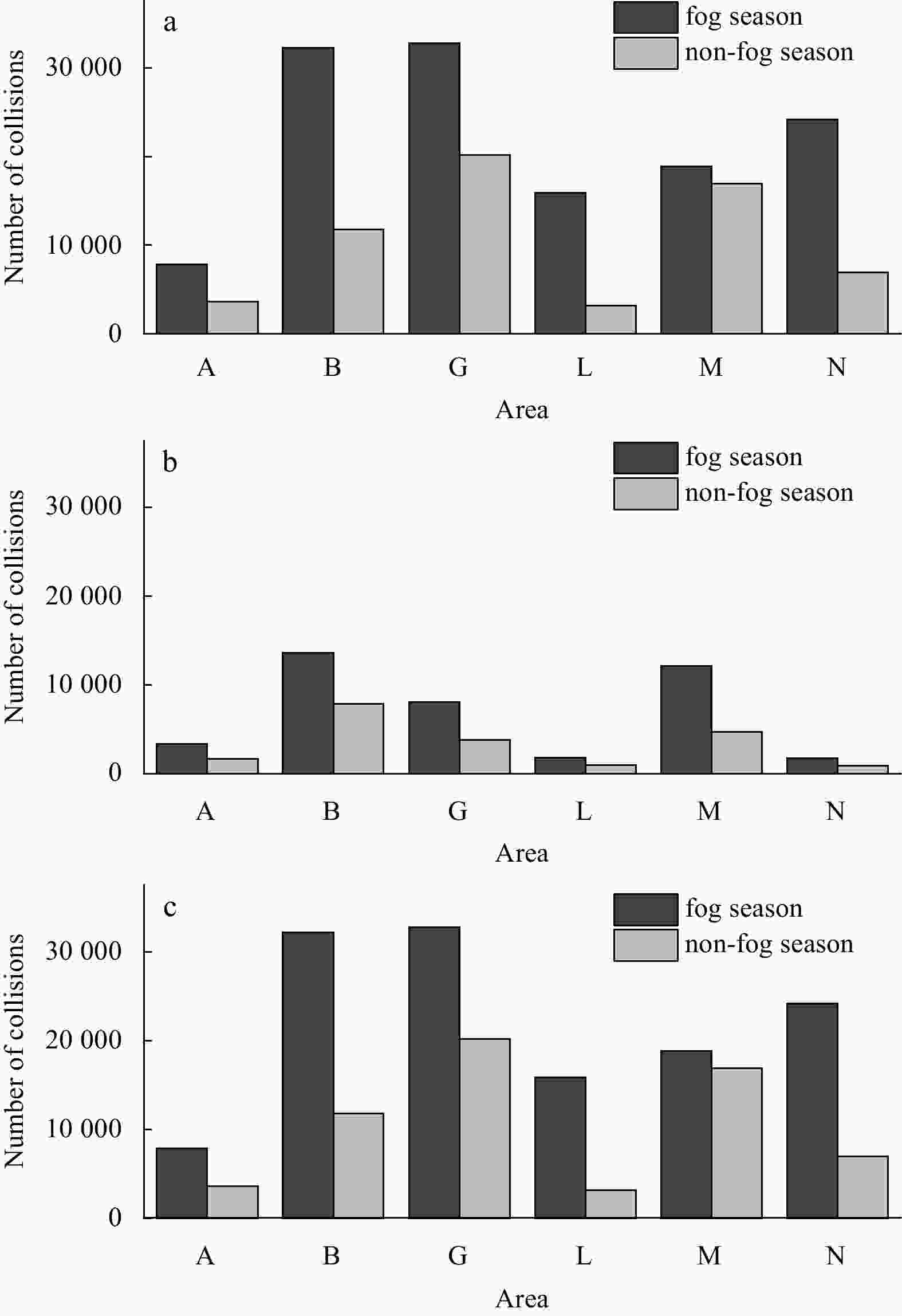
Figure 8. Number of near-miss collisions in the six navigation areas: a. fog season and non-fog season in 2016, b. fog season and non-fog season in 2017, c. fog season and non-fog season in 2018.
Table 1. Data information
Name Data description Time Purpose AHI
imagesremote sensing images
from the AHI sensorApril and
July from
2016 to 2018sea fog identification
and calculating the
frequency of monthly
sea fogAIS
datadynamic information
and static information
of ship navigationApril and
July from
2016 to 2018near miss collision
risk detection and
calculating the risk
monthly 下载: 导出CSV
Table 2. Near-miss collisions in the Bohai Sea
Year Time (fog or non-fog) Number of near-miss
collisionsPercentage
of total2016 fog season 504 983 28.7% non-fog season 421 338 24.0% 2017 fog season 242 690 13.8% non-fog season 136 348 7.8% 2018 fog season 265 872 15.1% non-fog season 186 165 10.6%
下载: 导出CSV
Table 3. Global Moran’s I statistics for near-miss collision risk
Year Time (fog or non-fog) Moran’s I z-score p-value 2016 fog season 0.158 8.142 0 non-fog season 0.147 7.549 0 2017 fog season 0.161 8.300 0 non-fog season 0.291 14.885 0 2018 fog season 0.197 10.106 0 non-fog season 0.208 10.686 0
下载: 导出CSV
Table 4. Global Moran’s I statistics for sea fog
Year Month Moran’s I z-score p-value 2016 April 0.334 12.449 0 July 0.216 8.044 0 2017 April 0.429 15.961 0 July 0.133 4.997 0 2018 April 0.443 16.445 0 July 0.207 7.710 0
下载: 导出CSV
Table 5. Geographically weighted regression (GWR) results from 2016 to 2018
Time (fog or non-fog) AICc Bandwidth/(°) Residual sum of squares R2 Adjusted R2 Fog season, 2016 18269.587 0.395 2.883 × 10¹² 0.793 0.746 Non-fog season, 2016 13202.083 0.318 2.245 × 10⁹ 0.770 0.691 Fog season, 2017 16444.070 0.362 2.208 × 10¹¹ 0.962 0.952 Non-fog season, 2017 12608.715 0.312 9.665 × 10⁸ 0.828 0.767 Fog season, 2018 16384.167 0.359 1.997 × 10¹¹ 0.913 0.890 Non-fog season, 2018 13117.846 0.333 2.056 × 10⁹ 0.790 0.723 Note: AICc represents Akaike’s Information Criterion with correction. AICc is a model selection criterion that measures the relative quality or fitness of different statistical models. The lower the AICc value, the better the model is considered to fit the data.
下载: 导出CSV
Table 6. Residuals of global Moran’s I spatial autocorrelation
Time (fog or non-fog) Moran’s I z-score p-value Fog season, 2016 0.022 0.877 0.380 Non-fog season, 2016 –0.021 –0.754 0.451 Fog season, 2017 –0.021 –0.741 0.459 Non-fog season, 2017 –0.013 –0.423 0.673 Fog season, 2018 –0.020 –0.692 0.489 Non-fog season, 2018 0.021 0.847 0.397
下载: 导出CSV
-
Brunsdon C, Fotheringham A S, Charlton M E. 1996. Geographically weighted regression: a method for exploring spatial nonstationarity. Geographical Analysis, 28(4): 281–298 Burnett A. 1996. A Guide to the Collision Avoidance Rules (Fifth edition). In: Cockcroft A N, Lameijer J N F. Butterworth–Heinemann, Oxford: The Journal of Navigation, 49(3): 455–456 Cockcroft A N, Lameijer J N F. 1996. A Guide to the Collision Avoidance Rules. 5th ed. Oxford: Butterworth-Heinemann Press, 455–456 Celik M, Lavasani S M, Wang Jin. 2010. A risk-based modelling approach to enhance shipping accident investigation. Safety Science, 48(1): 18–27. doi: 10.1016/j.ssci.2009.04.007 Chen Pengfei, Huang Yamin, Mou Junmin, et al. 2019. Probabilistic risk analysis for ship-ship collision: state-of-the-art. Safety Science, 117: 108–122. doi: 10.1016/j.ssci.2019.04.014 Cho Y K, Kim M O, Kim B C. 2000. Sea fog around the Korean peninsula. Journal of Applied Meteorology, 39(12): 2473–2479. doi: 10.1175/1520-0450(2000)039<2473:SFATKP>2.0.CO;2 Du Pei, Zeng Zhe, Zhang Jingwei, et al. 2021. Fog season risk assessment for maritime transportation systems exploiting Himawari-8 data: a case study in Bohai Sea, China. Remote Sensing, 13(17): 3530. doi: 10.3390/rs13173530 Eyre J R, Brownscombe J L, Allam R J, et al. 1984. Detection of fog at night using Advanced Very High Resolution Radiometer (AVHRR) imagery. Meteorological Magazine, 113(1346): 266–271 Fang Zhixiang, Yu Hongchu, Ke Ranxuan, et al. 2019. Automatic identification system-based approach for assessing the near-miss collision risk dynamics of ships in ports. IEEE Transactions on Intelligent Transportation Systems, 20(2): 534–543. doi: 10.1109/TITS.2018.2816122 Fotheringham A S, Yang Wenbai, Kang Wei. 2017. Multiscale geographically weighted regression (MGWR). Annals of the American Association of Geographers, 107(6): 1247–1265. doi: 10.1080/24694452.2017.1352480 Gao Yuan, Jiang Guoyou. 2018. Research on influencing factors and countermeasures of fog navigation in Weihai Harbour. In: Proceedings of the 2018 5th International Conference on Education, Management, Arts, Economics and Social Science. Sanya: Atlantis Press, 1081–1083 Gluver H. 2017. Ship Collision Analysis: Proceedings of the International Symposium on Advances in Ship Collision Analysis, Copenhagen, Denmark, 10−13 May 1998. London, UK: Routledge Hao Zengzhou, Pan Delu, Gong Fang, et al. 2009. Sea fog characteristics based on MODIS data and streamer model. In: Proceedings of SPIE 7475, Remote Sensing of Clouds and the Atmosphere XIV. Berlin: SPIE, 312–319 Harel O. 2009. The estimation of R2 and adjusted R2 in incomplete data sets using multiple imputation. Journal of Applied Statistics, 36(10): 1109–1118. doi: 10.1080/02664760802553000 Hazell E C, Rinner C. 2020. The impact of spatial scale: exploring urban butterfly abundance and richness patterns using multi-criteria decision analysis and principal component analysis. International Journal of Geographical Information Science, 34(8): 1648–1681. doi: 10.1080/13658816.2019.1675072 Heo K Y, Park S, Ha K J, et al. 2014. Algorithm for sea fog monitoring with the use of information technologies. Meteorological Applications, 21(2): 350–359. doi: 10.1002/met.1344 International Maritime Organization Maritime Safety Committee. 1998. Recommendation on performance standards for a universal shipborne automatic identification system (AIS), Resolution MSC.74(69). https://wwwcdn.imo.org/localresources/en/OurWork/Safety/Documents/AIS/Resolution%20MSC.74(69).pdf [1998-05-12/2022-10-01] Juszkiewicz W. 2016. Verification of the accuracy requirements for relative course and closest point of approach. Scientific Journals Maritime University of Szczecin, 45(117): 108–113 Karahalios H. 2014. The contribution of risk management in ship management: the case of ship collision. Safety Science, 63: 104–114. doi: 10.1016/j.ssci.2013.11.004 Kim K I, Jeong J S, Lee B G. 2017. Study on the analysis of near-miss ship collisions using logistic regression. Journal of Advanced Computational Intelligence and Intelligent Informatics, 21(3): 467–473. doi: 10.20965/jaciii.2017.p0467 Lewison G R G. 1980. The estimation of collision risk for marine traffic in UK waters. The Journal of Navigation, 33(3): 317–328. doi: 10.1017/S037346330004073X Lu Binbin, Brunsdon C, Charlton M, et al. 2017. Geographically weighted regression with parameter-specific distance metrics. International Journal of Geographical Information Science, 31(5): 982–998. doi: 10.1080/13658816.2016.1263731 Maritime Safety Administration of the People’s Republic of China. 2018. Sailing Direction on Chinese Coast: North Area. Beijing: China Communications Press Co., Ltd., 27–198 Moran P A P. 1948. The interpretation of statistical maps. Journal of the Royal Statistical Society: Series B (Methodological), 10(2): 243–251. doi: 10.1111/j.2517-6161.1948.tb00012.x Pietrzykowski Z, Uriasz J. 2009. The ship domain—a criterion of navigational safety assessment in an open sea area. The Journal of Navigation, 62(1): 93–108. doi: 10.1017/S0373463308005018 Ryu Han-Sol, Hong S. 2020. Sea fog detection based on Normalized Difference Snow Index using advanced Himawari imager observations. Remote Sensing, 12(9): 1521. doi: 10.3390/rs12091521 Rømer H, Petersen H J S, Haastrup P. 1995. Marine accident frequencies—review and recent empirical results. The Journal of Navigation, 48(3): 410–424. doi: 10.1017/S037346330001290X Store R, Jokimäki J. 2003. A GIS-based multi-scale approach to habitat suitability modeling. Ecological Modelling, 169(1): 1–15. doi: 10.1016/S0304-3800(03)00203-5 Szlapczynski R, Szlapczynska J. 2021. A ship domain-based model of collision risk for near-miss detection and Collision Alert Systems. Reliability Engineering & System Safety, 214: 107766 United Nations Conference on Trade and Development. 2017. Review of Maritime Transport 2017. Switzerland: United Nations van Iperen W H. 2015. Classifying ship encounters to monitor traffic safety on the North Sea from AIS Data. TransNav: the International Journal on Marine Navigation and Safety of Sea Transportation, 9(1): 51–58. doi: 10.12716/1001.09.01.06 Wu Xing, Aesha L. Mehta, Victor A. Zaloom, et al 2016. Analysis of waterway transportation in Southeast Texas waterway based on AIS data. Ocean Engineering, 121: 196–209. doi: 10.1016/j.oceaneng.2016.05.012 Wu Xiaojing, Li Sanmei. 2014. Automatic sea fog detection over Chinese adjacent oceans using Terra/MODIS data. International Journal of Remote Sensing, 35(21): 7430–7457. doi: 10.1080/01431161.2014.968685 Wu Xiaojing, Li Sanmei, Liao Mi, et al. 2015. Analyses of seasonal feature of sea fog over the Yellow Sea and Bohai Sea based on the recent 20 years of satellite remote sensing data. Haiyang Xuebao (in Chinese), 37(1): 63–72 Wu Dong, Lu Bo, Zhang Tianche, et al. 2015. A method of detecting sea fogs using CALIOP data and its application to improve MODIS-based sea fog detection. Journal of Quantitative Spectroscopy and Radiative Transfer, 153: 88–94. doi: 10.1016/j.jqsrt.2014.09.021 Xiao Yanfang, Zhang Jie, Qin Ping. 2019. An algorithm for daytime sea fog detection over the Greenland Sea based on MODIS and CALIOP data. Journal of Coastal Research, 90(sp1): 95–103. doi: 10.2112/SI90-012.1 Xu Mengqiu, Wu Ming, Guo Jun, et al. 2022. Sea fog detection based on unsupervised domain adaptation. Chinese Journal of Aeronautics, 35(4): 415–425. doi: 10.1016/j.cja.2021.06.019 Yoo S L. 2018. Near-miss density map for safe navigation of ships. Ocean Engineering, 163: 15–21. doi: 10.1016/j.oceaneng.2018.05.065 Zhang Weibin, Goerlandt F, Kujala P, et al. 2016. An advanced method for detecting possible near miss ship collisions from AIS data. Ocean Engineering, 124: 141–156. doi: 10.1016/j.oceaneng.2016.07.059 Zhang Weibin, Goerlandt F, Montewka J, et al. 2015. A method for detecting possible near miss ship collisions from AIS data. Ocean Engineering, 107: 60–69. doi: 10.1016/j.oceaneng.2015.07.046 Zhang Weibin, Kopca C, Tang Jinjun, et al. 2017. A systematic approach for collision risk analysis based on AIS data. The Journal of Navigation, 70(5): 1117–1132. doi: 10.1017/S0373463317000212 -


 点击查看大图

计量
- 文章访问数: 339
- HTML全文浏览量: 135
- PDF下载量: 14
- 被引次数: 0

