

Three-dimensional thermohaline structure estimation derived from HY-2 satellite data over the Maritime Silk Road and its applications
-
Abstract: Estimated ocean subsurface fields derived from satellite observations provide potential data sources for operational marine environmental monitoring and prediction systems. This study employs a statistic regression reconstruction method, in combination with domestic autonomous sea surface height and sea surface temperature observations from the Haiyang-2 (HY-2) satellite fusion data, to establish an operational quasi-real-time three-dimensional (3D) temperature and salinity products over the Maritime Silk Road. These products feature a daily temporal resolution and a spatial resolution of 0.25° × 0.25° and exhibit stability and continuity. We have demonstrated the accuracy of the reconstructed thermohaline fields in capturing the 3D thermohaline variations through comprehensive statistical evaluations, after comparing them against Argo observations and ocean analysis data from 2022. The results illustrate that the reconstructed fields effectively represent seasonal variations in oceanic subsurface structures, along with structural changes resulting from mesoscale processes, and the upper ocean’s responses to tropical cyclones. Furthermore, the incorporation of HY-2 satellite observations notably enhances the accuracy of temperature and salinity reconstructions in the Northwest Pacific Ocean and marginally improves salinity reconstruction accuracy in the North Indian Ocean when compared to the World Ocean Atlas 2018 monthly climatology thermohaline fields. As a result, the reconstructed product holds promise for providing quasi-real-time 3D temperature and salinity field information to facilitate fast decision-making during emergencies, and also offers foundational thermohaline fields for operational ocean reanalysis and forecasting systems. These contributions enhance the safety and stability of ocean subsurface activities and navigation.
-

Figure 1. Spatial coverage of the operational reconstruction system. The shaded parts are the altitude in the Maritime Silk Road. The black dots are the locations of Argo observation profiles for 2022. The red line is the trajectory of an Argo buoy (No. 5906510) between May 7, 2022, and December 31, 2022, with a black five-pointed star indicating the observation’s starting point.
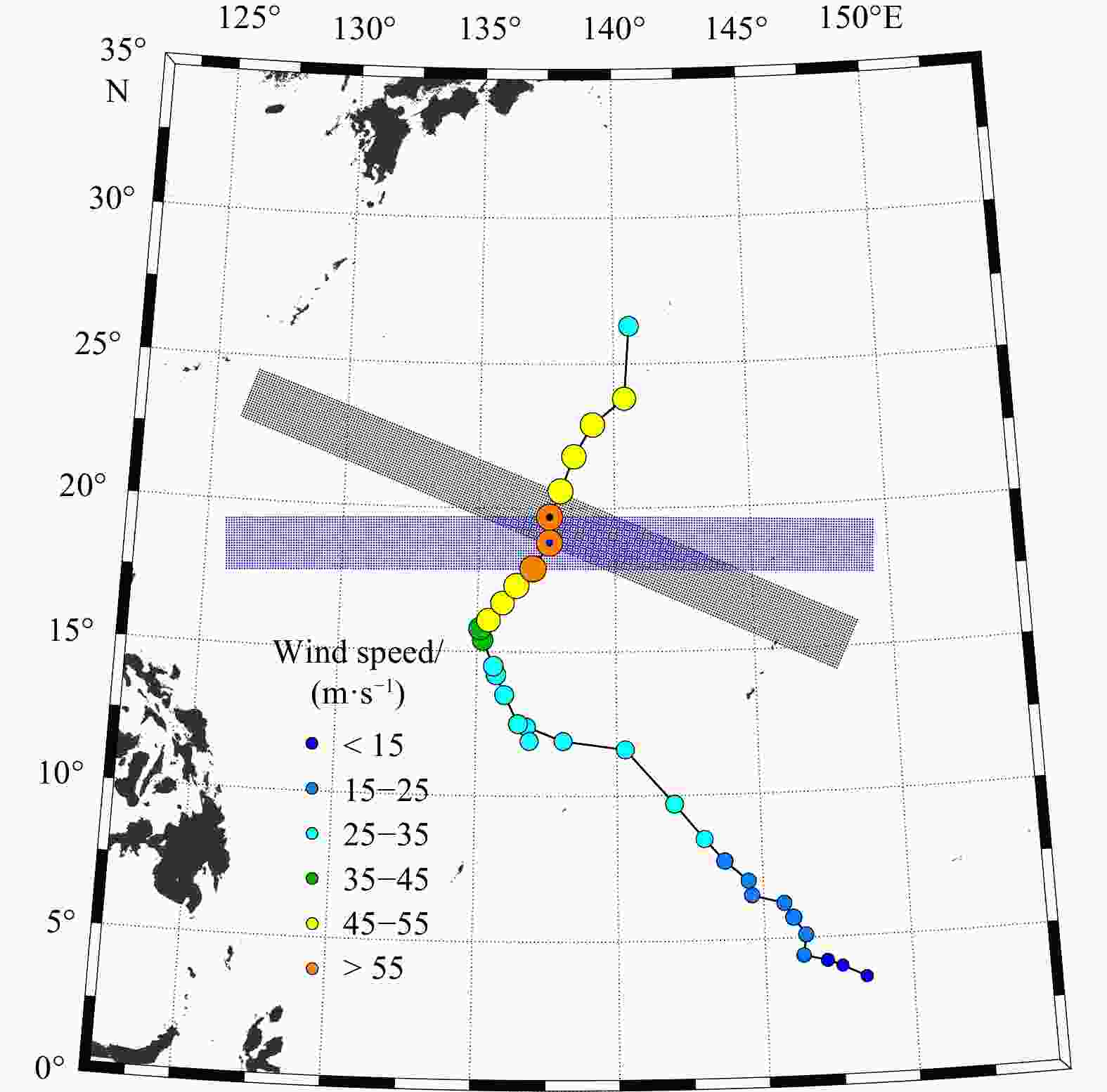
Figure 2. Schematic of the method used to calculate the tropical cyclones (TC)-induced upper oceanic temperature anomalies. The black shaded part represents the study area employed for spatial composite centered on the TC location (the black dot). The spatial resolution of the grid points in this region is 10 km × 10 km. The blue-shaded part, centered around the blue dot, is the same as the black-shaded part, but for an earlier time. The colored dots are the track points at 6 h intervals for TC Malakas in 2022. The size and color of the dots are determined by the TC maximum wind speed (unit: m/s).
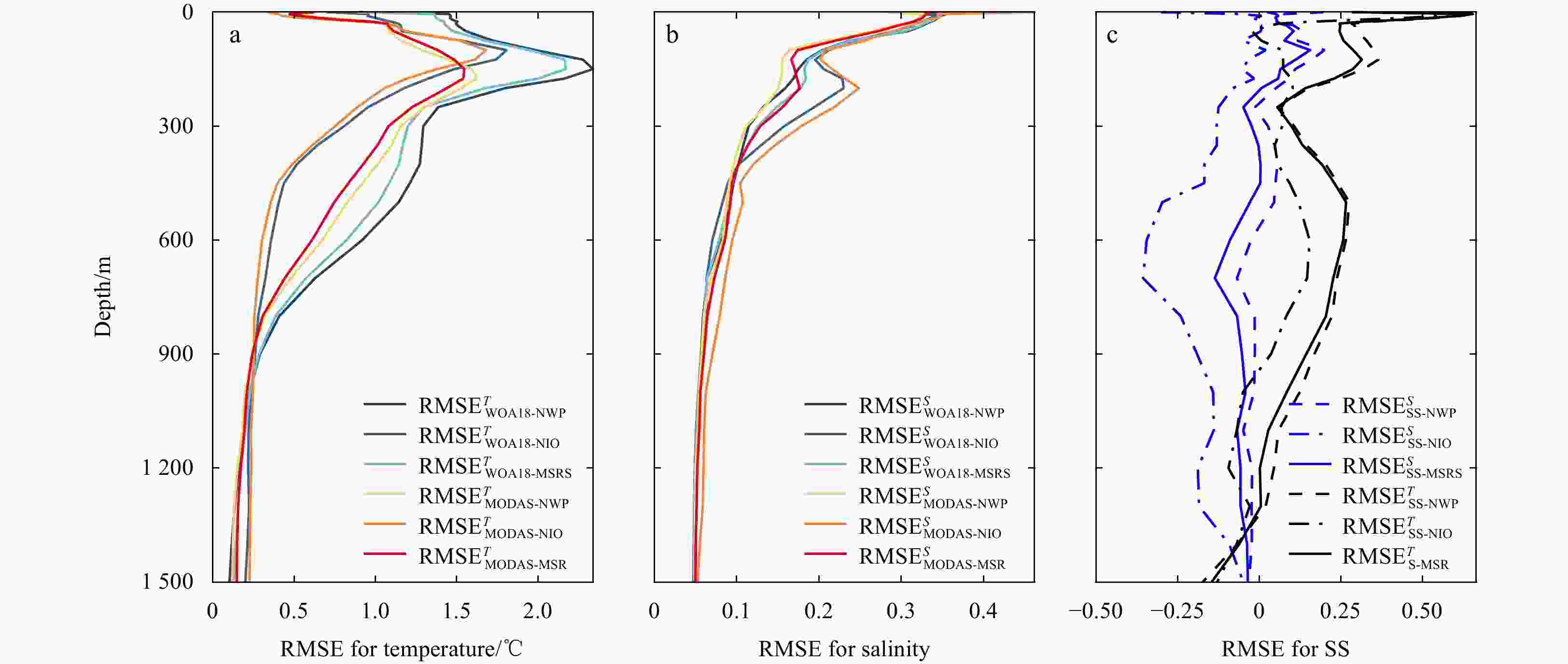
Figure 3. Vertical distributions of root mean square errors (RMSEs) for temperature (a) and salinity (b) of MODAS-reconstructed and WOA18 monthly climatology field in various ocean basins, and the vertical distributions of SS for the reconstructed temperature (black lines) and salinity (blue lines) fields in the NWP, NIO, and MSR, respectively (c). MODAS, Modular Ocean Data Assimilation System; WOA18, World Ocean Atlas 2018; NWP, Northwest Pacific Ocean; NIO, North Indian Ocean; MSR, Maritime Silk Road.
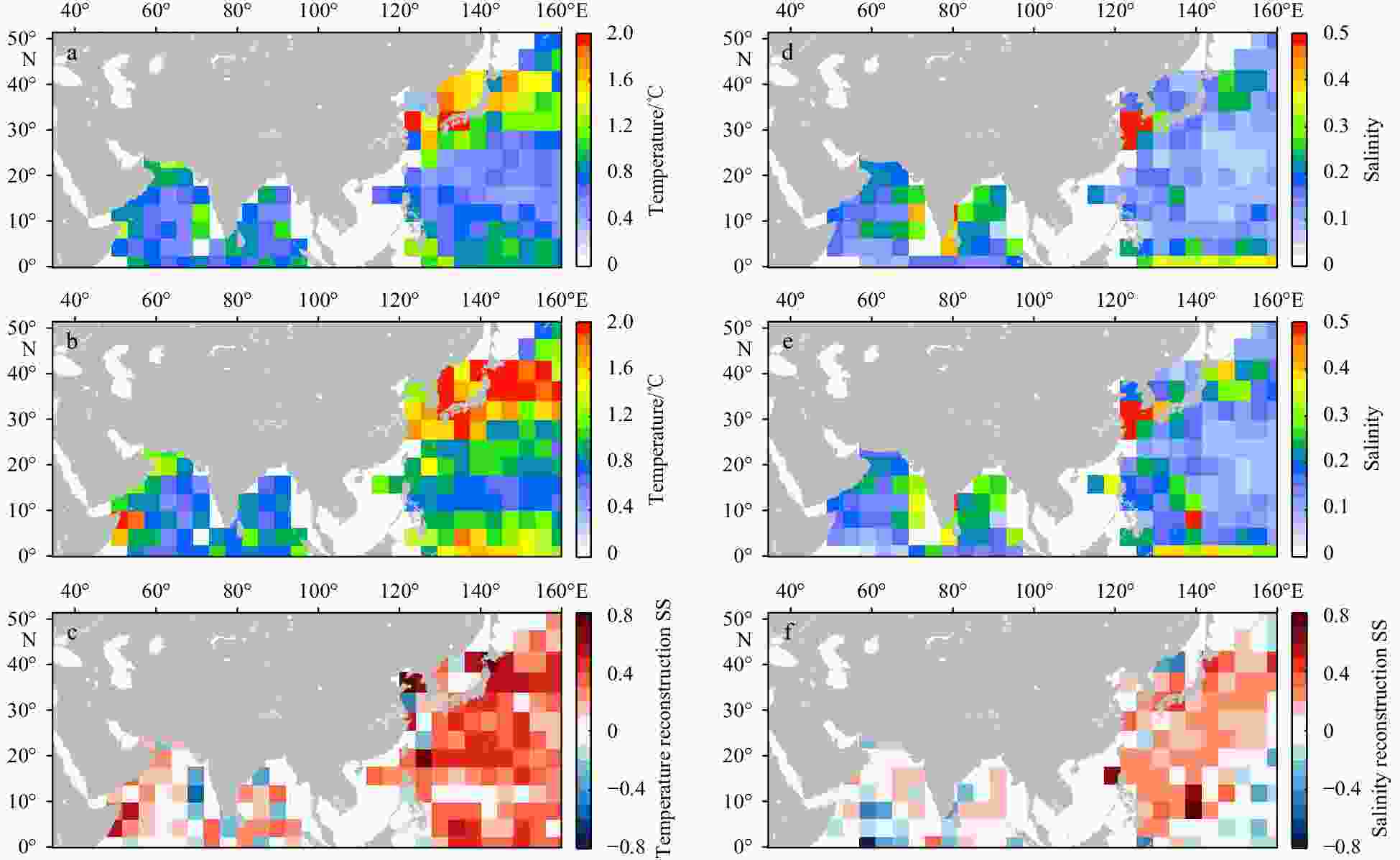
Figure 4. Spatial distributions of RMSET of MODAS-reconstructed (a) and WOA18 (b) monthly climatology temperature fields in every 4° × 4° bin, spatial distribution of temperature reconstruction SS in every 4° × 4° bin (c), and spatial distributions of RMSES of MODAS-reconstructed (d) and WOA18 (e) monthly climatology salinity fields in every 4° × 4° bin, spatial distribution of salinity reconstruction SS in every 4° × 4° bin (f). RMSE, root mean square error; MODAS, Modular Ocean Data Assimilation System; WOA18, World Ocean Atlas 2018.
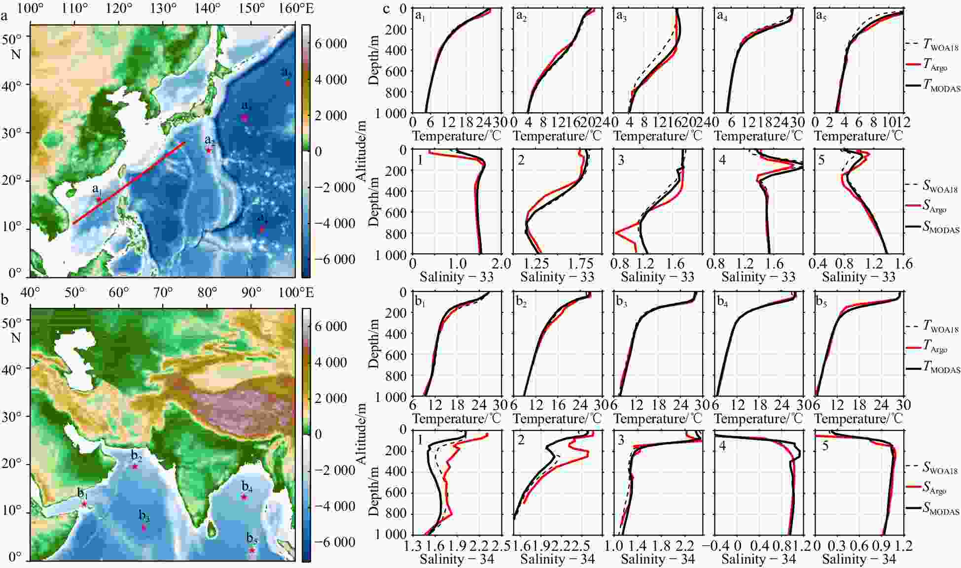
Figure 5. The altitude (shaded part) in the Northwest Pacific Ocean (a) and North Indian Ocean (b), respectively; temperature and salinity vertical profiles for the Argo observed (red lines), the MODAS reconstructed (black solid line), and the WOA18 monthly climatology (black dashed line) in the upper 1 000 m (c). The solid red line in a is the horizontal location of the vertical sections shown in Figs 6 and 7. The red five-pointed stars in a and b represent the locations of the selected Argo observation profiles. a1–a5 and b1–b5 are the mark of these profiles. The temperature and salinity vertical profiles of a1–a5 are shown in the first and second rows in c, and those of b1–b5 showing in the third and last rows in c, respectively. MODAS, Modular Ocean Data Assimilation System; WOA18, World Ocean Atlas 2018.
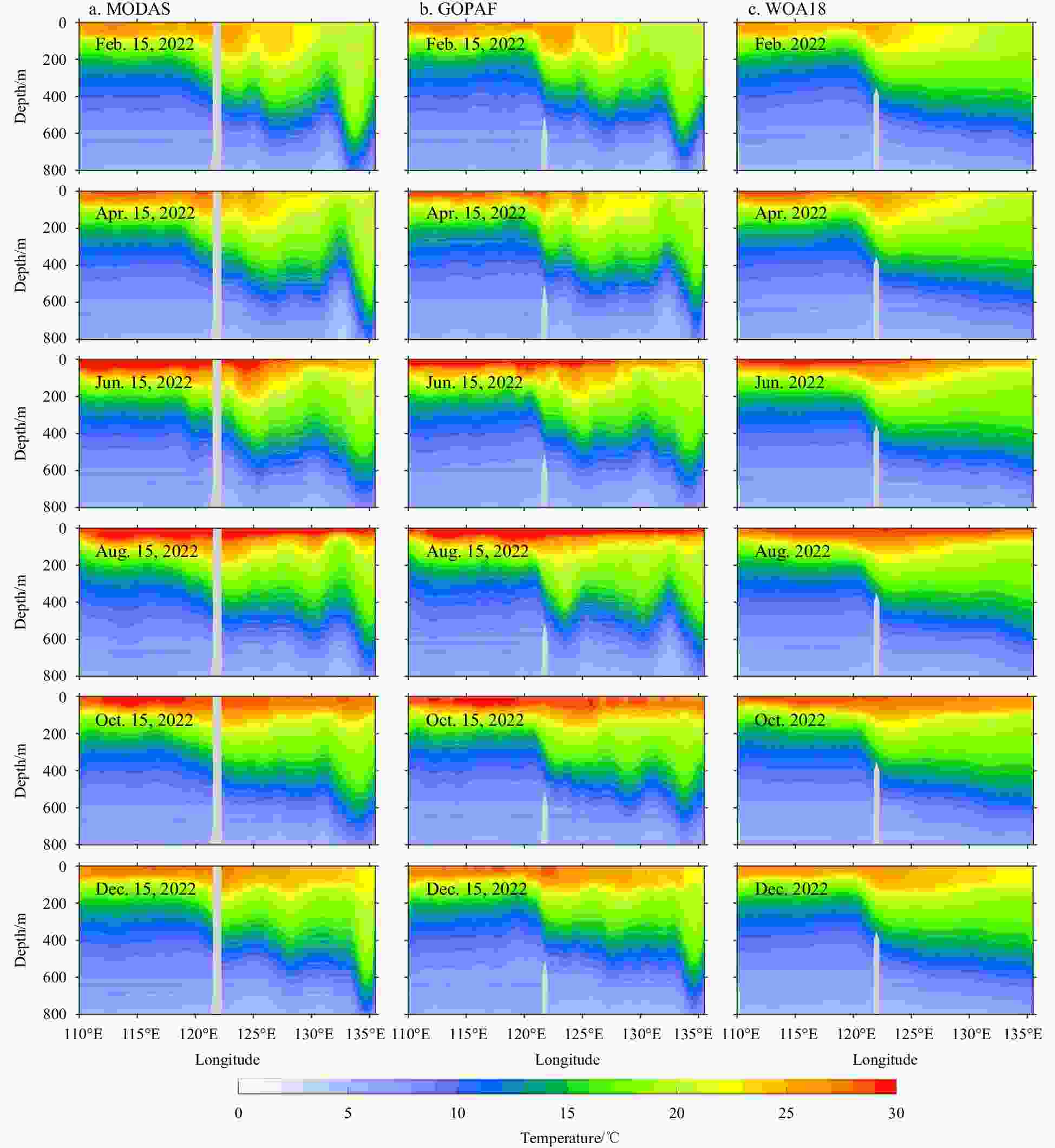
Figure 6. Vertical sections of the MODAS-reconstructed temperature field (a), the GOPAF product’s temperature field (b), and the WOA18 monthly climatology temperature field (c) on the 15th day every two months from February to December 2022. The location of these vertical sections is shown in Fig. 5. MODAS, Modular Ocean Data Assimilation System; GOPAF, global ocean physics analysis and forecast; WOA18, World Ocean Atlas 2018.
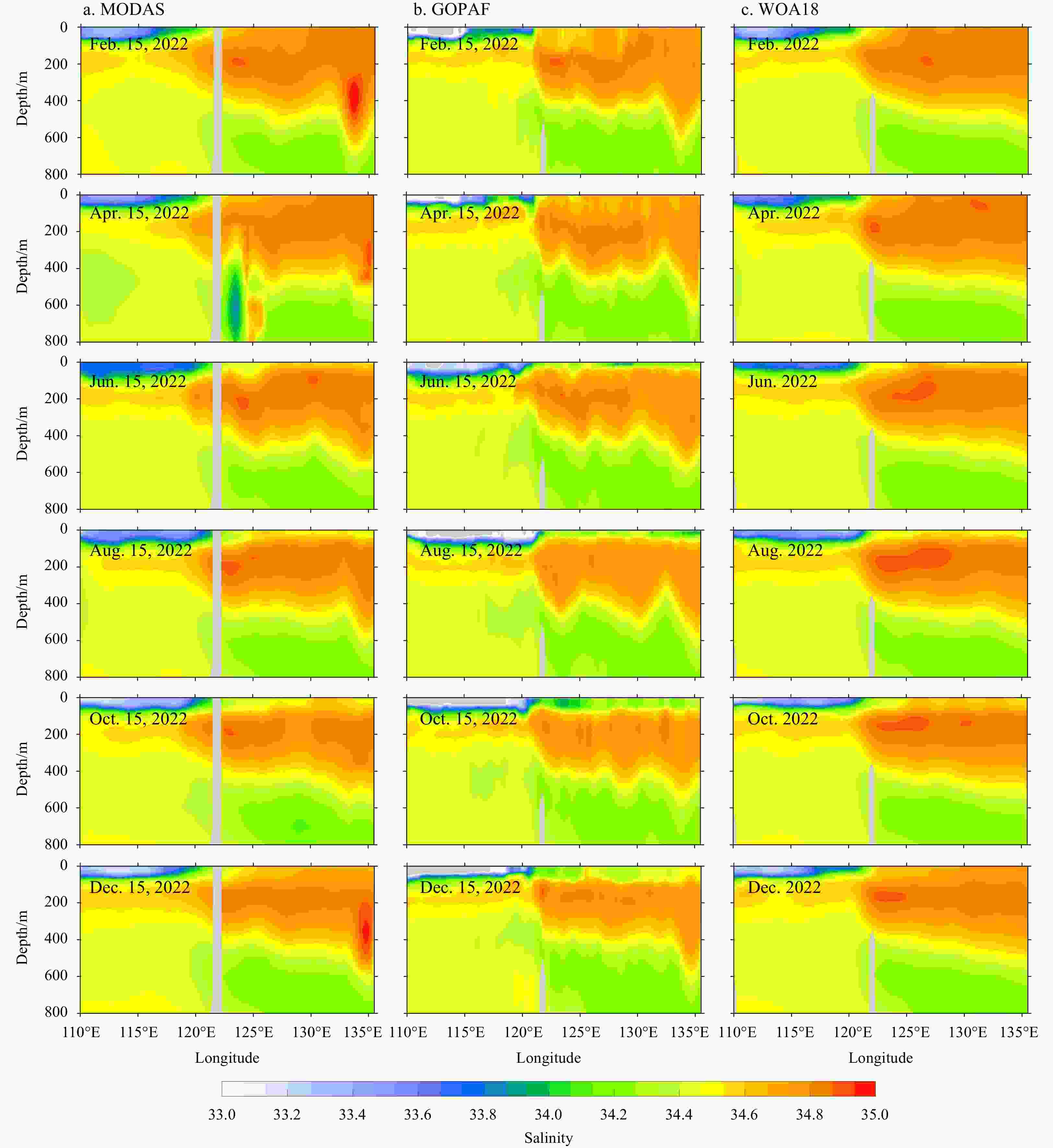
Figure 7. Vertical sections of the MODAS-reconstructed salinity field (a), the GOPAF product’s salinity field (b), and the WOA18 monthly climatology salinity field (c) on the 15th day every two months from February to December 2022. The location of the these vertical sections is shown in Fig. 5. MODAS, Modular Ocean Data Assimilation System; GOPAF, global ocean physics analysis and forecast; WOA18, World Ocean Atlas 2018.
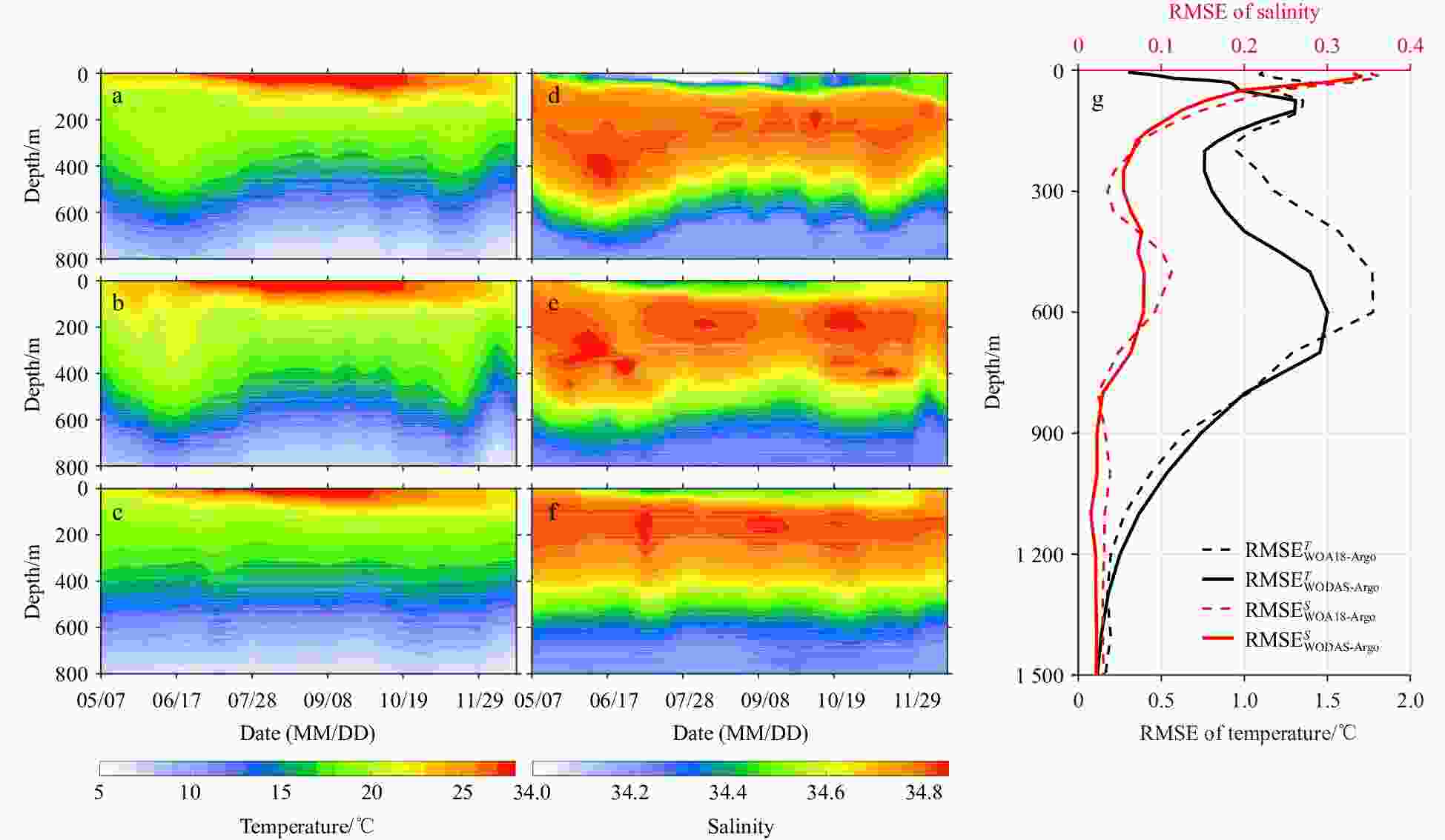
Figure 8. Vertical sections of the Argo-observed (a), the MODAS reconstructed (b), and the WOA18 monthly climatology (c) temperature as a function of depth and time; vertical sections of the Argo-observed (d), the MODAS reconstructed (e), and the WOA18 monthly climatology (f) salinity as a function of depth and time; vertical profiles of RMSET (black lines) and RMSES (red lines) for MODAS reconstructed (solid lines) and WOA18 monthly climatology fields (dashed lines) (g). MODAS, Modular Ocean Data Assimilation System; WOA18, World Ocean Atlas 2018; RMSE, root mean square error.
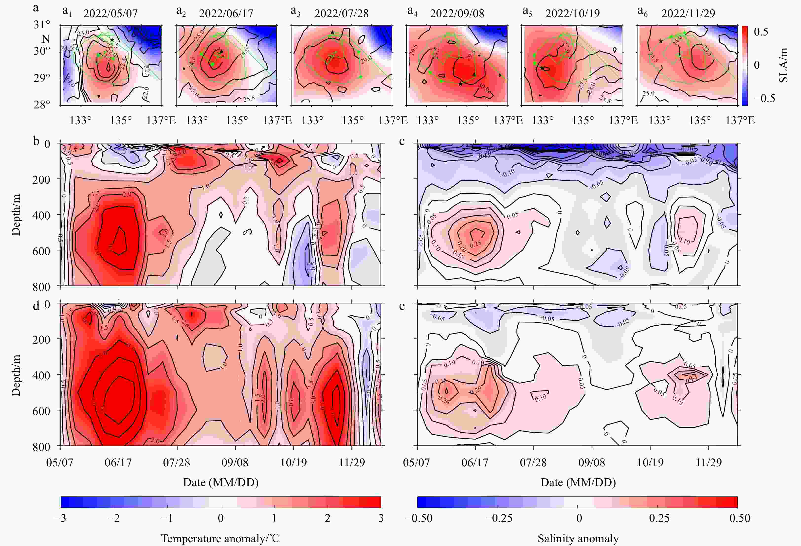
Figure 9. Partial snapshots of sea level anomalies (SLAs, shaded parts) and sea surface temperatures (SSTs, unit in ℃, black contours) during the observation period of Argo buoy No. 5906510 (a), vertical section of temperature anomaly (b) and salinity anomaly (c) of the Argo observation relative to the WOA18 monthly climatology field, and vertical section of temperature anomaly (d) and salinity anomaly (e) of the MODAS-reconstructed field relative to the WOA18 monthly climatology field. For a, the observation date is shown on the top of the subfigures, the green line is the observed trajectory of the buoy between May 7 and December 31, 2022, the green stars indicate the observed positions of the buoy during the specific month (corresponding to the month of the observation date), the black stars are the observed positions of the buoy on the observation date. WOA18, World Ocean Atlas 2018; MODAS, Modular Ocean Data Assimilation System.
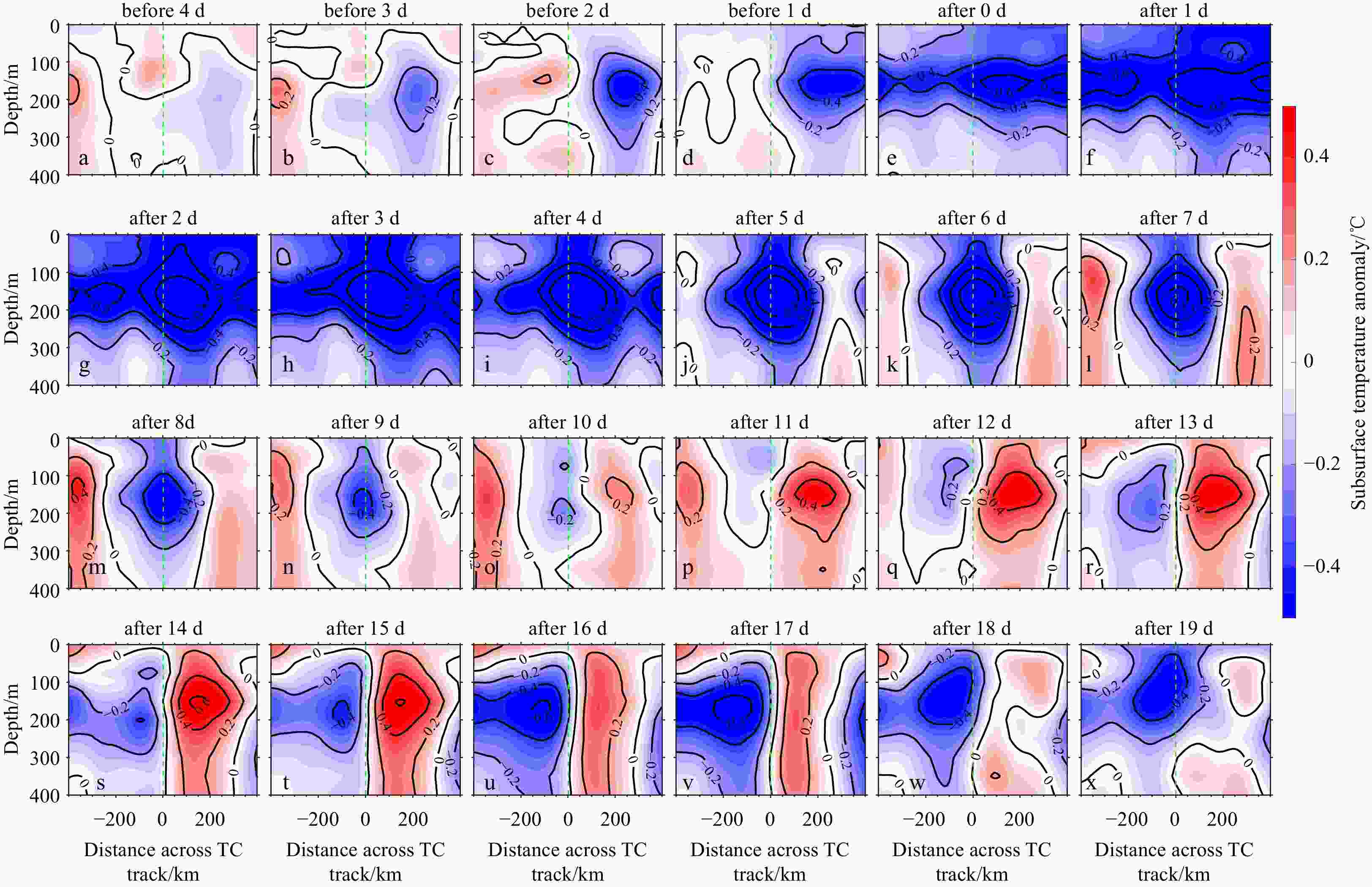
Figure 10. Subsurface temperature anomaly within 400 km across the left-hand (distance less than 0) and right-hand (distance greater than 0) sides of the typhoon track before and after the typhoon’s passage. The green dashed line indicates the eye of the tropical cyclone.
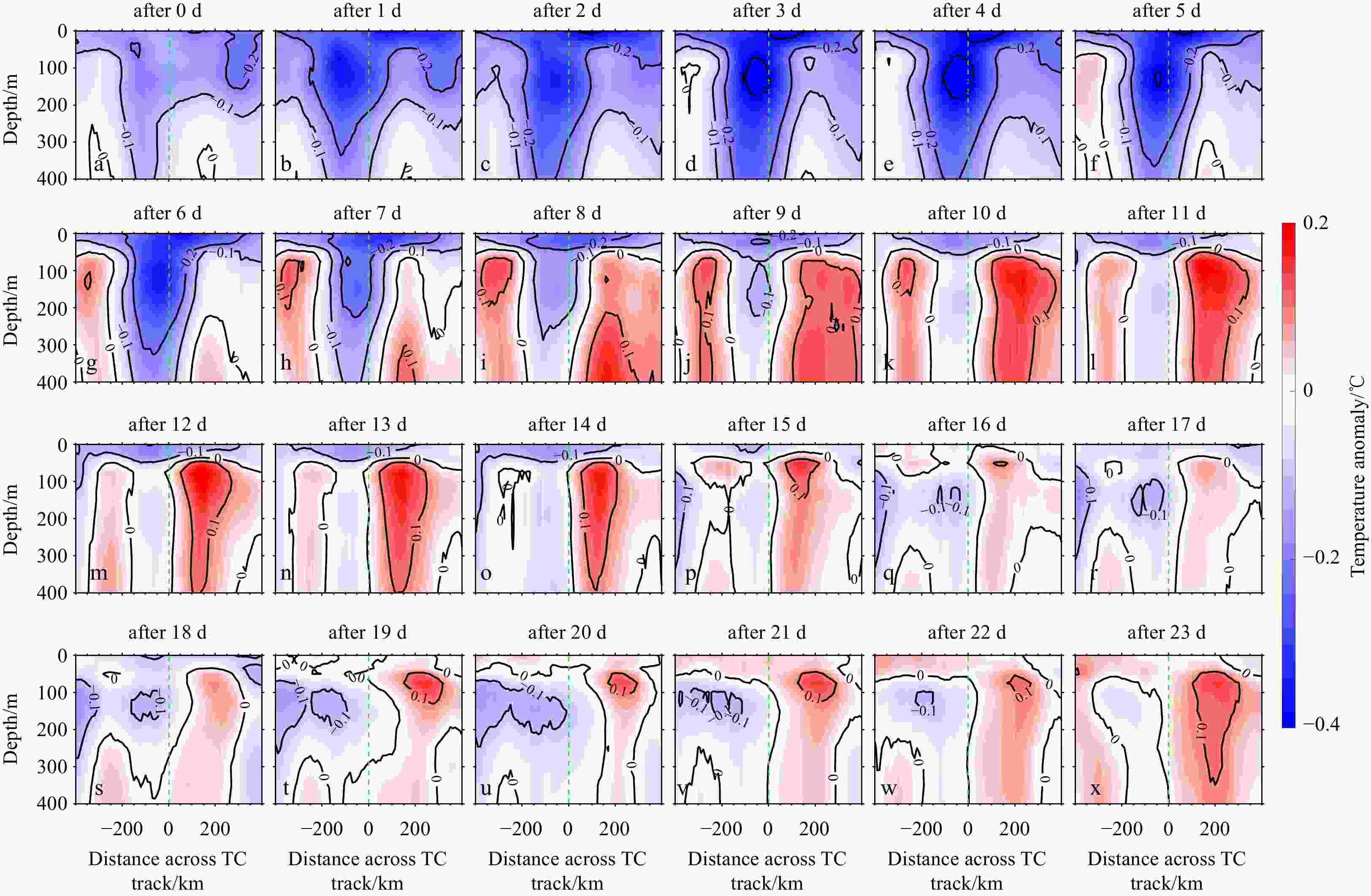
Figure 11. A composite temperature anomaly within 400 km across the left-hand (distance less than 0) and right-hand (distance greater than 0) sides before and after the typhoon’s passage for all tropical cyclones (TCs) in the North Indian Ocean in 2022. The green dashed line indicates the eye of the TC.
Table 1. The mean RMEST and RMSES of MODAS reconstructed fields at various depth ranges in different regions
Depth/m RMEST/°C RMSES MSR NWP NIO MSR NWP NIO [0, 50)
0.77
(1.33)0.79
(1.41)0.69
(1.01)0.32
(0.34)0.31
(0.34)0.35
(0.33)[50, 150)
1.35
(1.89)1.31
(1.98)1.47
(1.54)0.20
(0.22)0.19
(0.22)0.23
(0.23)[150, 300)
1.32
(1.54)1.40
(1.66)0.97
(1.07)0.16
(0.16)0.14
(0.14)0.22
(0.20)[300, 900)
0.64
(0.81)0.70
(0.90)0.37
(0.40)0.09
(0.08)0.08
(0.08)0.10
(0.08)[900, 1 500)
0.17
(0.17)0.15
(0.16)0.23
(0.22)0.05
(0.05)0.05
(0.05)0.06
(0.05)[0, 1 500]
0.79
(1.09)0.81
(1.16)0.68
(0.79)0.17
(0.17)0.16
(0.17)0.19
(0.18)Note: The mean root mean square errors (RMSEs) of WOA18 monthly climatology fields are listed in the parenthesis. MODAS, Modular Ocean Data Assimilation System; WOA18, World Ocean Atlas 2018.  下载: 导出CSV
-
Ballabrera-Poy J, Mourre B, Garcia-Ladona E, et al. 2009. Linear and non-linear T-S models for the eastern North Atlantic from Argo data: Role of surface salinity observations. Deep-Sea Research Part I: Oceanographic Research Papers, 56(10): 1605–1614, doi: 10.1016/j.dsr.2009.05.017 Ballarotta M, Ubelmann C, Veillard P, et al. 2023. Improved global sea surface height and current maps from remote sensing and in situ observations. Earth System Science Data, 15(1): 295–315, doi: 10.5194/essd-15-295-2023 Bao Senliang, Wang Huizan, Zhang Ren, et al. 2019. Comparison of satellite-derived sea surface salinity products from SMOS, aquarius, and SMAP. Journal of Geophysical Research: Oceans, 124(3): 1932–1944, doi: 10.1029/2019JC014937 Buongiorno Nardelli B, Guinehut S, Pascual A, et al. 2012. Towards high resolution mapping of 3-D mesoscale dynamics from observations. Ocean Science, 8(5): 885–901, doi: 10.5194/os-8-885-2012 Burnett W, Harper S, Preller R, et al. 2014. Overview of operational ocean forecasting in the US Navy: past, present, and future. Oceanography, 27(3): 24–31, doi: 10.5670/oceanog.2014.65 Carnes M R, Mitchell J L, De Witt P W. 1990. Synthetic temperature profiles derived from Geosat altimetry: Comparison with air-dropped expendable bathythermograph profiles. Journal of Geophysical Research: Oceans, 95(C10): 17979–17992, doi: 10.1029/JC095iC10p17979 Chen Gengxin, Hou Yijun, Chu Xiaoqing. 2011. Mesoscale eddies in the South China Sea: Mean properties, spatiotemporal variability, and impact on thermohaline structure. Journal of Geophysical Research: Oceans, 116(C6): C06018, doi: 10.1029/2010 JC006716 Chen Zhiqiang, Wang Xidong, Liu Lei. 2020. Reconstruction of three-dimensional ocean structure from sea surface data: an application of isQG method in the Southwest Indian Ocean. Journal of Geophysical Research: Oceans, 125(6): e2020jc016351, doi: 10.1029/2020JC016351 Chen Zhiqiang, Wang Xidong, Liu Lei, et al. 2023. Estimating three-dimensional structures of eddy in the South Indian Ocean from the satellite observations based on the isQG method. Earth and Space Science, 10(10): e2023EA002991, doi: 10.1029/2023 EA002991 Cheng Lijing, Zhu Jiang, Sriver R L. 2015. Global representation of tropical cyclone-induced short-term ocean thermal changes using Argo data. Ocean Science, 11(5): 719–741, doi: 10.5194/os-11-719-2015 Copernicus Marine Service. 2023. Global ocean physics analysis and forecast. https://data.marine.copernicus.eu/product/GLOBAL_ANALYSISFORECAST_PHY_001_024/description [2023-11-30/2023-12-29], doi: 10.48670/moi-00016 Dash P, Ignatov A, Martin M, et al. 2012. Group for high resolution sea surface temperature (GHRSST) analysis fields inter-comparisons—Part 2: Near real time web-based level 4 SST Quality Monitor (L4-SQUAM). Deep-Sea Research Part II: Topical Studies in Oceanography, 77–80: 31–43, doi: 10.1016/j.dsr2. 2012.04.002 Dong Changming, Xu Guangjun, Han Guoqing, et al. 2022. Recent developments in artificial intelligence in oceanography. Ocean-Land-Atmosphere Research, 2022: 9870950, doi: 10.34133/2022/9870950 Dong Chao, Chen Dake, Wang Dongxiao, et al. 2023. Intelligent swift ocean observing system. Ocean-Land-Atmosphere Research, 2: 0022., doi: 10.34133/olar.0022 Fox D N, Teague W J, Barron C N, et al. 2002. The modular ocean data assimilation system (MODAS). Journal of Atmospheric and Oceanic Technology, 19(2): 240–252, doi: 10.1175/1520-0426(2002)019<0240:TMODAS>2.0.CO;2 Guinehut S, Dhomps A L, Larnicol G, et al. 2012. High resolution 3-D temperature and salinity fields derived from in situ and satellite observations. Ocean Science, 8(5): 845–857, doi: 10.5194/os-8-845-2012 Guinehut S, Le Traon P Y, Larnicol G, et al. 2004. Combining Argo and remote-sensing data to estimate the ocean three-dimensional temperature fields—a first approach based on simulated observations. Journal of Marine Systems, 46(1–4): 85–98, doi: 10.1016/j.jmarsys.2003.11.022 He Zikang, Wang Xidong, Wu Xinrong, et al. 2021. Projecting three-dimensional ocean thermohaline structure in the North Indian Ocean from the satellite sea surface data based on a variational method. Journal of Geophysical Research: Oceans, 126(1): e2020JC016759, doi: 10.1029/2020JC016759 Huang Longyu, Yang Jingsong, Ma Zetai, et al. 2023. High-frequency observations of oceanic internal waves from geostationary orbit satellites. Ocean-Land-Atmosphere Research, 2: 0024., doi: 10.34133/olar.0024 Hurlburt H E. 1986. Dynamic transfer of simulated altimeter data into subsurface information by a numerical ocean model. Journal of Geophysical Research: Oceans, 91(C2): 2372–2400, doi: 10.1029/JC091iC02p02372 Isern-Fontanet J, Ballabrera-Poy J, Turiel A, et al. 2017. Remote sensing of ocean surface currents: A review of what is being observed and what is being assimilated. Nonlinear Processes in Geophysics, 24(4): 613–643, doi: 10.5194/npg-24-613-2017 Isern-Fontanet J, Lapeyre G, Klein P, et al. 2008. Three-dimensional reconstruction of oceanic mesoscale currents from surface information. Journal of Geophysical Research, 113(C9): C09005, doi: 10.1029/2007JC004692 Knapp K R, Kruk M C, Levinson D H, et al. 2010. The international best track archive for climate stewardship (IBTrACS): Unifying tropical cyclone data. Bulletin of the American Meteorological Society, 91(3): 363–376., doi: 10.1175/2009BAMS2755.1 Liu Lei, Peng Shiqiu, Huang Ruixin. 2017. Reconstruction of ocean’s interior from observed sea surface information. Journal of Geophysical Research: Oceans, 122(2): 1042–1056, doi: 10.1002/2016JC011927 Liu Lei, Xue Huijie. 2022. Estimating the Ocean Interior from Satellite Observations in the Kerguelen Area (Southern Ocean): A combined investigation using high-resolution CTD data from animal-borne instruments. Journal of Physical Oceanography, 52(10): 2463–2478, doi: 10.1175/JPO-D-21-0183.1 Liu Lei, Yu Xiaolong, Xue Huijie, et al. 2023. Reconstructability of open-ocean upper-layer dynamics from surface observations using surface quasigeostrophy (SQG) theory. Journal of Geophysical Research: Oceans, 128(12): e2023JC020124., doi: 10.1029/2023JC020124 Ma Zhanhong, Fei Jianfang, Huang Xiaogang, et al. 2018. Modulating effects of mesoscale oceanic eddies on sea surface temperature response to tropical cyclones over the Western North Pacific. Journal of Geophysical Research: Atmospheres, 123(1): 367–379., doi: 10.1002/2017JD027806 Martin M, Dash P, Ignatov A, et al. 2012. Group for high resolution sea surface temperature (GHRSST) analysis fields inter-comparisons. Part 1: A GHRSST multi-product ensemble (GMPE). Deep-Sea Research Part II: Topical Studies in Oceanography, 77–80: 21–30, doi: 10.1016/j.dsr2.2012.04.013 Mei Wei, Pasquero C. 2013. Spatial and temporal characterization of sea surface temperature response to tropical cyclones. Journal of Climate, 26(11): 3745–3765, doi: 10.1175/JCLI-D-12-00125.1 Morrow R, Fu L L, Ardhuin F, et al. 2019. Global observations of fine-scale ocean surface topography with the surface water and ocean topography (SWOT) mission. Frontiers in Marine Science, 6: 232, doi: 10.3389/fmars.2019.00232 Mulet S, Rio M H, Mignot A, et al. 2012. A new estimate of the global 3D geostrophic ocean circulation based on satellite data and in-situ measurements. Deep-Sea Research Part II: Topical Studies in Oceanography, 77–80: 70–81, doi: 10.1016/j.dsr2.2012.04.012 Nan Feng, He Zhigang, Zhou Hui, et al. 2011. Three long-lived anticyclonic eddies in the northern South China Sea. Journal of Geophysical Research: Oceans, 116(C5): C05002, doi: 10.1029/2010JC006790 National Centers for Environmental Information. 2023. WOA 2018 Data Access: Statistical mean of temperature on 1° grid for all decades. https://www.ncei.noaa.gov/products/world-ocean-atlas [2018-09-30/2023-12-29] Price J F. 1981. Upper ocean response to a hurricane. Journal of Physical Oceanography, 11(2): 153–175, doi: 10.1175/1520-0485(1981)011<0153:UORTAH>2.0.CO;2 Price J F, Sanford T B, Forristall G Z. 1994. Forced stage response to a moving hurricane. Journal of Physical Oceanography, 24(2): 233–260, doi: 10.1175/1520-0485(1994)024<0233:FSRTAM>2.0.CO;2 Qiao Fangli, Wang Guansuo, Khokiattiwong S, et al. 2019. China published ocean forecasting system for the 21st-Century Maritime Silk Road on December 10, 2018. Acta Oceanologica Sinica, 38(1): 1–3, doi: 10.1007/s13131-019-1365-y Qiu Bo, Chen Shuiming, Klein P, et al. 2014. Seasonal mesoscale and submesoscale eddy variability along the North Pacific subtropical countercurrent. Journal of Physical Oceanography, 44(12): 3079–3098, doi: 10.1175/JPO-D-14-0071.1 Riser S C, Freeland H J, Roemmich D, et al. 2016. Fifteen years of ocean observations with the global Argo array. Nature Climate Change, 6(2): 145–153, doi: 10.1038/nclimate2872 Su Hua, Lu Wenfang, Wang An, Zhang Tianyi. 2023. Al-based subsurface thermohaline structure retrieval from remote sensing observations. In: Li Xiaofeng, Wang Fan, eds, Artificial Intelligence Oceanography. Singapore: Springer Nature Singapore, 105–123, doi: 10.1007/978-981-19-6375-9_5 Tang Bo, Zhao Dandan, Cui Chaoran, et al. 2022. Reconstruction of ocean temperature and salinity profiles in the northern South China Sea using satellite observations. Frontiers in Marine Science, 9: 945835, doi: 10.3389/fmars.2022.945835 Wang Xidong, Chu P C, Han Guijun, et al. 2012a. A fully conserved minimal adjustment scheme with (T, S) coherency for stabilization of hydrographic profiles. Journal of Atmospheric and Oceanic Technology, 29(12): 1854–1865, doi: 10.1175/JTECH-D-12-00025.1 Wang Xidong, Li Wei, Qi Yiquan, et al. 2012b. Heat, salt and volume transports by eddies in the vicinity of the Luzon Strait. Deep-Sea Research Part I: Oceanographic Research Papers, 61: 21–33, doi: 10.1016/j.dsr.2011.11.006 Xie Huarong, Xu Qing, Cheng Yongcun, et al. 2022. Reconstruction of subsurface temperature field in the south china sea from satellite observations based on an attention U-Net model. IEEE Transactions on Geoscience and Remote Sensing, 60: 4209319, doi: 10.1109/TGRS.2022.3200545 Yan Hengqian, Zhang Ren, Wang Huizan, et al. 2021a. A surface quasi-geostrophic—based dynamical-statistical framework to retrieve interior temperature/salinity from ocean surface. Journal of Geophysical Research: Oceans, 126(10): e2020JC017139, doi: 10.1029/2020JC017139 Yan Hengqian, Wang Huizan, Zhang Ren, et al. 2021b. The inconsistent pairs between in situ observations of near surface salinity and multiple remotely sensed salinity data. Earth and Space Science, 8(5): e2020EA001355, doi: 10.1029/2020EA001355 Yang Yikai, Wang Dongxiao, Wang Qiang, et al. 2019. Eddy-induced transport of saline kuroshio water into the northern South China Sea. Journal of Geophysical Research: Oceans, 124(9): 6673–6687, doi: 10.1029/2018JC014847 Zhou Lei, Chen Dake, Lei Xiaotu, et al. 2019. Progress and perspective on interactions between ocean and typhoon. Chinese Science Bulletin, 64(1): 60–72, doi: 10.1360/N972018-00668 -


 点击查看大图

计量
- 文章访问数: 280
- HTML全文浏览量: 117
- PDF下载量: 12
- 被引次数: 0

