

Structural features in the mid-southern section of the Kyushu–Palau Ridge based on satellite altimetry gravity anomaly
-
Abstract: The Kyushu–Palau Ridge (KPR), an anti-S-shaped submarine highland at the center of the Philippine Sea Plate (PSP), is considered the residual arc of the Izu–Bonin–Mariana Island Arc, which retains key information about the cessation of the Western Philippine Basin (WPB) expansion and the Parece Vela Basin (PVB) breakup. Herein, using the new generation of satellite altimetry gravity data, high-precision seafloor topography data, and newly acquired ship-borne gravity data, the topographic and gravity characteristics of the KPR mid-southern section and adjacent region are depicted. The distribution characteristics of the faults were delineated using the normalized vertical derivative–total horizontal derivative method(NVDR-THDR) and the minimum curvature potential field separation method. The Moho depth and crustal thickness were inverted using the rapid inversion method for a double-interface model with depth constraints. Based on these results, the crust structure features in the KPR mid-southern section, and the “triangular” structure geological significance where the KPR and Central Basin Rift (CBR) of the WPB intersect are interpreted. The KPR crustal thickness is approximately 6–16 km, with a distinct discontinuity that is slightly thicker than the normal oceanic crust. The KPR mid-southern section crust structure was divided into four segments (S1–S4) from north to south, formed by the CBR eastward extension joint action and clockwise rotation of the PVB expansion axis and the Mindanao fault zone blocking effect.
-
Key words:
- structural features /
- satellite altimetry gravity data /
- Kyushu–Palau Ridge /
- Central Basin Rift /
- faults /
- Moho depth
-
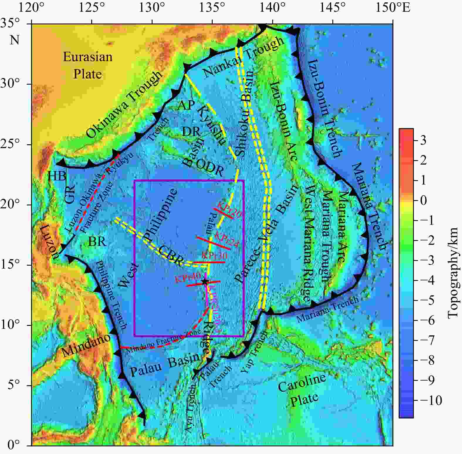
Figure 1. Tectonic setting of the Philippine Sea (Wu et al., 2016). The elevation data are taken from Smith and Sandwell (1997). The double yellow dashed lines indicate the active and inactive spreading centers and the single dashed yellow line denotes the Kyushu–Palau Ridge (KPR). The purple boxes delineate the study ranges. Solid red and pink lines indicate the positions of the deep reflection seismic profiles (Nishizawa et al., 2007; Wei et al., 2022). Dashed red lines indicate the fracture zones and transform faults. AP: Amami Plateaul; BR: Benham Rise; CBR: Central Basin Rift; DR: Daito Ridge; GR: Gagua Ridge; HB: Huatung Basin; ODR: Oki-Daito Ridge.

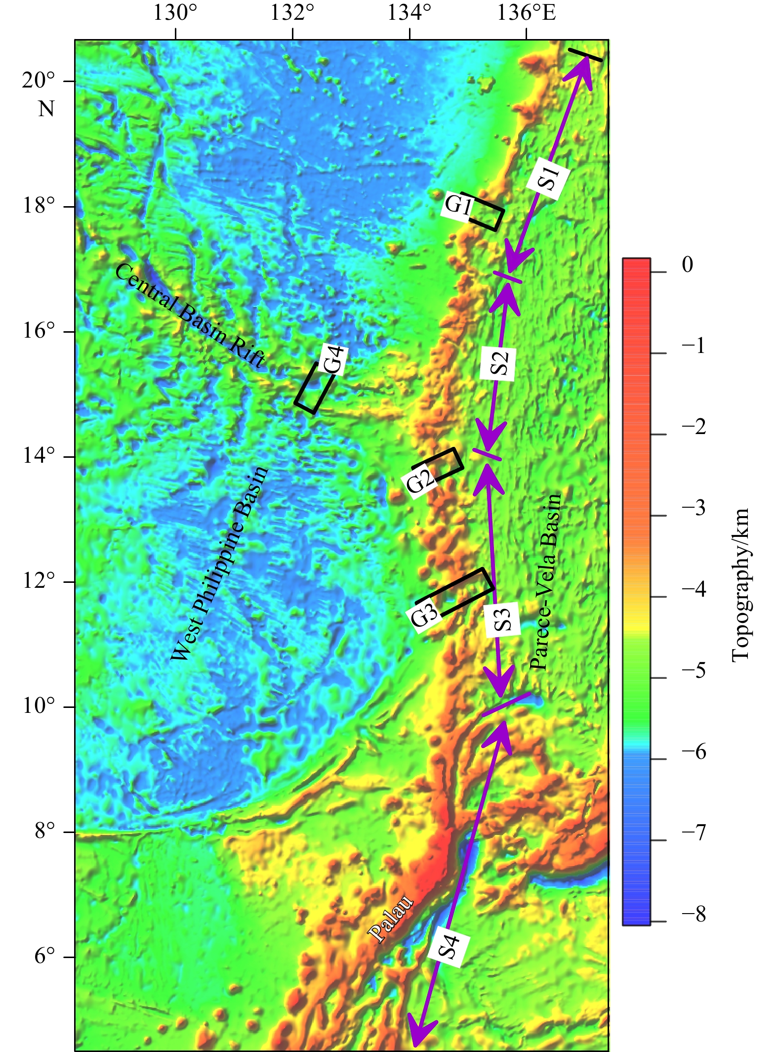
Figure 2. Seafloor topography map of the study area with data from
http:www.ngdc.noaa.gov/mgg/global/global.html . The KPR is divided into four segments (S1–S4). The black rectangles (G1–G4) represent topographic gaps, which disconnect KPR and CBR.
Figure 3. Gravity anomaly maps of the study area. a. Satellite altimetry gravity anomaly (free-air gravity anomaly). b. The Bouguer gravity anomaly.
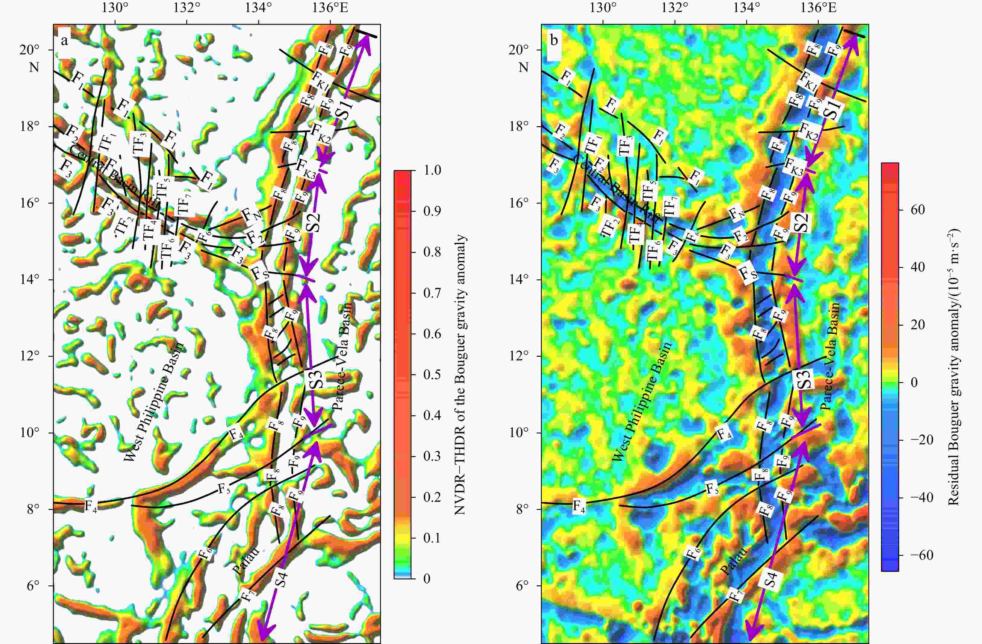
Figure 4. Distribution maps of the faults in the study area. a. NVDR-THDR results of the Bouguer gravity anomaly. b. The residual Bouguer gravity anomaly.
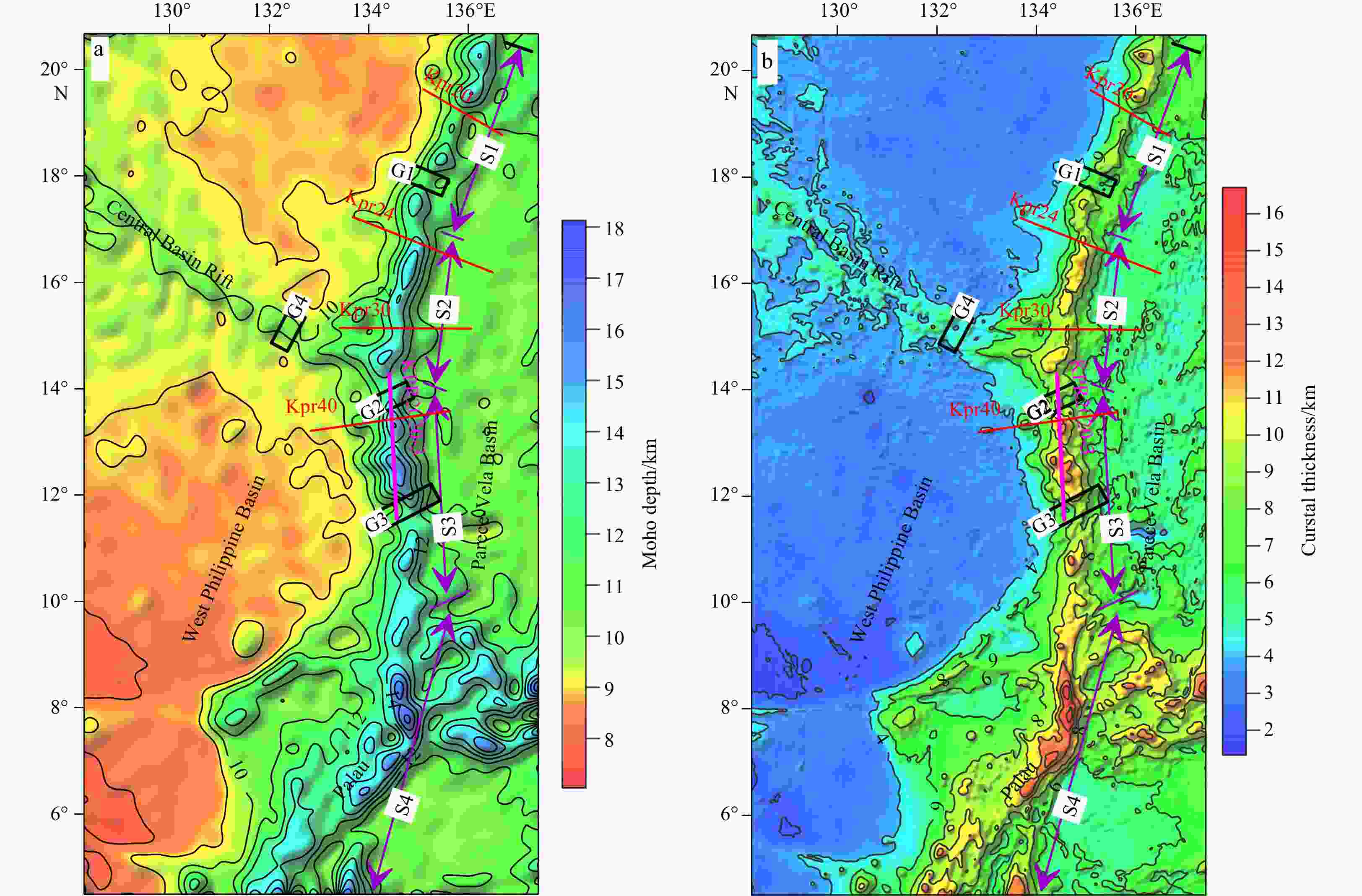
Figure 6. Inversion results of Moho depth and crustal thickness in the study area. a. Moho depth map. b. Crustal thickness map.
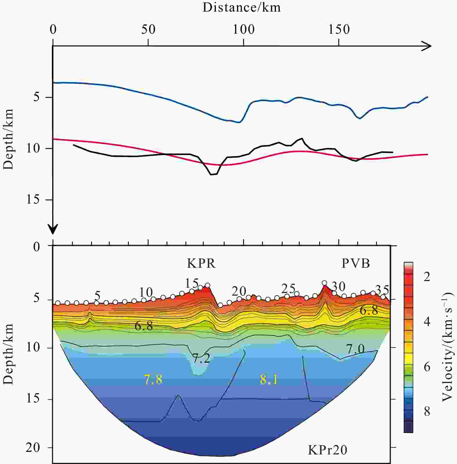
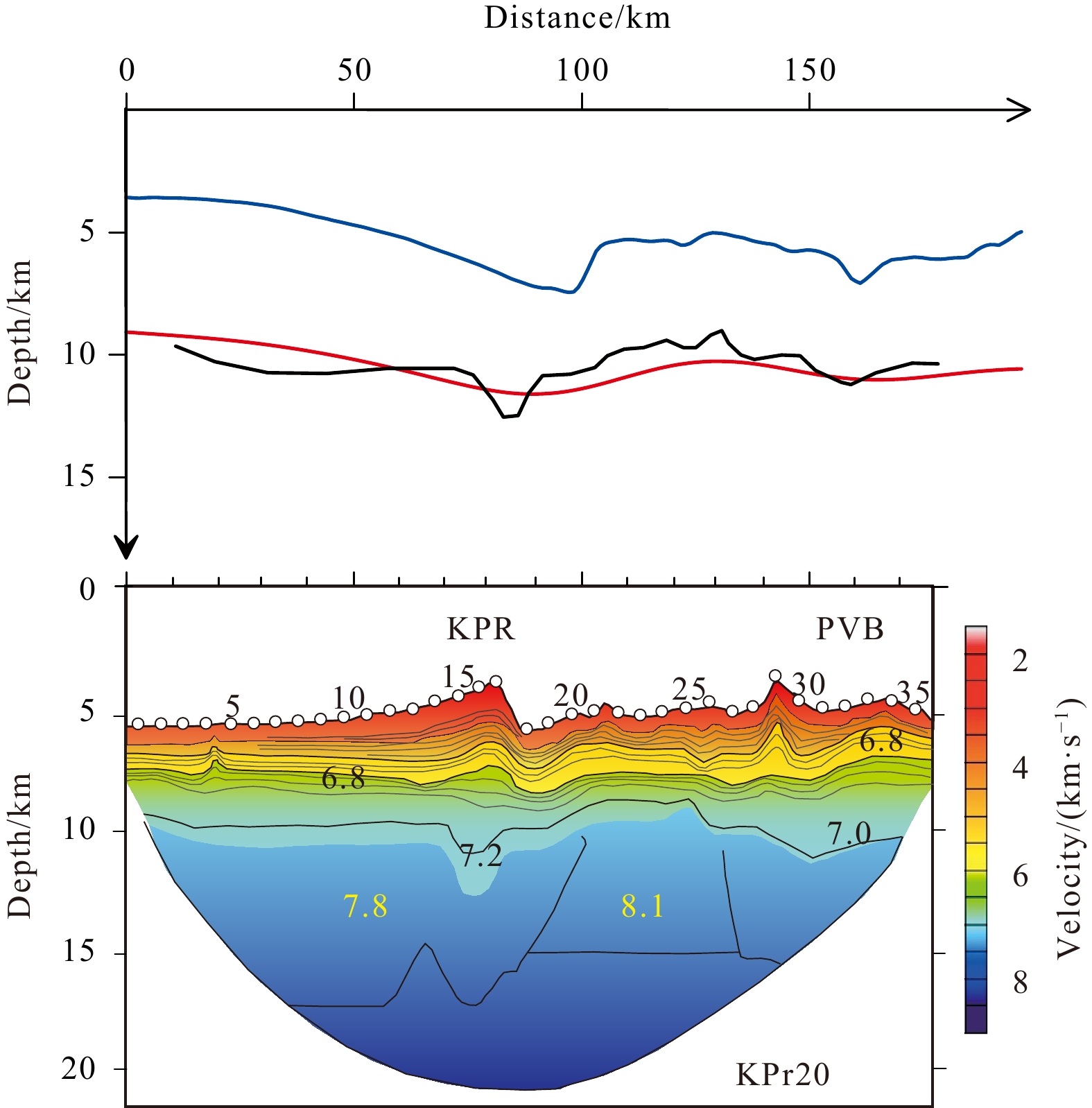
Figure 8. Comparison between the gravity inversion result and Vp models for line KPr20 (Nishizawa et al., 2016). The solid blue line is crustal thickness, the solid red line is Moho depth using gravity inversion, and the solid black line is Moho depth obtained by deep reflection/refraction seismic data. KPR: Kyushu–Palau Ridge; PVB: Parece Vela Basin.
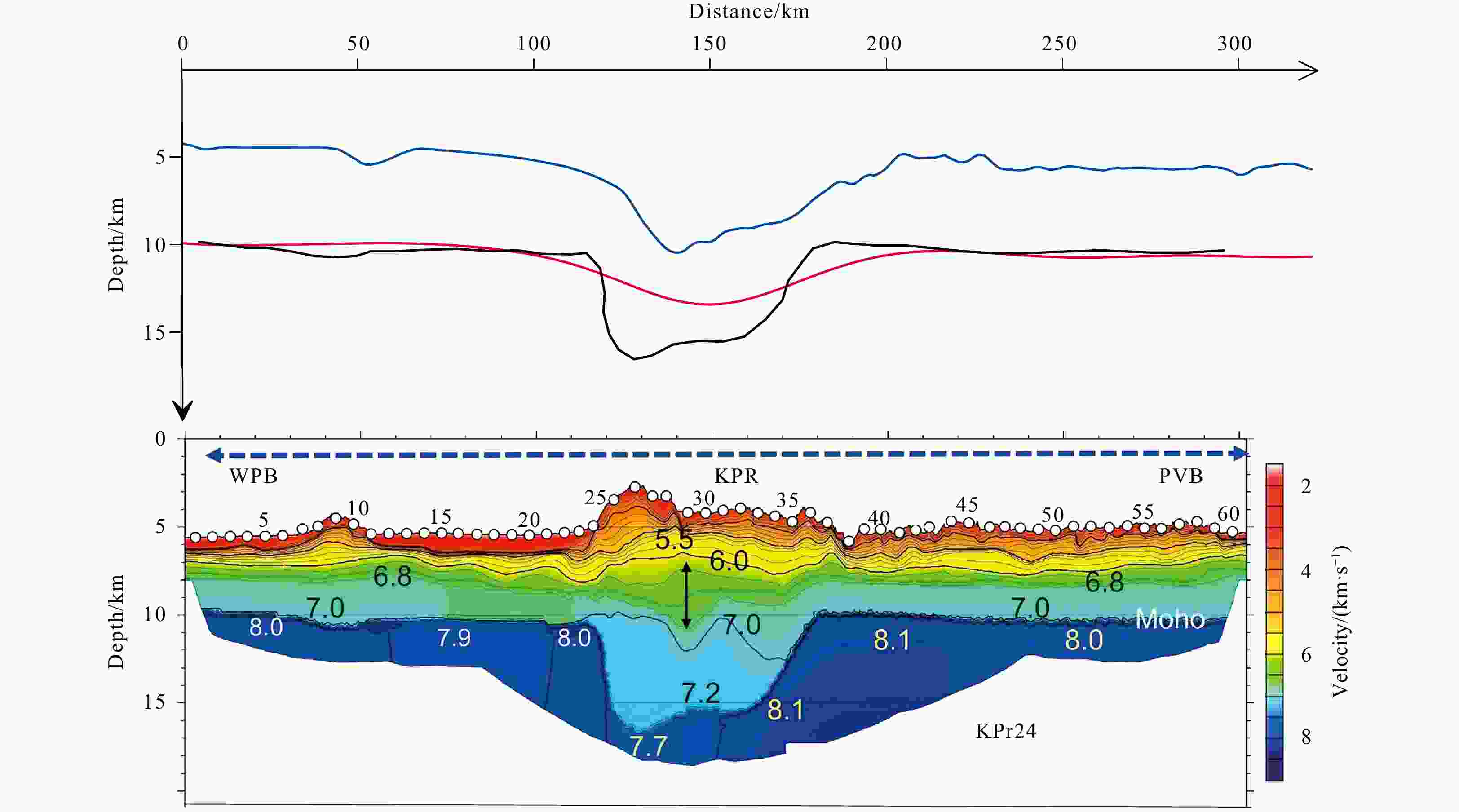
Figure 9. Same as Fig. 7 but for KPr24 (Nishizawa et al., 2016). WPB: West Philippine Basin; KPR: Kyushu–Palau Ridge; PVB: Parece Vela Basin.
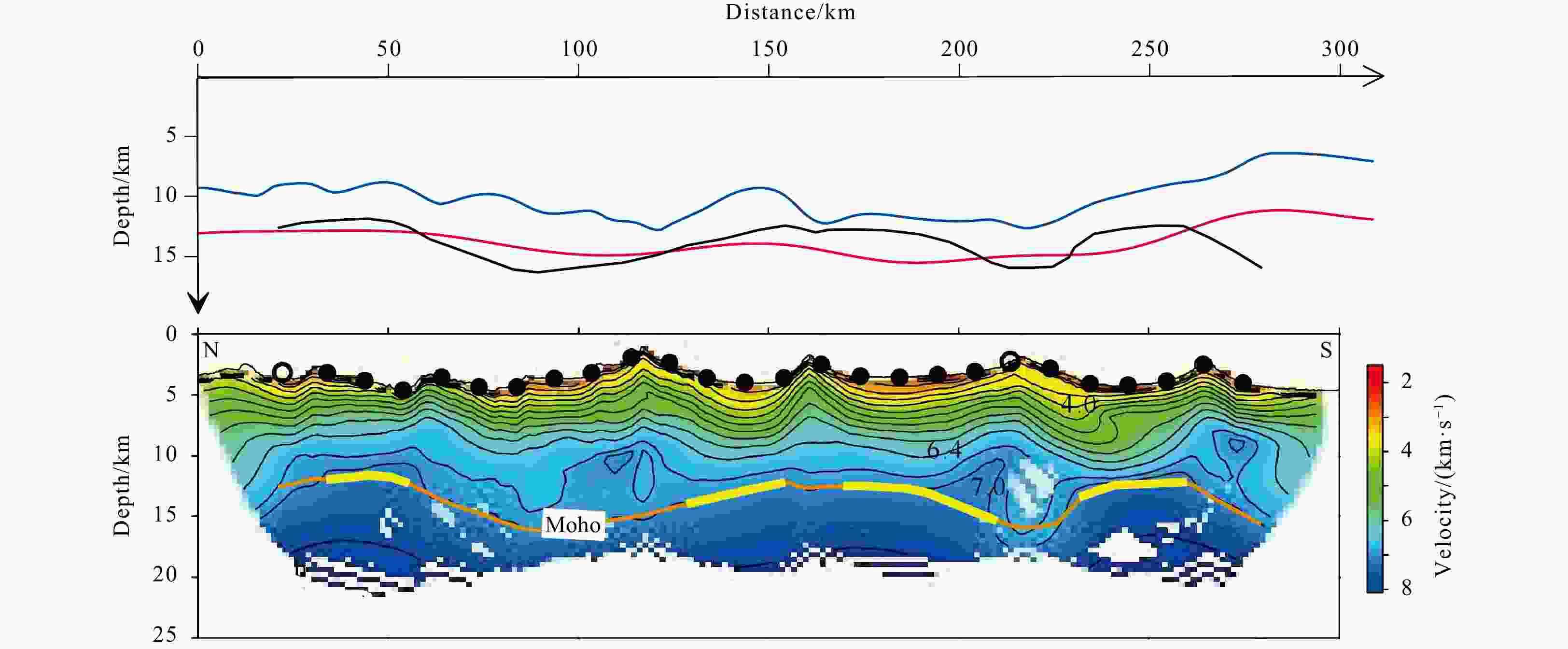
Figure 7. Comparison between the gravity inversion result and Vp models for line KPR2020-3 (Wei et al., 2022). The solid blue line is crustal thickness, the solid red line is Moho depth using gravity inversion, and the solid black line is Moho depth obtained by deep reflection/refraction seismic data.

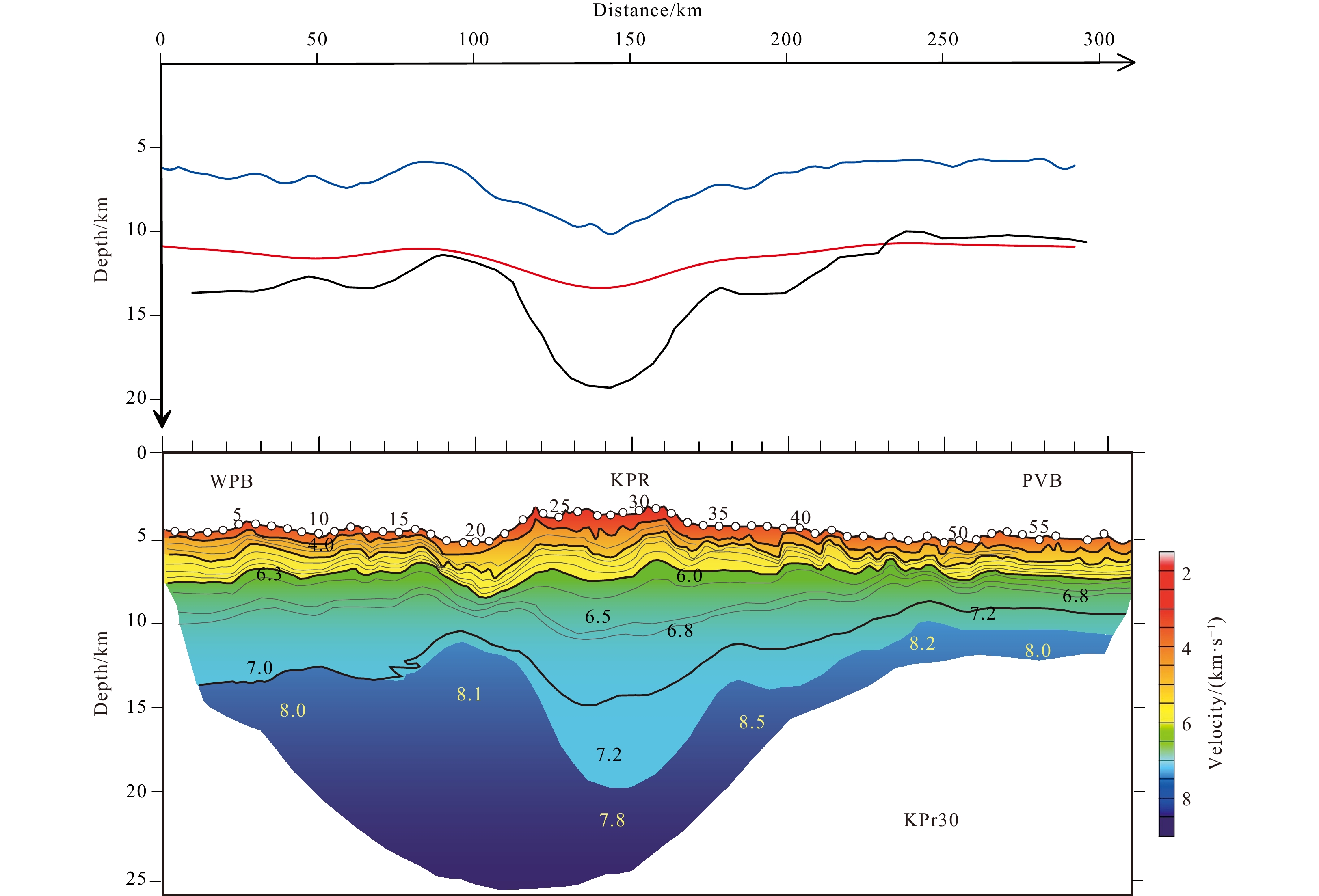
Figure 10. Same as Fig. 7 but for KPr30 (Nishizawa et al., 2016). WPB: West Philippine Basin; KPR: Kyushu–Palau Ridge; PVB: Parece Vela Basin.

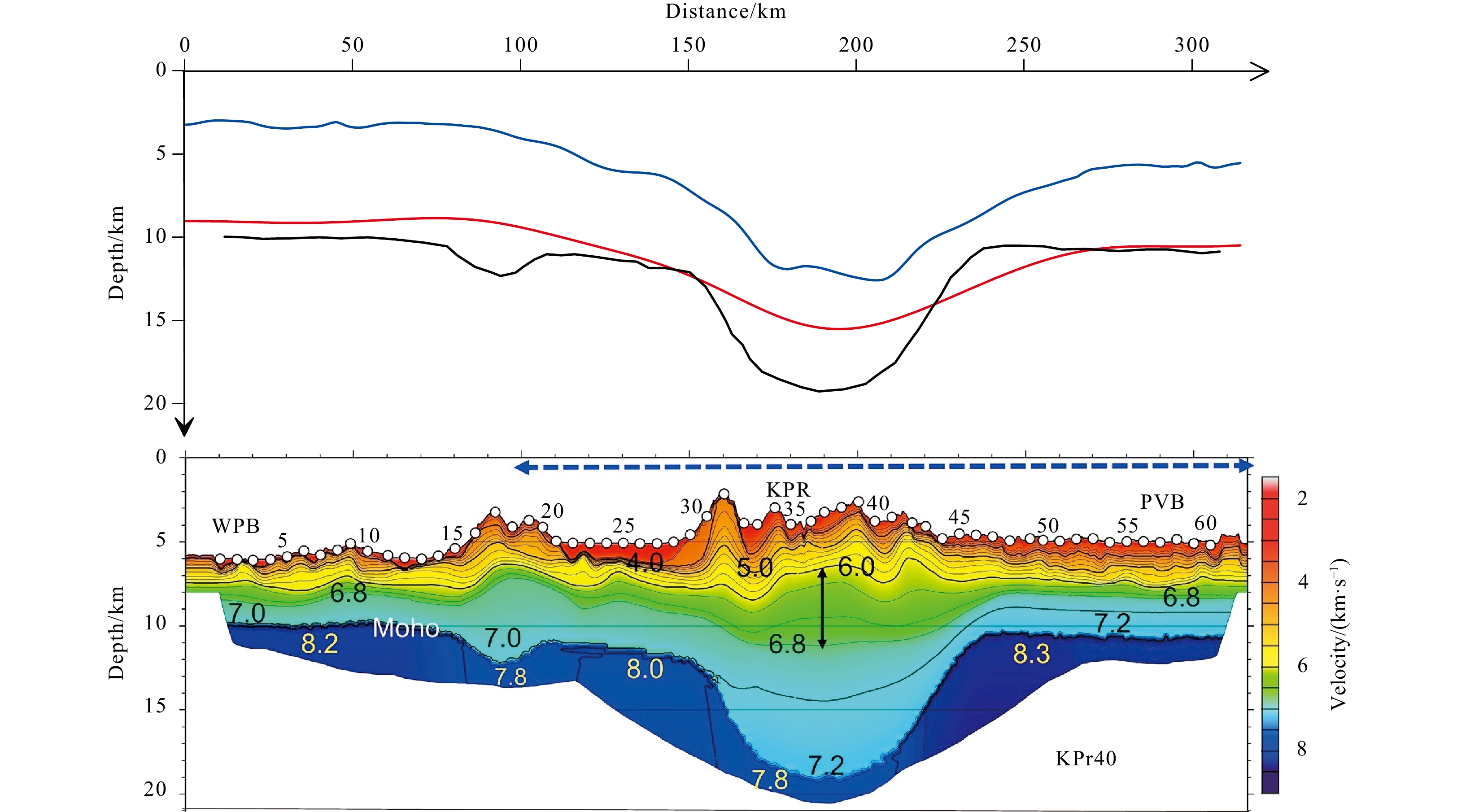
Figure 11. Same as Fig.7 but for line KPr40 (Nishizawa et al., 2016). WPB: West Philippine Basin; KPR: Kyushu–Palau Ridge; PVB: Parece Vela Basin.
Table 1. Features of the faults in the mid-southern KPR and adjacent areas
Fault Trend Length/km Mutually broken relationship Location F1 NW 680 broken by the TF1, TF2 and TF3
located in the north of the CBR, the boundary between the
northern basin and the central riftF2 NW 950 broken by the TF1–TF2 and
misplaces the F4 and F5located in the north of the CBR, the northern
boundary of the central riftF3 NW 1 000 broken by the TF1–TF2, and
misplaces the F4 and F5located in the north of the CBR, the southern
boundary of the central riftF4 NEE 970 misplaces the F8 and F9 located in the north of the Palau Basin and
corresponds to the Mindano Fracture ZoneF5 NEE 645 misplaces the F8 and F9 F6 NE 690 located in the west of the Palau island F7 NE 510 located in the east of the Palau island F8 near-SN 1 560 broken by the FK1, FK2, FK3,
F2, F3 ,F4, F5 and Fslocated in the west of the KPR, the western boundary of the KPR F9 near-SN 1 565 broken by the FK1, FK2, FK3,
F2, F3 ,F4, F5 and Fslocated in the east of the KPR, the eastern boundary of the KPR FN NE 200 located in the north of the eastern section of CBR FS NW 300 misplaces the F8 and F9 located in the south of the eastern section of CBR and
extends through KPR to PVBFK1 NW 325 misplaces the F8 and F9 segmental fault of KPR FK2 near-EW 230 FK3 near-EW 120 TF1 near-SN 430 misplaces the F1, F2 and F3 distributed in the CBR as transform faults TF2 330 TF3 390 TF4 310 TF5 280 TF6 330 TF7 200  下载: 导出CSV
-
Chao Dingbo, Yao Yunsheng, Li Jiancheng, et al. 2002. Interpretaion on the tectonics and characteristics of altimeter-derived gravity anomalies in China South Sea. Geomatics and Information Science of Wuhan University (in Chinese), 27(4): 343–347 Calvert A J. 2011. The seismic structure of island arc crust. In: Brown D, Ryan P D, eds. Arc-Continent Collision Berlin, Heidelberg: Springer, 87–119 Deschamps A, Lallemand S. 2002. The West Philippine Basin: an Eocene to Early Oligocene back arc basin opened between two opposed subduction zones. Journal of Geophysical Research: Solid Earth, 107(B12): 2322 Deschamps A, Okino K, Fujioka K. 2002. Late amagmatic extension along the central and eastern segments of the West Philippine Basin fossil spreading axis. Earth and Planetary Science Letters, 203(1): 277–293, doi: 10.1016/S0012-821X(02)00855-5 Graw J H, Wood W T, Phrampus B J. 2021. Predicting global marine sediment density using the random forest regressor machine learning algorithm. Journal of Geophysical Research: Solid Earth, 126(1): e2020JB020135, doi: 10.1029/2020JB020135 Hall R, Ali J R, Anderson C D, et al. 1995. Origin and motion history of the Philippine Sea Plate. Tectonophysics, 251(1–4): 229–250, doi: 10.1016/0040-1951(95)00038-0 Hilde T W C, Lee C S. 1984. Origin and evolution of the west Philippine Basin: a new interpretation. Tectonophysics, 102(1–4): 85–104, doi: 10.1016/0040-1951(84)90009-X Hou Fanghui, Qin Ke, Lu Kai, et al. 2022. Tectono-sedimentary characteristics and subduction initiation in the middle Kyushu-Palau Ridge and adjacent basins: a comprehensive study of multichannel seismic reflection profiles. Marine Geology & Quaternary Geology (in Chinese), 42(5): 187–198 Hu Zhengan, Zhang Chunguan, Ren Zusong, et al. 2014. Calculation of the Satellite Altimetric bouguer gravity anomaly based on regression analysis. Journal of Yangtze University (Natural Science Edition) (in Chinese), 11(1): 21–23 Ishihara T, Koda K. 2007. Variation of crustal thickness in the Philippine Sea deduced from three-dimensional gravity modeling. Island Arc, 16(3): 322–337, doi: 10.1111/j.1440-1738.2007.00593.x Ishizuka O, Taylor R N, Yuasa M, et al. 2011. Making and breaking an island arc: a new perspective from the Oligocene Kyushu-Palau arc, Philippine Sea. Geochemistry, Geophysics, Geosystems, 12(5): Q05005 Ji Xiaolin, Wang Wanyin, Du Xiangdong, et al. 2019a. Tectonic division by gravity and magnetic anomaly data of salt-bearing basins, south-central section of West Africa. Chinese Journal of Geophysics (in Chinese), 62(4): 1502–1514 Ji Xiaolin, Wang Wanyin, Qiu Zhiyun. 2015. The research to the minimum curvature technique for potential field data separation. Chinese Journal of Geophysics (in Chinese), 58(3): 1042–1058 Ji Xiaolin, Wang Wanyin, Qiu Zhiyun. 2019b. Parameter choose experimental research to the minimum curvature technique potential field data separation method. Progress in Geophysics (in Chinese), 34(4): 1441–1452 Jin Xianglong, Gao Jinyao. 2001. The satellite altimetry gravity field and the geodynamic feature in the West Pacific. Marine Geology & Quaternary Geology (in Chinese), 21(1): 1–6 Kobayashi K. 2004. Origin of the Palau and Yap trench-arc systems. Geophysical Journal International, 157(3): 1303–1315, doi: 10.1111/j.1365-246X.2003.02244.x Lallemand S, Arcay D. 2021. Subduction initiation from the earliest stages to self-sustained subduction: insights from the analysis of 70 Cenozoic sites. Earth-Science Reviews, 221: 103779, doi: 10.1016/j.earscirev.2021.103779 Lei Shoumin. 1984. Calculation of generalized topographic and isostatic gravity corrections. Marine Geology & Quaternary Geology (in Chinese), 4(1): 101–111 Li Changzhen, Li Naisheng, Lin Meihua. 2000. Terrain features of the Philippine sea. Marine Sciences (in Chinese), 24(6): 47–51 Luo Zhicai, Zhong Bo, Zhou Hao, et al. 2022. Progress in determining the Earth’s gravity field model by satellite gravimetry. Geomatics and Information Science of Wuhan University (in Chinese), 47(10): 1713–1727 Ning Jinsheng, Wang Zhengtao, Chao Nengfang. 2016. Research status and progress in international next-generation satellite gravity measurement missions. Geomatics and Information Science of Wuhan University (in Chinese), 41(1): 1–8 Nishizawa A, Kaneda K, Katagiri Y, et al. 2007. Variation in crustal structure along the Kyushu-Palau Ridge at 15–21°N on the Philippine Sea plate based on seismic refraction profiles. Earth, Planets and Space, 59(6): e17–e20 Nishizawa A, Kaneda K, Oikawa M. 2016. Crust and uppermost mantle structure of the Kyushu-Palau Ridge, remnant arc on the Philippine Sea Plate. Earth, Planets and Space, 68(1): 30 Okino K, Fujioka K. 2003. The Central Basin Spreading Center in the Philippine Sea: structure of an extinct spreading center and implications for marginal basin formation. Journal of Geophysical Research: Solid Earth, 108(B1): 2040 Park J O, Hori T, Kaneda Y. 2009. Seismotectonic implications of the Kyushu - Palau Ridge subducting beneath the westernmost Nankai forearc. Earth, Planets and Space, 61(8): 1013–1018 Pasyanos M E, Masters T G, Laske G, et al. 2014. LITHO1.0: an updated crust and lithospheric model of the Earth. Journal of Geophysical Research: Solid Earth, 119(3): 2153–2173, doi: 10.1002/2013JB010626 Sandwell D, Garcia E, Soofi K, et al. 2013. Toward 1-mGal accuracy in global marine gravity from CryoSat-2, Envisat, and Jason-1. The Leading Edge, 32(8): 892–899, doi: 10.1190/tle32080892.1 Sandwell D T, Harper H, Tozer B, et al. 2021. Gravity field recovery from geodetic altimeter missions. Advances in Space Research, 68(2): 1059–1072, doi: 10.1016/j.asr.2019.09.011 Sandwell D T, Müller R D, Smith W H F, et al. 2014. New global marine gravity model from CryoSat-2 and Jason-1 reveals buried tectonic structure. Science, 346(6205): 65–67, doi: 10.1126/science.1258213 Shang Luning, Li Panfeng, Du Runlin, et al. 2021. Structural characteristics of the KPR-CBR triple-junction inferred from gravity and magnetic interpretations, Philippine Sea Plate. China Geology, 4(4): 541–552, doi: 10.31035/cg2021089 Smith W H F, Sandwell D T. 1997. Global sea floor topography from satellite altimetry and ship depth soundings. Science, 277(5334): 1956–1962, doi: 10.1126/science.277.5334.1956 Song Weiyu, Liu Yanan, Hu Bangqi, et al. 2021. Landform classification for the Philippine Sea Based on DEM data. Marine Geology & Quaternary Geology (in Chinese), 41(1): 192–198 Stern R J. 2004. Subduction initiation: spontaneous and induced. Earth and Planetary Science Letters, 226(3–4): 275–292, doi: 10.1016/S0012-821X(04)00498-4 Stern R J, Gerya T. 2018. Subduction initiation in nature and models: a review. Tectonophysics, 746: 173–198, doi: 10.1016/j.tecto.2017.10.014 Straume E O, Gaina C, Medvedev S, et al. 2019. GlobSed: updated total sediment thickness in the world’s oceans. Geochemistry, Geophysics, Geosystems, 20(4): 1756–1772 Taylor B, Goodliffe A M. 2004. The West Philippine Basin and the initiation of subduction, revisited. Geophysical Research Letters, 31(12): L12602 Wang Wanyin, Pan Zuoshu. 1993. Fast solution of forward and inverse problems for gravity field in a dual interface model. Geophysical Prospecting for Petroleum (in Chinese), 32(2): 81–87, 123 Wang Wanyin, Pan Yu, Qiu Zhiyun. 2009. A new edge recognition technology based on the normalized vertical derivative of the total horizontal derivative for potential field data. Applied Geophysics, 6(3): 226–233, doi: 10.1007/s11770-009-0026-x Wang Dingding, Wang Wanyin, Zhu Yingjie, et al. 2021. Extraction methods and application of feature points of edge recognition for potential field. Chinese Journal of Geophysics (in Chinese), 64(4): 1401–1411 Wei Xiaodong, Ding Weiwei, Ruan Aiguo, et al. 2022. Crustal structure and variation along the southern part of the Kyushu-Palau Ridge. Acta Oceanologica Sinica, 41(1): 50–57, doi: 10.1007/s13131-021-1979-8 Wu Shiguo, Fan Jianke, Dong Dongdong. 2013. Discussion on the tectonic division of the Philippine Sea Plate. Chinese Journal of Geology (in Chinese), 48(3): 677–692 Wu J, Suppe J, Lu Renqi, et al. 2016. Philippine Sea and East Asian plate tectonics since 52 Ma constrained by new subducted slab reconstruction methods. Journal of Geophysical Research: Solid Earth, 121(6): 4670–4741, doi: 10.1002/2016JB012923 Yamashita M, Tsuru T, Takahashi N, et al. 2007. Fault configuration produced by initial arc rifting in the Parece Vela Basin as deduced from seismic reflection data. Island Arc, 16(3): 338–347, doi: 10.1111/j.1440-1738.2007.00594.x Yang Huiliang, Wei Jia, Li Panfeng, et al. 2021. Characteristics of the stratigraphic architectures of the shallow sections in deep sea basin on both sides of Kyushu - Palau ridge. Marine Geology & Quaternary Geology (in Chinese), 41(1): 14–21 Zhang Jie, Li Jiabiao, Ding Weiwei. 2012. Reviews of the study on crustal structure and evolution of the Kyushu-Palau ridge. Advances in Marine Science (in Chinese), 30(4): 595–607 Zhang Feifei, Wang Hao, Zhang Yimi, et al. 2023. Accuracy analysis of satellite altimetry gravity data in the Western Pacific Area. Geomatics and Information Science of Wuhan University (in Chinese), ). https://doi.org/10.13203/j.whugis20220429 [2023/-05/-26] Zhang Minghua, Zhang Jiaqiang. 2005. Resolution of modern satellite altimetric gravity anomaly and its application to marine geological survey. Geophysical & Geochemical Exploration (in Chinese), 29(4): 295–298,303 Zhang Chunguan, Zhang Minghua, An Yulin. 2007. The negative correlation correction between gravity anomaly and topography of Tibetan Plateau. Geophysical & Geochemical Exploration (in Chinese), 31(3): 236–238 -


 点击查看大图

计量
- 文章访问数: 195
- HTML全文浏览量: 88
- PDF下载量: 10
- 被引次数: 0

