

Detection and Analysis of Spartina alterniflora in Chongming East Beach Using Sentinel-2 Imagery and Image Texture Features
-
Abstract: Spartina alterniflora Loisel is now listed among the world’s 100 most dangerous invasive species, severely affecting the ecological balance of coastal wetlands. Remote sensing technologies based on deep learning enable large-scale monitoring of Spartina alterniflora, but they require large datasets and have poor interpretability. A new method is proposed to detect Spartina alterniflora Loisel from Sentinel-2 imagery. Firstly, to get the high canopy cover and dense community characteristics of Spartina alterniflora Loisel, multi-dimensional shallow features are extracted from the imagery. Secondly, to detect different objects from satellite imagery, index features are extracted, and the statistical features of the gray-level co-occurrence matrix (GLCM) are derived using Principal Component Analysis - Gray-Level Co-Occurrence Matrix (PCA-GLCM). Then, ensemble learning methods, including Random Forest (RF), eXtreme Gradient Boosting (XGBoost), and Light Gradient Boosting Machine (LightGBM) models, are employed for image classification. Meanwhile, Recursive Feature Elimination with Cross-Validation (RFECV) is used to select the best feature subset. Finally, to enhance the interpretability of the models, the best features are utilized to classify multi-temporal images and SHapley Additive exPlanations (SHAP) is combined with these classifications to explain the model prediction process. The method is validated by using Sentinel-2 imageries and previous observations of Spartina alterniflora Loisel in Chongming Island, it is found that the model combining image texture features such as GLCM covariance can significantly improve the detection accuracy of Spartina alterniflora by about 8% compared with the model without image texture features. Through multiple model comparisons and feature selection via RFECV, the selected model and eight features demonstrated good classification accuracy when applied to data from different time periods, proving that feature reduction can effectively enhance model generalization. Additionally, visualizing model decisions using SHAP revealed that the image texture feature component_1_GLCMVariance is particularly important for identifying each land cover type.
-
Key words:
- texture features /
- RFECV /
- SHAP /
- Sentinel 2 time-series imagery /
- Multi-model comparison
-
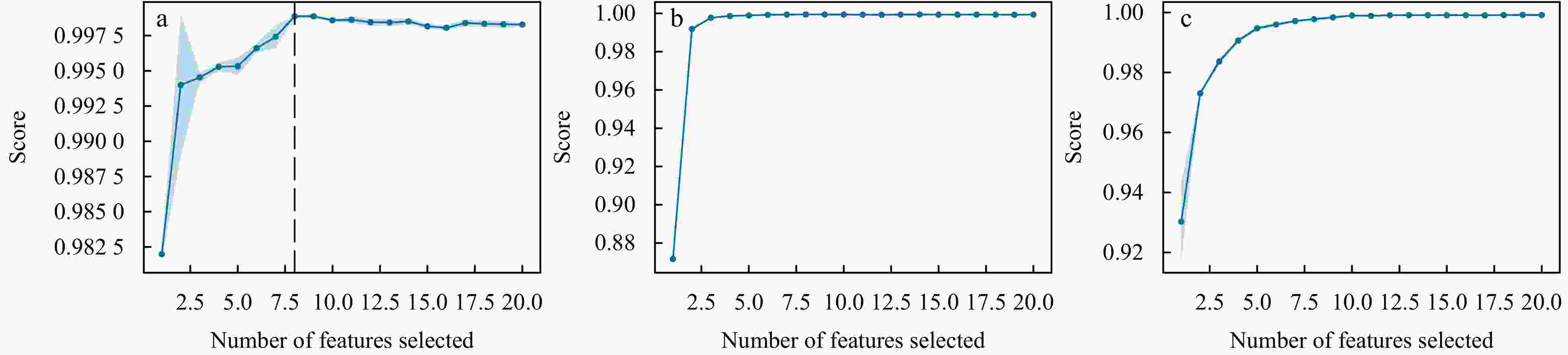
Figure 3. The curve of cross-validated scores as the number of features changes, based on RFECV feature selection applied to the original 20-dimensional features. A line chart of (a) RF+RFECV, a line chart of (b) LightGBM+RFECV and a line chart of (c) XGBoost+RFECV are showed on the top.
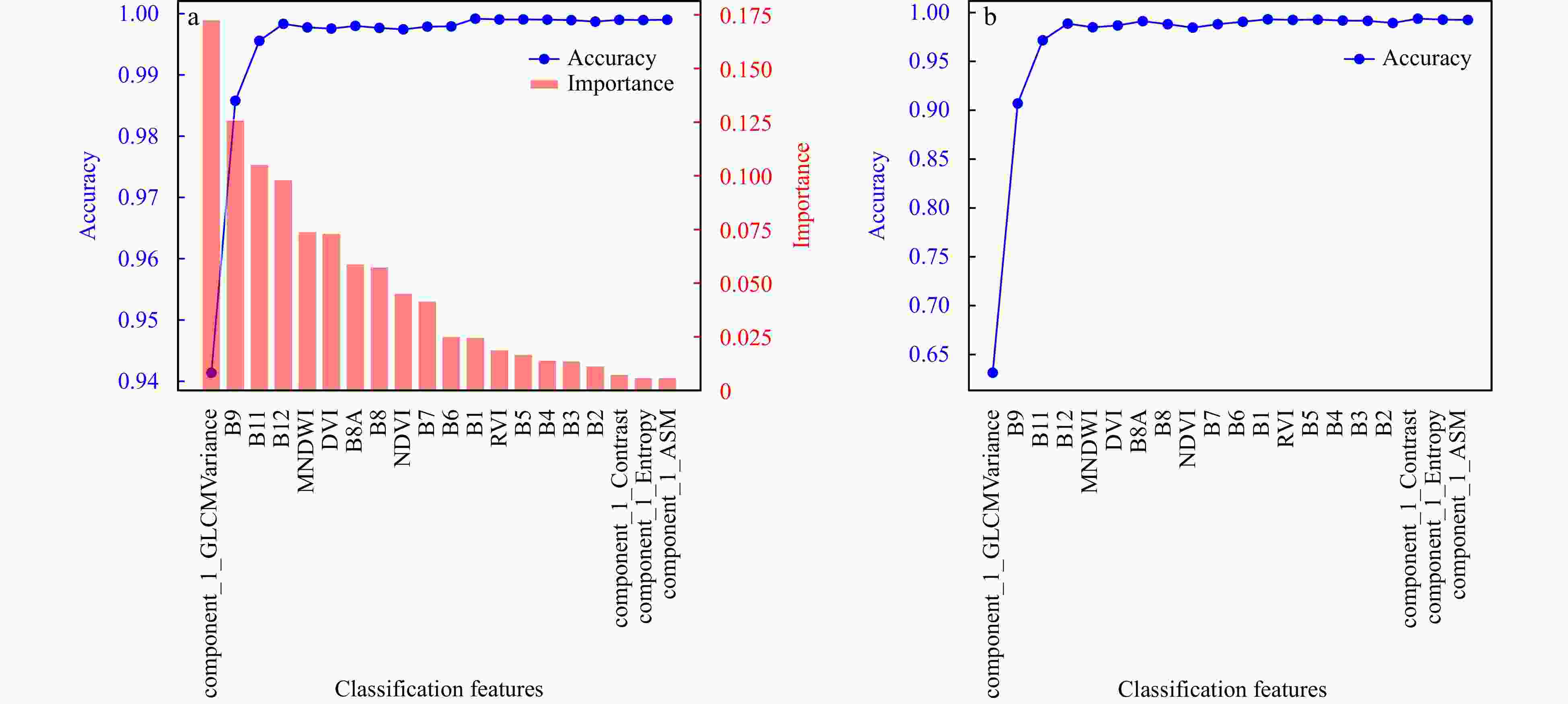
Figure 4. Model accuracy with different features. (a) The feature importance of the RF model and the overall model accuracy as the feature combination changes. (b) The variation of Spartina alterniflora classification accuracy with different feature combinations.
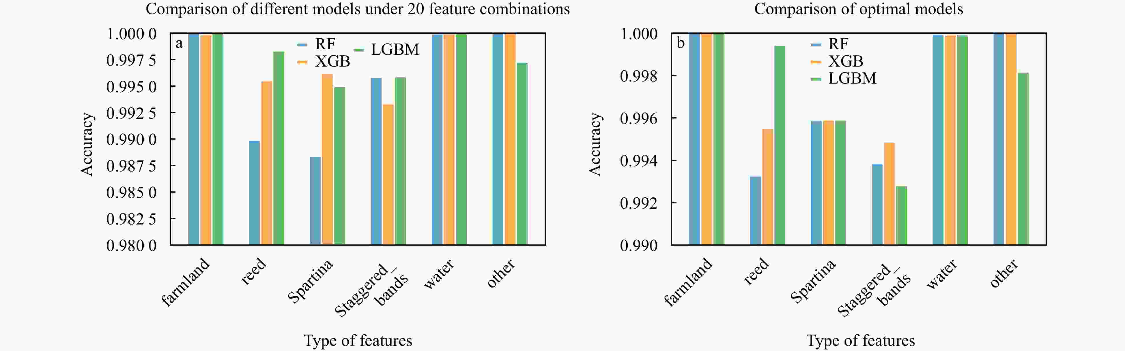
Figure 5. Accuracy of various land covers under different models. (a) Comparison of different models under 20 feature combinations. (b) Comparison of optimal models.
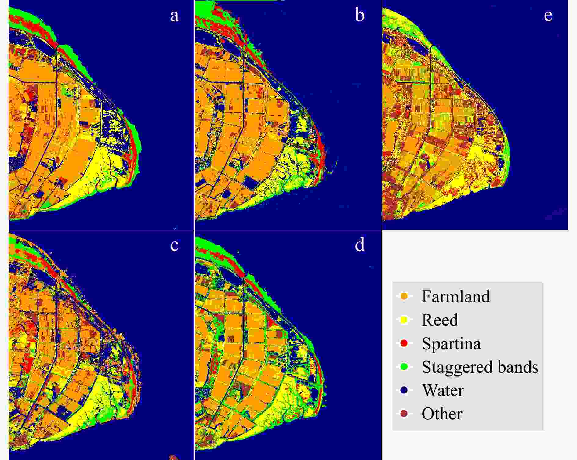
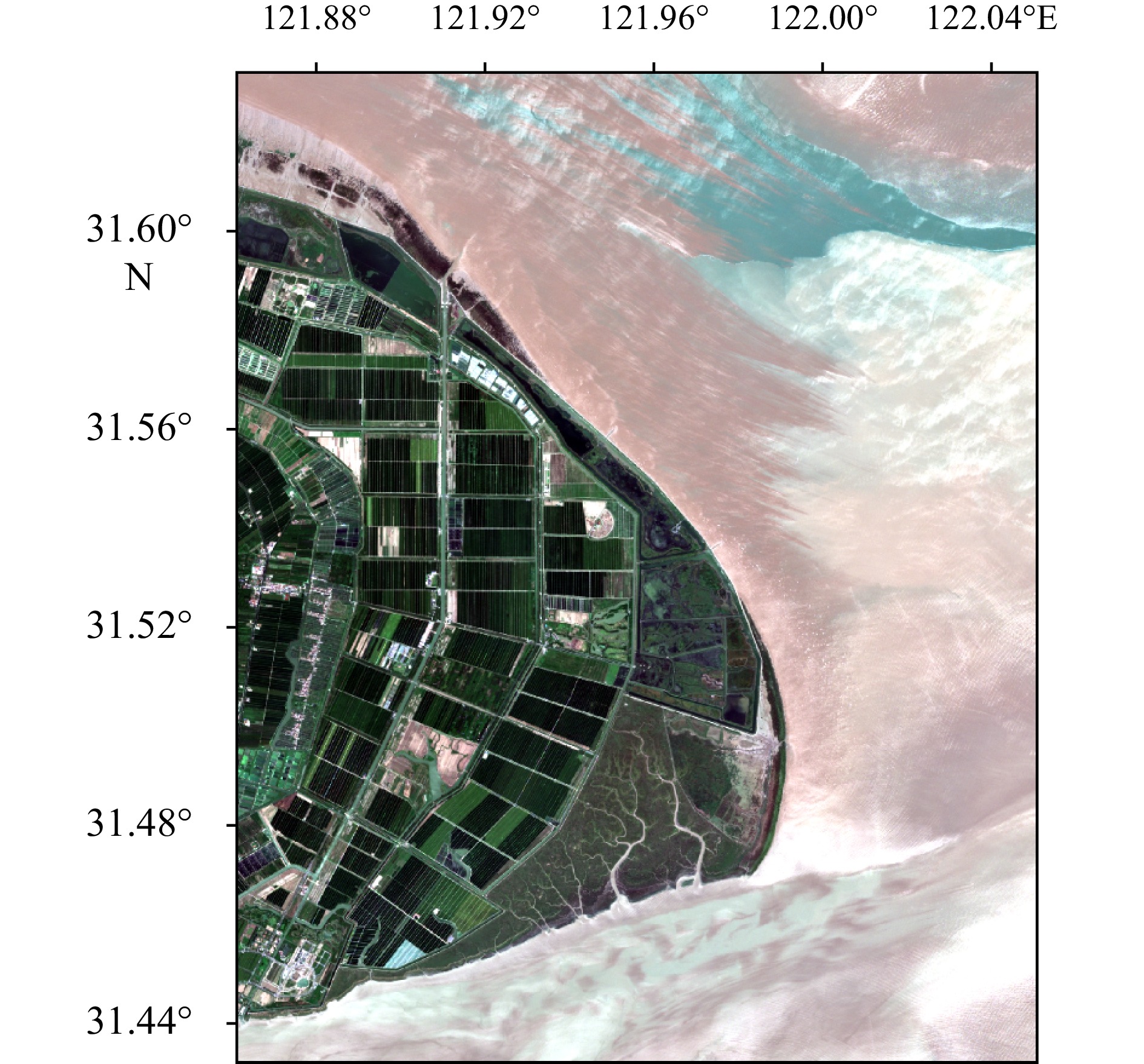
Figure 6. The selected four Sentinel-2 images from (a) January 21, 2020, (b) April 23, 2020, (c) June 2, 2020, and (d) September 5, 2020, for land cover classification and Spartina alterniflora detection. Figure 6e represents the land cover interpretation results.
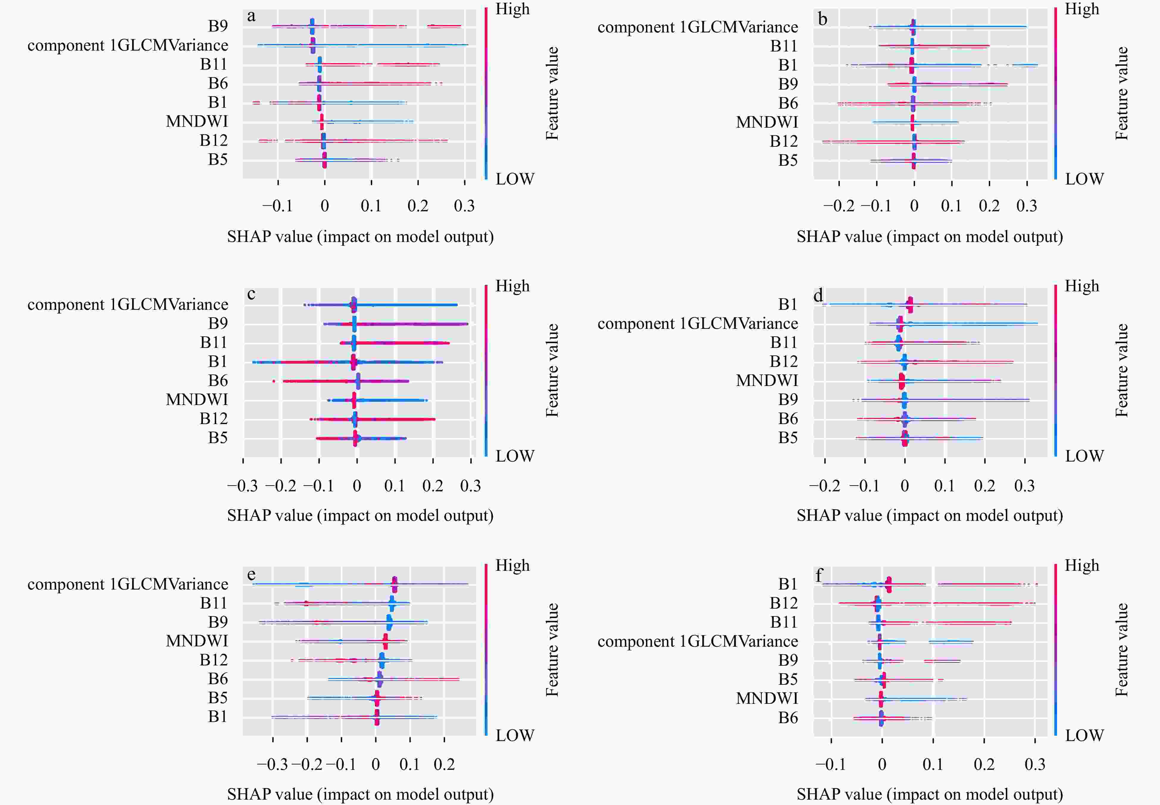
Figure 7. The SHAP summary plot for each land cover type. (a) SHAP summary plot for farmland classification, (b) SHAP summary plot for breed classification, (c) SHAP summary plot for Spartina alterniflora classification, (d) SHAP summary plot for Staggered bands classification, (e) SHAP summary plot for water classification, (f) SHAP summary plot for other classification.
Table 1. Spectral bands of Sentinel-2 MSI L2A (Segarra et al., 2020).
Bands Wavelength (nm) Resolution (m) B1-Coastal aerosol 433-453 60 B2-Blue 458-523 10 B3-Green 543-578 10 B4-Red 650-680 10 B5-Vegetation red edge 698-713 20 B6-Vegetation red edge 733-748 20 B7-Vegetation red edge 773-793 20 B8-NIR 785-900 10 B8A-Narrow NIR 855-875 20 B9-Water vapour 935-955 60 B11-SWIR 1565 -1655 20 B12-SWIR 2100 -2280 20  下载: 导出CSV
Table 2. Training and validation data of different land cover types.
Types Label Training
samplesValidation
samplesfarmland 1 22 9 reed 2 19 8 Spartina alterniflora 3 20 9 Staggered-bands 4 17 7 water 5 23 10 other (Bare ground,
building,Scirpus)6 21 9
下载: 导出CSV
Table 3. The classification accuracy of wetland features in the experimental area using different algorithms.
type RF_20 RF_8 XGB_20 XGB_19 LGBM_20 LGBM_8 PA (%) UA (%) PA UA PA UA PA UA PA UA PA UA farmland 99.97 100 99.95 100 99.97 99.98 99.95 100 99.95 99.98 100 100 reed 99.49 98.99 99.77 99.33 99.77 99.55 99.71 99.54 99.72 99.83 99.72 99.94 Spartina 99.37 98.84 99.50 99.59 99.59 99.62 99.71 99.59 99.75 99.50 99.65 99.59 staggered 98.26 99.58 99.23 99.38 99.23 99.33 99.17 99.48 99.13 99.59 99.18 99.28 water 100 99.99 99.99 99.99 99.99 99.99 99.99 99.99 100 99.99 100 99.99 other 100 100 100 100 100 100 100 100 100 99.73 100 99.81 OA 99.91 99.94 99.95 99.95 99.95 99.95 1 Spartina stands for Spartina alterniflora; staggered stands for Spartina alterniflora-reed mixed staggered zone; type stands for land cover type.
下载: 导出CSV
-
Chen Xuewen, Jeong J C. 2007. Enhanced recursive feature elimination. In: Sixth International Conference on Machine Learning and Applications (ICMLA 2007). Cincinnati: IEEE, 429–435 Costanza R, d’Arge R, De Groot R, et al. 1997. The value of the world’s ecosystem services and natural capital. Nature, 387(6630): 253–260, doi: 10.1038/387253a0 Cui Bin’ge, Wu Jing, Li Xinhui, et al. 2023. Combination of deep learning and vegetation index for coastal wetland mapping using GF-2 remote sensing images. National Remote Sensing Bulletin (in Chinese), 27(6): 1376–1386, doi: 10.11834/jrs.20221658 Ding Wenhui, Jiang Junyan, Li Xiuzhen, et al. 2015. Spatial distribution of species and influencing factors across salt marsh in southern Chongming Dongtan. Chinese Journal of Plant Ecology (in Chinese), 39(7): 704–716, doi: 10.17521/cjpe.2015.0067 Feng Kaidong, Mao Dehua, Qiu Zhiqiang, et al. 2022. Can time-series sentinel images be used to properly identify wetland plant communities?. GIScience & Remote Sensing, 59(1): 2202–2216 Gao Zhiqiang, Ai Jinquan, Gao Wei, et al. 2016. Integrating pan-sharpening and classifier ensemble techniques to map an invasive plant (Spartina alterniflora) in an estuarine wetland using Landsat 8 imagery. Journal of Applied Remote Sensing, 10(2): 026001, doi: 10.1117/1.JRS.10.026001 Grinsztajn L, Oyallon E, Varoquaux G. 2022. Why do tree-based models still outperform deep learning on typical tabular data?. In: Proceedings of the 36th International Conference on Neural Information Processing Systems. New Orleans: Curran Associates Inc. , 507–520 Hall-Beyer M. 2017. Practical guidelines for choosing GLCM textures to use in landscape classification tasks over a range of moderate spatial scales. International Journal of Remote Sensing, 38(5): 1312–1338, doi: 10.1080/01431161.2016.1278314 Jiang Lifen, Luo Yiqi, Chen Jiakuan, et al. 2009. Ecophysiological characteristics of invasive Spartina alterniflora and native species in salt marshes of Yangtze River estuary, China. Estuarine, Coastal and Shelf Science, 81 (1): 74–82 Lan Zeying, Liu Yang. 2018. Study on multi-scale window determination for GLCM texture description in high-resolution remote sensing image geo-analysis supported by GIS and domain knowledge. ISPRS International Journal of Geo-Information, 7(5): 175, doi: 10.3390/ijgi7050175 Lundberg S M, Erion G, Chen H, et al. 2020. From local explanations to global understanding with explainable AI for trees. Nature Machine Intelligence, 2(1): 56–67, doi: 10.1038/s42256-019-0138-9 Lundberg S M, Lee S I. 2017. A unified approach to interpreting model predictions. In: Proceedings of the 31st International Conference on Neural Information Processing Systems. Long Beach: Curran Associates Inc. , 4768–4777 Mahdavi S, Salehi B, Granger J, et al. 2018. Remote sensing for wetland classification: A comprehensive review. GIScience & Remote Sensing, 55(5): 623–658 Meng Xiangzhen, Liu Dan, Huang Ke, et al. 2021. Extraction method of Spartina alterniflora based on vegetation phenology characteristics: a case study of wetlands in the Changjiang River Delta. Marine Science Bulletin (in Chinese), 40(5): 591–600 Ouyang Zutao, Gao Yu, Xie Xiao, et al. 2013. Spectral discrimination of the invasive plant Spartina alterniflora at multiple phenological stages in a saltmarsh wetland. PLoS ONE, 8(6): e67315, doi: 10.1371/journal.pone.0067315 Ren Guangbo, Liu Yanfen, Ma Yi, et al. 2014. Spartina alterniflora monitoring and change analysis in Yellow River Delta by remote sensing technology. Acta Laser Biology Sinica (in Chinese), 23(6): 596–603 Segarra J, Buchaillot M L, Araus J L, et al. 2020. Remote sensing for precision agriculture: Sentinel-2 improved features and applications. Agronomy, 10(5): 641, doi: 10.3390/agronomy10050641 Shao Chunchen, Yang Gang, Sun Weiwei, et al. 2024. Construction method of a Spartina alterniflora index based on hyperspectral satellite images. National Remote Sensing Bulletin (in Chinese), 28(3): 635–648, doi: 10.11834/jrs.20242621 Shu Minyan, Tian Bo, Ding Lixia, et al. 2019. Spectral analysis of an intertidal saltmarsh in the Yangtze Estuary. Journal of Zhejiang A& F University (in Chinese), 36(1): 107–117 Tang Chendong. 2016. Ecological control of Spartina alterniflora and improvement of birds habitats in Chongming Dongtan wetland, Shanghai. Wetland Science & Management (in Chinese), 12(3): 4–8 Xu Wei, Zhou Yunxuan, Shen Fang, et al. 2018. Recognition and extraction of phragmites australis salt marsh vegetation in Chongming tidal flat from Sentinel-1A SAR data. Journal of Jilin University (Earth Science Edition) (in Chinese), 48(4): 1192–1200 Yao Hongyan, Liu Pudong, Shi Runhe, et al. 2017. Extracting the transitional zone of Spartina alterniflora and Phragmites australis in the wetland using high-resolution remotely sensed images. Journal of Geo-Information Science (in Chinese), 19(10): 1375–1381 Zhang Xin, Cui Jintian, Wang Weisheng, et al. 2017. A study for texture feature extraction of high-resolution satellite images based on a direction measure and gray level co-occurrence matrix fusion algorithm. Sensors, 17(7): 1474, doi: 10.3390/s17071474 Zhang Siqing, Liu Yi, Liu Yiran, et al. 2021. Cellular automata simulation of population expansion dynamics of Spartina alterniflora in the Yellow River Delta. Journal of Beijing Normal University (Natural Science) (in Chinese), 57(1): 121–127 Zhang Xi, Xiao Xiangming, Qiu Shiyun, et al. 2022. Quantifying latitudinal variation in land surface phenology of Spartina alterniflora saltmarshes across coastal wetlands in China by Landsat 7/8 and Sentinel-2 images. Remote Sensing of Environment, 269: 112810, doi: 10.1016/j.rse.2021.112810 Zhu Yuling, Wang Jianbu, Wang Andong, et al. 2019. Remote-sensed monitoring of Spartina alterniflora using deep convolutional neural network method with fusion of shallow features. Marine Sciences (in Chinese), 43(7): 12–22 -


 点击查看大图
计量
- 文章访问数: 59
- HTML全文浏览量: 26
- 被引次数: 0

