Latest Articles
Articles in press have been peer-reviewed and accepted, which are not yet assigned to volumes/issues, but are citable by Digital Object Identifier (DOI).
Display Method:
, Available online , doi: 10.1007/s13131-024-2397-5
Abstract:
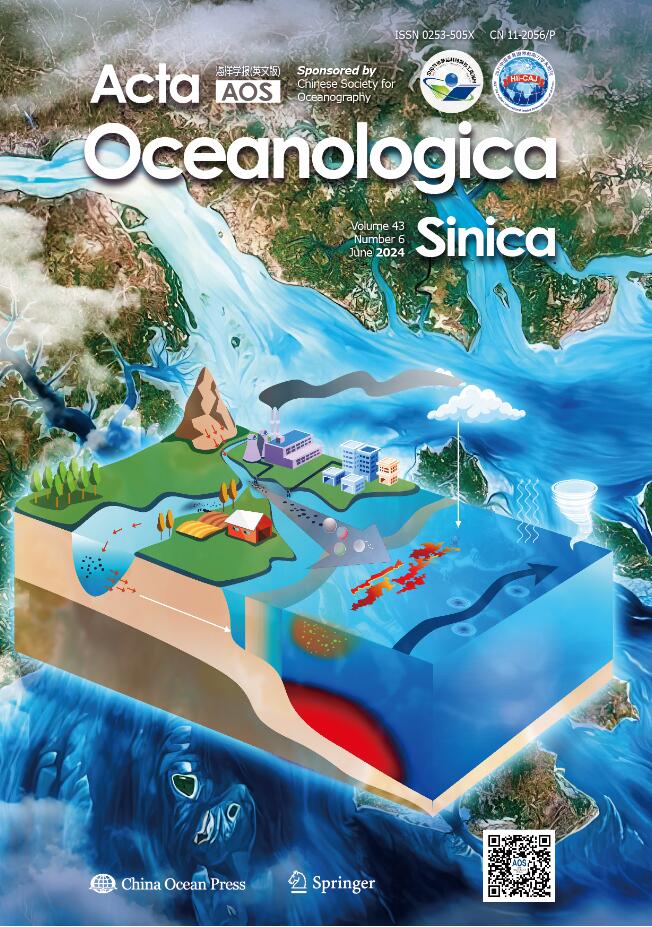
Ridges are common features found on continental shelves and understanding their formation processes is crucial for sedimentology, stratigraphy, and geological engineering. This study investigates the development of ridges on the broad shelf of the East China Sea (ECS) using a core (DH03) and associated seismic profile. Lithology analysis of the core revealed a 50 m thick shallow sandy sequence which consisted mainly of silty fine sands with intercalations of mud beds composed of sand-mud couplets. Benthic foraminifera examination indicated the offshore species were dominant. The seismic profile indicated that the ridges were separated from the older delta layers due to a boundary formed by river erosion during the last glacial maximum. Radiocarbon dating of the sandy sequence revealed an irregular chronological sequence, with most age ranges falling within the past 3 ka. Based on the chronological data from DH03 and other cores, we propose that the ridges, which were formed during the early Holocene transgression, have been active on a shelf scale in the recent 3–2 ka. Synthetic analysis of the shelf-scale ridge formation processes indicates that the sea-level fluctuations during the mid-late Holocene sea-level highstand triggered the ridge activities. A center for ridge activity developed in the southern shelf, facilitated by thicker ridge deposits in the paleo-Changjiang River Estuary and stronger currents (tidal currents and possibly internal waves) induced by the remaining funnel-shaped estuary topography. Based on these findings, we propose a conceptual model for ridge development, which includes a ridge formation stage during the early Holocene transgression and a ridge activation stage during the mid-late Holocene sea-level highstand.
Ridges are common features found on continental shelves and understanding their formation processes is crucial for sedimentology, stratigraphy, and geological engineering. This study investigates the development of ridges on the broad shelf of the East China Sea (ECS) using a core (DH03) and associated seismic profile. Lithology analysis of the core revealed a 50 m thick shallow sandy sequence which consisted mainly of silty fine sands with intercalations of mud beds composed of sand-mud couplets. Benthic foraminifera examination indicated the offshore species were dominant. The seismic profile indicated that the ridges were separated from the older delta layers due to a boundary formed by river erosion during the last glacial maximum. Radiocarbon dating of the sandy sequence revealed an irregular chronological sequence, with most age ranges falling within the past 3 ka. Based on the chronological data from DH03 and other cores, we propose that the ridges, which were formed during the early Holocene transgression, have been active on a shelf scale in the recent 3–2 ka. Synthetic analysis of the shelf-scale ridge formation processes indicates that the sea-level fluctuations during the mid-late Holocene sea-level highstand triggered the ridge activities. A center for ridge activity developed in the southern shelf, facilitated by thicker ridge deposits in the paleo-Changjiang River Estuary and stronger currents (tidal currents and possibly internal waves) induced by the remaining funnel-shaped estuary topography. Based on these findings, we propose a conceptual model for ridge development, which includes a ridge formation stage during the early Holocene transgression and a ridge activation stage during the mid-late Holocene sea-level highstand.


, Available online , doi: 10.1007/s13131-024-2361-4
Abstract:
Shipboard radiosonde soundings are important for detecting and quantifying the multiscale variability of atmosphere-ocean interactions associated with mass exchanges. This study evaluated the accuracies of shipboard global positioning system (GPS) soundings in the eastern tropical Indian Ocean and South China Sea through a simultaneous balloon-borne inter-comparison of different radiosonde types. Our results indicate that the temperature and relative humidity (RH) measurements of GPS-TK radiosonde (used at most stations before 2012) have larger biases than those of CF-06-A radiosonde (widely used in current observation) when compared to reference data from Vaisala RS92-SGP radiosonde, with a warm bias of 5℃ and dry bias of 10% during daytimes, and a cooling bias of –0.8℃ and a moist bias of 6% during nighttime. These systematic biases are primarily attributed to the radiation effects and altitude deviation. An empirical correction algorithm was developed to retrieve the atmospheric temperature and RH profiles. The corrected profiles agree well with that of RS92-SGP, except for uncertainties of CF-06-A in the stratosphere. These correction algorithms were applied to the GPS-TK historical sounding records, reducing biases in the corrected temperature and RH profiles when compared to radio occultation data. The correction of GPS-TK historical records illustrated an improvement in capturing the marine atmospheric structure, with more accurate atmospheric boundary layer height, convective available potential energy, and convective inhibition in the tropical ocean. This study contributes significantly to improving the quality of GPS radiosonde soundings and promotes the sharing of observation in the eastern tropical Indian Ocean and South China Sea.
Shipboard radiosonde soundings are important for detecting and quantifying the multiscale variability of atmosphere-ocean interactions associated with mass exchanges. This study evaluated the accuracies of shipboard global positioning system (GPS) soundings in the eastern tropical Indian Ocean and South China Sea through a simultaneous balloon-borne inter-comparison of different radiosonde types. Our results indicate that the temperature and relative humidity (RH) measurements of GPS-TK radiosonde (used at most stations before 2012) have larger biases than those of CF-06-A radiosonde (widely used in current observation) when compared to reference data from Vaisala RS92-SGP radiosonde, with a warm bias of 5℃ and dry bias of 10% during daytimes, and a cooling bias of –0.8℃ and a moist bias of 6% during nighttime. These systematic biases are primarily attributed to the radiation effects and altitude deviation. An empirical correction algorithm was developed to retrieve the atmospheric temperature and RH profiles. The corrected profiles agree well with that of RS92-SGP, except for uncertainties of CF-06-A in the stratosphere. These correction algorithms were applied to the GPS-TK historical sounding records, reducing biases in the corrected temperature and RH profiles when compared to radio occultation data. The correction of GPS-TK historical records illustrated an improvement in capturing the marine atmospheric structure, with more accurate atmospheric boundary layer height, convective available potential energy, and convective inhibition in the tropical ocean. This study contributes significantly to improving the quality of GPS radiosonde soundings and promotes the sharing of observation in the eastern tropical Indian Ocean and South China Sea.


, Available online , doi: 10.1007/s13131-024-2357-0
Abstract:
The frontogenetic processes of a submesoscale cold filament driven by the thermal convection turbulence are studied by a non-hydrostatic large eddy simulation. The results show that the periodic changes in the direction of the cross-filament secondary circulations are induced by the inertial oscillation. The change in the direction of the secondary circulations induces the enhancement and reduction of the horizontal temperature gradient during the former and later inertial period, which indicates that the frontogenetical processes of the cold filament include both of frontogenesis and frontolysis. The structure of the cold filament may be broken and restored by frontogenesis and frontolysis, respectively. The magnitude of the down-filament currents has a periodic variation, while its direction is unchanged with time. The coupling effect of the turbulent mixing and the frontogenesis and frontolysis gradually weakens the temperature gradient of the cold filament with time, which reduces frontogenetical intensity and enlarges the width of cold filament.
The frontogenetic processes of a submesoscale cold filament driven by the thermal convection turbulence are studied by a non-hydrostatic large eddy simulation. The results show that the periodic changes in the direction of the cross-filament secondary circulations are induced by the inertial oscillation. The change in the direction of the secondary circulations induces the enhancement and reduction of the horizontal temperature gradient during the former and later inertial period, which indicates that the frontogenetical processes of the cold filament include both of frontogenesis and frontolysis. The structure of the cold filament may be broken and restored by frontogenesis and frontolysis, respectively. The magnitude of the down-filament currents has a periodic variation, while its direction is unchanged with time. The coupling effect of the turbulent mixing and the frontogenesis and frontolysis gradually weakens the temperature gradient of the cold filament with time, which reduces frontogenetical intensity and enlarges the width of cold filament.


, Available online , doi: 10.1007/s13131-024-2352-5
Abstract:
The tide plays a pivotal role in the ocean, affecting the global ocean circulation and supplying the bulk of the energy for the global meridional overturning circulation. To further investigate internal tides and their impacts on circulation, it is imperative to incorporate tidal forcing into the eddy-resolving global ocean circulation model. In this study, we successfully incorporated explicit tides (eight major constituents) into a global eddy-resolving general ocean circulation model and evaluated its tidal simulation ability. We obtained harmonic constants by analyzing sea surface height through tidal harmonic analysis and compared them with the analysis data Topex Poseidon Cross-Overs v9 (TPXO9), the open ocean tide dataset from 102 open-ocean tide observations, and tide gauge stations from World Ocean Circulation Experiment. The results demonstrated that LASG/IAP Climate System Ocean Model 3.0 (LICOM3.0) effectively simulated tides, with errors predominantly occurring in nearshore regions. The tidal amplitude simulated in LICOM3.0 was greater than that of TPXO9, and these high-amplitude areas exhibited greater errors. The amplitude error of the M2 constituent was larger, while the phase error of the K1 constituent was more significant. Furthermore, we further compared our results with those from other models.
The tide plays a pivotal role in the ocean, affecting the global ocean circulation and supplying the bulk of the energy for the global meridional overturning circulation. To further investigate internal tides and their impacts on circulation, it is imperative to incorporate tidal forcing into the eddy-resolving global ocean circulation model. In this study, we successfully incorporated explicit tides (eight major constituents) into a global eddy-resolving general ocean circulation model and evaluated its tidal simulation ability. We obtained harmonic constants by analyzing sea surface height through tidal harmonic analysis and compared them with the analysis data Topex Poseidon Cross-Overs v9 (TPXO9), the open ocean tide dataset from 102 open-ocean tide observations, and tide gauge stations from World Ocean Circulation Experiment. The results demonstrated that LASG/IAP Climate System Ocean Model 3.0 (LICOM3.0) effectively simulated tides, with errors predominantly occurring in nearshore regions. The tidal amplitude simulated in LICOM3.0 was greater than that of TPXO9, and these high-amplitude areas exhibited greater errors. The amplitude error of the M2 constituent was larger, while the phase error of the K1 constituent was more significant. Furthermore, we further compared our results with those from other models.


, Available online , doi: 10.1007/s13131-024-2360-5
Abstract:
It is found that the winter (December–February) barrier layer (BL) in the Bay of Bengal (BoB) acts as a dynamical thermostat, modulating the subsequent summer BoB sea surface temperature (SST) variability and potentially affecting the Indian summer monsoon (ISM) onset and associated rainfall variability. In the years when the prior winter BL is anomalously thick, anomalous sea surface cooling caused by intensified latent heat flux loss appears in the BoB starting in October and persists into the following year by positive cloud-SST feedback. During January–March, the vertical entrainment of warmer subsurface water induced by the anomalously thick BL acts to damp excessive cooling of the sea surface caused by atmospheric forcing and favors the development of deep atmospheric convection over the BoB. During March–May, the thinner mixed layer linked to the anomalously thick BL allows more shortwave radiation to penetrate below the mixed layer. This tends to maintain existing cold SST anomalies, advancing the onset of ISM and enhancing June ISM precipitation through an increase in the land-sea tropospheric thermal contrast. We also find that most of the coupled model intercomparison project phase 5 (CMIP5) models fail to reproduce the observed relationship between June ISM rainfall and the prior winter BL thickness. This may be attributable to their difficulties in realistically simulating the winter BL in the BoB and ISM precipitation. The present results indicate that it is important to realistically capture the winter BL of the BoB in climate models for improving the simulation and prediction of ISM.
It is found that the winter (December–February) barrier layer (BL) in the Bay of Bengal (BoB) acts as a dynamical thermostat, modulating the subsequent summer BoB sea surface temperature (SST) variability and potentially affecting the Indian summer monsoon (ISM) onset and associated rainfall variability. In the years when the prior winter BL is anomalously thick, anomalous sea surface cooling caused by intensified latent heat flux loss appears in the BoB starting in October and persists into the following year by positive cloud-SST feedback. During January–March, the vertical entrainment of warmer subsurface water induced by the anomalously thick BL acts to damp excessive cooling of the sea surface caused by atmospheric forcing and favors the development of deep atmospheric convection over the BoB. During March–May, the thinner mixed layer linked to the anomalously thick BL allows more shortwave radiation to penetrate below the mixed layer. This tends to maintain existing cold SST anomalies, advancing the onset of ISM and enhancing June ISM precipitation through an increase in the land-sea tropospheric thermal contrast. We also find that most of the coupled model intercomparison project phase 5 (CMIP5) models fail to reproduce the observed relationship between June ISM rainfall and the prior winter BL thickness. This may be attributable to their difficulties in realistically simulating the winter BL in the BoB and ISM precipitation. The present results indicate that it is important to realistically capture the winter BL of the BoB in climate models for improving the simulation and prediction of ISM.


, Available online , doi: 10.1007/s13131-024-2356-1
Abstract:
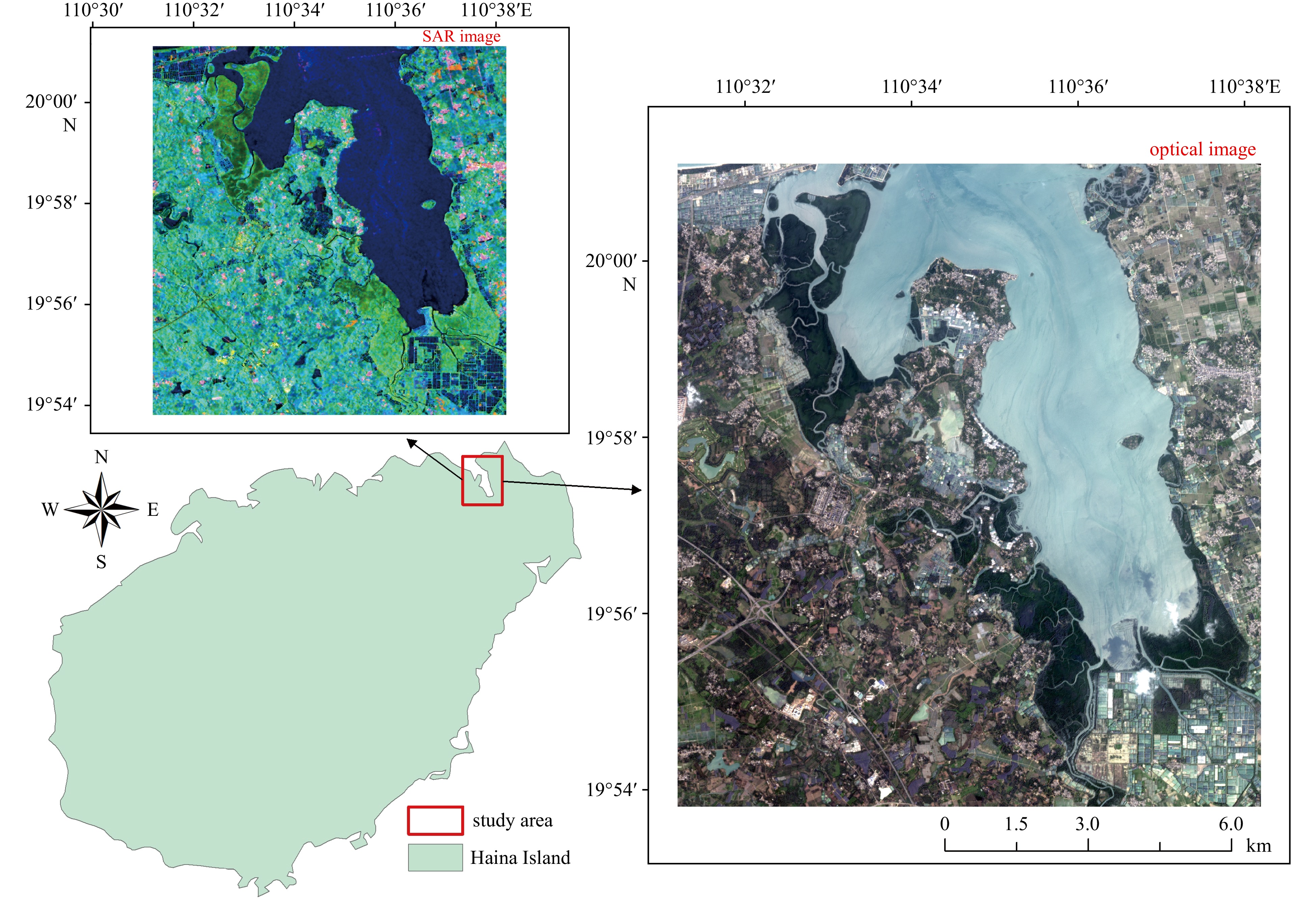
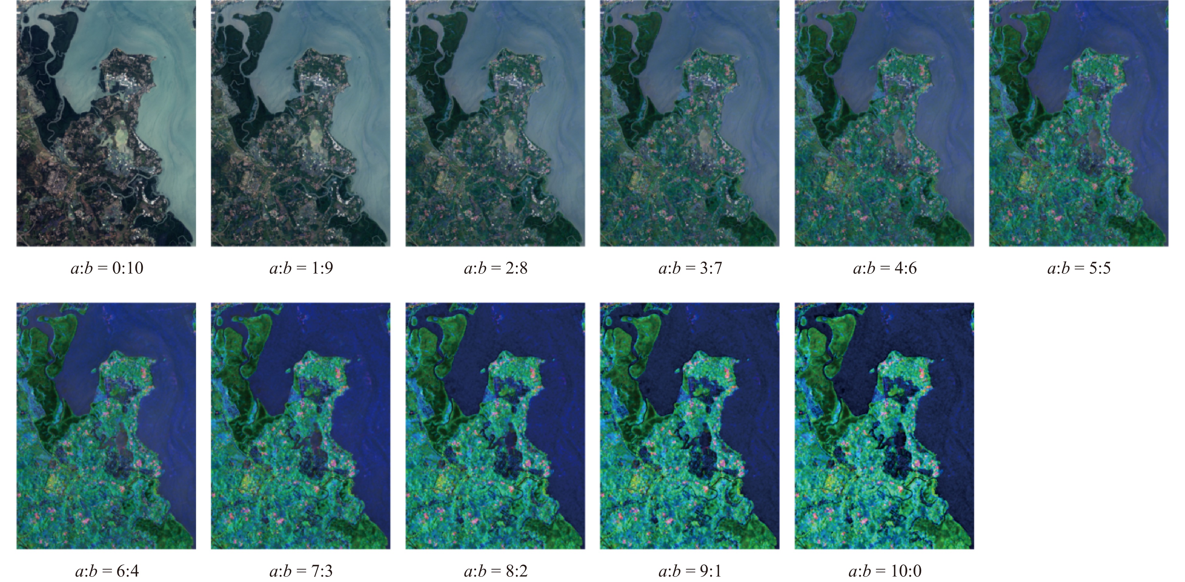
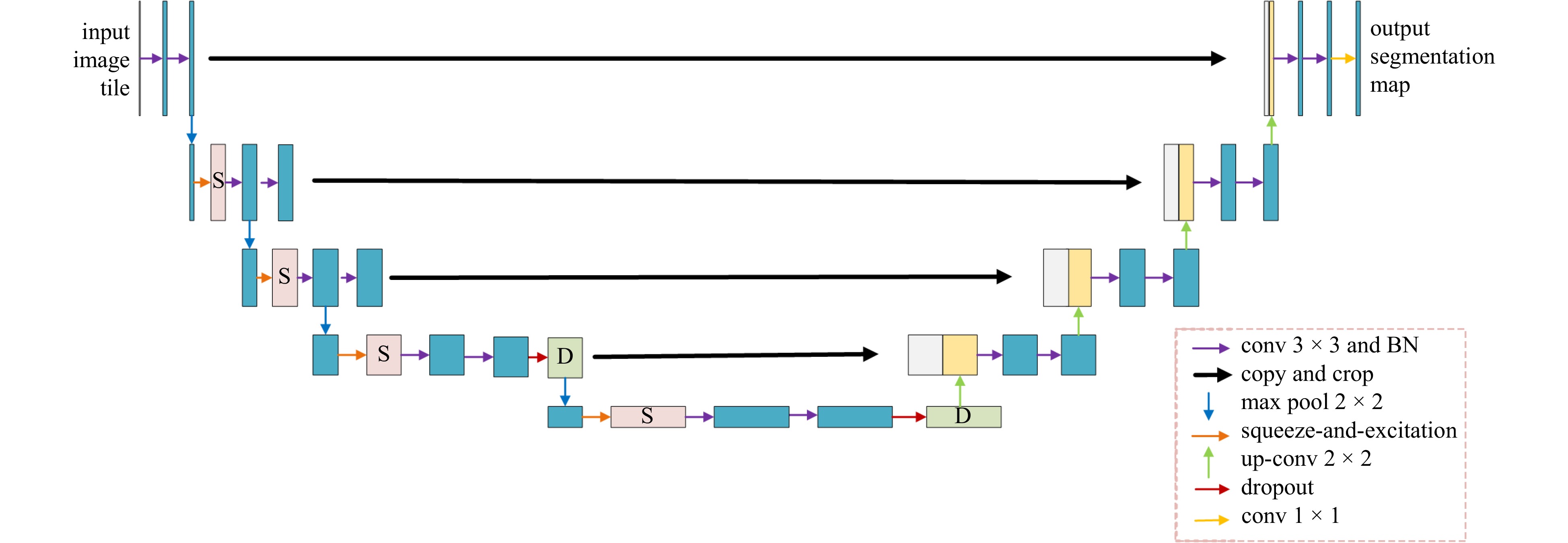
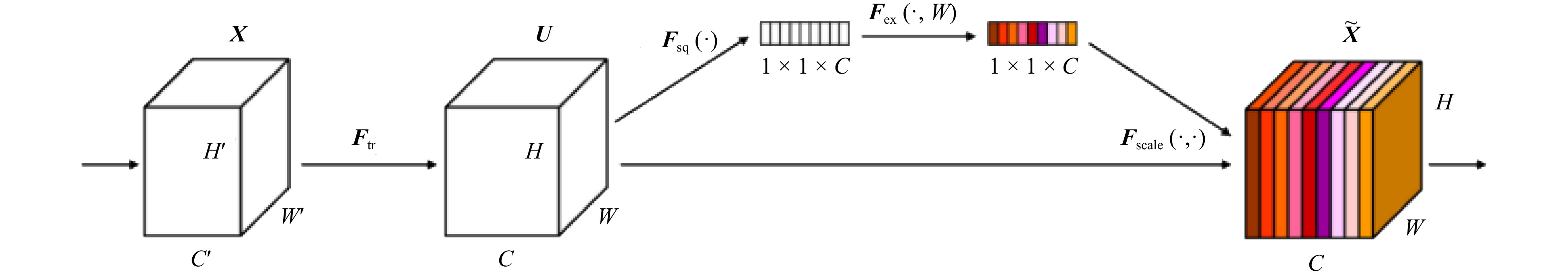
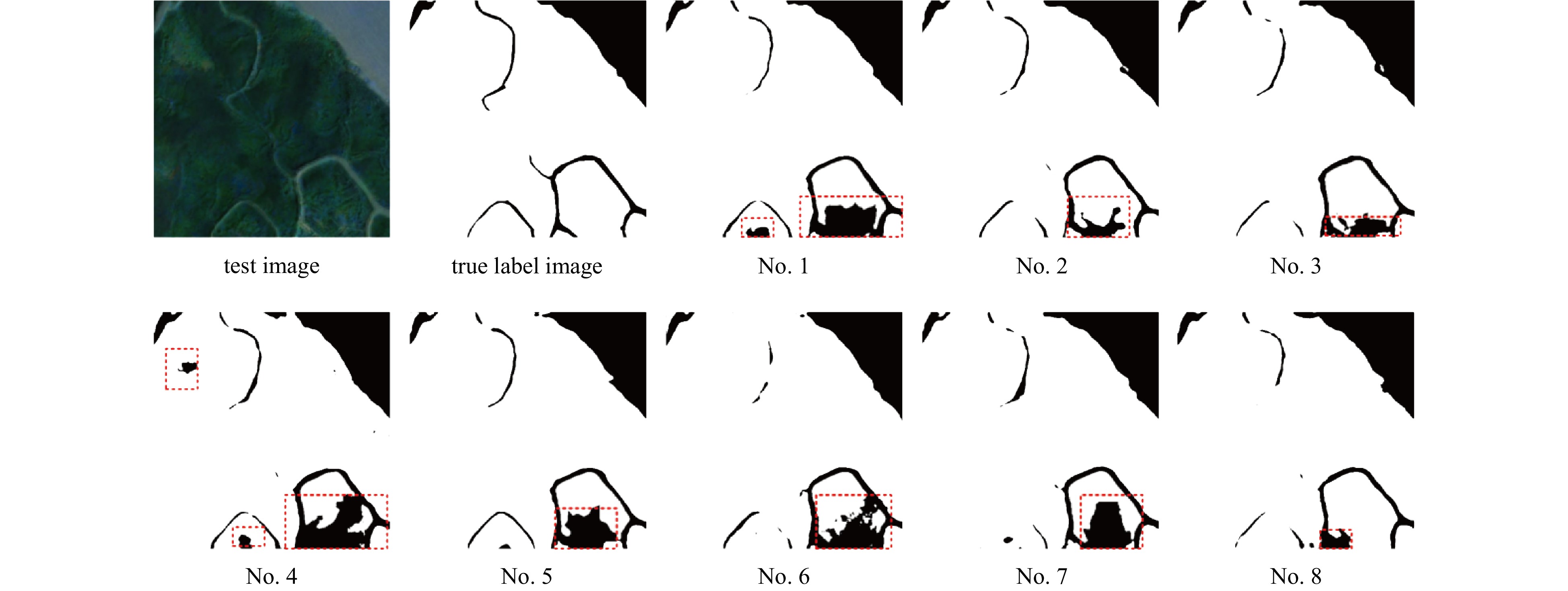
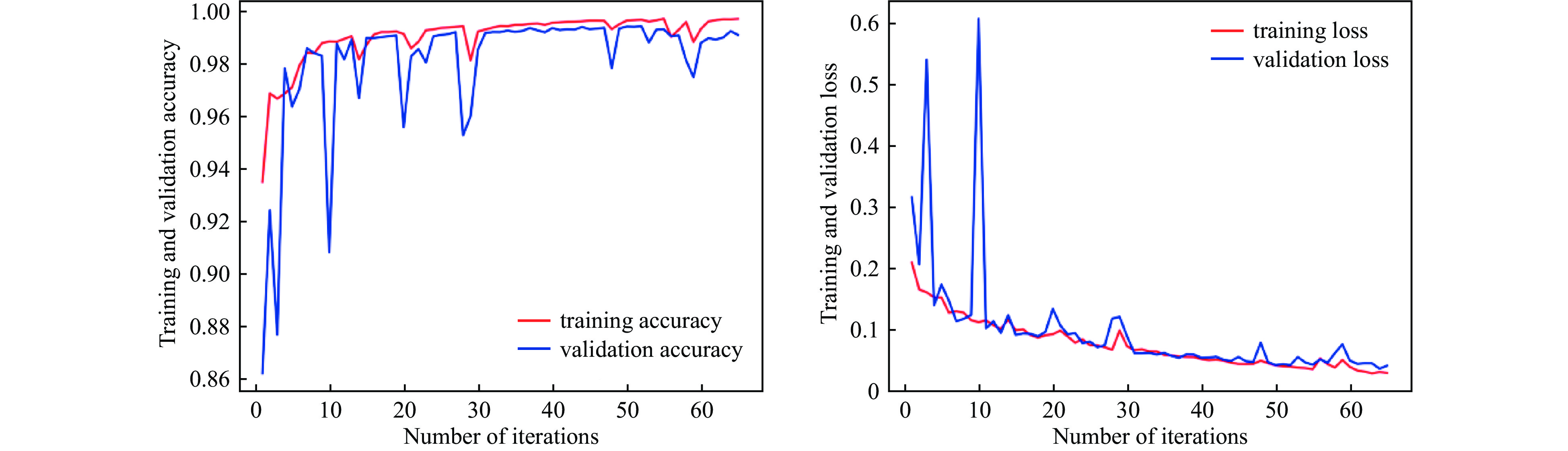
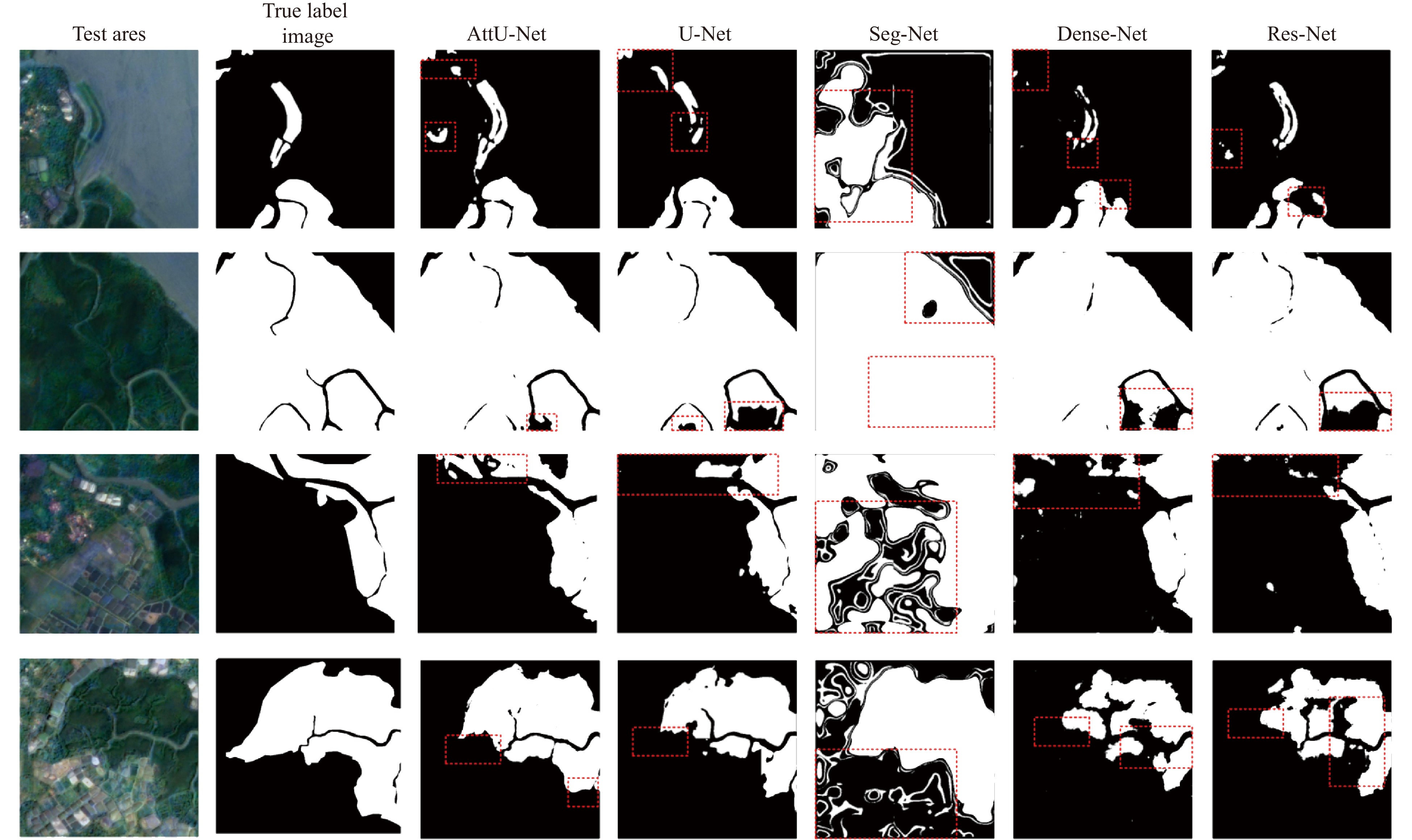
Mangroves are indispensable to coastlines, maintaining biodiversity, and mitigating climate change. Therefore, improving the accuracy of mangrove information identification is crucial for their ecological protection. Aiming at the limited morphological information of synthetic aperture radar (SAR) images, which is greatly interfered by noise, and the susceptibility of optical images to weather and lighting conditions, this paper proposes a pixel-level weighted fusion method for SAR and optical images. Image fusion enhanced the target features and made mangrove monitoring more comprehensive and accurate. To address the problem of high similarity between mangrove forests and other forests, this paper is based on the U-Net convolutional neural network, and an attention mechanism is added in the feature extraction stage to make the model pay more attention to the mangrove vegetation area in the image. In order to accelerate the convergence and normalize the input, batch normalization (BN) layer and Dropout layer are added after each convolutional layer. Since mangroves are a minority class in the image, an improved cross-entropy loss function is introduced in this paper to improve the model’s ability to recognize mangroves. The AttU-Net model for mangrove recognition in high similarity environments is thus constructed based on the fused images. Through comparison experiments, the overall accuracy of the improved U-Net model trained from the fused images to recognize the predicted regions is significantly improved. Based on the fused images, the recognition results of the AttU-Net model proposed in this paper are compared with its benchmark model, U-Net, and the Dense-Net, Res-Net, and Seg-Net methods. The AttU-Net model captured mangroves’ complex structures and textural features in images more effectively. The average OA, F1-score, and Kappa coefficient in the four tested regions were 94.406%, 90.006%, and 84.045%, which were significantly higher than several other methods. This method can provide some technical support for the monitoring and protection of mangrove ecosystems.
Mangroves are indispensable to coastlines, maintaining biodiversity, and mitigating climate change. Therefore, improving the accuracy of mangrove information identification is crucial for their ecological protection. Aiming at the limited morphological information of synthetic aperture radar (SAR) images, which is greatly interfered by noise, and the susceptibility of optical images to weather and lighting conditions, this paper proposes a pixel-level weighted fusion method for SAR and optical images. Image fusion enhanced the target features and made mangrove monitoring more comprehensive and accurate. To address the problem of high similarity between mangrove forests and other forests, this paper is based on the U-Net convolutional neural network, and an attention mechanism is added in the feature extraction stage to make the model pay more attention to the mangrove vegetation area in the image. In order to accelerate the convergence and normalize the input, batch normalization (BN) layer and Dropout layer are added after each convolutional layer. Since mangroves are a minority class in the image, an improved cross-entropy loss function is introduced in this paper to improve the model’s ability to recognize mangroves. The AttU-Net model for mangrove recognition in high similarity environments is thus constructed based on the fused images. Through comparison experiments, the overall accuracy of the improved U-Net model trained from the fused images to recognize the predicted regions is significantly improved. Based on the fused images, the recognition results of the AttU-Net model proposed in this paper are compared with its benchmark model, U-Net, and the Dense-Net, Res-Net, and Seg-Net methods. The AttU-Net model captured mangroves’ complex structures and textural features in images more effectively. The average OA, F1-score, and Kappa coefficient in the four tested regions were 94.406%, 90.006%, and 84.045%, which were significantly higher than several other methods. This method can provide some technical support for the monitoring and protection of mangrove ecosystems.

, Available online
Abstract:
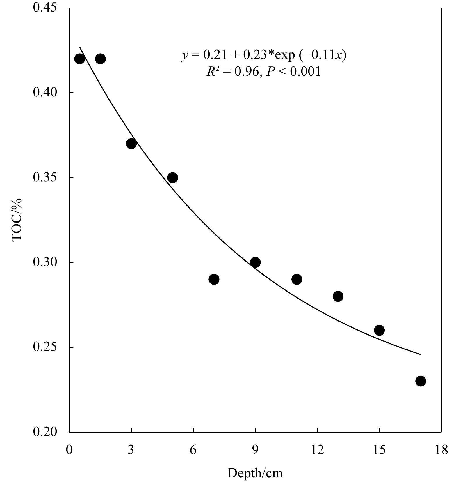
To understand the temporal and spatial variations in nutrient dynamics, as well as the potential cross-shelf transport of nutrients between the East China Sea (ECS) shelf and the Northwestern Pacific Ocean, six field observations covering the ECS were conducted in spring, summer, and autumn in 2011 and 2013. Nutrient dynamics in the ECS and nutrient exchange between shelf water and the open ocean were examined. High concentrations of dissolved inorganic nutrients were detected in the nearshore surface layer and offshore bottom layer in different seasons, and the concentrations of dissolved inorganic nutrients in surface seawater were lower in summer and autumn than in spring. The concentrations of dissolved organic nutrients in Kuroshio surface water were slightly lower in summer than in spring, but the concentrations in Kuroshio subsurface water were slightly higher in summer than in spring. There were abundant nutrient reservoirs in the euphotic zone of the ECS, which explained the high primary productivity. The evaluation of cross-shelf transport indicated that nutrients from shelf water were transported out across the 200 m isobath through the surface layer with the σ less than 23.0 kg/m3 in spring. The flux of dissolved inorganic nitrogen transported from the East China Sea shelf to the Northwest Pacific Ocean in spring was equivalent to 21% of the atmospheric nitrogen deposition in the Northwest Pacific Ocean. In summer, the onshore flux in the surface and bottom layers accounted for 80% of the total flux, and the transportation of nutrients along the surface layer to the continental shelf contributed to the nutrient storage and primary productivity of the euphotic zone in the ECS shelf in summer.
To understand the temporal and spatial variations in nutrient dynamics, as well as the potential cross-shelf transport of nutrients between the East China Sea (ECS) shelf and the Northwestern Pacific Ocean, six field observations covering the ECS were conducted in spring, summer, and autumn in 2011 and 2013. Nutrient dynamics in the ECS and nutrient exchange between shelf water and the open ocean were examined. High concentrations of dissolved inorganic nutrients were detected in the nearshore surface layer and offshore bottom layer in different seasons, and the concentrations of dissolved inorganic nutrients in surface seawater were lower in summer and autumn than in spring. The concentrations of dissolved organic nutrients in Kuroshio surface water were slightly lower in summer than in spring, but the concentrations in Kuroshio subsurface water were slightly higher in summer than in spring. There were abundant nutrient reservoirs in the euphotic zone of the ECS, which explained the high primary productivity. The evaluation of cross-shelf transport indicated that nutrients from shelf water were transported out across the 200 m isobath through the surface layer with the σ less than 23.0 kg/m3 in spring. The flux of dissolved inorganic nitrogen transported from the East China Sea shelf to the Northwest Pacific Ocean in spring was equivalent to 21% of the atmospheric nitrogen deposition in the Northwest Pacific Ocean. In summer, the onshore flux in the surface and bottom layers accounted for 80% of the total flux, and the transportation of nutrients along the surface layer to the continental shelf contributed to the nutrient storage and primary productivity of the euphotic zone in the ECS shelf in summer.


, Available online , doi: 10.1007/s13131-024-2362-3
Abstract:
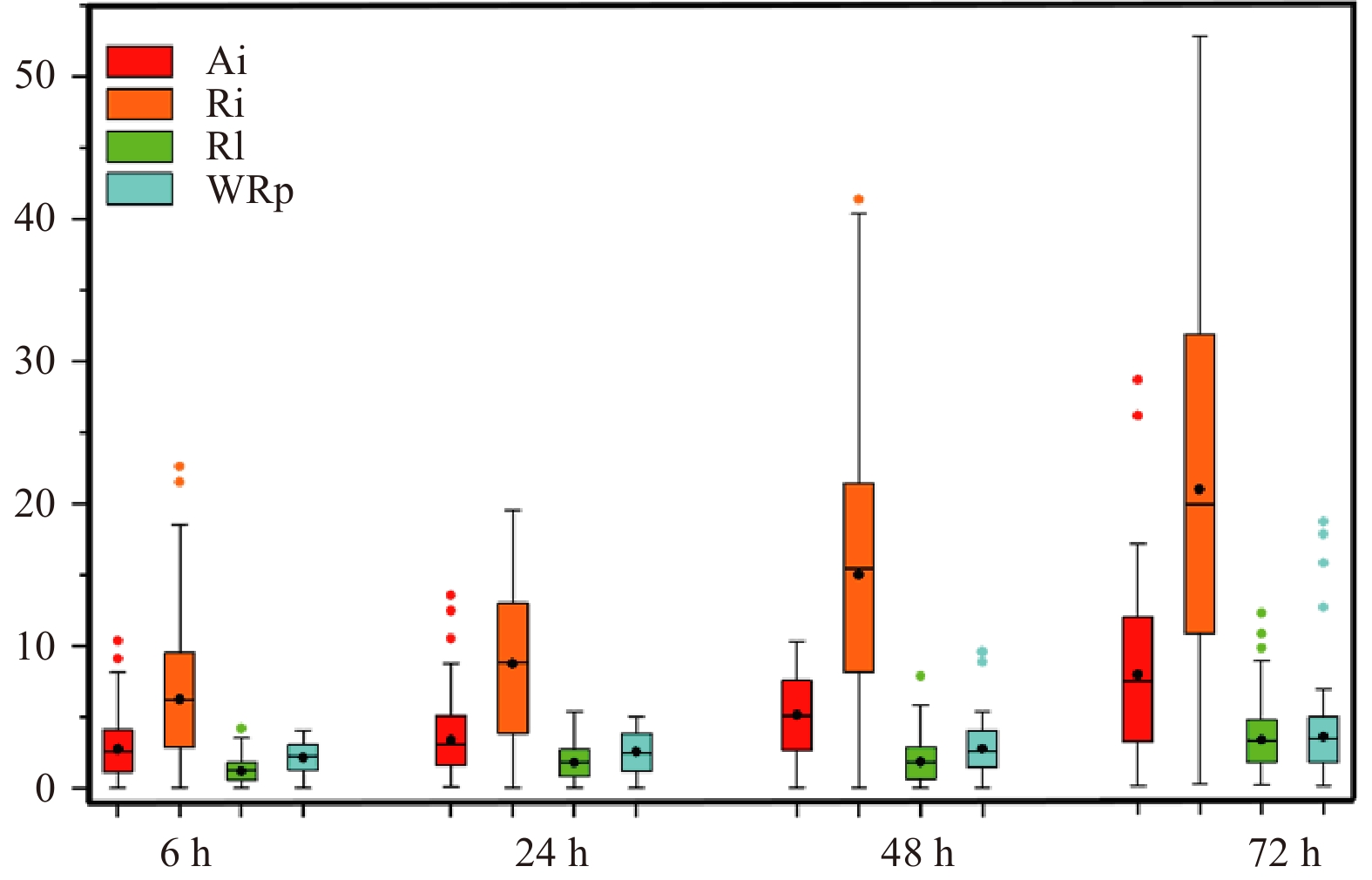
In the last 10 years (2012–2021), five hypoxic events have been observed in summer in the central Bohai Sea (CBS). Frequent and persistent hypoxia will have an impact on the ecosystem of the CBS. In this paper, historical sea temperature (ST), salinity (SAL), density (Den), and dissolved oxygen (DO) concentration data from three stations in the CBS are analyzed via the linear regression method, and the correlations between the stratification factors (ST, SAL, and Den) and DO concentration are determined. The thresholds of the stratification factors at the three stations in June in the year in which hypoxia occurred were determined and applied to survey data from 29 stations in late May to early June in 2022 in the CBS; this assessment found that the data from 19 stations indicated that hypoxia was about to occur. In August, the survey data showed that 14 out of the 29 stations indicated hypoxic conditions, of which 12 were from the predicted 19 stations, meaning that the estimation accuracy reached 63%. The same approach was applied to data from June 2023. The data for August from a bottom-type online monitoring system in the CBS verified the occurrence of hypoxic events around Station M2. The results show that the strength of the seawater stratification plays a leading role in hypoxic events in the summer in the CBS, and the thresholds of the stratification factors can be used to predict the occurrence of hypoxic events.
In the last 10 years (2012–2021), five hypoxic events have been observed in summer in the central Bohai Sea (CBS). Frequent and persistent hypoxia will have an impact on the ecosystem of the CBS. In this paper, historical sea temperature (ST), salinity (SAL), density (Den), and dissolved oxygen (DO) concentration data from three stations in the CBS are analyzed via the linear regression method, and the correlations between the stratification factors (ST, SAL, and Den) and DO concentration are determined. The thresholds of the stratification factors at the three stations in June in the year in which hypoxia occurred were determined and applied to survey data from 29 stations in late May to early June in 2022 in the CBS; this assessment found that the data from 19 stations indicated that hypoxia was about to occur. In August, the survey data showed that 14 out of the 29 stations indicated hypoxic conditions, of which 12 were from the predicted 19 stations, meaning that the estimation accuracy reached 63%. The same approach was applied to data from June 2023. The data for August from a bottom-type online monitoring system in the CBS verified the occurrence of hypoxic events around Station M2. The results show that the strength of the seawater stratification plays a leading role in hypoxic events in the summer in the CBS, and the thresholds of the stratification factors can be used to predict the occurrence of hypoxic events.


, Available online , doi: 10.1007/s13131-024-2381-0
Abstract:
The characteristics of the terrain of a strait can lead to a “fine tube” effect that enhances a monsoon and thereby affects the physical, chemical, and biological processes of marine ecosystems. This effect is a highly dynamic and complex phenomenon involving interactions among atmospheric, oceanic, and terrestrial systems, as well as biogeochemical cycles and biological responses driven by it. However, current understanding has been focused mainly on the differences between monsoons, and there have been few studies concerned with the weakening or strengthening of monsoons. To explore the biogeochemical and phytoplankton responses during varying intensities of the northeast (NE) monsoon in the Taiwan Strait (TWS), high-resolution, across-front observations combined with FerryBox online data and satellite observations were conducted in this study during a strong, moderate, and weak NE monsoon. The spatiotemporal changes of nutrient concentrations and phytoplankton communities were regulated by the dynamics of ocean currents forced by NE winds. The weakening of the NE monsoon caused shrinkage of the coastal currents that led to a reduction of nutrient concentrations and an alteration of the distribution patterns of phytoplankton communities along cross-front sections. Specifically, there was a notable decrease in the proportions of dinoflagellates and cryptophytes in inshore regions and of prasinophytes in offshore areas. This study showed for the first time the dynamics of phytoplankton with changes of ocean currents during varying intensities of the NE monsoon in a strait system. The findings helped to elucidate the general spatial patterns of the phytoplankton community based on satellite-derived surface temperature and wind patterns and further enhanced the understanding of biogeochemical cycles in marine systems.
The characteristics of the terrain of a strait can lead to a “fine tube” effect that enhances a monsoon and thereby affects the physical, chemical, and biological processes of marine ecosystems. This effect is a highly dynamic and complex phenomenon involving interactions among atmospheric, oceanic, and terrestrial systems, as well as biogeochemical cycles and biological responses driven by it. However, current understanding has been focused mainly on the differences between monsoons, and there have been few studies concerned with the weakening or strengthening of monsoons. To explore the biogeochemical and phytoplankton responses during varying intensities of the northeast (NE) monsoon in the Taiwan Strait (TWS), high-resolution, across-front observations combined with FerryBox online data and satellite observations were conducted in this study during a strong, moderate, and weak NE monsoon. The spatiotemporal changes of nutrient concentrations and phytoplankton communities were regulated by the dynamics of ocean currents forced by NE winds. The weakening of the NE monsoon caused shrinkage of the coastal currents that led to a reduction of nutrient concentrations and an alteration of the distribution patterns of phytoplankton communities along cross-front sections. Specifically, there was a notable decrease in the proportions of dinoflagellates and cryptophytes in inshore regions and of prasinophytes in offshore areas. This study showed for the first time the dynamics of phytoplankton with changes of ocean currents during varying intensities of the NE monsoon in a strait system. The findings helped to elucidate the general spatial patterns of the phytoplankton community based on satellite-derived surface temperature and wind patterns and further enhanced the understanding of biogeochemical cycles in marine systems.


, Available online , doi: 10.1007/s13131-024-2303-1
Abstract:
Macrobenthic organisms are commonly employed as biomonitors for environmental risk assessment. In this study, we aimed to investigate the spatial and temporal patterns of the macrobenthic community, which is influenced by environmental factors of sediments and bottom water layer. We sampled a total of 12, 11, 10, and 11 stations in the Shengsi Archipelago during June 2010, August 2010, November 2020, and April 2021 respectively. A total of 124 species of macrobenthos were identified, with polychaetes being the dominant group. The abundance, biomass, and diversity indices exhibited no significant temporal differences. Similarly, biodiversity did not exhibit a clear spatial gradient, likely due to the small study area and the absence of significant differences in key factors such as depth. However, the stations with the lowest biodiversity values consistently appeared in the southwest region, possibly due to the impact of human activities. Significant differences in the macrobenthic community were observed between all months except between June and August, and mollusk Endopleura lubrica and polychaete Sigambra hanaokai were important contributors to these differences according to the results of the Similarity Percentages analysis. Suspended particulate matter (SPM) was identified as the primary driving factors of macrobenthic variability. In summary, the community structure underwent temporal changes influenced by complex current patterns, while biodiversity remained relatively stable. This study contributes to our understanding of the key environmental factors affecting macrobenthic communities and biodiversity. It also provides valuable data support for the long-term monitoring of macrobenthos and the environment in the Shengsi Archipelago.
Macrobenthic organisms are commonly employed as biomonitors for environmental risk assessment. In this study, we aimed to investigate the spatial and temporal patterns of the macrobenthic community, which is influenced by environmental factors of sediments and bottom water layer. We sampled a total of 12, 11, 10, and 11 stations in the Shengsi Archipelago during June 2010, August 2010, November 2020, and April 2021 respectively. A total of 124 species of macrobenthos were identified, with polychaetes being the dominant group. The abundance, biomass, and diversity indices exhibited no significant temporal differences. Similarly, biodiversity did not exhibit a clear spatial gradient, likely due to the small study area and the absence of significant differences in key factors such as depth. However, the stations with the lowest biodiversity values consistently appeared in the southwest region, possibly due to the impact of human activities. Significant differences in the macrobenthic community were observed between all months except between June and August, and mollusk Endopleura lubrica and polychaete Sigambra hanaokai were important contributors to these differences according to the results of the Similarity Percentages analysis. Suspended particulate matter (SPM) was identified as the primary driving factors of macrobenthic variability. In summary, the community structure underwent temporal changes influenced by complex current patterns, while biodiversity remained relatively stable. This study contributes to our understanding of the key environmental factors affecting macrobenthic communities and biodiversity. It also provides valuable data support for the long-term monitoring of macrobenthos and the environment in the Shengsi Archipelago.


, Available online , doi: 10.1007/s13131-024-2350-7
Abstract:
Typhoons in the Western Pacific have a significant impact on the transport of heat, salt and particles through the Luzon Strait. However, there are very limited field observations of this impact because of extreme difficulties and even dangers for ship-based measurements during the rough weather. Here, we present the preliminary results from analyzing a dataset collected by a glider deployed west of the Luzon Strait a few days prior to the arrival of typhoon “MITAG”. The gilder data revealed an abnormally salinity (>34.8) subsurface water apparently sourced from Kuroshio intrusion during the typhoon. When typhoon “MITAG” traveled on the east of the Luzon Strait, the positive wind stress curl strengthened the cyclonic eddy and weakened the anti-cyclonic eddy. This led to a slowdown of Kuroshio and made its intrusion easier. The main axis of the Kuroshio at the northern part of the strait shifted westward after the typhoon and did not return to its original position until a week later. The Ekman transport from persistent northerly wind of typhoon “MITAG” was significant, but its importance in enhancing the Kuroshio intrusion is only secondary relative to the eddies variations.
Typhoons in the Western Pacific have a significant impact on the transport of heat, salt and particles through the Luzon Strait. However, there are very limited field observations of this impact because of extreme difficulties and even dangers for ship-based measurements during the rough weather. Here, we present the preliminary results from analyzing a dataset collected by a glider deployed west of the Luzon Strait a few days prior to the arrival of typhoon “MITAG”. The gilder data revealed an abnormally salinity (>34.8) subsurface water apparently sourced from Kuroshio intrusion during the typhoon. When typhoon “MITAG” traveled on the east of the Luzon Strait, the positive wind stress curl strengthened the cyclonic eddy and weakened the anti-cyclonic eddy. This led to a slowdown of Kuroshio and made its intrusion easier. The main axis of the Kuroshio at the northern part of the strait shifted westward after the typhoon and did not return to its original position until a week later. The Ekman transport from persistent northerly wind of typhoon “MITAG” was significant, but its importance in enhancing the Kuroshio intrusion is only secondary relative to the eddies variations.


, Available online , doi: 10.1007/s13131-024-2353-4
Abstract:
The element iron limitation is one of the crucial factors contributing to High Nutrient Low Chlorophyll in the Southern Ocean (SO). Mixed layer dynamics regulate the availability of iron to phytoplankton. In this study, we investigate the influence of surface iron supplementation triggered by the mixed layer depth (MLD) variation on chlorophyll-a concentration (Chl-a) in the SO on seasonal and interannual timescales. This analysis is based on the Biogeochemical Southern Ocean State Estimate for the period from 2013 to 2021. We provide a comprehensive and systematic mapping of the regions within the SO, where Chl-a is affected by iron input related to MLD deepening. The relationship between the MLD and the Chl-a varies with the latitude on the seasonal time scale. Both the MLD and sea ice melting affect the distribution of Chl-a. On the interannual scale, iron supply due to MLD deepening occurs primarily north of 60°S. Horizontal advection-induced entrainment enhances the surface iron input during the austral summer, which favors Chl-a increase. In addition to the MLD, the melting of sea ice and cooling of the sea surface can also alter iron input and subsequently affect Chl-a distribution in the austral summer. During the austral winter, entrainment can boost iron stocks, stimulating a subsequent spring increase of Chl-a in the SO. Furthermore, sea surface temperature declines during the austral winter, promoting an increased iron supply and creating favorable conditions for the subsequent spring Chl-a increase in the SO.
The element iron limitation is one of the crucial factors contributing to High Nutrient Low Chlorophyll in the Southern Ocean (SO). Mixed layer dynamics regulate the availability of iron to phytoplankton. In this study, we investigate the influence of surface iron supplementation triggered by the mixed layer depth (MLD) variation on chlorophyll-a concentration (Chl-a) in the SO on seasonal and interannual timescales. This analysis is based on the Biogeochemical Southern Ocean State Estimate for the period from 2013 to 2021. We provide a comprehensive and systematic mapping of the regions within the SO, where Chl-a is affected by iron input related to MLD deepening. The relationship between the MLD and the Chl-a varies with the latitude on the seasonal time scale. Both the MLD and sea ice melting affect the distribution of Chl-a. On the interannual scale, iron supply due to MLD deepening occurs primarily north of 60°S. Horizontal advection-induced entrainment enhances the surface iron input during the austral summer, which favors Chl-a increase. In addition to the MLD, the melting of sea ice and cooling of the sea surface can also alter iron input and subsequently affect Chl-a distribution in the austral summer. During the austral winter, entrainment can boost iron stocks, stimulating a subsequent spring increase of Chl-a in the SO. Furthermore, sea surface temperature declines during the austral winter, promoting an increased iron supply and creating favorable conditions for the subsequent spring Chl-a increase in the SO.


, Available online , doi: 10.1007/s13131-024-2363-2
Abstract:
Forecasting of ocean currents is critical for both marine meteorological research and ocean engineering and construction. Timely and accurate forecasting of coastal current velocities offers a scientific foundation and decision support for multiple practices such as search and rescue, disaster avoidance and remediation, and offshore construction. This research established a framework to generate short-term surface current forecasts based on ensemble machine learning trained on High Frequency radar observation. Results indicate that an ensemble algorithm that used random forests to filter forecasting features by weighting them, and then used the AdaBoost method to forecast can significantly reduce the model training time, while ensuring the model forecasting effectiveness, with great economic benefits. Model accuracy is a function of surface current variability and the forecasting horizon. In order to improve the forecasting capability and accuracy of the model, the model structure of the ensemble algorithm was optimized, and the random forest algorithm was used to dynamically select model features. The results show that the error variation of the optimized surface current forecasting model has a more regular error variation, and the importance of the features varies with the forecasting time-step. At ten-step ahead forecasting horizon the model reported RMSE, MAE and correlation coefficient by 2.84 cm/s, 2.02 cm/s, and 0.96, respectively. The model error is affected by factors such as topography, boundaries, and geometric accuracy of the observation system. This paper demonstrates the potential of ensemble-based machine learning algorithm to improve forecasting of ocean currents.
Forecasting of ocean currents is critical for both marine meteorological research and ocean engineering and construction. Timely and accurate forecasting of coastal current velocities offers a scientific foundation and decision support for multiple practices such as search and rescue, disaster avoidance and remediation, and offshore construction. This research established a framework to generate short-term surface current forecasts based on ensemble machine learning trained on High Frequency radar observation. Results indicate that an ensemble algorithm that used random forests to filter forecasting features by weighting them, and then used the AdaBoost method to forecast can significantly reduce the model training time, while ensuring the model forecasting effectiveness, with great economic benefits. Model accuracy is a function of surface current variability and the forecasting horizon. In order to improve the forecasting capability and accuracy of the model, the model structure of the ensemble algorithm was optimized, and the random forest algorithm was used to dynamically select model features. The results show that the error variation of the optimized surface current forecasting model has a more regular error variation, and the importance of the features varies with the forecasting time-step. At ten-step ahead forecasting horizon the model reported RMSE, MAE and correlation coefficient by 2.84 cm/s, 2.02 cm/s, and 0.96, respectively. The model error is affected by factors such as topography, boundaries, and geometric accuracy of the observation system. This paper demonstrates the potential of ensemble-based machine learning algorithm to improve forecasting of ocean currents.


, Available online , doi: 10.1007/s13131-024-2358-z
Abstract:
The three-dimensional displacements caused by ocean loading effects are significant enough to impact spatial geodetic measurements on sub-daily or longer timescales, particularly in the vertical direction. Currently, most tide models incorporate the distribution of vertical displacement loading tides; however, their accuracy has not been assessed for the equatorial and Indian Ocean regions. Global Positioning System (GPS) observations provide high-precision data on sea-level changes, enabling the assessment of the accuracy and reliability of vertical displacement tide models. However, because the tidal period of the K2 constituent is almost identical to the orbital period of GPS constellations, the estimation of the K2 tidal constituent from GPS observations is not satisfactory. In this study, the principle of smoothness is employed to correct the systematic error in K2 estimates in GPS observations through quadratic fitting. Using the adjusted harmonic constants from 31 GPS stations for the equatorial and Indian Ocean, the accuracy of eight major constituents from five global vertical displacement tide models (FES2014, EOT11a, GOT4.10c, GOT4.8, and NAO.99b) is evaluated for the equatorial and Indian Ocean. The results indicate that the EOT11a and FES2014 models exhibit higher accuracy in the vertical displacement tide models for the equatorial and Indian Ocean, with root sum squares (RSS) errors of 2.29 mm and 2.34 mm, respectively. Furthermore, a brief analysis of the vertical displacement tide distribution characteristics of the eight major constituents for the equatorial and Indian Ocean was conducted using the EOT11a model.
The three-dimensional displacements caused by ocean loading effects are significant enough to impact spatial geodetic measurements on sub-daily or longer timescales, particularly in the vertical direction. Currently, most tide models incorporate the distribution of vertical displacement loading tides; however, their accuracy has not been assessed for the equatorial and Indian Ocean regions. Global Positioning System (GPS) observations provide high-precision data on sea-level changes, enabling the assessment of the accuracy and reliability of vertical displacement tide models. However, because the tidal period of the K2 constituent is almost identical to the orbital period of GPS constellations, the estimation of the K2 tidal constituent from GPS observations is not satisfactory. In this study, the principle of smoothness is employed to correct the systematic error in K2 estimates in GPS observations through quadratic fitting. Using the adjusted harmonic constants from 31 GPS stations for the equatorial and Indian Ocean, the accuracy of eight major constituents from five global vertical displacement tide models (FES2014, EOT11a, GOT4.10c, GOT4.8, and NAO.99b) is evaluated for the equatorial and Indian Ocean. The results indicate that the EOT11a and FES2014 models exhibit higher accuracy in the vertical displacement tide models for the equatorial and Indian Ocean, with root sum squares (RSS) errors of 2.29 mm and 2.34 mm, respectively. Furthermore, a brief analysis of the vertical displacement tide distribution characteristics of the eight major constituents for the equatorial and Indian Ocean was conducted using the EOT11a model.


, Available online , doi: 10.1007/s13131-024-2355-2
Abstract:
During August and September 2023, three giant icebergs, each bigger than Paris, successively grazed Clarence Island in the northeast of the Antarctic Peninsula, a home to a population of over 100 000 penguins. This incident may serve as a clarion call for the increasing iceberg calving due to global warming and its subsequent impact on the Antarctic ecosystem. Here we investigate this unexpected event and employ historical records and probabilistic analyses of iceberg grounding to assess the degree of impact on penguin colonies of Clarence Island. Among the eleven colonies, there is one with low impact, eight with medium impact, and two with high impact. The low-impact colony, Cape Lloyd, is located in the northern part of the island, while the high-impact colonies, False Ridge and Pink Pool, are in the southeast. The eight medium-impact colonies are distributed along both the eastern and western coasts of the island. This study provides essential support for evaluating the impact of iceberg activity on penguin colonies. We argue that penguin colonies located in areas prone to iceberg drift, such as Clarence Island, may become more vulnerable to the heightened risk of iceberg collisions or groundings in the warming future. Therefore, we hope the public will become more aware of the grave impacts of climate change on penguins and underscore the urgent need for effective conservation strategies.
During August and September 2023, three giant icebergs, each bigger than Paris, successively grazed Clarence Island in the northeast of the Antarctic Peninsula, a home to a population of over 100 000 penguins. This incident may serve as a clarion call for the increasing iceberg calving due to global warming and its subsequent impact on the Antarctic ecosystem. Here we investigate this unexpected event and employ historical records and probabilistic analyses of iceberg grounding to assess the degree of impact on penguin colonies of Clarence Island. Among the eleven colonies, there is one with low impact, eight with medium impact, and two with high impact. The low-impact colony, Cape Lloyd, is located in the northern part of the island, while the high-impact colonies, False Ridge and Pink Pool, are in the southeast. The eight medium-impact colonies are distributed along both the eastern and western coasts of the island. This study provides essential support for evaluating the impact of iceberg activity on penguin colonies. We argue that penguin colonies located in areas prone to iceberg drift, such as Clarence Island, may become more vulnerable to the heightened risk of iceberg collisions or groundings in the warming future. Therefore, we hope the public will become more aware of the grave impacts of climate change on penguins and underscore the urgent need for effective conservation strategies.


, Available online , doi: 10.1007/s13131-024-2359-y
Abstract:
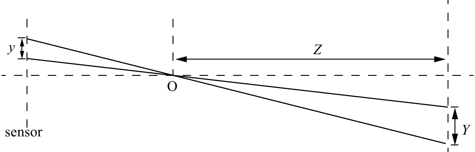
Wave information retrieval from videos captured by a single camera has been increasingly applied in marine observation. However, when the camera observes ocean waves at low grazing angles, the accurate extraction of wave information from videos will be effected by the interference of the fine ripples on the sea surface. To solve this problem, this study develops a method for estimating peak wave periods from videos captured at low grazing angles. The method extracts the motion of the sea surface texture from the video and obtains the peak wave period via the spectral analysis. The calculation results captured from real-world videos are compared with those obtained from X-band radar inversion and tracking buoy movement, with maximum deviations of 8% and 14%, respectively. The analysis of the results shows that the peak wave period of the method has good stability. In addition, this paper uses a pinhole camera model to convert the displacement of the texture from pixel height to actual height and performs moving average filtering on the displacement of the texture, thus conducting a preliminary exploration of the inversion of significant wave height. This study helps to extend the application of sea surface videos.
Wave information retrieval from videos captured by a single camera has been increasingly applied in marine observation. However, when the camera observes ocean waves at low grazing angles, the accurate extraction of wave information from videos will be effected by the interference of the fine ripples on the sea surface. To solve this problem, this study develops a method for estimating peak wave periods from videos captured at low grazing angles. The method extracts the motion of the sea surface texture from the video and obtains the peak wave period via the spectral analysis. The calculation results captured from real-world videos are compared with those obtained from X-band radar inversion and tracking buoy movement, with maximum deviations of 8% and 14%, respectively. The analysis of the results shows that the peak wave period of the method has good stability. In addition, this paper uses a pinhole camera model to convert the displacement of the texture from pixel height to actual height and performs moving average filtering on the displacement of the texture, thus conducting a preliminary exploration of the inversion of significant wave height. This study helps to extend the application of sea surface videos.


Observed features of stable surface seawater isotopes across the Pacific, Indian and Southern oceans
, Available online , doi: 10.1007/s13131-024-2378-8
Abstract:
The marine hydrological process is still unclear due to scarce observations. Based on stable water isotopes in surface seawater along the 33rd Chinese National Antarctic Science Expedition from November 2016 to April 2017, this study explored the hydrological processes in the Pacific, Indian and Southern Oceans. The results show that the Northwest Pacific (0—26° N) is a region with strong evaporation (the δ18O-δD slope is 6.58), while the southern Indian Ocean is a region with strong precipitation (the δ18O-δD slope is 9.57). The influence of continental runoff and water mass mixing reduces the correlation between δ18O and salinity in the eastern Indian Ocean. The characteristics of the isotopes and hydrological parameters indicate that the Agulhas front and subtropical convergence do not merge in the Antarctic–Indian Ocean region. The freezing of sea ice near the Antarctic continent decreases the δ18O and δD by 0.40‰ and 7.0‰, respectively, compared with those near 67°S. This study is helpful for understanding marine hydrological processes and promoting the understanding and research of the nature of ocean responses in the context of climate change.
The marine hydrological process is still unclear due to scarce observations. Based on stable water isotopes in surface seawater along the 33rd Chinese National Antarctic Science Expedition from November 2016 to April 2017, this study explored the hydrological processes in the Pacific, Indian and Southern Oceans. The results show that the Northwest Pacific (0—26° N) is a region with strong evaporation (the δ18O-δD slope is 6.58), while the southern Indian Ocean is a region with strong precipitation (the δ18O-δD slope is 9.57). The influence of continental runoff and water mass mixing reduces the correlation between δ18O and salinity in the eastern Indian Ocean. The characteristics of the isotopes and hydrological parameters indicate that the Agulhas front and subtropical convergence do not merge in the Antarctic–Indian Ocean region. The freezing of sea ice near the Antarctic continent decreases the δ18O and δD by 0.40‰ and 7.0‰, respectively, compared with those near 67°S. This study is helpful for understanding marine hydrological processes and promoting the understanding and research of the nature of ocean responses in the context of climate change.


, Available online , doi: 10.1007/s13131-024-2351-6
Abstract:
The long-term dynamic evolution and underlying mechanisms of coastal landscape pattern stability, driven by strong anthropogenic interference and consequently climate change, are topics of major interest in national and international scientific research. Guangdong Province, located in southeastern China, has been undergoing rapid urbanization over several decades. In this study, we quantitatively determined the scale threshold characteristics of coastal landscape pattern stability in Guangdong Province, from the dual perspective of spatial heterogeneity and spatial autocorrelation. An analysis of the spatiotemporal evolution of the coastal landscape was conducted after the optical scale was determined. Then, we applied the geodetector statistical method to quantitatively explore the mechanisms underlying coastal landscape pattern stability. Based on the inflection point of landscape metrics and the maximum value of the Moran I index, the optimal scale for analyzing coastal landscape pattern stability in Guangdong Province was 240 m × 240 m. Within the past several decades, coastal landscape pattern stability increased slightly and then decreased, with a turning point around 2005. The most significant variations in coastal landscape pattern stability were observed in the transition zone of rural-urban expansion. A q-statistics analysis showed that the explanatory power of paired factors was greater than that of a single driving factor; the paired factors with the greatest impact on coastal landscape pattern stability in Guangdong Province were the change in gross industrial output and change in average annual precipitation from 2010 to 2015, based on a q value of 0.604. These results will contribute to future efforts to achieve sustainable coastal development and provide a scientific basis and technical support for the rational planning and utilization of resources in large estuarine areas, including marine disaster prevention and seawall ecological restoration.
The long-term dynamic evolution and underlying mechanisms of coastal landscape pattern stability, driven by strong anthropogenic interference and consequently climate change, are topics of major interest in national and international scientific research. Guangdong Province, located in southeastern China, has been undergoing rapid urbanization over several decades. In this study, we quantitatively determined the scale threshold characteristics of coastal landscape pattern stability in Guangdong Province, from the dual perspective of spatial heterogeneity and spatial autocorrelation. An analysis of the spatiotemporal evolution of the coastal landscape was conducted after the optical scale was determined. Then, we applied the geodetector statistical method to quantitatively explore the mechanisms underlying coastal landscape pattern stability. Based on the inflection point of landscape metrics and the maximum value of the Moran I index, the optimal scale for analyzing coastal landscape pattern stability in Guangdong Province was 240 m × 240 m. Within the past several decades, coastal landscape pattern stability increased slightly and then decreased, with a turning point around 2005. The most significant variations in coastal landscape pattern stability were observed in the transition zone of rural-urban expansion. A q-statistics analysis showed that the explanatory power of paired factors was greater than that of a single driving factor; the paired factors with the greatest impact on coastal landscape pattern stability in Guangdong Province were the change in gross industrial output and change in average annual precipitation from 2010 to 2015, based on a q value of 0.604. These results will contribute to future efforts to achieve sustainable coastal development and provide a scientific basis and technical support for the rational planning and utilization of resources in large estuarine areas, including marine disaster prevention and seawall ecological restoration.


, Available online
Abstract:
Sediment-laden sea ice plays an important role in Arctic sediment transport and biogeochemical cycles, as well as the shortwave radiation budget and melt onset of ice surface. However, at present, there is a lack of efficient observation approach from both space and in situ for the coverage of Arctic sediment-laden sea ice. Thus, both spatial distribution and long-term changes in area fraction of such ice floes are still unclear. This study proposes a new classification method to extract Arctic sediment-laden sea ice on the basic of the difference in spectral characteristics between sediment-laden sea ice and clean sea ice in the visible band using the MOD09A1 data with the resolution of 500 m, and obtains its area fraction over the pan Arctic Ocean during 2000−2021. Compared with Landsat-8 true color verification images with a resolution of 30 m, the overall accuracy of our classification method is 92.3%, and the Kappa coefficient is 0.84. The impact of clouds on the results of recognition and spatiotemporal changes of sediment-laden sea ice is relatively small from June to July, compared to that in May or August. Spatially, sediment-laden sea ice mostly appears over the marginal seas of the Arctic Ocean, especially the continental shelf of Chukchi Sea and the Siberian Seas. Associated with the retreat of Arctic sea ice extent, the total area of sediment-laden sea ice in June–July also shows a significant decreasing trend of 8.99 × 10⁴ km2 per year. The occurrence of sediment-laden sea ice over the Arctic Ocean in June–July leads to the reduce of surface albedo over the ice-covered ocean by 14.1%. This study will help thoroughly understanding of the role of sediment-laden sea ice in the evolution of Arctic climate system and marine ecological environment, as well as the heat budget and mass balance of sea ice itself.
Sediment-laden sea ice plays an important role in Arctic sediment transport and biogeochemical cycles, as well as the shortwave radiation budget and melt onset of ice surface. However, at present, there is a lack of efficient observation approach from both space and in situ for the coverage of Arctic sediment-laden sea ice. Thus, both spatial distribution and long-term changes in area fraction of such ice floes are still unclear. This study proposes a new classification method to extract Arctic sediment-laden sea ice on the basic of the difference in spectral characteristics between sediment-laden sea ice and clean sea ice in the visible band using the MOD09A1 data with the resolution of 500 m, and obtains its area fraction over the pan Arctic Ocean during 2000−2021. Compared with Landsat-8 true color verification images with a resolution of 30 m, the overall accuracy of our classification method is 92.3%, and the Kappa coefficient is 0.84. The impact of clouds on the results of recognition and spatiotemporal changes of sediment-laden sea ice is relatively small from June to July, compared to that in May or August. Spatially, sediment-laden sea ice mostly appears over the marginal seas of the Arctic Ocean, especially the continental shelf of Chukchi Sea and the Siberian Seas. Associated with the retreat of Arctic sea ice extent, the total area of sediment-laden sea ice in June–July also shows a significant decreasing trend of 8.99 × 10⁴ km2 per year. The occurrence of sediment-laden sea ice over the Arctic Ocean in June–July leads to the reduce of surface albedo over the ice-covered ocean by 14.1%. This study will help thoroughly understanding of the role of sediment-laden sea ice in the evolution of Arctic climate system and marine ecological environment, as well as the heat budget and mass balance of sea ice itself.


, Available online , doi: 10.1007/s13131-024-2313-z
Abstract:
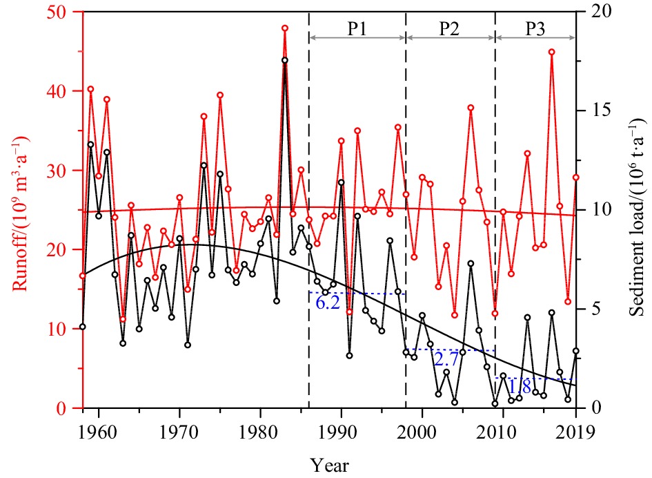
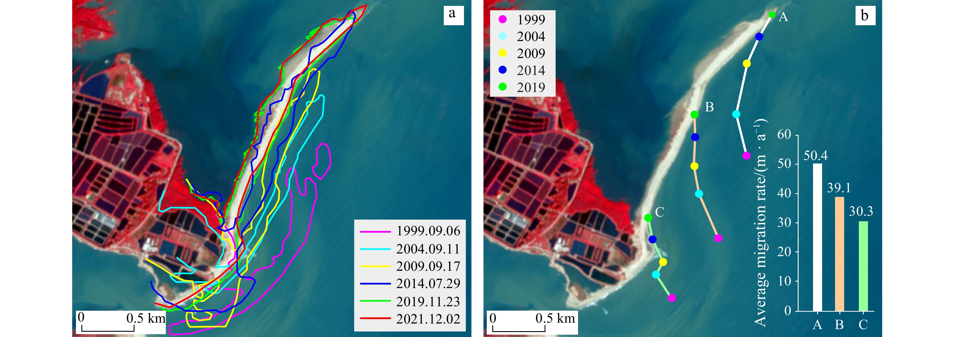
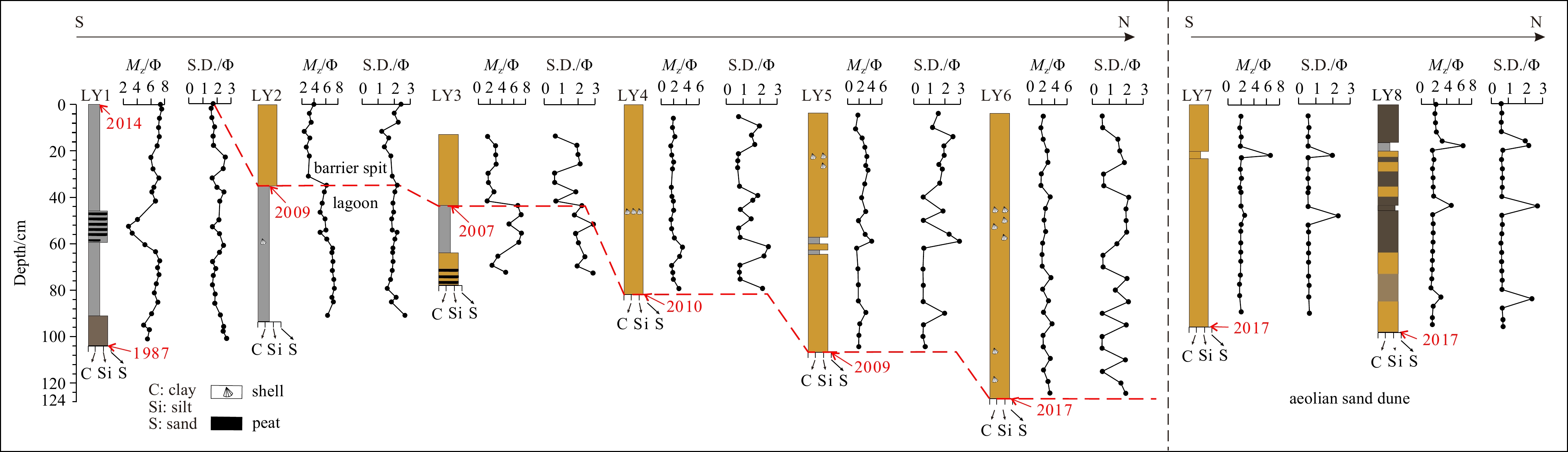
The deltas serve as the primary interactive zone where terrestrial and marine environments converge, playing a pivotal role in the coastal deposition. In the Holocene, climate changes and sea level fluctuation are the principal driving factors in the evolution of deltas. However, human activities such as the construction of dams and reservoirs in the Anthropocene have significantly altered sediment transport in rivers, leading to depositional pattern variation during deltaic evolution. In this study, we have conducted a comparative analysis of the morphological variations (1986–2021) in the barrier system of the Hanjiang River Delta (HRD) using satellite remote sensing (SRS) method. Additionally, we have examined the lithological changes and facies alterations observed in eight boreholes on the present barrier spit. Our findings indicate that the intensification of anthropogenic activities led to a significant reduction in the sediment flux of the Hanjiang River (HR), resulting in depocenter landward migration at the estuary. SRS analysis reveals their periodical morphological characteristics and spatial variations of estuarine sandbars (1986–1992), barrier islands-lagoons (1993–2009), and barrier spits (2010–2021) during 1986 to 2021. The stratigraphy of boreholes demonstrates a south-to-north facies transition from lagoon to lagoon-barrier spit and barrier spit in vertical lithology. Therefore, the depositional evolution of the HRD barrier system is categorized into three phases: estuarine sandbar-barrier island phase (1986–1998); barrier island-lagoon phase (1999–2009); and barrier spit phase (2010–2021). During the estuarine sandbar-barrier island phase, fluvial processes played a predominate role in the deposition. Consequently, with a significant decrease in river sediment load, the dominant factors driving depositional processes shifted towards wave action and alongshore current. Based on the conceptual model in the Holocene, we propose a modified depositional model of wave-dominated deltas during Anthropocene that encompasses three evolutionary phases: estuarine sandbars and delta front platforms, barrier island-lagoon formation and landward migration of barrier spits. This pattern highlights that human-induced reduction in river sediment flux has led to a seaward deltaic progradation driven by barrier landward migration.
The deltas serve as the primary interactive zone where terrestrial and marine environments converge, playing a pivotal role in the coastal deposition. In the Holocene, climate changes and sea level fluctuation are the principal driving factors in the evolution of deltas. However, human activities such as the construction of dams and reservoirs in the Anthropocene have significantly altered sediment transport in rivers, leading to depositional pattern variation during deltaic evolution. In this study, we have conducted a comparative analysis of the morphological variations (1986–2021) in the barrier system of the Hanjiang River Delta (HRD) using satellite remote sensing (SRS) method. Additionally, we have examined the lithological changes and facies alterations observed in eight boreholes on the present barrier spit. Our findings indicate that the intensification of anthropogenic activities led to a significant reduction in the sediment flux of the Hanjiang River (HR), resulting in depocenter landward migration at the estuary. SRS analysis reveals their periodical morphological characteristics and spatial variations of estuarine sandbars (1986–1992), barrier islands-lagoons (1993–2009), and barrier spits (2010–2021) during 1986 to 2021. The stratigraphy of boreholes demonstrates a south-to-north facies transition from lagoon to lagoon-barrier spit and barrier spit in vertical lithology. Therefore, the depositional evolution of the HRD barrier system is categorized into three phases: estuarine sandbar-barrier island phase (1986–1998); barrier island-lagoon phase (1999–2009); and barrier spit phase (2010–2021). During the estuarine sandbar-barrier island phase, fluvial processes played a predominate role in the deposition. Consequently, with a significant decrease in river sediment load, the dominant factors driving depositional processes shifted towards wave action and alongshore current. Based on the conceptual model in the Holocene, we propose a modified depositional model of wave-dominated deltas during Anthropocene that encompasses three evolutionary phases: estuarine sandbars and delta front platforms, barrier island-lagoon formation and landward migration of barrier spits. This pattern highlights that human-induced reduction in river sediment flux has led to a seaward deltaic progradation driven by barrier landward migration.


, Available online , doi: 10.1007/s13131-023-2282-7
Abstract:
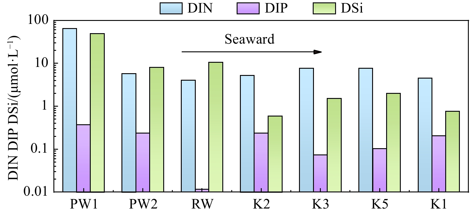
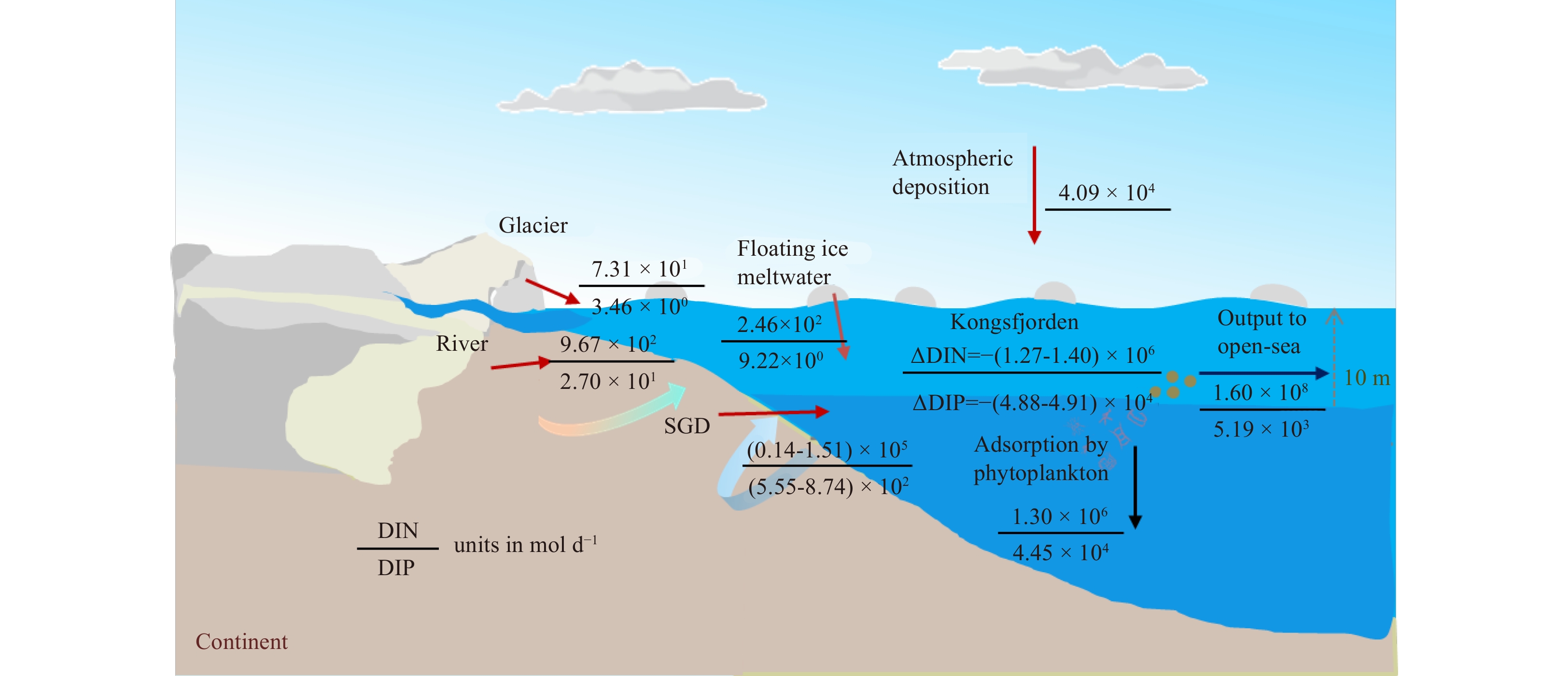
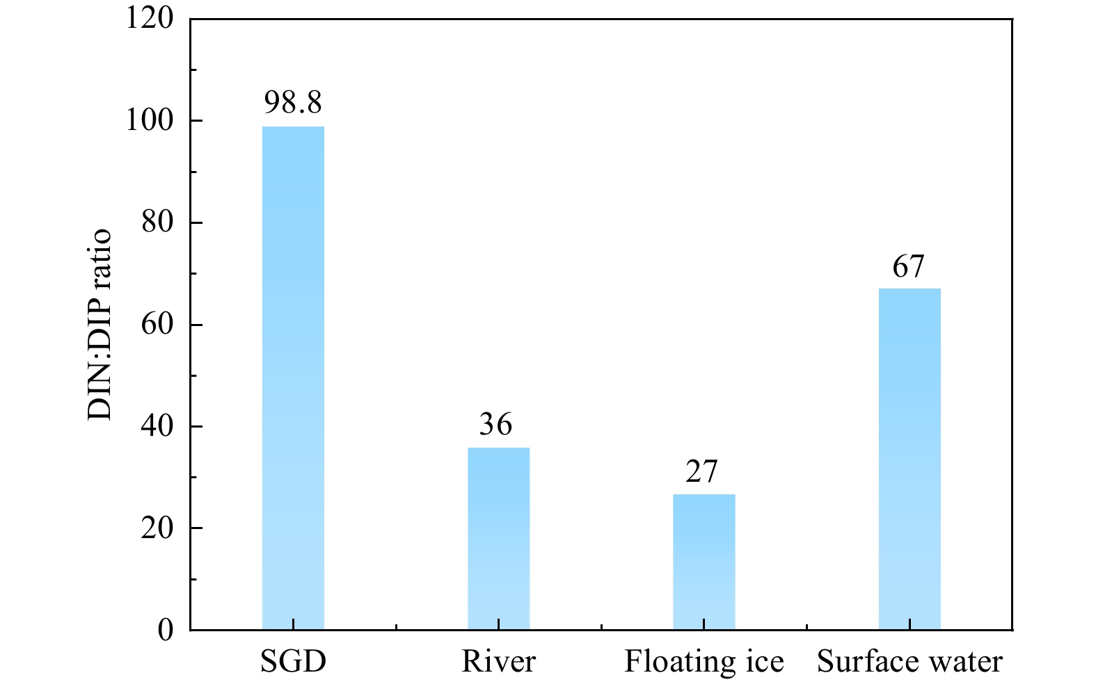
Under global climate change, water flow and related nutrient biogeochemistry in the Arctic are changing at an unprecedented rate, and potentially affect nutrient cycling in the Arctic Ocean. However, nutrient fluxes via submarine groundwater discharge (SGD) are potentially important yet poorly understood in the Arctic. Here we quantified that nutrient fluxes through radium-derived SGD were three orders of magnitude higher than those from the local river and constituted 25-96% of the total nutrient inputs into the Kongsfjorden. These large groundwater nutrient fluxes with high N/P ratio (average 99) may change the biomass and community structure of phytoplankton. Meanwhile, combining other SGD study cases around the Arctic region, SGD rates tend to increase over the past three decades, possibly on account of the effects of global warming. The SGD-derived nutrient may cause the increase of net primary productivity in the Arctic Ocean. The results will provide important basic data for land-ocean interactions in the typical fjord of the Arctic under the influence of global warming.
Under global climate change, water flow and related nutrient biogeochemistry in the Arctic are changing at an unprecedented rate, and potentially affect nutrient cycling in the Arctic Ocean. However, nutrient fluxes via submarine groundwater discharge (SGD) are potentially important yet poorly understood in the Arctic. Here we quantified that nutrient fluxes through radium-derived SGD were three orders of magnitude higher than those from the local river and constituted 25-96% of the total nutrient inputs into the Kongsfjorden. These large groundwater nutrient fluxes with high N/P ratio (average 99) may change the biomass and community structure of phytoplankton. Meanwhile, combining other SGD study cases around the Arctic region, SGD rates tend to increase over the past three decades, possibly on account of the effects of global warming. The SGD-derived nutrient may cause the increase of net primary productivity in the Arctic Ocean. The results will provide important basic data for land-ocean interactions in the typical fjord of the Arctic under the influence of global warming.


, Available online
Abstract:
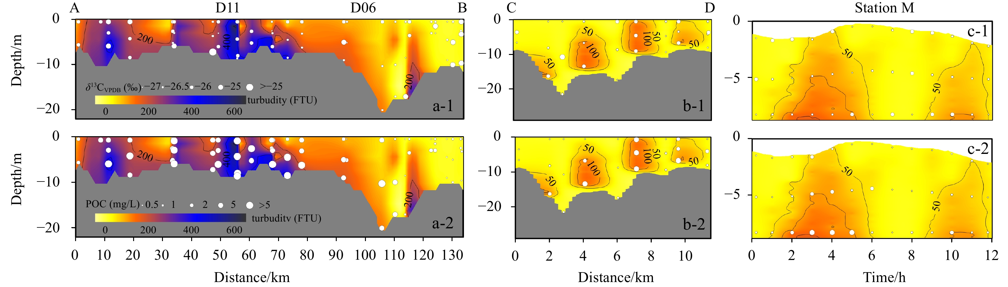
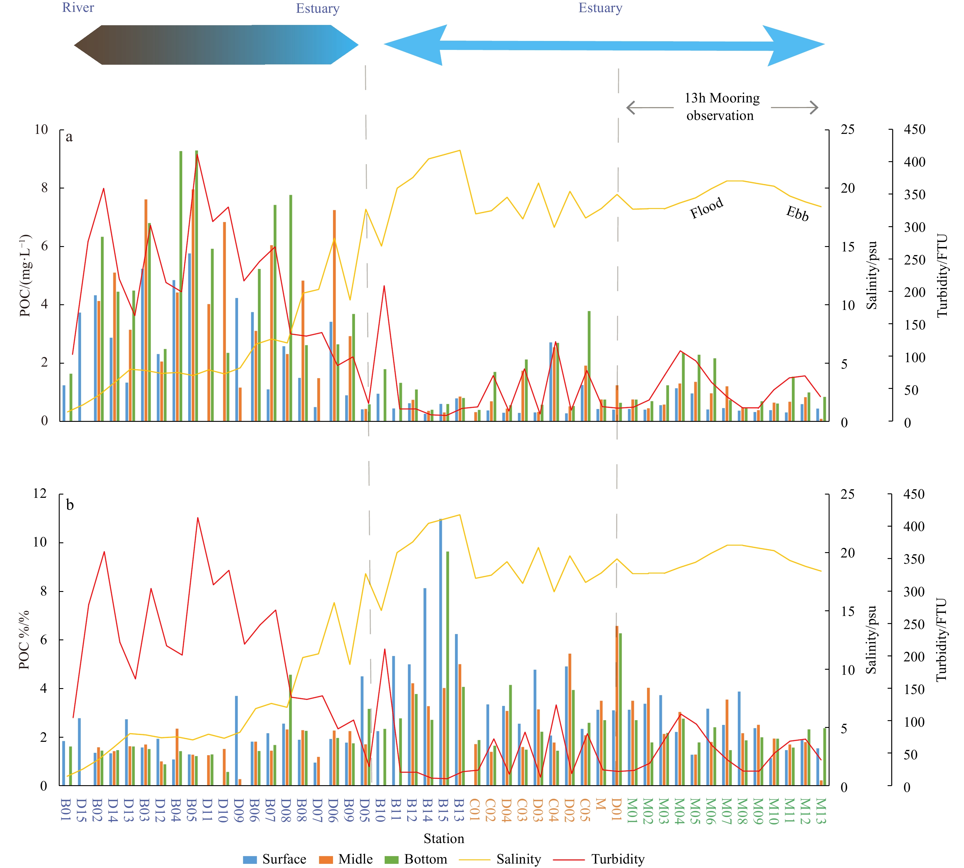
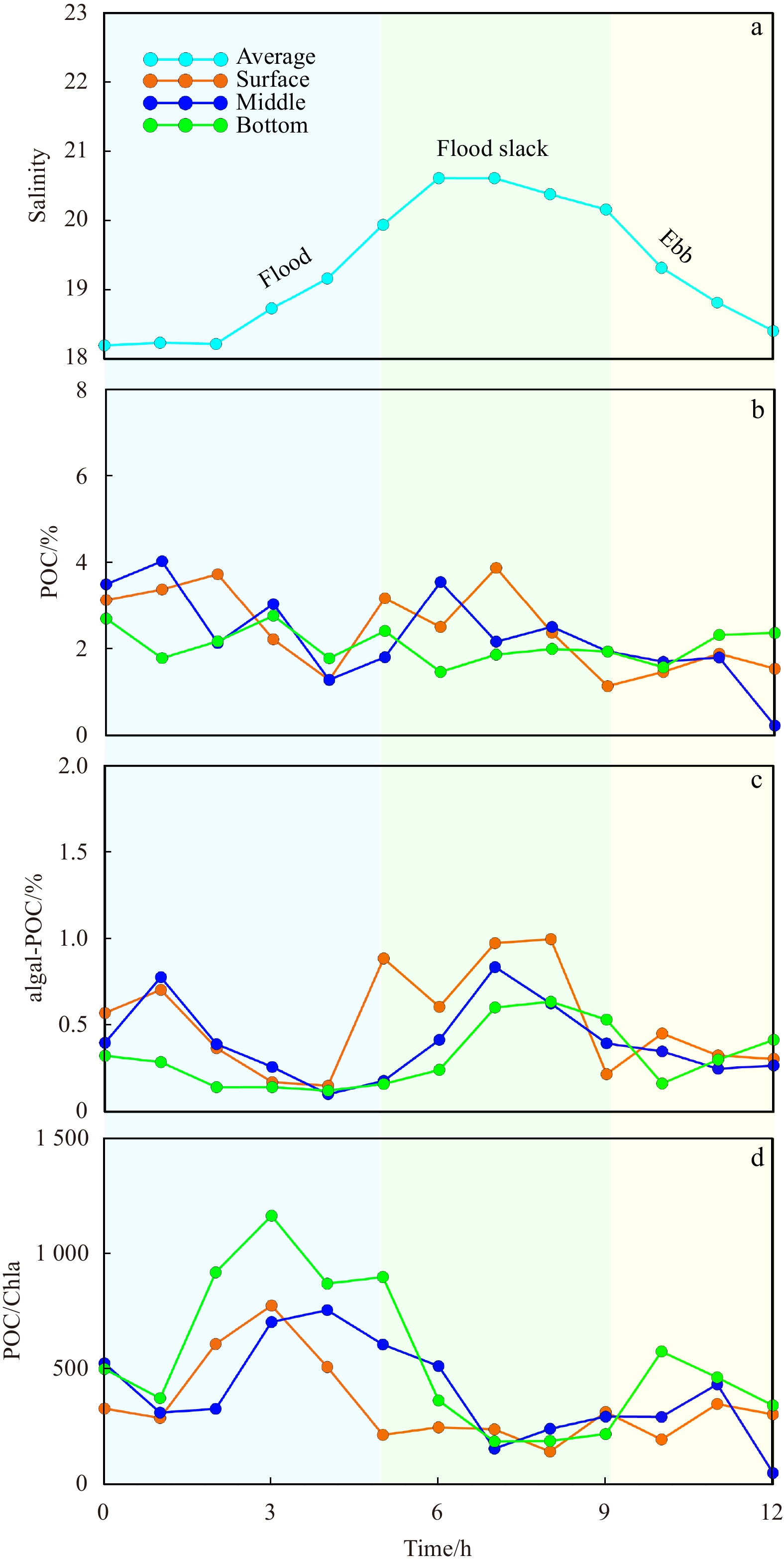
Global carbon cycle has received extensive attention, among which the river-estuary system is one of the important links connecting the carbon cycle between land and ocean. In this paper, the distribution and control factors of particulate organic carbon (POC) were studied by using the data of organic carbon contents and its carbon isotopic composition (δ13C) in the mainstream and estuary of Passur River in the Sundarban area, combined with the hydrological and biological data measured by CTD. The results show that POC content ranged from 0.263 to 9.292 mg/L, and the POC content in the river section (averaged 4.129 mg/L) was significantly higher than that in the estuary area (averaged 0.858 mg/L). Two distinct stages of POC transport from land to sea in the Sundarban area were identified. The first stage occurred in the river section, where POC distribution was mainly controlled by the dynamic process of runoff and the organic carbon was mainly terrestrial source. The second stage occurred during estuarine mixing, where the POC distribution was mainly controlled by the mixing process of seawater and freshwater. The source of POC was predominantly marine and exhibiting vertical differences. The surface and middle layers were primarily influenced by marine sources, while the bottom layer was jointly controlled by terrestrial and marine sources of organic carbon. These findings are of great significance for understanding the carbon cycle in such a large mangrove ecosystem like the Sundarban Mangrove.
Global carbon cycle has received extensive attention, among which the river-estuary system is one of the important links connecting the carbon cycle between land and ocean. In this paper, the distribution and control factors of particulate organic carbon (POC) were studied by using the data of organic carbon contents and its carbon isotopic composition (δ13C) in the mainstream and estuary of Passur River in the Sundarban area, combined with the hydrological and biological data measured by CTD. The results show that POC content ranged from 0.263 to 9.292 mg/L, and the POC content in the river section (averaged 4.129 mg/L) was significantly higher than that in the estuary area (averaged 0.858 mg/L). Two distinct stages of POC transport from land to sea in the Sundarban area were identified. The first stage occurred in the river section, where POC distribution was mainly controlled by the dynamic process of runoff and the organic carbon was mainly terrestrial source. The second stage occurred during estuarine mixing, where the POC distribution was mainly controlled by the mixing process of seawater and freshwater. The source of POC was predominantly marine and exhibiting vertical differences. The surface and middle layers were primarily influenced by marine sources, while the bottom layer was jointly controlled by terrestrial and marine sources of organic carbon. These findings are of great significance for understanding the carbon cycle in such a large mangrove ecosystem like the Sundarban Mangrove.


, Available online
Abstract:
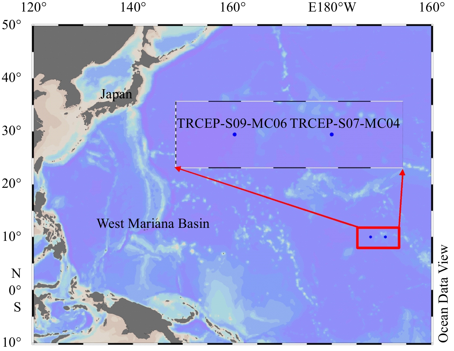
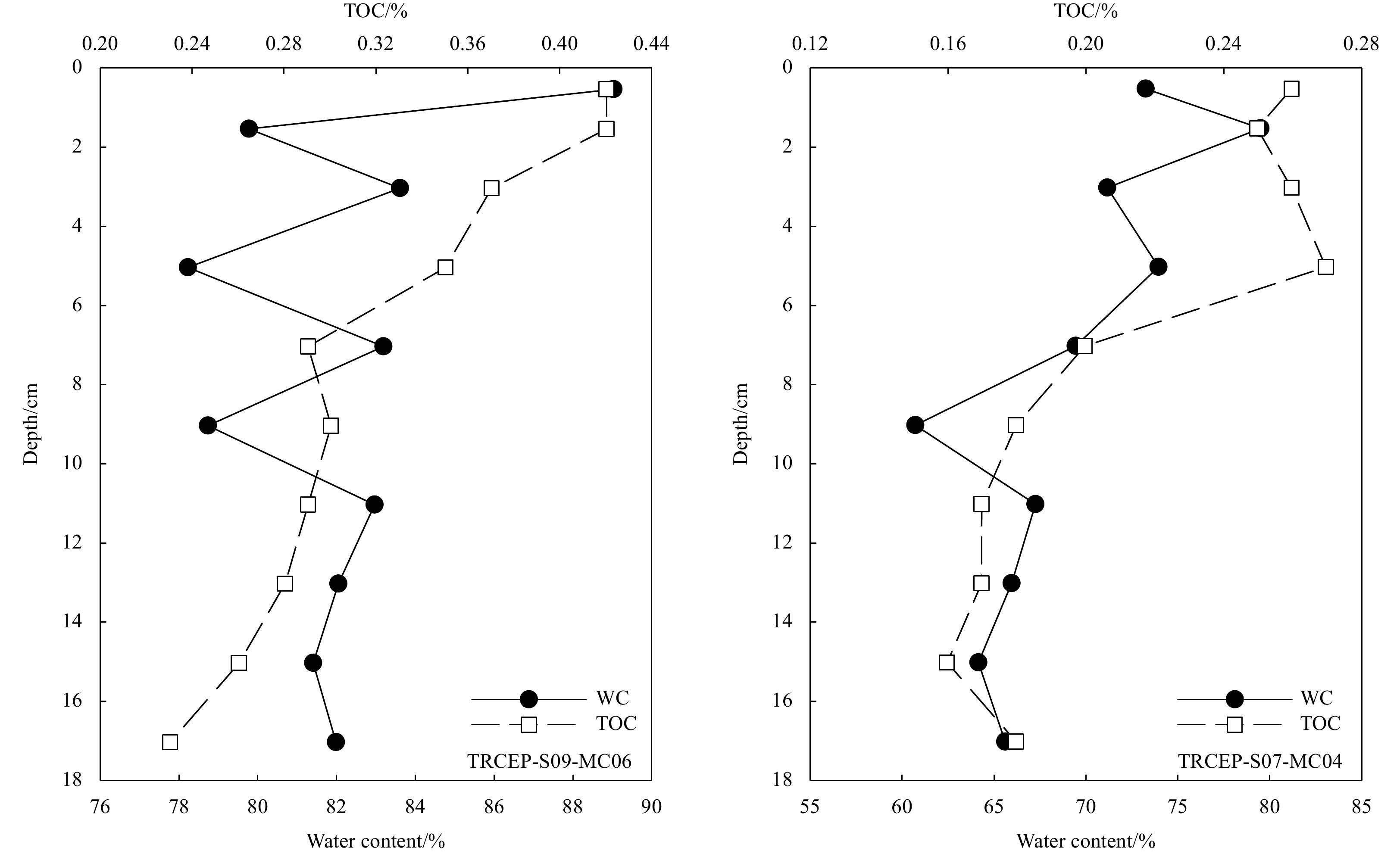
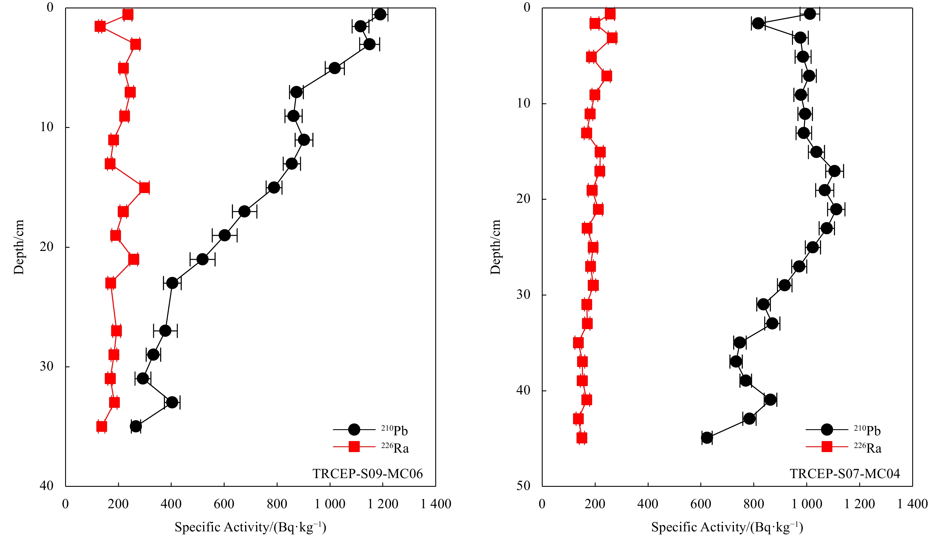
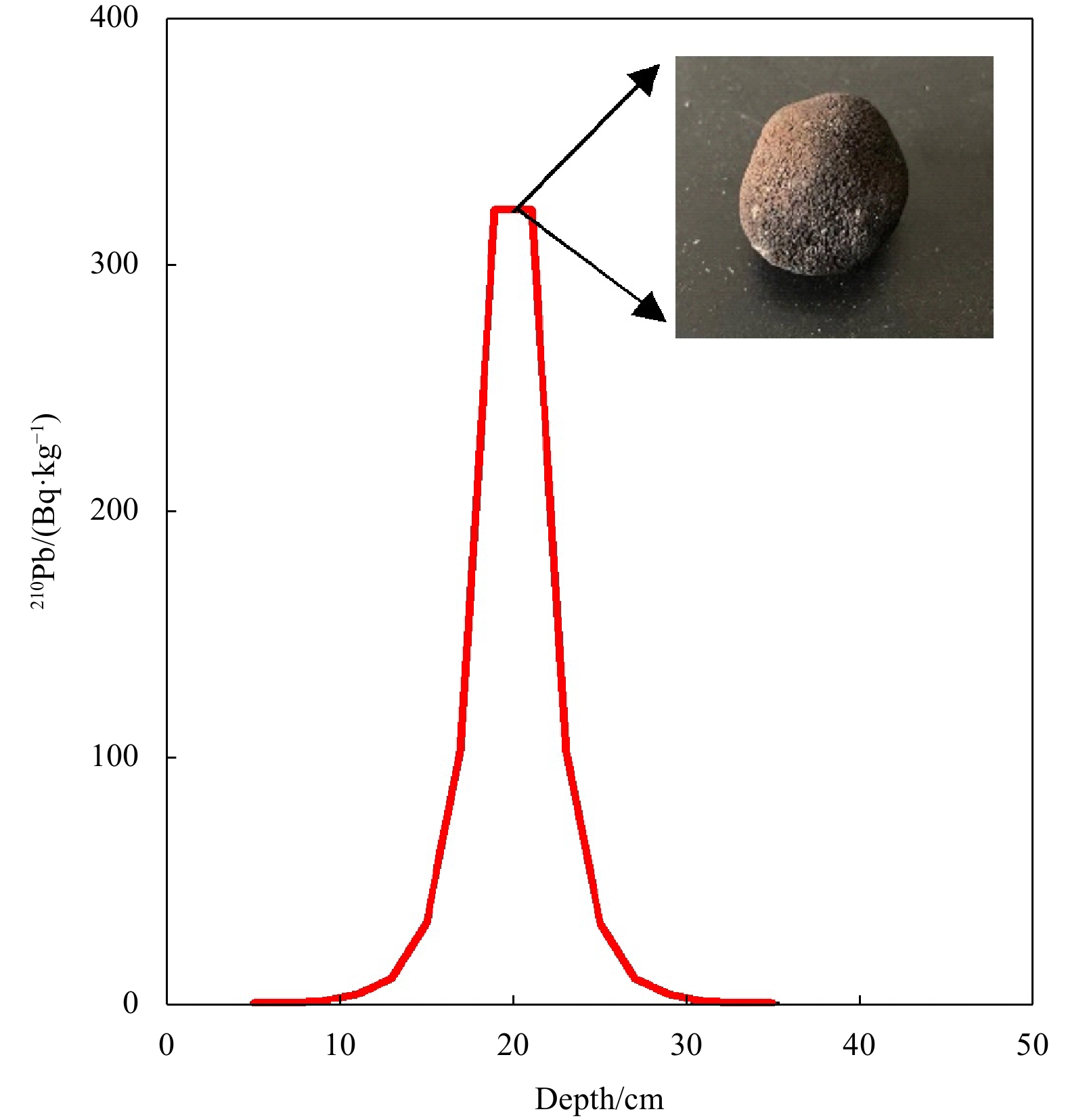
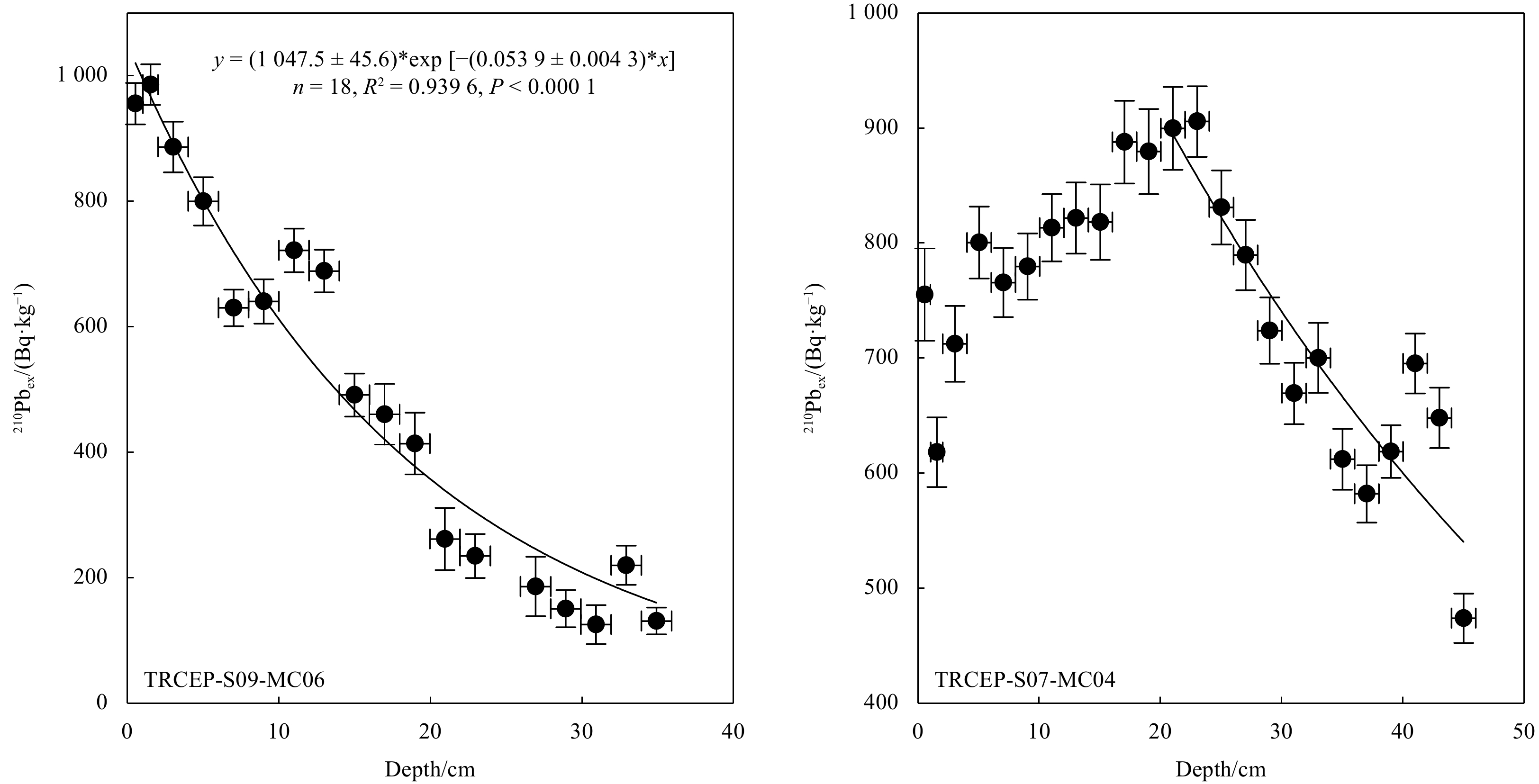
The biogeochemical processes of marine sediments are influenced by bioturbation and organic carbon decomposition, which is crucial for understanding global element cycles and climate change. Two sediment cores were acquired in 2017 from abyssal basins in the central-eastern tropical Pacific to determine the bioturbation and organic carbon degradation processes. The radioactivity concentrations of 210Pb and 226Ra in the sediment cores were measured, indicating the presence of significant excess 210Pb (210Pbex) signals in the sediment cores. Besides, a manganese nodule was discovered in one core, which had a substantial influence on the distribution of 210Pbex. With the exception of this anomalous finding, the bioturbation coefficients in the remaining core were estimated to be 10.6 cm2/a using a steady-state diffusion model, greater than most of the deep-sea sediments from the Equatorial Eastern Pacific. By using a bio-diffusion model, we further calculated the degradation rates of organic carbon (8.02 ka-1), which is also higher than other areas of the Pacific. Our findings displayed the presence of a biologically active benthic ecosystem in the central-eastern tropical Pacific.
The biogeochemical processes of marine sediments are influenced by bioturbation and organic carbon decomposition, which is crucial for understanding global element cycles and climate change. Two sediment cores were acquired in 2017 from abyssal basins in the central-eastern tropical Pacific to determine the bioturbation and organic carbon degradation processes. The radioactivity concentrations of 210Pb and 226Ra in the sediment cores were measured, indicating the presence of significant excess 210Pb (210Pbex) signals in the sediment cores. Besides, a manganese nodule was discovered in one core, which had a substantial influence on the distribution of 210Pbex. With the exception of this anomalous finding, the bioturbation coefficients in the remaining core were estimated to be 10.6 cm2/a using a steady-state diffusion model, greater than most of the deep-sea sediments from the Equatorial Eastern Pacific. By using a bio-diffusion model, we further calculated the degradation rates of organic carbon (8.02 ka-1), which is also higher than other areas of the Pacific. Our findings displayed the presence of a biologically active benthic ecosystem in the central-eastern tropical Pacific.
, Available online
Abstract:
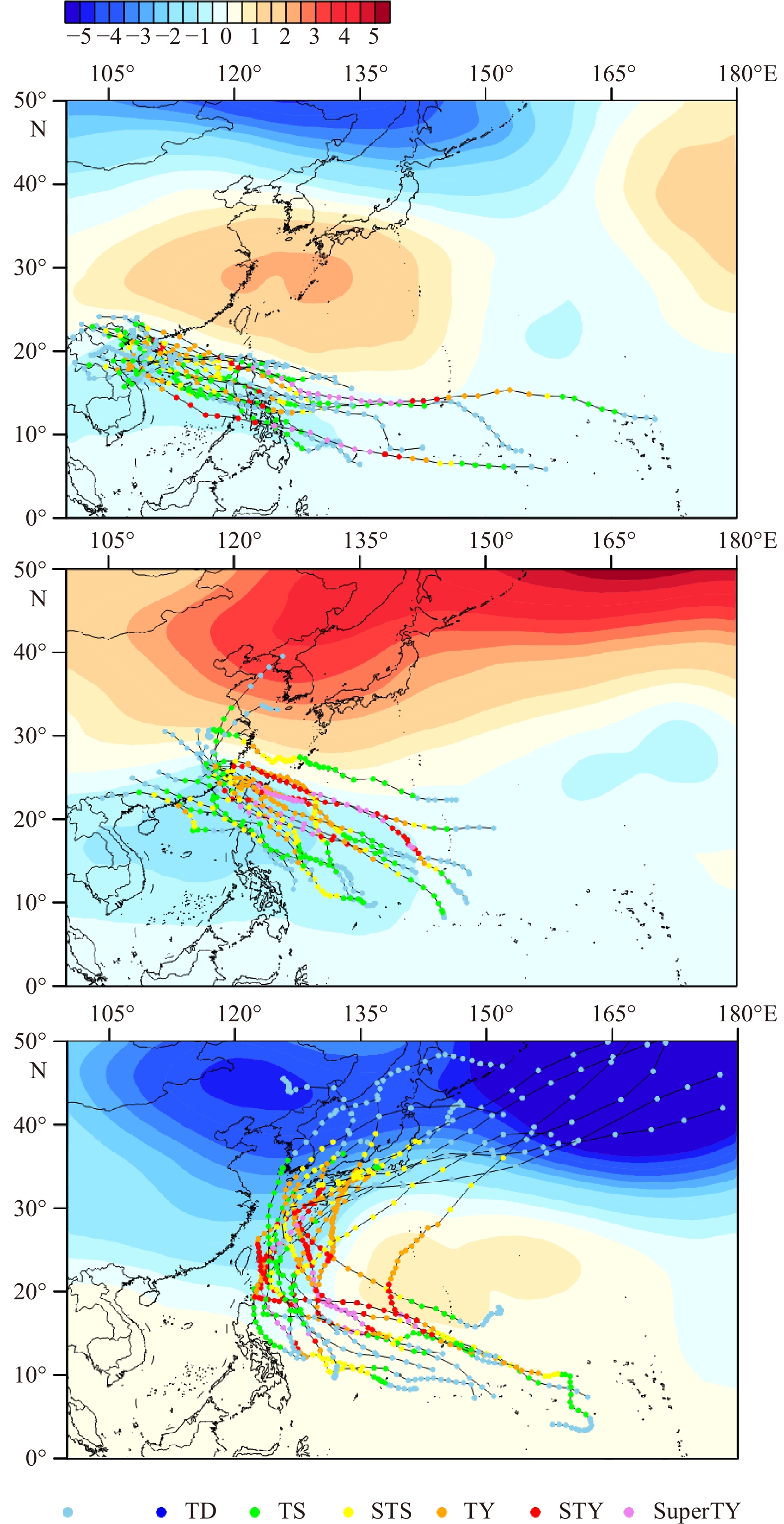
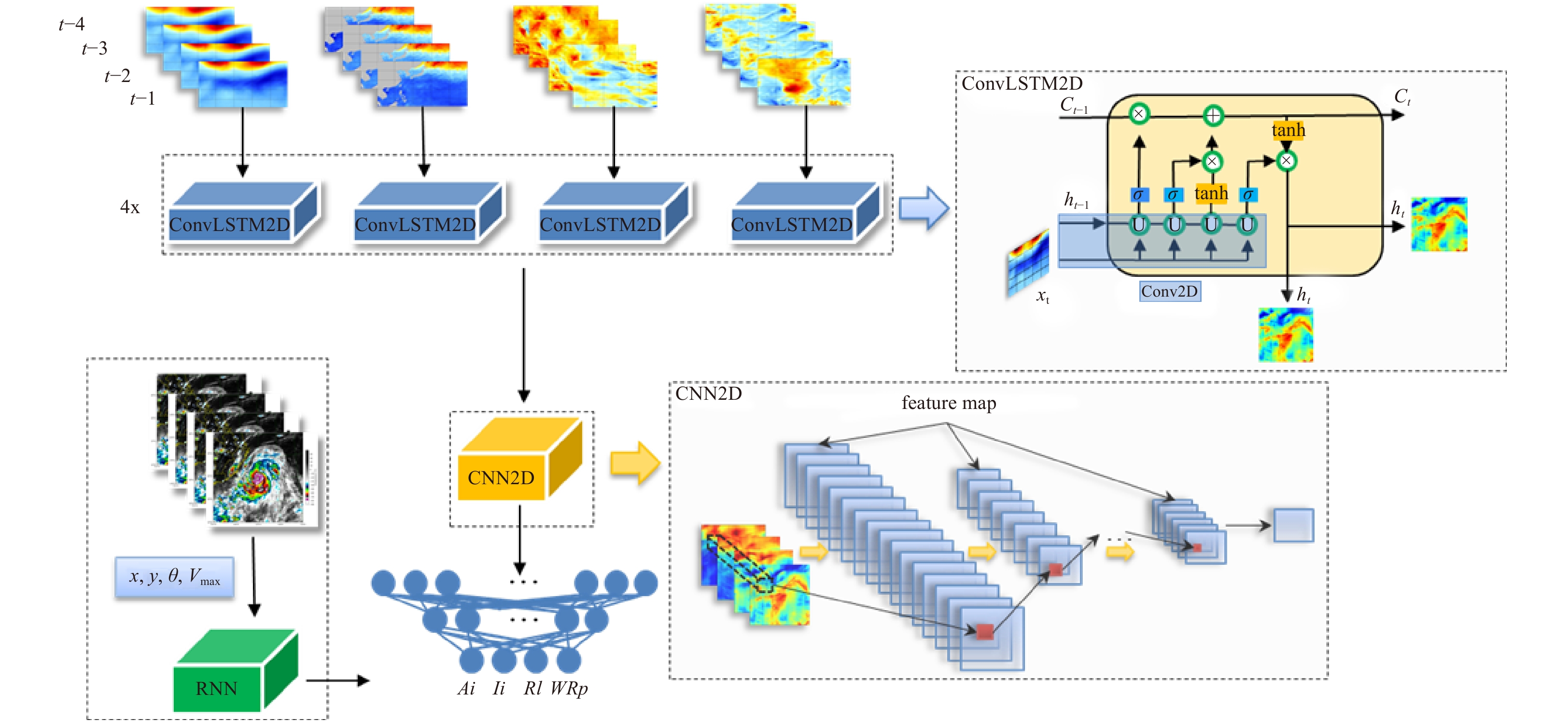
Seasonal location and intensity changes in the western Pacific subtropical high (WPSH) are important factors dominating the synoptic weather and the distribution and magnitude of precipitation in the rain belt over East Asia. Therefore, this article delves into the forecast of the western Pacific subtropical high index during typhoon activity by adopting a hybrid deep learning model. Firstly, the predictors, which are the inputs of the model, are analysed based on three characteristics: the first is the statistical discipline of the WPSH index anomalies corresponding to the three types of typhoon paths; the second is the correspondence of distributions between sea surface temperature (SST), 850 hPa zonal wind (u), meridional wind (v), and 500 hPa potential height field; and the third is the numerical sensitivity experiment, which reflects the evident impact of variations in the physical field around the typhoon to the WPSH index. Secondly, the model is repeatedly trained through the backward propagation algorithm to predict the WPSH index using 2011-2018 atmospheric variables as the input of the training set. The model predicts the WPSH index after 6 h, 24 h, 48 h, and 72 h. The validation set using independent data in 2019 is utilized to illustrate the performance. Finally, the model is improved by changing the CNN2D module to the DeCNN module to enhance its ability to predict images. Taking the 2019 Typhoon Lekima as an example, it shows the promising performance of this model to predict the 500 hPa potential height field.
Seasonal location and intensity changes in the western Pacific subtropical high (WPSH) are important factors dominating the synoptic weather and the distribution and magnitude of precipitation in the rain belt over East Asia. Therefore, this article delves into the forecast of the western Pacific subtropical high index during typhoon activity by adopting a hybrid deep learning model. Firstly, the predictors, which are the inputs of the model, are analysed based on three characteristics: the first is the statistical discipline of the WPSH index anomalies corresponding to the three types of typhoon paths; the second is the correspondence of distributions between sea surface temperature (SST), 850 hPa zonal wind (u), meridional wind (v), and 500 hPa potential height field; and the third is the numerical sensitivity experiment, which reflects the evident impact of variations in the physical field around the typhoon to the WPSH index. Secondly, the model is repeatedly trained through the backward propagation algorithm to predict the WPSH index using 2011-2018 atmospheric variables as the input of the training set. The model predicts the WPSH index after 6 h, 24 h, 48 h, and 72 h. The validation set using independent data in 2019 is utilized to illustrate the performance. Finally, the model is improved by changing the CNN2D module to the DeCNN module to enhance its ability to predict images. Taking the 2019 Typhoon Lekima as an example, it shows the promising performance of this model to predict the 500 hPa potential height field.

, Available online , doi: 10.1007/s13131-020-1589-x
Abstract:
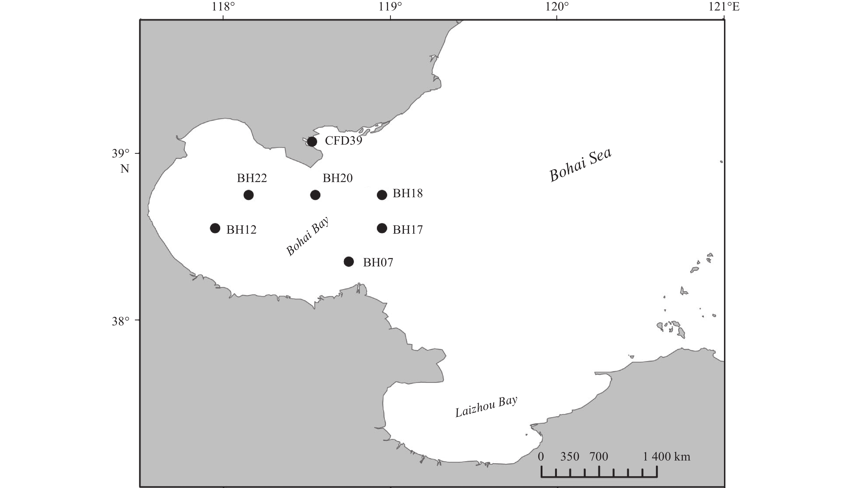
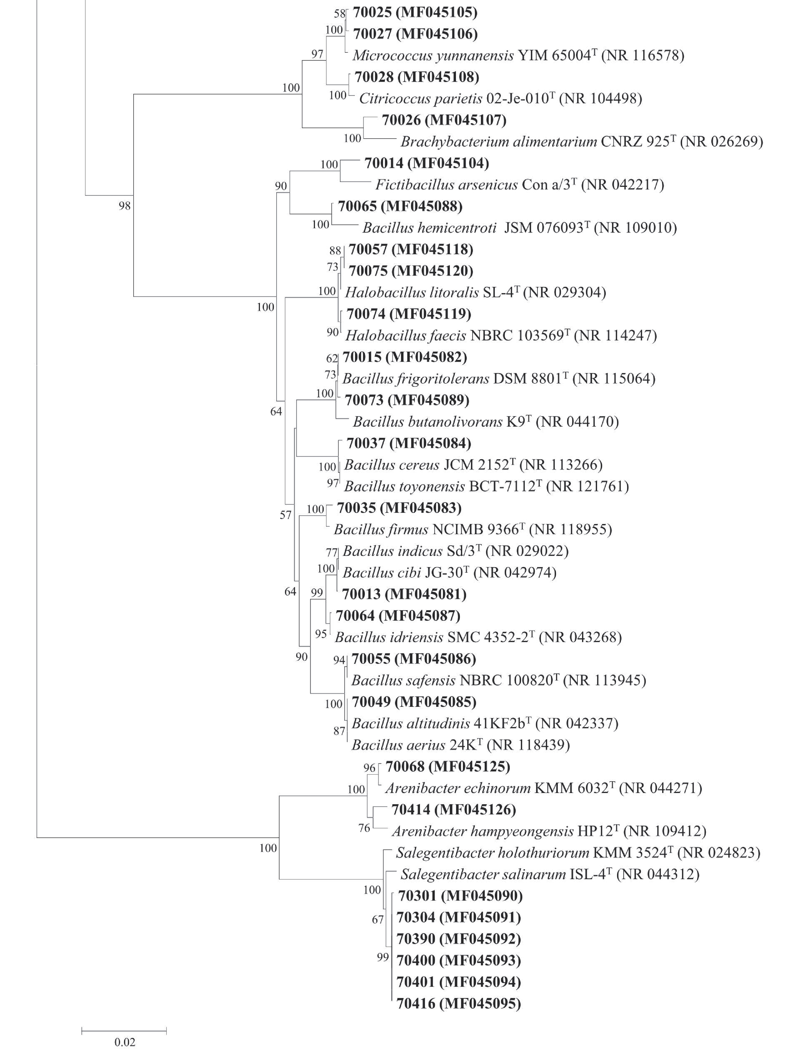
Protease-producing bacteria play key roles in the degradation of organic nitrogen materials in marine sediments. However, their diversity, production of proteases and other extracellular enzymes, even in situ ecological functions remain largely unknown. In this study, we investigated the diversity of cultivable extracellular protease-producing bacteria in the sediments of the Bohai Bay. A total of 109 bacterial isolates were obtained from the sediments of 7 stations. The abundance of cultivable protease-producing bacteria was about 104 CFU/g of sediment in all the samples. Phylogenetic analysis based on 16S rRNA gene sequences classified all the isolates into 14 genera from phyla Proteobacteria, Firmicutes, Bacteroidetes and Actinobacteria, with Pseudoalteromonas (63/109, 57.8%), Bacillus (9/109, 8.2%), Sulfitobacter (8/109, 7.3%) and Salegentibacter (6/109, 5.5%) as the dominant taxa. Enzymatic inhibition tests indicated that all the tested isolates produced serine and/or metalloprotease, with only a small proportion producing cysteine and/or aspartic proteases. Several extracellular enzyme activities, including alginase, lipase, amylase and cellulose, and nitrate reduction were also detected for strains with higher protease activities. According the results, the protease-producing bacteria could also be participate in many biogeochemical processes in marine sediments. Our study broadened understanding and knowledge on the potential ecological functions of protease-producing bacteria in marine sediments.
Protease-producing bacteria play key roles in the degradation of organic nitrogen materials in marine sediments. However, their diversity, production of proteases and other extracellular enzymes, even in situ ecological functions remain largely unknown. In this study, we investigated the diversity of cultivable extracellular protease-producing bacteria in the sediments of the Bohai Bay. A total of 109 bacterial isolates were obtained from the sediments of 7 stations. The abundance of cultivable protease-producing bacteria was about 104 CFU/g of sediment in all the samples. Phylogenetic analysis based on 16S rRNA gene sequences classified all the isolates into 14 genera from phyla Proteobacteria, Firmicutes, Bacteroidetes and Actinobacteria, with Pseudoalteromonas (63/109, 57.8%), Bacillus (9/109, 8.2%), Sulfitobacter (8/109, 7.3%) and Salegentibacter (6/109, 5.5%) as the dominant taxa. Enzymatic inhibition tests indicated that all the tested isolates produced serine and/or metalloprotease, with only a small proportion producing cysteine and/or aspartic proteases. Several extracellular enzyme activities, including alginase, lipase, amylase and cellulose, and nitrate reduction were also detected for strains with higher protease activities. According the results, the protease-producing bacteria could also be participate in many biogeochemical processes in marine sediments. Our study broadened understanding and knowledge on the potential ecological functions of protease-producing bacteria in marine sediments.